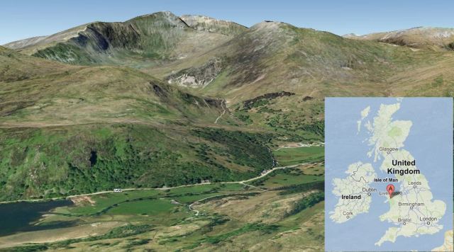
View of Mount Snowdon using Googleearth by Karenz.
Snowdon is the highest mountain in Wales and an extinct volcano. The summit is easily accessible on foot, by train or you can practice your mountaineering skills there – as apparently did Sir Edmund Hillary to train for the ascent of Mt Everest. I walked it; mountaineering is not one of my skills.
Snowdon is well worth a visit as it is in a national nature reserve for rare flora and fauna.
Wales has had a marked influence on geology. Early geologists defined periods based on the names of Welsh villages. “Ordovician” is named after a Celtic tribe, the Ordovices.
Snowdon formed during the Ordovician period. It is comprised of tuff with sedimentary rocks and igneous intrusions, folded into a syncline. Around 450 ma, a caldera formed, producing ash flows of rhyolitic tuff deposits up to 500 metres (1,600 ft) thick. The current summit at 1,085 metres (3,560 ft) is near the northern edge of the caldera.

Fig 1: The Snowdon Massif (Wiki Commons, http://en.wikipedia.org/wiki/
File:North_snowdonia_panorama.jpg)
Much of Wales was under water in the Ordivician period. Wales was in a back arc basin between a subduction zone and in front of the Midland Platform. The basin had both submarine and sub aerial volcanoes. While I have focussed on the volcanic activity, there was a lot of sedimentary activity occurring as well so igneous and sedimentary rocks often form consecutive layers.
Tectonic Setting
England and Wales were part of the Avalonia micro plate; Scotland was then sited on the Laurentia plate and did not join England and Wales until much later during the Caledonian Orogeny. In the early Ordovician period, Avalonia was a volcanic arc on the northern edge of Gondwana where the Iapetus ocean crust subducted under the Gondwana plate. As the Iapetus Ocean closed, Avalonia broke off from Gondwana and moved northward to eventually meet the Laurentia and Baltica plates.
The collision of the plates resulted in the Caledonian Orogeny around 490 ma to 390 ma, the building of a chain of mountains which stretched from the Appalachians, through Snowdonia and the Lake District to Norway.
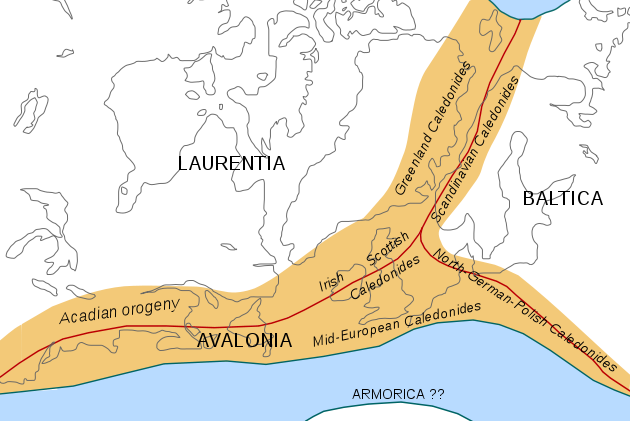
Fig 2: Caledonian/Acadian Mountain Chains (Woudloper, Wiki Commons http://en.wikipedia.org/
wiki/File:Caledonides_EN.svg))
Volcanic Activity
For Avalonia, volcanism of the Tremadoc era, c. 510 ma, was island arc, whereas the subsequent volcanism of the Llanvirn and Caradoc eras was characteristic of a back arc environment. Wales, itself, was the site of a back arc basin with voluminous calc-alkaline basaltic and rhyolitic volcanic activity which ended with the meeting of the three terranes in the late Ordovician. Acidic lavas were produced by subduction and basaltic lavas were produced by thinning of the crust of the back arc basin.
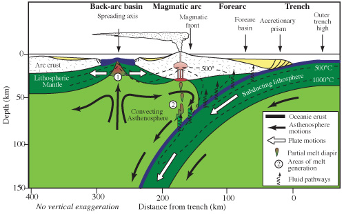
Fig 3: Profile of a Back Arc Basin and Subduction Zone (zyzzy2, Wiki Commons, http://
en.wikipedia.org/wiki/File:SubZone.jpg)
Early volcanic activity in the Tremadoc was sub aerial, followed by a period of submarine activity in the Caradoc and sub aerial again in the Ashgill.
The Snowdon Volcanic Corridor
The Snowdon volcanic corridor was built in two phases: the Llewelyn volcanic group and the Snowdon volcanic group. These are separated by sedimentary rocks.
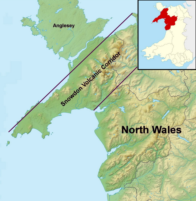
Fig 4: Snowdon Volcanic Corridor (based on a map by Nilfanion, Wiki Commons, http://en.wikipedia.org/wiki/File:Gwynedd_UK_relief_location_map.jpg)
The Llewelyn group had five main formations: Conway – rhyolite and ash flow lavas; Foel Fras – andesitic lava and tuffs; Foel Grach – basaltic – andesitic lava; Braich Tu Du – acidic ash flow and rhyolitic tuff; and, the Capel Curig – formation of both sub aerial and submarine acidic ash flow and tuffs.
The Snowdon Volcanic Group had three centres: Llwyd Mawr – an emerging volcanic island that produced acid ash flow tuffs that were partially contained in a subsiding caldera; Snowdon, itself; and, Crafnant –deep water acidic submarine tuffs. Snowdon evolved as initial ash flow tuffs from a series of fissures south east of the volcano. The caldera subsided as more ash was erupted. This was followed by pumice and rhyolite. Ash flow tuffs were partially contained by the caldera.
Basaltic rocks also occur alongside acidic: both intrusive and extrusive basalts are found and also hyaloclastites. The sequence is acidic followed by basaltic and then a final rhyolitic phase.
At the end of the Caradoc, most volcanic activity ceased, although there were some minor eruptions later in the region. Successive orogeny episodes led to mineralisation of the faults in the region and further uplift. There are no rocks in the area that are younger than the Triassic period. Any that might have been deposited have since been eroded. Glaciation during the Cenozaic Ice Age and subsequent erosion from wind and rain formed the current landscape, revealing the underlying geology of Snowdonia.
KarenZ, 26/12/2012.
References:
http://en.wikipedia.org/wiki/Avalonia
http://en.wikipedia.org/wiki/Ordovician
http://en.wikipedia.org/wiki/Snowdonia
“British Regional Geology Wales”, M F Howells, British Geological Survey, 2007
“Geology of Snowdonia”, Matthew Bennett, The Crowood Press, 2007.


Nice one Karen – really good to learn about a UK volcano!
Thank you
It’s great to see so many people ‘on Mt Snowdon’ today!!! Thanks Karen 😀
Blwyddyn Newydd Dda!! – i bawb
Happy New Year! – to you all
Happy New Year Everyone.!!
Looking at the new earthquakes at El Hierro, looks like a new area is now undermined. Is the idea that meanwhile the whole island becomes a cork on a bottle….
Here is an updated link to all the new quakes on El Hierro,
http://www.ign.es/ign/layoutIn/volcaListadoTerremotos.do?zona=2&cantidad_dias=10
I had been very busy yesterday and hadn’t noticed there had been so many after the long lull in quakes from 24th December.
Interesting and I will be keeping a closer eye on it from now on. Now have to dash off.
Karen, lovely post. Thanks for all that info. I have walked up Snowden a few times and never thought about it being an extinct volcano. DOH!
I even never thought there would be extinct volcanoes in Britain til not so long ago! 😯
Really nice and interesting read, thank you, KarenZ. 🙂
Hi there, morning to all
I’ll do a plot this evening but there seems to be a new zone for the recent EQs.
Look forward to it.
Here is a quick look at Vp and Vs speeds: http://oi45.tinypic.com/35kssnt.jpg
Hi Karen
the correlation seems quite good. Did you calcultate it directly (I mean using the time difference and depth as distance?)
Also your post is very interesting, thanks for it, learning quite a few things is always a good way to start the year.
Calculated it directly using estimated depth (formula similar to GeoLurking’s straight ray path, which produces slightly longer depths than published depths) and time differences (eg P arrival time minus origin time).
OK, thanks
Very well written and documented, Karen. Good topic – extinct volcanoes are almost everywhere, often right under our feet, but we know so little about them. Thanks!
And a Happy New Year to everyone!
Beautifully written and presented Karen, thank you!
Thank you for the feedback; and, thank you to Schteve42, Sissel and Spica who helped sort out an incorrect link that I gave them.
Excellent post Karenz x Thanks for your hard work. it’s greatly appreciated by the dragons.
Who’s next? 😀
Thank you for the excellent post. I’ve never been up Snowdon but have seen it from the base – like Newby I failed to appreciate its origin. I really must learn to read the ground beneath my feet!
Had no idea it was that extensive..
Nice job..
Here is a short but interesting article about how global warming has an influence on increasing volcanic activity.
http://insidecostarica.com/2012/12/30/researchers-climate-change-affects-frequency-of-volcanic-eruptions/
Actually, what they found was Lithospheric Rebound. A process that has been known about for years.
If you want to see it first hand, take a look at pretty much any of the Icelandic GPS sites.
Increased sediment load because of glacier melt on subduction zones could also contribute to higher volcanism.
Dunno if that flies or not.
The Himalayas have massive run-off due to monsoonal flow running up the south face, eroding copious amount of material that then flows down in the Indus and Ganges river basins…. yet the amount of volcanism in India doesn’t seem to be much higher than normal. Granted, it’s a continental convergent zone and not a subduction zone.
Monterey canyon, on the shelf off the coast of Monterey California, is believed to be the outflow erosion channel for the Colorado river when that portion of the Pacific Plate lined up with where the Salton Sea is right now. Other than the normal activities of the Farallon and the two plates that were subducted before it… it would be difficult to prove that sediment load increased the volcanism.
The accretionary prism along Japan’s eastern coast is huge…. but there are no glaciers or large watersheds to provide the run-off…. and Japan has one of the more seismically active subduction zones.
Logically, it seems sound, but the evidence for it is lacking.
Oh, the paper (http://oceanrep.geomar.de/19607/ “A detection of Milankovitch frequencies in global volcanic activity” Kotterolf, Geology 2012) correlates the Milankovitch cycle (http://en.wikipedia.org/wiki/Milankovitch_cycles) of 41 000 years due to the angle between Earth’s rotational axis and the normal to the plane of its orbit (obliquity) to a higher occurence of tephra layers with a lag of 4000 years after maximally decreasing ice volume.
That would of course by far not be enough time for subducted sediment to cause such an effect (appr. 10 cm/yr would be 400 m in 4000 years vs 100 km distance of back-arc volcanoes from the trench.
Btw, while the paper is paywalled, here is a link to the data repository 🙂 ftp://rock.geosociety.org/pub/reposit/2013/2013055.pdf
Despite the fact that it’s paywalled, I bet this paper and it’s research are probably spinning a few wingnuts bonkers.
Milankovitch cycles have long been “poo-poo’d” by the anti-human crowd as being of little significance.
They also tend to ignore Bond, Heinrich events and Dansgaard-Oeschger events.
If history is any teacher… Bond Zero should be either here or just around the corner.
http://chiefio.wordpress.com/tag/bond-event/
Probably a couple of the better ones are:
http://chiefio.wordpress.com/2012/12/15/d-o-ride-my-see-saw-mr-bond/
and
http://chiefio.wordpress.com/2011/02/22/intermediate-period-half-bond-events/
According to that Europe may soon freeze over while Florida may flourish. Has it started to prepare for the legions of European refugees?
We better learn quickly how to properly climate-engineer….
We already have a plan for the European refugees. The Florida Snowbird. An invasive species that has already taken over the swampy coastal regions to the south.
In fact, he was asked that very question, here’s his response: (bold added)
http://chiefio.wordpress.com/2012/12/15/d-o-ride-my-see-saw-mr-bond/
I like Chiefio’s musings. He has a strong tendency to cite his sources and doesn’t go trotting off on a wild hair (or hare, if you are into rabbits). That that isn’t proved, is left un-proven but expounded upon with correlation and query (if possible).
In one of his postings, he mentions Vukcevic. Vukcevic is an “out there” sort of ruminator, though he tends to back most of his claims with observational or calculated evidence. What the quality of that evidence is, I’ll not comment on. I don’t know enough to shoot it down, though I can’ say that he hasn’t been vehemently derided for his claims.
One thing that I have always insisted on before I will give an argument or a claim half a thought… is if a mechanism can be identified that may allow the claim to work.
What Chiefio saw was something (evidence of a mechanism) that could support Vukcevic claims.
It’s one thing to see apparent correlation… it’s another to prove causation.
The fact that Bond, Heinrich events and Dansgaard-Oeschger events are real flies in the face of a lot of climate “research” by the anti-human groups.
The 1470 year cycle of the Bond events (≈ 1500 years) really give you pause when you look at little tidbits such as 2012 – 1470 = 542 AD. That’s about the time that the “Dark Ages” came into full swing for some reason or another. (Note, the “”Dark Age” is actually an invention of Renaissance thinkers as a way of labeling the period. It was a ‘they weren’t as enlightened as we are so they must have been in the dark’ sort of mentality. War, pestilence, famine were rampant. This was the migration period when most of our ancestors wound up in the locations where we claim our ancestry from today. (Somehow mine wound up in Düsseldorf). So, there was motivation to move. How much was due to the invaders from the East, how much from the power vacuum of a collapsing ex-Roman empire, how much from climate excursions?
It’s a lot to ponder once you eliminate the bullshit of “human caused global whatever” and actually look at the real, long term data.
More from Cheifio… though this one doesn’t deal with Bond events.
http://chiefio.wordpress.com/2012/12/29/annoying-lead-time-graph/
According to GVP, Rabaul had one of it’s caldera forming events around 540 AD. VEI-6 at 1.1 x 10^10 m³ (bulk tephra).
And natch… our favorite sneaky bad ass may have had a hand in it…
Notice that the Loch Portain tephra… dated at 540 and 310 (two layers) have chemical signatures not that different from Hekla’s known tephras.
Came across this paper on a chiefio wordpress site I had saved to read later:
Long link text removed. Try this one that won’t overflow the page.
Apologies for the long link there – it is an interesting article researching the effects of meteor and comet impacts on landscape, shoreline and weather, with some really vivid descriptions. It is something to contemplate, given the fairly regular historical nature of the events recorded here – and a new comet on its way.
http://www.space.com/17762-newfound-comet-dazzling-2013-display-c2012s1.html
For all: If you have a monstrously long link, odds are that if you can get it past the anti-spam mechanism, it will be broken once it shows up in the post. Use a site such as TinyUrl to get a shorter and more likly to work link. Typically small URLs made that way stay valid for a few days.
BTW… Alyson has linked a really nice article. Yeah, it’s a bit OT, but it explores the mining of folklore and legend into the exploration of not so ancient impact and geological events.
I give it a couple of dozen thumbs up.
Hi Karen, thank you for such an interesting first post for 2013, Takes me back a few years, I went on a school trip to Wales when I was about 15 and climbed (or walked) up to the summit of Snowdon – we stayed in a rather large youth hostel.. and I think that must have been the first place us school children had eaten real fresh eggs, I remember we all said “yuk” when we saw the really bright orange coloured yolks….- I remember there was snow on the summit & that I tripped and sprained my ankle on the way down…The Kendal Mint cake was nice though..I never knew that Snowdon was a volcano though,,,I just thought it was Wales highest & Great Britains 3rd hightest mountain…
We’ve got a lot of igneous rocks in the UK.
And the volcanic feature that I saw recently (which started me off on looking a lot more closely at the UKs volcanic past) does turn out to be an igneous intrusion in the Peak District ( ………… result 😀 ) but it does not have a name 😦
That is a result… I guess you get naming rights 🙂
Get the Name Karen Z! I live in an are where there are: 5 McCoy Creeks, 2 McCoy
Mountains. One McCoy gulch and one little Ghost town of McCoy..down by Frenchglen..
That is just Eastern Oregon…
Also none related to moi…
So you’re not the Real McCoy? I find that hard to believe. 😉
Not the dreaded Toadstones 🙂
Happy New Year Karen!
That was for the Derbyshire comment above – where were you?
On a train crossing the Pennines from Manchester to Sheffield.
& here it is: http://oi46.tinypic.com/nbfco.jpg

It looks better on Googe Earth but I haven’t managed to get a good shot yet of the view I got from the train 😉
I don’t think you could really say it’s a volcano, just made of volcanic rocks.
Along with a caldera 😕
I hope 2013 is a very active year for volcanoes. Tolbachik was a worthy winner for the Pliny award.
Rescued by Sissel. So sorry your comments mysteriously always end up in the spam.
To All: The Pliny Award is a yearly award handed out by Dr Erik Klemetti on his blog Eruptions http://www.wired.com/wiredscience/2012/12/and-the-2012-pliny-for-volcanic-event-of-the-year-goes-to/
Spica
Tremor levels rising in El Hierro, according to CTIG anyway. Plus many more small quakes.
http://www.ign.es/ign/head/volcaSenalesAnterioresDia.do?nombreFichero=CHIE_2013-01-01&ver=s&estacion=CHIE&Anio=2013&Mes=01&Dia=01&tipo=1
Idem for all stations, for example :
http://www.01.ign.es/ign/head/volcaSenalesAnterioresDia.do?nombreFichero=cjul_2013-01-01&ver=s&estacion=cjul&Anio=2013&Mes=01&Dia=01&tipo=1
http://www.01.ign.es/ign/head/volcaSenalesAnterioresDia.do?nombreFichero=cjul_2013-01-01&ver=s&estacion=cjul&Anio=2013&Mes=01&Dia=01&tipo=1
But it seems to decrease actually !
Fanfoe, you are right. When I posted it was still increasing and I was really hopeful it would continue. Ah well, we have another whole year to watch it still, can’t expect miracles in a few hours. 😀
Since Hierro is your “first” volcano I can understand your fascination with it but frankly, El Hierro is just as exciting a volcano as is watching paint dry. Tens and tens of thousands of earthquakes and all it has to show for it is a miniscule submarine eruption. After the last episode where several thousands of large earthquakes, many above M 4.0, failed to produce any result whatsover, why get excited over a dozen or so small ones and a tiny bit of “tremor” that could well have been caused by something not volcanic at all?
And all this when we have an ongoing and unusually large fissure eruption in Kamtchatka…
Well… El Hierro does have the aspect of being more heavily instrumented with publicly accessible data output than volcanoes on the Kamchatka peninsula.
I think El Hierro is a great little volcano from a fans perspective.
Sure, it will probably wind up being a plutonic emplacement in the long run, but it gives people something to watch from a point of view that you usually can’t find.
Evening all
Here is the update for the El Hierro earthquakes since December 12th.
To explain the plot here are the following points.
Earthquakes prior to 12th december 2012 are shown as small green dots.
The island terrain is shown as a surface in the first part of the video and as a mesh for easier earthquake viewing in the subsequent parts.
In the first part of the video, the one showing elevation color, the Moho is shown and also each new earthquake appears as a big red dot. I have removed the Moho layer for easier viewing afterwards.
The other earthquakes (since Dec 12) appear as blue dots, with dot size proportional to magnitude (look at the pink colored scale on one side of the plot).
In the last parts of the video the color of the dots is age related (up to 20 days) and proportional to magnitude.
As we can see there are quite a few events (about one hundred in less than 2 days).
Also the quakes’ depth is for the time being under the Moho layer, so I think we can safely say that the action is still far from the surface.
One very interesting point is that it seems that the location of the events is quite new, meaning that this new zone has not seen many earthquakes before. This could mean it is a new bolus coming up and that the magma has found a new path. This can be seen at about 8 to 15 seconds ,from seconds 21 to 30 and finally at 55 and 1’03”.
You can see it quite well also from the top around 1’24”
The bulk of the present swarm is more to the north of El Golfo area than previously.
Finally the earthquake magnitude seems to be higher for this swarm but also quite similar in strength, around 2-2,5.
Do not hesitate to ask questions if you want more information.
You can change the video resolution (HD) by watching it on YT directly.
Data comes from ign.es. plots made on Octave, video made with avconv. OS is Linux
Interesting, thank you, dfm. 🙂
Are these quakes not under the area where there has been degassing or even small sort of gas/water fountains in the sea in 2011?
Hi inge, yes there was talk of de-gassing type activity here: Roques de Salmor…
This webcam shows the area, but I haven’t seen anything of note 🙂
http://www.clubguelillas.com/index.php?option=com_content&view=article&id=85&Itemid=124
Happy New Year to all ye Volcanistas!
Thank you Karin for your great article about a region that is high on my ‘to visit’ list±
And we have tremor at El Hierro: http://www.02.ign.es/ign/head/volcaSenalesAnterioresDia.do?nombreFichero=CHIE_2013-01-01&estacion=CHIE&Anio=2013&Mes=01&Dia=01&tipo=1
the graph is indeed challenging….
Look at CJUL between 17-18 hr: http://www.02.ign.es/ign/head/volcaSenalesDiasAnterioresHora.do?nombreFichero=CJUL_2013-01-01_17-18&estacion=CJUL&Anio=2013&Mes=01&Dia=01&tipo=1&hora=17-18
And station Tigaday: http://www.02.ign.es/ign/head/volcaSenalesDiasAnterioresHora.do?nombreFichero=CTIG_2013-01-01_17-18&estacion=CTIG&Anio=2013&Mes=01&Dia=01&tipo=2&hora=17-18
A link found on Manfred Betzwieser blog, worth the look
Nice! One would expect Capain Nemo to turn around the corner any minute… I was just checking his blog, he published an update on El Hierro: http://elhierro1.blogspot.com.es/
How I love that column basalt, the best I ever saw was Fingals cave on the Isle of Staffa in Scotland. It was truly awe-inspiring when I visited it. Fantastic to walk in and be amazed by the musical sound of the waves. I would recommend a visit for any volcanoholics.
http://www.hotelclub.com/blog/musical-cave-is-a-natural-cathedral/
Wow! it really did start to pick up yesterday – a new start – a new bob perhaps? And here’s wishing a happy new year to all El Hierroans!
It is sure that the record shows something, but it is not in the same range as the first event (10/10/2011). Also there is only one quake at 0 depth in the list and it has a high RMS (meaning error range) all the other ones are around 20 kms depth. The modis satellite shows a lot of clouds over the Island today. And the frequency specter is higher this time. I don’t know what to think except wait.
Although Snowdon towers above the rest of Wales, with its cone shape visible from most other high points perhaps the most dramatic eruption 450 million years ago was the volcanic eruption at Conwy. 450 million years later those great piles of lava and ash are still there, forming what we now know as Conwy Mountain (Mynydd y Dref), Penmaenbach, Sychnant and Alltwen.
The Conwy volcano was one of many across Wales reaching as far as the Lleyn Peninsula.
Mount St Helens volcano in the USA is similar to the Conwy eruption.
I remember when RTZ had prospecting rights on Snowdon. They evaluated the veins of gold via mapping with bore holes, and offered to flatten it, and when this offer was declined, they offered to hollow it out….
That offer was declined too.
Flattening Snowdon would not do much for an area of outstanding natural beauty 😦
Further south, near to Dolgellau, the mountain of Rhobell Fawr marks the site of another old volcano. Here, activity spanned the Cambrian-Ordovician boundary, and resulted in the formation of one of the oldest porphyry-copper deposits in the world – a huge (200 million tonne) mass of intrusive diorite impregnated throughout with copper and iron sulphides. Coed Y Brenin was discovered in the early 1970s by Riofinex Ltd, and is only exposed in a few places being largely buried under glacial deposits. The new Forest Enterprise geology trail visits the best outcrops.
Copper had been worked in the Coed Y Brenin area long prior to the Riofinex discovery. Nearby is the remains of the Turf Copper mine, where a peat-bed impregnated with secondary copper minerals was stripped, burnt in a kiln and the ashes smelted to great profit. And not far away is the famous Glasdir mine, where a great pipe-like mass of shattered rock shot through with copper-ore veinlets was worked until 1914. Here, the now universal method of sulphide ore separation, flotation, was discovered and perfected in the early 1900s.
In the same area, there is the Dolgellau Gold-belt. This tract of ground, curving in a south-westerly direction from Trawsfynydd around to Barmouth, contains perhaps the best-known metalliferous deposits in Wales – being the source of the Welsh gold used for Royal wedding-rings over the years. The gold occurs in very localised – but extremely rich – pockets in quartz veins also containing sulphides of iron, copper, lead, zinc, arsenic and cobalt plus tellurides of bismuth, lead and silver. Mineral exploration in the area still continues and the small amounts of gold found are used in jewellery manufacture.
Sorry I didn’t note the source for this information above
But you reference to the Forest Enterprise geology trail does give some interesting info:
http://www.wales-underground.org.uk/geo.shtml
Thanks KarenZ – duly referenced now!!
Very informative read and nicely exposed volcano, thank you KarenZ!
and Gott nytt år Christian, Bonne Année et Bonne Santé. I have just checked on the old post.
OT:
@GeoLurking
A while back you had mentioned that the NMSZ was part of a failed rift. That peaked my interest and I have been reading some articles about it. What I didn’t know that really surprised me is that the rift actually failed TWICE and there are PLUTONS beneath the surface found by X-ray technology. Apparently, the whole mid section of the U. S. was once under water. Maybe a subterranean volcano system? The crystal ball says there is more reading in my future 😀
You have quite a memory! That is from almost two years ago.
Here’s a plot.
One thing that I haven’t gotten around to looking at… is that ring-fault structure off to the East. Dunno what that is. Old Caldera? Ancient Impact site?
As for the plutons… another item (not depicted) is the set of 4 or 5 sand blow fields that track down the Mississippi Flood plain. Sand Blows come about form intense quakes nearby. These are trenched and verified as bona-fide sand blows. No idea of what fault caused them… but they do loosely follow the track of where the NMSZ failed rift would be at if it kept the [rift-fracture zone]-[rift-fracture zone] pattern that you see elsewhere on the Earth.
Yet another item that I haven’t figured out…. across the Gulf of Mexico, are a collection of about 14 transform fault like structures that run diagonally. (NW to SE) and were likely active as the Gulf opened up. How far to the NW they go is unknown (to me). They are manifest in structural alignments of the salt domes and basins along the Gulf Coast.
Hey, thanks. The very long article I was reading had a lot of figures and diagrams, but not one that showed the actual placements of the plutons.
I think that one of the reasons the the 1811 quakes were as nasty as they were, is that the seismic waves also were reflecting off of the plutons.
This effect was seen and documented in the Christchurch quake in NZ.
Other morphology that you may find of interest… The Wiggins Uplift and the Monroe Uplift…. also Jackson Volcano. (under Jackson Mississippi)
There is also a collection of Jurassic era volcanoes buried in the sediment 40 to 100 km south of Mobile Alabama, and just north of Montgomery Alabama is the Wetumpka impact site. That happened about 81 mya when the area was a shallow sea.
An oddity for you. The present geothermal gradient gets pretty small under Montgomery Alabama, and is still pretty high (relativly speaking) around Jackson Volcano.
CO2 is currently a product of drilling operations around Jackson volcano, and it is the source of about 1/3 of the industrial CO2 used in the US. (if I remember correctly) It didn’t have natural gas, but it had CO2. The CO2 is used to enhance oil recovery operations from other wells.
Also while it was a sea… Foraminifera that became the insidious “Yazoo Clay” were living in the area of Jackson Volcano.
That ring structure is fascinating…
Any one ever do core samples?
Dunno… but this Coal Fired Power Plant is right in the middle of it.
http://www.tva.com/sites/cumberland.htm
The actual center is about 36.3788°N – 87.6628°W
Update: Datetime=2013-01-01 23:56:14
Evidently it is the Wells Creek impact structure. 200mya ± 100 Drilled and Exposed.
http://www.passc.net/EarthImpactDatabase/wellscreek.html
Thanks..
Take a look at Fig 2 above.
Notice anything missing? → Iceland.
It had not formed yet. When this region was pushed together as a convergent margin, a subduction zone was running until it all collided.
Later, as it rifted and separated, part of Greenland fractured off, one chunk probably remained thrust up over a segment of oceanic plate (from the old subduction zone) and another chunk of continental crust was rotated and sutured into the Eurasian plate, forming the Jan Mayen micro-continent. (only Jan Mayen island remains above water)
Carl has noted that on at least one occaions, Hekla has erupted magma that was more akin to subduction zome magma (chemically)… so where did it come from? Additionally, the Moho under Iceland can be up to 35 to 40 km deep… about twice that of a typical volcanic island. (El Hierro, La Palma etc..) One theory is that Iceland is a section of continental crust overying a section of oceanic crust. The ancient subduction zone idea provides an explanation. That doesn’t mean it’s correct, just that it fits.
A lot of stuff went on along this section of Earth.
One of my geology books shows an earlier position of the laurentia plate when it and the Avalonia Plate collided. Scotland had not yet joined the UK 😕
I could not find an online version 😦
Oliver St John-Mollusc says:
January 1, 2013 at 20:34
“Since Hierro is your “first” volcano I can understand your fascination with it but frankly, El Hierro is just as exciting a volcano as is watching paint dry.”
I just have to say, that to many of us here we must like watching paint dry ….., Bob on El Hierro is our baby, and we have a real affection for her…..I know it is a bit or totally irrational, compared with other volcanic activity in the world, but we cannot help ourselves. I just remember when we were all looking so closely at the El Hierro subterranean erruption, that a huge one actually happened in the red sea, (was it off Yemen or somewhere like that)…and actually created a new island…however that did not excite us here as much as one lava bomb hitting the surface of las calmas sea…. to lots of us here Bob is special, so pleeease just bear with us..isn´t VC just the best place in the world to be a little crazy and irrational?? 🙂 This is exactly the reason why we are all here xx
Whether excitement or interest, the reason was simply the availability of real time webcams and the beautiful fly over pictures and videos almost daily. Something about wanting to be the first to say “Wow – look at this!”
Also the data is quite easy to get and I remember also the now inactive webcam. I have also a special soft spot for Bob as it is her who brought me here. It was also for me the first eruption seen thru de prism of data.
Actually one reason that brought me here is the big media scare back in 2011 about El Hierro and the impending landslide-megatsunami which would wash away half the Atlantic coast (and my home for that matter). Had to get to the bottom of this 😉
That is also why I am quite happy that it is a small, nicely contained, well-monitored volcano right now. And it doesn´t prevent me from being amazed about Tolbachik et al. 🙂
Debbie, you really summed up my sentiments about El Hierro too. Although my mind says there will likely not be anything interesting happening there in the near future still my heart jumps every time there is an increase in tremor or quakes, no matter how small.
I think for me it was an echo of the delight I had as a teenager in watching the films and news reports of a new volcanic island forming Surtsey. Ever since then that name has had a magical ring for me and I would love to see just such another island form in my remaining lifetime.
KVERT has upped the alert for Kizimen to Orange: http://www.kscnet.ru/ivs/kvert/index_eng.php
“Volcanic Activity Summary: Moderate seismic activity of the volcano continues but it began to increasing from December 28. Video data showed a new lava flow extrudes from the summit on the north-eastern flank of the volcano. Incandescence of the volcano summit, hot avalanches on the western and eastern volcanic flanks and strong gas-steam activity accompany this process. According to satellite data, a thermal anomaly is registering over the volcano.”
from the notice Issued: 20121231/0701Z
This is again one which can get rather nasty: http://commons.wikimedia.org/wiki/File:Kizimen_cropped_reduced_2_by_Don_Page_2010_12_10_03_14_UTC.jpg
Great post! We always seem to forget the volcanic past of the British Isles.
and Happy new Year!
Tolbachik earthquakes to 30/12/2012 02:53 am:
http://www.youtube.com/my_videos_edit?video_id=C7qPIo9_EcQ&ns=1
Or may be not. Try this:
Hi All, just popped in to say Hi!, Happy New Year to all of you , I have the pleasure of calling you all friends , helping me through the hard time I had in 2012, here’s to a wonderful 2013, I wish you the very best a and Happy Volcano watching Year.
Hi Grimmster, the very best to you and yours too!! So good to hear from you, glad you are doing well. May your trip to El Hierro become reality in 2013!
Hi Grimmster. Happy New Year to you too. Hope we see you more often here in 2013!
Hi Grimmster. All the best for 2013 !
I was just checking the web for news about volcanoes. And found this article which might be interesting for volcanophiles on holiday! http://earth-of-fire.over-blog.com/article-apres-les-fetes-et-bien-debuter-l-annee-les-bieres-volcaniques-113858894.html
It is in french and informs about VulkanBräu, where it is produced …
Besides that. KVERT has 4 volcanoes on orange atm http://www.kscnet.ru/ivs/kvert/van/index.php?type=2
Shiveluch, Polski Tolbachik, Kizimen and Karmsky.
No earthquakes visible in Iceland but there is a strong gale going on.
How about this one: A volcano named Tequila. http://www.ianchadwick.com/tequila/tequila_los%20altos.htm 🙂
Ever wondered how a volcano get’s its name :-)?
http://theoatmeal.com/comics/volcano_name
Read my next but one post – there is a story about it. 🙂
Here is a text by USGS on the names / naming of Icelandic glaciers resp. glacier-volcanoes:
Click to access PP1746_pg195-226_fig186-201_lowrez.pdf
There is a lot of different possibilities: They got eg. named after a near-by river, a farm, the weather in the region (Illviðrahnúkur), the colour of their rocks like Bláhnúkur (hn(j)úkur = summit, the rocks are pitchstone, a kind of rhyolite -> Bluesummit http://commons.wikimedia.org/wiki/File:Landmannalaugar-hrafntinnusker-fjallalitir.jpg ) ….
Happy New Year to all with some pictures of Tolbachik :
http://rutv.ru/brand/show/episode/200648/viewtype/picture
Spica, here the link in English for the VulkanBräu
http://earth-of-fire.over-blog.com/pages/After_Christmas_and_to_a_good_start_of_the_year_the_volcanic_beers-8485336.html
Oh cool
Thanks Sherine, ( for both links)
I will give a link to Bernard Duyck blog more often. His site is a good source for new information about volcanoes. So is Claude Grandpeys blog. Otfen the french speaking world seems to be much better informed about volcanoes than the english speaking part.
That’s because we tend to gravitate towards beer and pretzels. You know, the important things in life.
Amazing.
Merci Shérine et Bonne Année
Merci dfm, Bonne Année à vous aussi.
Indeed Spica, these are here also, two very informative blogs
Thank you Sherine, that was awesome!
NASA astronaut photograph of Payún volcanic field of Argentina here http://earthobservatory.nasa.gov/IOTD/view.php?id=80017&src=eoa-iotd
including details of the Payún Matru caldera
Wow! Karen. I have been to North wales so many times and vaguely knew there were volcanic rocks around… however it has taken your Blog to put the Volcanic activity into perspective. I didn’t know we were so linked to the Appalatians either. Just out of interest we still get pretty strong ( For the UK ) earthquakes with epicenters in the Snowdon Volcanic corridor. We in Manchester area are shaken and often pretty stirred by them!
Thanks Karen for a brilliant first Blog of 2013…… greatly enjoyed and appreciated.
OT….. One who is not here as yet …Our revered leader of the Meaty Hat Eating and and joint founder of VC is sorely missed……….. I have found a DOOMSDAY PREDICTION for 2013 in the hope that somewhere he will read this and know that we make preparations and are all are looking forward to his return to VC……. I thank Alan, GeoLurking and Irpsit for their rendition of the great Icelandic troll dance that they are planning to perform in front of the Hekla Cam during the next Eruption and, just to drop hints, that I have a certain curse written in Stone ( Some sort of lava, basalt I think) in my English Country garden…..(A small donation could see you right at the next full moon 😀 )
Diana I had the pleasure of seeing Jonathan Winters in person . He is one of my all
time favorite comedians.. Back in the late 1960’s and early 70’s my father was involved in a local horse club called the “Mavericks” they still exist This is my home town of La Grande, Oregon. There was what was called “The Indian Festival of Arts.” for years here. It was known nationally Jonathan was one of the regulars to visit, Well there was
a Tipi village set up at the Maverick grounds-at the Rodeo arena. Pop and I were there.
Jonathan and company shows up to look around , Seeing an audience at the arena
(there was just a group of locals practicing calf and steer roping) Jonathan comes over and it is show time. Had everyone in hysterics inside of 5 seconds. Quite a guy..
Hi TGmcCoy How interesting. I am not so well aquainted with Jonathan Winters. Does the festival still happen? I am afraid my perception of Oregon is based on all the old movies about the pioneers. I have a huge respect for those people who made the journey west. What an undertaking ! I also have great respect for the native American cultures and their empathy with the land. Many youngsters of today here don’t have the “Pioneering” spirit. The willingness to make huge personal effort to make a life for themselves sems to have given in to the “Me” culture that expects life to be perfect and rewards instantaeoulsly given without effort.
The rest of the world could do well to copy the ways of the indigenous people of all Nations who’s cultures teach how to respect and care for the natural world that gives us so
much.
Yes, the pattern of EQs in the UK is interesting.
But I don’t have a link to a database from where I can extract information to research further. Some EQs are not reported on EMSC.
http://www.earthquakes.bgs.ac.uk/
Is this any help? maybe if you contact the BGS they can point you in the right direction.
Thanks Karen – Snowdonia’s almost on my doorstep.
It all predates the Atlantic of course. My neighbour’s old roof needed new matching slates, which originally came from Bethesda on the north of the Snowdon range.Nowadays its cheaper to buy the same slate from the same bed in Newfoundland. Plate tectonics I understand (sort of) but why importing should be cheaper I dont.
😆
OT: Cheifio’s musings on pacifism and how far it got the Moriori. Seems that they had a run-in with the Maori from the North Island (NZ) and didn’t fare so well.
http://chiefio.wordpress.com/2013/01/02/si-vis-pacem-para-bellum/
On Topic. Also found via Cheifio’s site.
I don’t speak or read Japanese. But check out the dates on the two photographs of Mt Fuji. Then look at the snow cover.
http://okarutojishinyogen.blog.fc2.com/blog-entry-967.html
(this was about a year ago)
In Munich, it had 20°C (+) on the 24th of December 2012…..
A good vantage point for a panoramic view of Snowdonia – by car- is on the B5113 west of Llanrwst in the Conwy valley. 53° 7’13.73″N 3°44’23.03″W

Here’s a section of it: http://i748.photobucket.com/albums/xx124/Tryfan75/DSC_1236.jpg
Tryfan:
Tryfan is where the 1953 Everest expedition tested their ice climbing gear.
Happy new year everyone.
Most of us are still ok after the doomsday calendar year 2012 is over, but the doomsday people is always finding new doomsday threats, and now it is Iceland:
http://tv.nytimes.com/2013/01/02/arts/television/nova-life-on-fire-and-doomsday-volcanoes-on-pbs.html?ref=arts&_r=2&
Arternoon all,
There’s lot’s of talk above about the ongoing appeal of our BoB. Compared with Tolbachik he/ she is pretty unspectacular.
There is certainly something about the availability of data which is nice. I was able to go from absolute beginner to “plotter” in pretty quick time… The only other comparable web resource I can think of would be IMO, and I’m not nearly confident enough in my familiarity with the website or the Icelandic situation to really get the benefit.
As well as being my first, BoB was/ is A FIRST; there’s never been a Canarian eruption monitored in such detail, and I’m not sure there has ever been an underwater eruption followed so closely… For a while there, we were on the cutting edge… 😀
I became more interested in volcanology during Eyja eruption, but trying to understand all the forces driving iceland was a “bit” too much for my feeble mind,. When Bob started, it was easy to follow and lots of info easily accessible, it’s also small island with less different forces in the play, so there was/is larger possibility that I might actually understand how/ why it does what it does. Also spanish seems a bit easier to learn than icelandic, at least to me… :O
I’ve got a pretty good handle on what drives Iceland.
Everything: Horsts, Grabbens, Calderas, Rifting, Tansform Faults, Strike-Slip, Normal, Reverse, faulting, Non-Double Couple quakes, Crustal Pancakes, and Hotspots, Microplates, Book-Shelf Faulting, Cryptodomes, Flood Basalts, Rift Jumps, Cone Rows, Stratovolcanoes, Pockets of ancient subduction material…
… and if you look at it right, even a hint of harmonic interference.
What is harmonic interference?
Take two waves… say two strings of a guitar or some other instrument that are close to the same note.
Pluck them. Notice that you will hear a “beat frequency” as the sound waves from those two strings fall into and out of synchronization. That is harmonic interference… when one frequency is just a smidge off from the other frequency.
Those quakes along the SISZ show a pattern… sort of a beat pattern as “something” gradually goes into “sync”, then off again. It repeats this three times… the strongest over in the Hengill region.
Why its there is any bodies guess. It could be some manifestation of the two plates grinding… maybe a slight difference in some elasticity constant.
Mainly… it’s just out and out weird.
Thank you, that is interesting… 🙂
Just to keeps us on our toes, Bob is showing signs of potential inflation at HI02, 3, 4, 8 and 00. I say potential because there aren’t enough data points to confirm the trend.
http://www.ign.es/ign/resources/volcanologia/html/deformacionHierro.html
* upward deformation.
AVCAN are noting that the EQ swarm looks like a new intrusion, based on seismicity and GPS deformations both in vertical and in horizontal. There have been 116 earthquakes so far in this swarm to the North of the island next to the Roques de Salmor, West into the sea of the Gulf. Several alignments are noticeable, but there is a component with an NNW SSE orientation.
AVCAN is also reminding people on the island to complete questionnaires if they note any thing unusual.
Source: NOTA 183 – 02/01/2013 -22:45h peninsular. – EVOLUCIÓN Y SEGUIMIENTO DE LA ACTIVIDAD SISMO-VOLCÁNICO EN LA ISLA DE EL HIERRO.
http://www.facebook.com/pages/Actualidad-Volc%C3%A1nica-de-Canarias-AVCAN/163883668446
I saw that deformation also yesterday. Interesting is, that it is not at the location of the earthquake swarm, but out in the gulf. Perhaps a feeder system at work like with BOB.
The deformation – or hints at – seems to be more in the regions of Sabinosa and El Pinar / Valverde as far as I can get it.
Be interesting to know what the GPS for FRON is (if any). Nagoya does not seem to have updated yet.
http://www.seis.nagoya-u.ac.jp/sagiya/canary_gps/
It seems to have been updated now.
New post is up! Ruminarian IV – You asked for it.
GeoLurking is already working hard on Rumarian V!