
Grimsvötn 2011 eruption arial photo.
Since times are quiet in Iceland I had decided to pick up on my never ending series about all of the Icelandic volcanoes. So I went digging for information on Fremrinamur volcano. But, to the delight of everyone there is almost no available information on that volcano, so that will be on the back burner for a while.
As I searched for information I stumbled on a small PDF from our hard working friends at the Icelandic Met Office, as we will see sometimes large things come in very small packages. Before we start I should though write a bit on what an Icelandic volcano is all about. Otherwise you will end up with a too simplified model of how it actually works.
Part of this post is based on this post:
https://volcanocafe.wordpress.com/2012/03/20/icelands-forgotten-volcanoes/
Icelandic volcanism in brief
To understand our Icelandic volcanoes we have to go back to how they formed and what drives them. As most of you know there are two functions driving the volcanism in Iceland. The first one is the hotspot. It supplies Iceland with an almost never ending supply of nice juicy magma. The other force is plate tectonics.
Most of what we perceive as volcanoes on Iceland is situated on the zones where the Icelandic part of the Northern Mid Atlantic Ridge separates with half of Iceland being American, and the other half being Eurasian. As it spreads a fissure opens up, and magma pours up to fill the void. The last sentence is more important than you might think.

Wikimedia Commons.
General tectonics, fissure swarms and some central volcanoes. Please observe, this is not a complete map.
The Icelandic volcanoes have all started as a fissure rupturing, think Krafla here. If the fissure eruption continues parts of the fissure will close up and cones will start to form. In the end just one cone will be erupting and a shield volcano is born. The 30 cubic kilometer Theistareykjarbunga volcano is a great example of this early stage for a volcano.
Due to the duration of the eruption there will be a lot of residual heat and left over magma under the newly formed shield volcano. Some of them never erupt again. But some of them get new magma infused into them and as time goes by a magmatic system forms under the mountain with magma chambers, feeder tubes, root feeding tubes and so on. Now and then these volcanoes will erupt, and as time goes by they will change into more evolved types. Also the magma will change into more evolved types as the magma will sit in the system for quite some time before being reheated by new magma. In this case a stratovolcano will be forming and we have a new central volcano.
During normal times these volcanoes will erupt magma that arrives in pulses into the system. This is how Grimsvötn functions when it has its regular eruptions, like the one we saw in 2011. The same fissure can through different fissure eruptions form several central volcanoes. The same fissure that formed Grimsvötn has also formed several other central volcanoes, the most well known of these are from north to south Háabunga, Thordharhyrna, Geirvörtur, Hágöngur and Eldgigur. At least 4 of those are proven to have erupted without any fissure eruption being present, these are Grimsvötn (obviously), Thordharhyrna, Hágöngur and Eldgigur. Háabunga would probably be a safe bet, but there are no geological or historical evidence for it. Eldgigur have erupted 3 different forms of evolved tephras, and a small bit of Lakí type magma on top. This volcano actually did the reverse order of how Icelandic volcanoes normally form.
But, during the Laki eruption all of them erupted at the same time. Here is a very important thing to remember, the Icelandic volcanoes are bimodal. Most of the time they function as singular entities, but when a rifting fissure episode occurs they function as a big fissure with many, or all, of the volcanoes on the fissure swarm erupting at the same time.
So when reading what I write below, remember that we are discussing the first “business as usual” style of eruptions for these volcanoes. We will therefore not see any evidence of them being fully interconnected. But, as we will see they are all separate central volcanoes during normal times, not sub units of the two big central volcanoes (Bárdarbunga and Grimsvötn) even though they formed from the same basic two fissure swarms.
Not all earthquakes are equal
A normal misconception is that all earthquakes happening at a volcano is volcanic. Problem is that many of them are just in a secondary way related to volcanic activity. As we go about business we have to remove the purely tectonic earthquakes, remember that these volcanoes are on top of the spreading MAR. Next two sets of earthquakes to remove are the ones caused by cooling magma causing the mountain to shrink. Second set to remove are earthquakes caused by the mountain settling and pressuring downwards. These two last types might be secondarily caused by the volcano, but they are not signs of how the volcano works before an eruption. The cooling earthquakes are though a good sign that the mountain is not going to erupt for the time being.
As new magma is pushed in it fractures the surrounding rock. These earthquakes have a slightly different signature to them. And they are normally easy to correlate since there will be signs of the uplift and inflation. Second group will be magmatic earthquakes. These have a very different signature like no other earthquakes on the planet. To simplify it beyond belief, they look “gurgly and wet”, these are your basic long period events caused by increasing pressure in the volcanic system. There are of course more types of earthquakes than this.
Normally we go about our own little business plotting all of the earthquakes that occur in these volcanoes, and then we try to draw conclusions. Problem is that now and then the non-volcanic activity earthquakes lead us astray. Just look at the mess below. It is hard to see anything useful from when you look at all the earthquakes from 1992 to the 2011 eruption of Grimsvötn.

Image from Icelandic Met Office created by Krisín S. Vogfjörd. All earthquakes 1992 to the 2011 Grimsvötn eruption.
If we now compare with an image with only the earthquakes caused by volcanism showing we will have a much clearer image of what is going on.
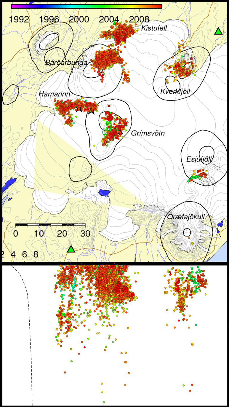
Image from the Icelandic Met Office, created by Kristín S. Vogfjörd. Showing selected earthquakes.
I am not going to discuss Kverkfjöll, Esjufjöll and Öraefajökull here. I am going to concentrate on the volcanoes on the Bárdarbunga and Grimsvötn fissure swarms. But, remember that the only reason we call these the Grimsvötn and Bárdarbunga fissure swarms are due to those two central volcanoes having the largest number of eruptions along the line. One could as well have called the Grimsvötn fissure swarm the Thordharhyrna fissure swarm since it is the volcano in the middle. It is all a point of perspective really.
First of all, let me point out that there seems to be very little to no evidence for the volcanoes being interconnected during the normal eruption times. They really act as separate central volcanoes. I am though not going to go into depth of the Gjálp conundrum in this post. That will have to be saved for another time, here I will just point out that there is no evidence for any magmatic movement between Bárdarbunga that had a large earthquake that is believed to have caused the eruption of the Gjálp fissure from Grimsvötn central volcano.
Bárdarbunga
We see that the earthquakes of Bárdarbunga are neatly centered around what most likely is the active magma chamber. A few earthquakes run down towards the depth, a sign of magma movement, but in a mature feeder that most likely is permanently open downwards, this probably means that most of the earthquakes before an eruption would be around the chamber. Please note that there are two small tendrils of earthquakes moving towards Grimsvötn fissure swarm. The smallest of these is rather insignificant, but the other leading towards the fissure swarm north of Grimsvötn is a bit of a conundrum. I do not have a good explanation for that one. It might be related to the rifting fissures of Iceland, but that is just a guess. I will return to this in the conclusion.
Kistufell
Most of you will notice that there is a very strenuous separation between the Bárdarbunga earthquakes and the earthquakes of Kistufell. At the same time there is no clear evidence of a connection between them either. Probably Kistufell is a central volcano in its own right and erupts separately; I guess time will tell on that one.
Hámarinn/Loki-Fögrufjöll
Most people see Hámarinn as a subset volcano of Bárdarbunga, but as we see there is no evidence of that in the dataset. To the contrary it steps out like a rather significant central volcano in its own right.
At the same time we have the Loki-Fögrufjöll volcano that is seen as a subset of Grimsvötn.
In the data we though see a completely different picture grow forth. Hámarinn is very clearly separated from Bárdarbunga, and the same goes for Loki-Fögrufjöll lateral fissure system being separated from Grimsvötn. Instead we see that Loki-Fögrufjöll apparently is a fissure volcano emanating from Hámarinn volcano (or the other way around). On the other hand there is a clear trend pointing towards Grimsvötn. And, at the same time there is a shorter trend running down towards Thordharhyrna volcano. I will come back to this in the end.
It is also well to note how active the feeder tubes has been at depth, a sign of heightened activity in the system during the timeframe of the dataset. Interestingly enough there are 3 clear deep feeders being active leading up to all 3 eruptive vents. To me this points toward a less evolved volcanic system then either Bárdarbunga or Grimsvötn, and at the same time with the potential of developing into a very advanced interconnected volcanic system with time.
Grimsvötn
Grimsvötn has been very active during this timeframe. It is the only volcano that has erupted among those we are discussing here, during the timeframe of the dataset it erupted no less than 3 times.
It is therefore surprising how little volcanic earthquake activity the volcano has shown. Almost all of the earthquakes have been around the chamber or chambers. Very little activity shows towards depth, a probable sign of a permanently open feeder system.
Conclusion

Laki fissure line.
As I wrote above, this is how it looks during normal eruptive times. I will though have to put in a caveat here, it is an assumption, we do not have data for how it looks when other volcanoes then Grimsvötn erupts. The most likely thing is that the picture will not change that much, we will only get more at the same locations.
Let us now look at the small enticing enigmas we found and how that might affect things during a rifting episode opening up a fissure swarm. First thing we have to acknowledge is that we know very little about this style of eruption. We have no dataset for an eruption like that. In reality we have at best secondary data or written records for the Lakí eruption. And from the Lakí eruption we only have the larger strokes, not the more minute details that happened.
What I find intriguing are the trail of earthquakes running from Bárdarbunga towards the northern part of the Grimsvötn fissure swarm, the Hámarinn/Loki-Fögrufjöll pointing towards Grimsvötn and the line running from Hámarinn towards Thordharhyrna.
We know that Thordharhyrna is a part of the Grimsvötn fissure line due to them having co-erupted during rifting fissure eruptions. We also know that there is a known mechanical link between Thordharhyrna and Hámarinn. And Hámarinn we know is on the same fissure swarm as Bárdarbunga.
I think that the central volcanoes work as weaknesses between the fissure systems, and that they during the larger rifting fissure eruptions tend to open transverse fissures between the fissure systems and each other. I know that this is a bit of a shot in the dark, but there seems to be a bit of evidence for the possibility in the dataset. If so it would explain a lot about where the huge amounts of magma comes from during a Lakí or Veidivötn eruption. Of course this in the end would have to be corroborated by hard data. But the idea is intriguing enough to mention as it is.
CARL


Thanx!! Very nice piece of information!
Another well written, informative and easy to follow piece for an amateur like me. Thanks Carl
My question is how often does Iceland have a fissure eruption or put differently put a MAR spreading event
About every 250 years.
But one should remember that it can skip over an event. And that all of them are not equal in size. Some of them are fairly small in size (well, relatively).
What drives them is the pent up energy as the continents drift away from each other, and it seems like the crust between Grimsvötn/Bardarbunga and Katla can not take much more then 250 years of accumulated strain before rupturing.
There are 230 years since last Laki event, this June. I think GL did calculate similar event happening about 236 years on average (quoting from memory). From Wiki ..
http://en.wikipedia.org/wiki/Laki :
”On 8 June 1783, a fissure with 130 craters opened with phreato-magmatic explosions because of the groundwater interacting with the rising basalt magma. Over a few days the eruptions became less explosive, Strombolian, and later Hawaiian in character, with high rates of lava effusion. This event is rated as 6 on the Volcanic Explosivity Index, but the eight-month emission of sulfuric aerosols resulted in one of the most important climatic and socially repercussive events of the last millennium.
The eruption, also known as the Skaftáreldar (“Skaftá fires”) or Síðueldur, produced an estimated 14 km3 (3.4 cu mi) of basalt lava, and the total volume of tephra emitted was 0.91 km3 (0.2 cu mi). Lava fountains were estimated to have reached heights of 800 to 1400 m (~2,600–4,600 ft). The gases were carried by the convective eruption column to altitudes of about 15 kilometres (10 mi). In Great Britain, the summer of 1783 was known as the “sand-summer” because of the ash fallout. The eruption continued until 7 February 1784, but most of the lava was ejected in the first five months. Grímsvötn volcano, from which the Laki fissure extends, was also erupting at the time, from 1783 until 1785. The outpouring of gases, including an estimated 8 million tons of hydrogen fluoride and an estimated 120 million tons of sulfur dioxide, gave rise to what has since become known as the “Laki haze” across Europe.”
And here are the 3 last events spanning slightly more then 1000 years.
Lakí (Grimsvötn) 1783
Veidivötn (Bárdarbunga) 1477
Eldgjá (Katla) 934
You forgot one recent one series of events:
1862 in Bardarbunga fissure, towards the northeast and at the edge of the glacier.. It was smaller than Laki but still a major rifting eruption and rifting event.
Few years later, 1874, the big rifting event starts at Askja. Also a large long fissure, few months later followed by the large caldera forming eruption.
Another very big one occurred circa 783. The Vatnaoldur eruption, just another very long fissure next to Veidivotn. Now comes the fun part. Before that eruption, a very large lake existed in the area of Veidivotn, a lake larger than Thingvallavatn, and that lake was then the largest one in Iceland. Then, the fissure opened and the Vatnaoldur event lifted a huge amount of ash. So much it completely covered Iceland and now known as the settlement ash.
When Veidivotn erupted, there were still the left overs of the original lake. The Veidivotn event was still very ashy but less than Vatnaoldur. The lava eventually filled the lake and only small lakes survived, which are still there today.
Laki also erupted in a spot with much groundwater and lakes around.
Thanks Carl for another amazing post, full of details and lots of follow up.
Great post. I’ll come back to it later, for I must leave now.
Icelandic volcanism never ceases to amaze me!
Thanks, Carl! 🙂
Thank you Carl, this is a whopper of an article, it will take me a while to digest 🙂 I have to say, I am proud of you all here. It is like an Open University of Popular Science, the only difference is, that not professors put their research before us but, that we have to search for professors to “milk” them for any bits of their science they may have put on the internet. My remaining wish for this blog is to find a resident volcanologist who would put in a note here, a correction there and the one or other bit of new findings as far as his/her time allows. I just love volcanocafe, thank you all!
Actually we have Rudiger Escobar Wolf who is doing his ph.d. on the Guatemalan volcano of Fuego. He has promised to A) proofread my second instalment of A Tale of Three Cities, and to write a piece on his beloved Fuego.
I think that if we could just ask him nicely enough he might write a bit more as time goes by.
Thank you all for your kind and warming comments!
They are very appreciated. And it was a whopper to write too…
I am trying to write a bit “deeper” things now, so it takes longer time to write them. So I hope that everyone will try to pitch in a post now and then. Perhaps you could write a post on your favourite webcams? 🙂
My favorite webcam is not compatible with Windows 7. I had stripped it our of it’s housing and rigged it to fit the eyepiece of a telescope. Dunno why. The trees around here make sky looing a pain in the arse, and you can’t see the beach from here. For a while, I had a program that allowed me to stack images and save the results out in FITS format (commonly used for astro work) but alas, that program is also not compliant.
So… my favorite webcam idea is a no-show.
looking at the depth on the bardabunga tendril those quakes seem to go deep
I’m wondering if someone can figure out if there is a way to ‘pull out’ the swarms from that tendril (and any other interesting tendrils Carl mentioned) to look at them in relation to the other volcanic swarms – perhaps colouring them on a rotating plot ?
Hello, if you look at the link to the original pdf you will find images that show that those deep quakes are in 3 feeder coming from Hámarinn/Loki-Fögrufjöll.
Lurking have the complete list of earthquakes and could do this, and have done so before. Problem is that we do not have a list of the volcanic earthquakes used here. So I think this might be a very hard plot to manage. But who knows what Lurking and the other plotters can pull off, they have done miracles many times.
Rotating plots for me, are a pain. The other plotters have managed to automate the process. Mine is manual.
And now, an example of a tragic news report that I had to stop and think about for a moment. (not a tragedy for me, but for some family out there) A bicyclist was killed on Garcon Point Rd. The Highway Patrol is “still investigating.”
I do not understand the “still investigating” part of the news report. Garcon Point Road runs down to the Garcon Point bridge. Garcon Point is a low lying area with scrub trees and quite a bit of low-land. It fogs easy when the weather is right. The road is two lane, with no lighting what so ever until you get to the toll plaza or up to the Interstate. The accident occurred at about a quarter after one AM. No indication about looking for the driver that hit them, and no info about a DUI arrest. Maybe the driver was hospitalized and they are waiting for blood tests, but base on what I know of the road, and what was said on the radio.. it is probably a case of a not too bright cyclist wearing dark clothing. Not to demean the death, but people just do not comprehend the value of light colored clothing. I had one guy wearing all black scare the crap out of me on the road in front of my house. It has streetlights, but I didn’t see him until I caught the glare off the back of his neck from my headlights. I thought for sure that my mirror would have caught him… but no tell tale “thunk.” (I’ve hit a pedestrian before, and know the sound well. The police cited her for drunk in public and jaywalking).
Anyway, I found the news report pretty odd. “Still investigating”
BTW… that pedestrian I hit. I didn’t actually “hit” her. She put her arm out to protect herself and wound up stiff-arming my car as it came to a rest. I had gone sideways trying to stop and the final lurch of the car on the springs is what pushed her over. Not only did she get cited for drunk in public and jaywalking, she refused treatment from the ambulance crew.
One of the more scary events of my life. I imagine it would have been for her too, if she were not drunker than shit.
They investigated that one too… event got out a gizmo and walked off my skid marks to see if I had been speeding. (drag coefficients and vehicle mass can yield the speed from the length of the skid) I was 5 mph under the limit.
This reply is probably too late for you to pick up, but I sympathise totally with you. I used to drive a winding little English country lane with steep dips and twists not far from a town centre near London. Picture this: it’s night. A fog is forming in the hollows and I’m taking care. Then out of the fog what do I encounter? A black horse, a rider dressed in dark clothes, carrying a pathetic little torch that would not light up a keyhole from one foot. I’m glad I wasn’t driving like many of the folks do around here. Scary as hell coming across that out of the fog.
Not too late. Scary.
Speaking of scary, one night I got pissed, while pissed. I decided to walk home. In Jersey.
Its not the locale of the tale, but the road I wound up on was “Sleepy Hollow”. It goes through a graveyard. It was October, and the air was crisp. The only thing that made me not give up was the beer I had consumed.
By the time I got home, I was sober, cold, and creeped out. On several of the headstones, were these little blue, or red candles.
Lets just say that it didn’t help my nerves.
Thank you Carl for this very informative CV of the volcanoes under Vatnajökull! If Tolbachik should be the culprid for our cloudy winter and spring I don´t want anything like Laki happen these days.
dfm recently made a nice 3D plot of the area for 2011 and 2012:
Us plotters all use the same earthquake list (the listi files extracted and kindly shared by GeoLurking). There is no way for us to select events like Kristin Vogtfjörd, because IMO does not provide the location (longitude, latitude, depth) errors for the events. She selected the best localized events (lat, lon error <0.5 or 0.2 km; depth error <1 or 0.5 km) to have a good view on feeder tubes or faults or whatever. There might be more complete data hidden in journal papers like those I recently encountered for Hekla which come with rms, azimuth and such.
Hehe, hiding candy all the way up here.
Very nice plot 🙂
Something that I am normally a bit usefull at is to go and kindly ask for things like that from people like the IMO… About half the time I actually get what I ask for. I will see if we are lucky this time (I should have thought of doing it before, but since I do not plot due to my codiotness…)
That surely would be nice of them…and you. It is fair enough they have these 290,000+ events online, I can understand that they reduce the traffic load by limiting them to the basic data (time, location, magnitude).
It is very fair of them.
Because if they started to have all the info available there is actually a very real risk that the Internet for all of Iceland would go down as Volcanoholics stormed in. Or at least blew the vital back line servers to smithereens.
I think they might share the data though, as long as it is not being used for an active research project.
I will get back to you as soon as I have an answer.
Lakí (Grimsvötn) 1783
Veidivötn (Bárdarbunga) 1477
Eldgjá (Katla) 934
Curious, what are the records of fissure eruptions prior to 934? Have any of these fissures erupted multiple times? If we’re assuming a 236 year average, there has to be a larger sample size, right? As is evident from the span between Eldgja and Veidivotn, it would seem the 236 year estimate is just that – a rough estimate of probability.
Also – it’s been said that Laki was possibly the greatest natural disaster that has ever occurred when you account for disease and crop failure around the world which was indirectly attributed to climactic effects of the eruption.
Is there similar evidence for dry fog, temperature drop, famine, and other climatic anomalies during the Veidivotn and Eldgja eruptions (which I believe were supposed to be even larger than Laki)
There are a lot coming from Bardarbunga, and at least another from Laki. And there has been 2 more Katla fissue events.
But the biggest is the Thjorsahraun eruption from Bardarbunga weighing at around 15 cubic kilometers.
It is just that the list is hard to get now from GVP.
Yes, largest events were Thjorsahraun (Veidivotn region, 8000 years ago), followed closely by Trolladyngja (also Bardarbunga, but to the NE of it, biggest shield volcano in Iceland).
Then, also the other two very big shields in Iceland. The massive lava flows at Theistareykabunga and Skjaldbreidur, south of Langjokull.
All were in the range 10-20 km3 lava, possibly up to 30 km3.
But let us not forget some Hekla and Oraefajokull events had up to 10 km3 DRE. And some eruptions in Reykjanes, Hengill and Langjokull also reach close to 10 km3.
Compare this with 0.7 km3 Grimsvotn 2011 eruption and 13 km3 Laki eruption.
6 events are known in the last 5000 years or so, comparable to Laki and Veidivotn, at the Veidivotn fissure region, before the 1477 and 783 eruptions. It seems the region erupts every roughly each 700 years.
Then, add at least 2 Laki region Laki-sized events, southwest of Grimsvotn, but those events were quite thousand years ago. Apparently Laki region eruptions are rarer. Every few millenia.
Edlgjá events: I only know about the Holmsá, also circa 5000 BC. So Edlgjá region events are quite rare.
I would expect next very rift event, either near Veidivotn or Kistufell, because they are rather geiologically more common, or otherwise somewhere in an unexpected location.
Previous large fissures in recent centuries occurred at the Langjokull volcano, Reykjanes, Askja, Krafla… Which spot had no such event for a long time?
I know some spots: Fremrinamur, Kverfjoll, Theistareykjarbunga, Thingvellir…
Carl: an excelllent, insightful and accurate post.
Youa re correct with Grimsvotn having little quakes due to its permanently open feeder system. Its almost like Hekla. Anyways, both are the most active erupting volcanoes in Iceland, in recent centuries.
Also, because Laki occurred, and also Veidivotn, then we likely have a bubble of hot magma permanently under those regions, and hence we do not see any quakes there. Except just before an eruption and probably shallow and quite notorious ones.
Gjálp: the fissure eruption occured just after a major quake in Bardarbunga, a M5, and a weird quake because no sign of tectonic or magmatic movement was observed. However, the fissure was also closer to Bardarbunga than Grimsvotn, and in my opinion this was in fact a lateral dike of Bardarbunga that triggered some nearby magma of Grimsvotn. It is the small line of earthquakes that you see from Bardarbunga running in direction of Grimsvotn; the spot of Gjálp eruption is just at its end. 🙂
The north line I do not know, but it seems a dike that never erupted. Perhaps a candidate for a possible site of a future eruption.
In another way, Hamarinn seems to link, at least earthquake-wise with Grimsvotn, or perhaps the other way around. No clear idea about it.
On Laki: I read the historical records, but I can’t remember them quite well now. I know Grimsvotn erupted before the major Laki eruption, apparently, if I am not wrong. And Laki started with major earthquakes in the region for an entire month (May), while I guess Grimsvotn was erupting by then. Then, in June the eruption on Laki starts. But it got larger a couple of weeks later, after a new period of strong quakes. So at least there were two bursts in Laki, but Grimsvotn was erupting before and after that (from what I heard into 1785). Clearly things are not very accurate from historical records. Even more surprising is that earlier in May 1783, a large ashy eruption also occurred in Reykjanes! And a few months later, a M7 quake in Thingvellir. That was a hell of a year in Iceland.
I am going to write a post one day regarding the Lakí eruption based on more accurate data than the normal sources. But that one will be one of those in waiting since it would require quite a lot of substantial sorting of the data for me. And in parts also getting permission to use unpublished data that I have access to, and before I have that permission I can’t write it.
Let us just say that I could publish a paper in a journal from that data and it would hold.
Cool!
If you can, mention on the earthquakes that occurred before the Laki event. There is not so much written on that, but it sounds interesting. Also, on the other ongoing eruption of Grimsvotn at that time.
Sorry, I can’t do miracles. The earthquakes are on their own. There is just no physical evidence from them to examine by now. Grimsvötn itself is also hard to do anything with real data on since the lavas there are hidden.
I can not say what I will write now, have to wait for permission and then you get the post instead 🙂
Well, this post is a kind of miracle. It was such a great job.
Anyways, I would love to dig in Grimsvotn, but its a far away glacier, and going there requires becoming very close friend and linked with the people that travel there, mostly scientists and crazy adventurers.
I might be going to Oraefajokull in soon though. Much easier to go there.
I 2nd the “cool” statement. I think I can work out a reasonable magnitude estimate if I had locations where the quake was just “felt.” by going backwards in formulas in the Atkinson-Wald “Did You Feel It?” paper. That’s how I came up with mid Mag 5.0’s for the Laki quakes. (if I remember correctly.) and a Mag 5.0 in Normal Mode faulting comes up at 2.75 km down-dip rupture width and a half meter displacement from Wells-Coppersmith.
From what I read in other papers, that’s pretty much the displacement that Laki caused. Veidivotn and Edlgjá were a bit larger displacement, the 1862 event just a few cms.
Do you have the actual stated opening widths? I could do some comparisons to come up with a Normal Mode faulting quake size guesstimate.
Good morning everyone,
That information was in a paper I read last year, but the pdf its on laptop that got burnt.
With some research, we should be able to find that paper again. In the study, the authors measured the displacement in cms for each dead zone eruptions.
And remember do not store papers about Laki on laptops, the computer might get burnt with so much lava volume 😉
Interesting… according to download of eruptive events from GVP, the -5000 year Bardabunga event had a lava lake.
Oh if only ! A smile there to start the day.
Carl have you ever thought of taking up teaching or lecturing? Thank you for a post that is easily understood even though the subject matter is very complex. I am sure the nature of the VC posts are an important factor in our large readership. They are accurate, precise and jargon kept to a minimum. They are a good basis for students to start widening their knowledge.
This post I found so readable. It drew together the bits of information I already understood to provide a very rounded view of the systems in South East Iceland.
A passing rumination as I finish coffee #1………..Going back to the Settlement time…..
can you imagine the newly arrived Icelanders? Each person had their reasons to emigrate. Can you imagine their reaction to the many major volcanic events at that time? Did they flee westwards to find Their Land of Dreams? Did they go back to mainland Scandinavia? Nope. They stayed and dealt with it. Hence the stoic and practical Icelandic citizens we see today.
I love Irpsit and Islander’s comments. They are our eyes that see Iceland day to day and remind us of the very human emotions and factors associated with volcanic events.
Well done Carl, and everyone that makes VC a “must visit every morning” Blog
Thank you Diana!
It is the worst kept secret in the world… but yes I have been teaching, about 3 meters from where I am currently sitting at the HumLAB (Humanities Research Center, University of Umeå). It is a fantastic place, Spica would love it, and have probably heard about it. Having free access to a Digital Research Lab and a University Library 50 meter away (actually right on top) is a boon when doing any writing.
Now I will go back to trying to read up on poor Fremrinamur for next weeks post by me. Unless of course I get sidetracked once again by something more interesting.
BTW… that Hamarinn to Grimsvotn swarm has its bottom deep in Hamarinn and angles upward the closer to Grimsvotn that you get. I’ve plotted it before. Can’t reproduce it now, I’m using the phone since I’m hoping to doze off… as soon as I can get my head to quit thinking of stuff.
If you look at the pdf there is a fairly good plot a page or two later than the two plots above that I with heartfelt gratitude stole from IMO and the eminent Kristín S. Vogfjörd.
Since it is 30 degrees C here today my head is swarming with thoughts about remote cooling.
http://hraun.vedur.is/ja/oroi/ask.gif Askja
http://hraun.vedur.is/ja/oroi/dyn.gif Dyngjulhals
and http://hraun.vedur.is/ja/oroi/grf.gif Grimsfjall
This post explains the possible volcanic activity that are causing these graphs, that show almost constant magmatic vibrations.
Or am I off target?
Also I meant to point out that there is a North – south line that runs from Askja to Slysaalda along the western edge of Vatnajokull where the IMO SILs show this constant “Humming”. If you look at Grimsfjall, that shows the activity below is constantly restless and now in the last two years these other SILs have started showing similar activity
Yes, Grimsvotn is always noisy. Magma is probably always on the move there 🙂
Anyways the place has intense geothermal activity and eruptions every few years,
If that restless is extending northwards (when exactly did the change got place Diana?), this might man hotspot magma is migrating northwards.
We know well how the restlessness in Askja started several years ago, in 2009 if I am not wrong. Inflation, deep earthquakes, last year the lake unfrozen, etc…
This could mean fresh magma is moving there, at great depths. If that is so (and I dont know when it happen this change), then, we should see new dikes or eruptions within the next months.
I predict a fissure there is going to be small, if it occurs at Askja. (Just like in 1961) If it occurs somewhere south of Askja, then it might be larger because it is longer since last rifting there (last one in 1862)
Hello Diana!
It is you who should start teaching! Your question put the finger exactly at a spot I have been thinking a lot about. On the northern line we have 4 volcanoes, two of them inflating (Askja and Theistareykjarbunga), one that is dormant (Frerminamur my nemesis) and the deflating Krafla volcano (with occational short bursts upwards, but in general deflating).
Ontop of that we have Upptyppingar that has had bouts of hard inflation, and might be a central volcano on the Kverkfjöll line (if memory serves) and the inflating Herdubreid that might be on a transverse fissure of Askja, or perhaps is a central volcano of its own, or a mix of Askja central volcano.
I am rambling…
There are two things that correspond in time with the activity you have spotted. First is Theystareykjarbunga that started to inflate 2008 and begann seismically active (volcanic earthquakes) in 2010 (the hum came abouts then as have since then spread as you said). The other one, and I believe more likely, is Herdubreid. It also started to inflate around 2008 (might be wrong on the year and it could have been even earlier) and the quake swarms came in 2010.
That is why I wanted us to do the Herdubreid research program. Because I think we might get an eruption there some day, and in worst case that could be a larger eruption together with Askja (worst case scenario).
GeoLurking: I found the paper you need. http://www.seg2.ethz.ch/jonssons/jonsson_evrz_jgr1997.pdf
Here they estimated the displacement during the Laki event (around 4.5meters), Veidivotn (10 meters) and 1862 dead zone eruption (1.5 meters).
Basically they state that rifting,m from Hengill northeastwards , is divided by the Thingvellir(Langjokull region, and the eastern volcanic zone. It’s as if rifting occurs around 90% in Reykjanes and 10% in Westman Islands, 70% in Hekla, and 30% in Thingvellir, and then around 10% in Langjokull and 90% in Bardarbunga. This is their idea.
As we move northwards, rifting becomes solely focused in the east volcanic zone, somewhere near Askja.
Assuming a 1.9cm/year rifting displacement, in the dead zone, they estimate the dike width of each event. And also the lenght of the fissure is known.
That same information is also here
Click to access Iceland2005.pdf
And here is another nice read, on similar topic
Click to access jokull58-einarsson.pdf
They speak on this one, on the angle of rifting for each region of Iceland, something which is often forgotten…
A large swarm of appreciations!
Very informative! Nice to have the background info when I actually have been on the spot 🙂 If you are interested, I can send you some bumpy film sequences from Katla, Grímsvötn and Vatnajökul. Cheers Christian
Yes, please do it, Christian.
You could write a post upon those sequences, how about that?
Brilliant idea from both Christian and Renato here!
I would love to read and watch that 🙂
🙂 Thank you Carl, to whom do I send the material?
I have to edit the film material to 1 sequence then. Exciting 🙂
Thank you for the idea Renato! I’ll be back 🙂
Thanks Carl for this greatly enlightening article.
The picture from Laki is stunning.
On another subject Tolbachik seems still to give some nice lava flows. I know the link has been provided before (by Shérine I think), but there are new posts on it and one of the videos makes you listen to the noise of a lava flow.
http://lusika33.livejournal.com/39246.html
Actually it feels like Tolbachik would merrit at least one article more in here.
It is the most interesting eruption in a long time, and I am seriously scratching my noggin’ on this one without getting any grips on it…
My only question… Who would love to write about it? Or perhaps whos woulds likes to writes abouts its? (pluraly befuddled today) It is interesting enough for more then one post (I admit to being greedy)
I have some free time at the moment. If no-one else wants to write up Tolbachik, I’ll have a go.
But I think Sa’ke may want to do something as he is busy doing some research 😉
She actually, but i’m not really comfortable enough with English to write a post. Unless you want it in Dunglish.
Sorry for saying “he”.
no problem
Hi sa’ke, and All…
If you want to do it I have had some success with “cleaning up” swedelish, germlish, schpanglish, americanlish and a variety of of english/ foreign hybrids… Gibraltar schpanglish is fun!!! Subject to yr final approval o’ course x
If you have worries, I am native Dutch and I can type it such that Schteve or Ukviggen can make it exactly as it should be in proper English. If you want, and you have something that is already proper Dunglish, I’m sure they can check and make it look awesome 🙂
I found some interesting papers about Tolbachik:
Following this one (http://connection.ebscohost.com/c/articles/70162430/new-data-deep-structure-northern-vent-great-tolbachik-fissure-eruption-1975-1976) Tolbachik has two magmachambers: one at 2-3 km depth and another at 7-8km.
Tomographic Images of Klyuchevskoy Volcano (www.unc.edu/~leesj/FETCH/Papers/GM01015CH21_lees_kliuchi.pdf
And this is a preview of a book about Tolbachik from google: http://books.google.be/books?id=nnon6boqRpkC&pg=PA96&lpg=PA96&dq=tolbachik+eruption+paper&source=bl&ots=NDvOfoFyip&sig=NVhcsTe6GRteBCylDbY4NsiuPfM&hl=en&sa=X&ei=Ai2nUYihOs-Y0AWq2YDoDA&ved=0CDEQ6AEwATgU#v=onepage&q&f=false
If I understand it correct. Tolbachik is a central volcano on a fissure. On the same fissure you have also the central volcanoes of Shiveluch and Klyuchevskaya. http://tinypic.com/view.php?pic=263j9ee&s=5.
This means that this group are volcanoes created by a MAR-like spreading events. Is this the only group of volcanoes in Kamchatka associated with rifting? I thought that all the volcanoes over there were subduction volcanoes..
I guess you are correct, but still no expert here. These are all subduction volcanoes and I was about to ask the same question: how come such subduction volcanoes in Russia or Chile (Villarrica) spew basaltic lavas, i.e. behave like rifting volcanoes, I mean, they are all stratovolcanoes aren’t they?
I am not sure if you can consider a “fissure swarm” the sort of volcanism in Kamtchatka, that’s what I meant.
“… i.e. behave like rifting volcanoes…”
Beware the back arc basin. They from from rifting style mechanics as magma wells up from where it percolates off of the re-melted slab. Kamchatka has arc volcanism going on, but the stage is set for a rifting mechanism to come into play are there… it’s just lurking in the shadows…
And, remember that Kamchatka has lots of teranes smashed into it. Where they are not fully sutured will be weak and prone to letting stuff up and out. In general, the weak boundary will be aligned with the peninsula.
Tolbachik’s magmas are primarily generated by the subduction of the Pacific Plate. Basaltic lavas can occur in subduction zones.
@Carl, thank you for post. Enjoyed reading it (eventually, after struggling with internet connections etc !)
Weather improved significantly in Copahue. No signs of eruption and according to yesterday’s report seismicity has waned a bit, but still red alert level 1.
And for the EB readers there’s a new provocative blogpost about earthquakes and moon cycles. I guess Erik wants to summon all loons and trolls back to his blog… 🙂
Poor Erik…
We should all send blissfull thank yous to Lurking for being such an excellent loon stomper on this subject. For some reason they do not last long when he brings out his big guns of plottingness.
As Ruiz Gil wrote, the magma is on the loose, but it might take an unspecified time to materialize at surface.
Poor Erik? Nah, he has a +4 loon smacker in his scabbard. I like that he lead off with a faker and then showed the actual data later… which looks pretty much the same.
Well, false alarm.
Erik now issues a follow up of his previous post all about the human ability of “seeing patterns” – very interesting indeed!
http://www.wired.com/wiredscience/2013/05/earthquakes-patterns-and-predictions/
Yes, and it was very interesting. I put in a link to Lurkings majestic moon and the moonie post over there.
https://volcanocafe.wordpress.com/the-moon-and-the-monie/
Well, according to some, all hell is gonna break loose by the 2nd June. They have also stated that it if doesn’t happen, “whew!” I like their methodology of coming up with it, and their caveat of “maybe not…” The physics side, and what amount of energy would be needed to achieve this calamity, not so much. Even the thing that made the Siberian Traps did not fracture the Eurasian plate during it’s formation. Igneous provinces like that don’t happen from a small expenditure of energy. It had to be ultra massive. (And high in Iron and Vitamins too!)
I think that, if the moon has an effect on volcanoes, even a very very small one, you have to look to the 18,6 year cycle of the moon. The plane of the moon’s orbit is by 5° inclined to the ecliptic (the plane of the sun’s orbit). This makes that while the sun’s declination every year changes between -23,5° (midwinter) and 23,5° (midsummer), the declination of the moon makes in its nodal period (27.212 days) vary within the 18,6 year cycle. At its minimum the moon declination is tween -18,5° and 18,5°. But at is maximum the moon’s declination is between -28,5° and 28,5°. These maximum and minimum are called lunar standstills and last for nearly three years. https://en.wikipedia.org/wiki/Lunar_standstill
This 18,6 year circle is also observed in the sea-tides. The interesting part is that at the major lunar standstill, when the moon moves between -28,5° and 28,5°, the full moon becomes circumpolar above 60° N in the summer months. This means that the full moon will not rise above the horizon. But in the winter the moon will rise higher above the horizon than the sun ever comes (28,5° vs 23,5°). If the moon has an influence on volcanoes, this have to show clearly above 60°N and in a major standstill.
Done that.
Data set – All USGS quakes M 4.5+ 1975 to 2010 vs Lunar Declination.
From:
https://volcanocafe.wordpress.com/the-moon-and-the-monie/
Caveat: I only looked at quakes. I didn’t have a listing of all eruptions worldwide and what time they occurred.
I’ looking it up right now for Iceland. If you look at this list ( http://en.vedur.is/earthquakes-and-volcanism/articles/nr/1874 ) I could only find 2 eruptions (Hekla 1970, Austan Hekla 1913) during a 3yr period for a major standstill. This means the year of the max declination (2006-1987-1969-1950-1931-1913), the year before it and the year after it.
Don’t get too much in a hurry, I can’t even touch it now, and I would have to convert it all over to something I can feed into the Ephemeris program to do the query.
My focus right now is getting these tickets done and getting a motor delivered to my mechanic.
Well, that’s the deal isn’t it? If there were an effect, there should be some modulation in the occurrence interval of the quakes. Similar to the way an audio signal phase modulates a carrier signal generating FM radio. Thinking along that line, one method for exploring it would be to look for lunar related signals by using a sort of quadratic detector. Not sure how to implement that yet.
Effectively, it would be FM modulated noise and not a base carrier frequency.
My non-expert 2 cents worth:
USGS data set is EQs greater or equal to 4.5.
Moon’s gravity is quite weak so if it did have an effect it would cause or impact smaller EQs.
Might be difficult to see a link in the USGS data set.
asteroid 1998 QE2 almost close to earth now and it has a moon also, no kidding, read all about on
http://science.nasa.gov/science-news/science-at-nasa/2013/30may_asteroidmoon/
don’t forget the sun, has a large coronal hole it will hit earth about the 2-4 June
I thought about this somewhat – and I think my comment is somewhere in response to Lurking’s previous moonies post, but as I can’t find it here’s the quick version.
1) assume moon has an effect
2) assume moon ‘nudges’ proto earthquakes over the edge
3) assume moon effect is biggest on a particular day
4) notice that the world spins
5) notice that the moon alignments would be almost the same the day before but a tiny bit less
6) assume any given proto quake needs a size X nudge
7) assume there are lots of proto quakes available needing different size X nudges
8) on a given day there is a size X effect from the moon – a magnitude 1 quake is triggered
9) on the next day the moon effect is slightly more – another mag 1 quake is triggered
10) at 13 days before the lunar maximum a mag 7 quake occurs, was that because the ‘nudge’ was just bid enough on day 13 – or was it completely unrelated.
I think you can never tell – and thus there can be no pattern
or if you’re looking for a big quake to happen at max lunar effect – why didn’t it fire off the day before when the lunar effect was ‘almost as much’ – and why does the quake need 1 cheeseburger’s worth of energy – rather than 5 cheeseburgers (or any other arbitrary amount) of nudge for it to start
oh yes missed out number 11
if the quake 13 days before the ‘lunar max effect’ was because the lunar nudge was big enough
why didn’t it happen the month before when things were only slightly different
Funny enough, I just finished the latest book by the linked-to Mr. Schermer on all these pattern and belief goodies. The book definitely makes you wonder.
Do I see a “plume” forming at Copahue?

That cloud that ends in some sort of Jaguar head looks a bit ominous. But, I am not seeing a ash column. Could though have been a minor pyroclastic flow or landslide. Probably a landslide since a pyroclastic flow would kind of need a full blown eruption to form.
definitely a bit of steaming coming out of the crater now. But no ash.
There seems to be a puff of smoke, that is slowly fading, could very well be jus another cloud, a bit dark one though..
And at the same time at another place:
Pacaya is rumbling with a small eruption.
http://www.insivumeh.gob.gt/geofisica/vulcanologia/especial.htm
I took the liberty of asking Rudiger Escobar Wolf to write a short post on it. Hopefully he will oblige. *please!*
Edit on myself:
Rudiger has agreed to write a post on it as soon as he has gotten more information.
BTW, Carl. Congratulations. Your tropopause popping Grimsvotn plume has supplanted Puyehe Cordon-Calle as my background wallpaper. I’ve passed up supermodels and other inane wall papers in order to keep Puyehe… but Grimsvotn… now that is a looker!
An awe inspiring sight!
Yepp, Grimsvötn knows how to do awesomeness.
Currently I have Tolbachik…
Interesting. I looked to the last eruptions in Iceland and when they occured in the 18,6yr moon cycle. (see discussion above)
In the 3 years of a maximum standstil: in total 2 eruptions since 1900
2005-2007, 1986-1988, ’49-’51, ’30-’32 : none
’68-70: Hekla in 1970
’12-’14: Austan Hekla
In the 3 years of a minor standstill, in total 11 eruptions:
1998-1996: Grimsvotn (’98), Gjalp (’96)
’77-’79: krafla (2 times in 77)
’58-’60, ’40-’42 none
’21-’23: Askja (’21, 2 times in ’22, ’23), Grimsvotn (’22)
’02-’04: Thordarhyrna (’03), Grimsvotn (’02)
In the (6,3 year) period from major to minor standstill, 10 eruptions
2008-2013: Eyjafjallajokul (2010), Grimsvotn (2011)
1989-1995: Hekla (’91)
1971-1976: krafla (’75), Heimaey (’73) Landeyjar (’73)
1952-1958: none
1933-1939: Grimsvotn (’33, ’34, ’38)
1915-1920: Katla (18)
In the (6,3 year) period from minor to major standstill, 15 eruptions:
1999-2004: Grimsvotn (2004), Hekla (2000)
1980-1985: Krafla (’84,’81 2times), Grimsvotn (’83) , Hekla (’80)
1961-1967: Surtsey (’63-’67), Askja (’61)
1943-1948 Hekla (’47)
1924-1929: Askja (’24, ’26, ’29), NE of Eldey (’26)
1905-1911: Thordarhyrna (’10)
data from http://en.vedur.is/earthquakes-and-volcanism/articles/nr/1874
For anybody interest 🙂 : “Austan Hekla” is actually the Lambafit eruption of 1913, that was 15 km “east of Hekla” (isl. austan Heklu), that was not an proper Hekla eruption, as it lies outside of Hekla area and fissures. Otherwise in iteresting tabulation, not that I know nothing about the Lunar cycles. Only “see” the earth tides and see the tides in the harbour and also offshore here, several meters on any given day.
See Carl´s “Deconstructing Hekla – Hells Gate Revisited” on this Lambafit and found it be “Katla lava” in composition. I think this is closest Katla get to Hekla!
Nice having such posts in the “Lager” (in stock / store room for engl. speaking ones).
https://volcanocafe.wordpress.com/tag/lambafit/
And Sa´ke, Madam (think nice French Lady here, please), your English is as good or more better than most of us commons here! But is only vise have one other (minimum) person read-it-over for edit, or correct grammar if needed.
@KarenZ & Sa’Ke:
Why not do two posts? I have the feeling that you two would write sufficiently different posts to highlight slightly different angles of the volcano.
And Sa’Ke, your Dunglish is really understandable, so do not worry about it. If you wish one of the admins would probably love to help out with a spell and grammar check as we edit it in.
Just my two cents!
Drive by tweaking… 😀
OK. Starting to write one. Expect something in the next couple of days.
@Irpsit, you know that Volcano of yours that I have told you for 3 years in uninteresting? Turned out that you where right and I was wrong all the time. Complicated little one, and the uplift is large (as you pointed out about 100 times).
I would have saved 3 years if I had listened 🙂
-I posted this on eruptions in response to Eriks’ post, but figured I would copy it here. It’s in response to predictions vs. probability, and how geological predictions can go wrong.
I think the problem people encounter with predicting patterns from large datasets is that they misinterpret probability for prediction.
Statistics is a pretty mindblowing concept when you get down to it. You can extrapolate and find advanced and hidden connections, and make a surprisingly accurate statement out of a set of data. Television ratings in the United States are calculated by a sample of under 10,000 people, and the ratings of that very small sample proves to be an extremely accurate model for the entire country.
There are two problems that geological probability concepts encounter:
One is the fact that what happens below the crust is not a controlled environment. You can’t make an assumption that the factors that contributed to the previous patterns will stay the same. What happens when the spreading rate at the mid ocean ridge suddenly speeds up? What happens when a subducting slab suddenly starts to subduct at a steeper angle? These changes in the overall environment can change the manner in which volcanic and tectonic processes occur, and suddenly the pattern that was relevant to the previous 10,000 years of activity no longer applies.
Second, as with any statistical analysis, patterns with extremely complex environments and tons of variables represent confidence intervals, not accurate predictions. People just need to separate confidence levels and the idea of probability from prediction. There is a big difference between saying “there is a 95% chance an earthquake will occur in the next 100 years at “x” fault line” and “There will 100% be an earthquake on march 21st, 2013 at “x” fault line”.
This is why most major geological studies on fault lines give probability scales for large earthquake faults. It doesn’t attempt to predict when it will happen since that would be nearly impossible. However, you can get a good idea on the odds of said event occurring, which makes preparation and mitigation much easier.
With everything said, I say let the loons be loons. If people want to convince themselves they somehow can predict earthquakes or volcanic eruptions, then let them be deluded in doing so.
Very nicely written Cbus.
You can thank William Sealy Gosset (aka “Student”) for that, and his employer Guinness™.
Guinness needed a way to evaluate the raw material for their operations in order to yield a consistent product, Gosset worked out the methods of taking the sample data and determining how it applied to the population as a whole.
in other words, you can have a statistic saying exactly what you like it to say
A comment attributed to Mark Twain>> there are Lies, Damn lies , and statistics
It really depends on how they are used. The scam stats that Twain refers to, usually come about by inundating the target with cryptic language that is difficult to understand or refute due to a lack of knowledge of what the speaker is talking about.
This is why it’s important to understand statistics… so you can call the speaker on the bullshit numbers that they are spewing.
Volcanoes are an excellent example of this. I have yet to find one volcano that follows a schedule. None of them are “overdue” (same for quakes). But over a period of time, they will tend towards an average repose period (unique to the volcano) that stands up over several thousand years of geologic record.
It’s not a matter of stats being lies, it’s a matter of how they are used. As a prop in a shell game, or as a tool to understand a process.
Processes. There is a hamburger place that I eat at from time to time. On a whim, I measured and recorded the length of every french fry that came with my order. (I was having a bad road day and needed the distraction) What I found, when I plotted out a histogram of the data, was a pair of peaks in the plot. Reflecting on this, I came up with the notion that the two peaks indicated that the place had two distinct potato sizes that they used to make the fries. Large and small. Before I did that, I had no idea that they did that. It may not be intentional on their part, but that is what the data hints at.
Or they were using Russet potatoes ,they have a tuber shape long round if they go through the cutter in a random distribution some sliced long ways some across the short side the result would be a split between long and short fries. i agree with you on the value of statistics ,when used properly unfortunately they are entirely too manipulable ,ie the bureau of laborer’s efforts BLS unemployment stats ( BLS>bureau lying statistics)
I think that hints at potatoes sliced by machine, some sliced lengthwise, others sliced sideways 🙂
At the same time, still nice strong going Tolbiachik: http://www.qicknews.de/Webcams/Tolbachik.php
BBGN
Is it just me that have missed the eruption column?
I did not know there was one. I have seen the lava lake, the basalt flood, and the strombolian vents. But not a column going up into the sky…
Judging by the height of the volcano in the foreground and the cloud level base it seems to be around 2500 meters straight up when it enters the cloud layer. Rather vigorous, I guess this will up the VEI-count.
Yepp it was me who missed something.
Back in december there was a 4km ash column. Seems like we have another one of that height today.
Tolbachik: initial report of the 2012 eruption 21/11/2012:
“KVERT reported that episodes of volcanic tremor were detected in the area of Plosky Tolbachik during 7-10, 18, and 26 November. The number of shallow volcanic earthquakes increased to 250 on 26 November. A strong event occurred at 1652 on 27 November. The Aviation Color Code was raised to Yellow. That same day observers from Kozyrevsk (40 km NW) and Lazo (50 km SW) villages reported ash explosions and lava flows at Tolbachinsky Dol, in the same area as the 1975 eruption (northern vents). Ashfall, 4 cm thick, was reported in Krasny Yar (60 km NNW). The Aviation Color Code was raised to Orange. Based on information from the Kamchatka Branch of Geophysical Services (KGBS), the Tokyo VAAC reported that ash plumes possibly rose to altitudes of 6.1-10.1 km (20,000-33,000 ft) a.s.l. Ash plumes were not detected in satellite imagery. Plume altitudes were estimated based on seismic data.”
http://www.volcano.si.edu/volcano.cfm?vn=300240#November2012
Rather nice column to the right…
There isn’t a VAAC from either Tokyo or Alaska.
I think there should be…
It was good that I cought the image, because now it is now almost hidden in the clouds.
Just an orange alert from KVERT: http://www.kscnet.ru/ivs/kvert/index_eng.php
I poked them and sent the picture.
I meant the Tokyo VAAC. KVERT have had it on orange since february.
Does someone has acces to Eos, Transactions American Geophysical Union? The latest volume (21 may) has an article about Tolbachik. And here ( http://eugene.kaspersky.com/2013/04/10/tolbachik-eruption-kamchatka-2/ ) is a story of throwing stuff in the Tolbachik lava’s
What is the title of the article?
Downloading the full one feels like overkill.
Another “Great Tolbachik” Eruption?http://onlinelibrary.wiley.com/doi/10.1002/2013EO210002/abstract
Yepp, that’s the one. And I can get to any year except this one. Apparantly they cancelled the subscription. I’ll get them to reinstate it tomorrow, unless you can help out?
Unfortunately not. I went as far as searching for the pdf by the given name. Google gave me a link to the kscnet page of one of the authors (Melnikov) but it appears to be hacked. My virus scanner and Microsoft security essentials went on alarm simultaneously.
I will se what I can do tomorrow when the library is open.
I’ll be…
I will have to get back to you tomorrow with the article unless someone else beats me to it. Apparantly the library did not have that specific year.
Thank you. I think I’m going to write about the Central Kamchatka Depression.

This fissure:
But it will be for the weekend. I don’t have time now.
DragonEdit: Inserted image
The question mark is a volcano that is actually named “Unnamed” in russian. To confuse things there are several Unnamed Volcanoes in Russia. Back when the geologists went to cartograph and do surveys they had local guides, and they asked the guides for the local names. Only problem was that some of them did not have local names. And instead of giving them names they christened them Unnamed. It is a very Russian style of linguistical joke. So Unnamed in Russia is an actual name… Russians literaly laugh their asses off at things like this.
Do you mean the second circle from the top? If so, that is Kharchinsky – long dormant. ‘Unnamed’ (Bezymianny) is right next door to Kliuchevskoy in the circle below.
@Carl: which was the “volcano of yours” you referred to, which had inflation? Hamarinn? 😉
Well, I can’t say I am right. I still consider the possibility of that large inflation being due to deglaciation uplifting, although I find it unlikely due to the GPS station being on top of, what I think it is a nunatak.
Perhaps Hamarinn is the guy responsible for all those Veidivotn eruptions. But I don’t know. I also strongly suspect of Torfajokull. Because in ash layers from those eruptions, first you see a pinkish rhyolite ash followed by the black basaltic: first Torfajokull rhyolite, then Veidivotn basalt. I just don’t know.
I would like to know also how exactly it happened during Laki. Whether Grimsvotn erupted first and Laki followed, or Laki erupted first.
The trouble is that I think we would not see deep earthquakes in the dead zone before an eruption, because the lower crust of that region is so hot already. I am appealed by the M5 earthquake energy that probably gave origin to the eruption, as suggested by Geolurking. An earthquake at least M4 and even M5 fits nicely with historical records of the events just before Laki erupted.
Yepp, that was Hámarinn… I should have listened to you. It was far more fun then I ever thought.
And… I have the permission now to write that article, or more to the point, base it on the Icemine dataset. But, it will take me a while to sift through the data. Best thing is that for the first time in history I am actually getting paid to write a post 🙂
Only drawback is that I have to remove the figures for the lantanides. But it is not really relevant for the post.
You will though love the result… 😉
Did someone confirm you the inflation at Hamarinn?
I mean, my opinion on it, is totally just my guess Carl.
But because it is so close to Veidivotn, and Veidivotn seems to start from that region, I think inflation should always get massive after centuries, until the big lava eruptions occur.
And jugding by an average 700-800 year cycle of eruptions there (very roughly), that means an eruption will most likely be centered around 2200. But I think anything between 2050 and 2400 fits a high probability interval for a Veidivotn eruption.
HAMA had confirmed uplift, but it seemed to level out after Grimsvötn 2011.
If you look at DYN and JOK GPSes you can now see very clearly how the spring thaw uplift looks like.
You are paid to write the post? Really?
Do you work for the Icelandic researchers with the GPS equipment?
That is very cool!
Yesyes, and nono.
Yes to getting paid, but I am getting to do it on company time. I guess the rest figure that if I write an article on Laki I will do less other mischief.
No to the Icelandic research with GPSes. The data I am using is corporate in nature and belongs to a company doing mining surveys in Iceland. I think it is no big surprise that I work with mines. I am still technically on half time sick leave and the rest of the guys are terrific sports, so they actually want me to do things I feel that I can cope with. And while I am at it the data will get catalogued properly… So it is beneficial for all parties.
A bit OT, but a bit relevant.
While I am at it. I am going to be away tomorrow from the morning doing some other things related to it being 32 degrees C here… and sitting at a remote cooled computer lab does not feel that fridayish…
I will not be available here tomorrow since I will be totally under the surface. I am going diving in a cold river looking for a mythical railroad carriage filled with copper ingots. I am not expecting to find it, but right about now the idea of looking at muddy silt suspended in 8 degree C water for four hours feel like a splendid plan. The visibility is zero, so I will slowly be groping my way around bikes, shopping carts, and other mischellaneous junk that people think is a good idea to throw into a river. That is when they do not throw themselves into it, then you need a lemon.
A lemon is the only thing known to humankind that can remove the stench of groping a waterbody from the neoprene.
So, have a wonderful weekend everyone!
Hey Carl! Great!
I also have a crazy weekend coming, if it goes ahead. And a colder one than yours!
I have with my hiking group my final hike to Oraefajokull, highest point in Iceland, in Vatnajokull, and of that massive volcano (long sleeping!). 15 hours hike, 10 of those on a glacier.
Ice-wise it is much more challenging to hike Hekla, but of course the change of an eruption is extremely low (especially compared to Hekla). The view should be great, but it will be first time I will do such a long hike on a glacier. Obviously I go with professional and highly trained people. And really friendly people.
I hope to have everything going nice, and clear and calm weather. Unfortunately I will not be able to roam around, we must stick to a dictatorship of a string line of people on a rope. Toilet will be totally unprivate. But I should be able to picture its massive caldera if weather allows. And the entire ice cap of Vatnajokull I hope.
If everything also goes fine, then the weekend after I should have another big hike to Snaefellsnesjokull, another famous Icelandic volcano. Also long dormant. Danger is always of cravesses and too steep slopes. So wish me good luck and excellent views!
I promise doing a post on those if everything goes well. But please no expectations. First I must get to their tops.
I am now totally green with envy…
Good luck and be carefull, crevaces are not nice.
It ends just before Saint Alfonzo’s, which can be found here.
Where do you want the Tolbachik posts sent to?
Have a good weekend.
PS I haven’t written mine yet 😉
I would really like to see the geochemistry for the current eruption. If ya find it.
Found stuff on the 1975-76 eruption but not the current one.
Look at your FB.
How long is the Tolbachik fissure? Anyone knows?
would be cool to guessestimate the cu km3 volume of lava erupted
Current eruption – Tolbachik Dol 4-5km & Plosky Tolbachik 6-7 km
1975 – 1976 eruption – 28km
http://www.volcanolive.com/tolbachik.html
http://www.thelocal.es/20130527/spain-braces-itself-for-summer-that-never-was
could be having an affect.
http://www.bbc.co.uk/news/uk-22718944
http://www.met.ie/news/display.asp?ID=202
Not an expert but there could be a build up of ash / volcanic aerosols in the atmosphere (ducks in case GeoLurking chucks something this way 😉 ).
* “was” should be “way”.
Past my bedtime so BBGN.
I don’t have anything to throw.
Had my spirit broken by a hoard of gremlins on the job-site. Got it to do what it was supposed to do, but it quit doing the other half of what it was supposed to do. Took a continuity test of a piece of wire, got the near zero ohms I was supposed to have, yet the bias signal would not show up. Placed the unit in test mode, metered out 1050 VDC. So that means the power supply is doing it’s thing. That also made me respect that wire a bit more. 1050 VDC will reach across and bite you if you brush up near it. It’s not the scariest I’ve worked with, but it demands respect. (While in the Military, I had one item that had to be adjusted to 450 VDC with respect to ground. Monthly check to make sure it hadn’t drifted. The issue is that “ground” floated at -10 KV DC. More than shorting probe has been fried by techs who don’t disable that part of the circuit before doing the check… and then try to bleed off the caps with the system trying desperately to keep them charged. It looks quite a bit like arc welding when that happens. Usually much cursing by their supervisor happens while it is going on.)
In Iceland the winter was very warm, almost without snow of freezings, but then in April everything changed and we had very severe freezes. And May has been colder than average. And it looks to set to continue like that.
It seems more to be an el nino/ninette (or whatever type it is we are having now… Late at night).
The effect is that it pushes the Siberian high backward over western russia and northern scandinavia. If that happens early in the year the atlantic lows get pushed down below us to the immense joy of you guys. If it happens later the lows will be pushed up above us. Then you get record heat instead.
Thing with the Siberian high is that the few times it wander over here it tends to stick so I will be cooked for quite a while, potentially the entire summer. But, the trajectory of the lows will soon shift and go north of the high, then you will also have the sensation of being parboiled…
We have a saying in England “Never cast a clout until May is out” This means don’t stop wearing winter clothes including underwear until the May blossom (Hawthorn) blooms. Interestingly this year the hawthorn trees here are not yet blossoming. They usually are by the last day of May (Month). I guess our ancestors had cold springs like this one in years gone by.(Folk memory is actually quite accurate in some instances…..A fascinating subject)
I looked at the clouds this morning…Yes! They are still coming from the North East and I swear I heard , very low, very quiet, a Swedish voice and an evil chuckle,
“Experimentet fungerar” (The experiment works!)
Carl? What were you saying about investing in Swedish companies that make sun loungers and Tanning Lotion?
And if the Siberian high comes in the winter, Europe get Siberian cold. This happened in February 2012. May has been cold, only 3 days above 20°C. But we also got a lot of rain, it was the wettest May since records (130+mm). If we get 30°C, with this humidity and water around,the we’re going to boile. To Diana: Hawthorn in Dutch is Meidoorn (= Maythorn), because they always blossoms in May, also this year. We’ve some (native ones) in our garden and the’re late this year and still in full bloom. But you still have to wear winterclothes, they’re blossoming but some days we didn’t hit the 10°C. I’ve seen them blossoming in April in warm Springs
Weather changes and Siberia always remind me of the sudden demise of the woolly mammoths – found buried in the ice with fresh flowers from their last meal frozen in their stomachs. I wonder if something could have shifted the pole, to put them suddenly in a more northern latitude?
This was in the paper yesterday:
http://www.independent.co.uk/news/science/mammoth-discovery-jurassic-park-takes-a-step-closer-to-reality-as-russian-scientists-find-blood-in-woolly-mammoth-8637871.html
Pacaya:http://www.insivumeh.gob.gt/geofisica/vulcanologia/boletin%20formato.htm
Karenz, you have mail. (Gmail). I forgot to sign it, but it should be obvious that it was me.
You may find it handy when you do your write-up.
The guesstimate is only for the “Plosky Tolbachik 6-7 km”
Intentionally Deleted – content removed. Data will show back up in a more appropriate place later. (in context)
rescued by dfm from the dungeon
Just to make sure we’d not forgotten – a 3.2 right next to Bob
1215092 31/05/2013 04:39:56 27.6334 -18.0220 14.8 3.2 mbLg SW EL PINAR.IHI – El Hierro
http://www.ign.es/ign/head/volcaSenalesDiasAnterioresHora.do?nombreFichero=CHIE_2013-05-31_04-05&estacion=CHIE&Anio=2013&Mes=05&Dia=31&tipo=1&hora=04-05
It’s an odd shaped signal and long….a wet one? OK! OK! I know Bob is under water!!!!!
Even stronger on Cjul
http://www.ign.es/ign/head/volcaSenalesDiasAnterioresHora.do?nombreFichero=Cjul_2013-05-31_04-05&estacion=Cjul&Anio=2013&Mes=05&Dia=31&tipo=1&hora=04-05#
also shows on La Palma(Ehig) and La Gomera(Egom), but not much on other islands.
CCUM: http://www.ign.es/ign/head/volcaSenalesDiasAnterioresHora.do?nombreFichero=Ccum_2013-05-31_04-05&estacion=Ccum&Anio=2013&Mes=05&Dia=31&tipo=1&hora=04-05
Yup, it’s been a long time since we got an event like that. Also very close to Bob. I’ll do a plot tonight.
The shape of the waves are better seen on EGOM. Quite classic I would say.
This was Bob in June 2012:
http://www.ign.es/ign/head/volcaSenalesAnterioresDia.do?nombreFichero=CHIE_2012-06-26&ver=s&estacion=CHIE&Anio=2012&Mes=06&Dia=26&tipo=2
and this is now:
http://www.ign.es/ign/head/volcaSenalesDiasAnterioresCuasiReal.do?nombreFichero=CHIE_2013-05-31&estacion=CHIE&tipo=2&Anio=2013&Mes=05&Dia=31
For the lurking biologist…
http://wattsupwiththat.com/2013/05/31/plants-that-got-buried-during-the-little-ice-age-come-to-life-again/
400 year nap… then “sproing!”
OT – couldn’t resist…
‘The following story was buzzing across the Internet in the late 1980s and was even reported in a BBC radio bulletin in Britain.
According to the story, in March 1988, towards the end of the Cold War, a Russian destroyer was on manoeuvres in the North Atlantic, about 800 miles south of Iceland, when a lookout on the ship with high-powered binoculars spotted an iceberg on the horizon. There was nothing unusual about an iceberg being in that area of the ocean in March, but what excited the lookout was the curious dark spot he could see on the iceberg. As the berg floated nearer to the destroyer, the lookout zoomed in on the dark spot, and sighed in disbelief; the dot was the figure of a woman lying on a ledge, covered in a thin layer of ice. She was dressed in a black jacket and a long black dress, and was lying on her back.
The captain of the destroyer immediately dispatched a motorboat to take a closer look. Two divers left the boat and swam over to the ledge of the iceberg to take a closer look at what was obviously the frozen corpse from some sea disaster. Three more men, including a physician, came off the ship and spent almost an hour freeing the body from the ice. The woman, who looked about tenty-five to thirty years old, was perfectly preserved, except for one ankle, which was blackened by the tissue-destroying ice crystals. However, the out-dated clothes she wore indicated that she had been frozen for a long time, perhaps fifty years or more. The corpse was put into a body bag and taken on board the Russian destroyer, where it was put in refrigeration until the ship returned to the Soviet Union.
The corpse was then transferred to a military hospital in Leningrad and slightly thawed to just under room temperature. Even the lipstick on the woman’s face looked fresh, and the woman looked as if she was only sleeping. Suddenly, the woman’s eyes flew open. It seemed to be just a reflex action, and not a sign of life. The blue eyes were slightly bloodshot, but looked animated.
All of the scientists present recoiled in shock. The eyes then rolled upwards and the eyelids of the corpse flickered, then closed.One report said that the scientists tried unsuccessfully to resuscitate the corpse by firing a high voltage current through its chest, but the lungs were full of ice and the other internal organs were damaged beyond repair.
In the pockets of the woman’s coat, several papers and belongings were found. A brooch, a purse with old money that dated to the early 1900s, and a number of documents which stated that the woman had been a passenger on the Titanic liner, which sank after hitting an iceberg 350 miles southeast of Newfoundland in 1912. ‘
http://www.slemen.com/frozen.html
When the Titanic went down, it had to have created a pretty big wake. If this story is true, it is plausible that the wake could have pushed her onto the ledge of the iceberg. I am skeptical, though. Sounds like an “urban legend”.
What? No Sea Gulls? The “Buzzards of the Sea” actually left something alone? (they eat almost anything… and do not like laser pointers.)
As for wakes… you have to have motion though the water to make a wake. I’ve been stationed on a ship that is just shy of the size of the Titanic, it was a bit longer but we pulled a greater draft. We could also go faster. Wiki list Titanic at 24 kts max… the Sacramento class AOE is listed at 30 kts. Though impressive, the wake isn’t going to loft a body up that high out of the water. (maybe if you were on a rope an used a boogie board).
I sit with you in the “urban legend” camp.
Different ship, 30 years ago:
The word “bouy” in some pronunciations, sounds like “boy.” While leaving San Diego harbor one time, I heard the forward look out call down to the bridge “There’s a man on that bouy!”
He had spotted a sea lion.
I meant the wake when the ship actually sank. Like dropping a rock into water that then moves up and out. Maybe wake isn’t the right word.
It’s not… but I don’t know what the correct one is either.
I do know that you are taught to get the @#$@ away from the ship if you have to abandon ship at sea due to sinking. The turbulence from it can easily pull you under deeper than you can hold your breath on the ascent back to the surface. You’re also supposed to look up to the surface to see if there is fire, and before you come up for a breath, you splash the water away to make a fire free hole so you can grab a breath of air. (Diesel and fuel oil ships). Additionally, remove your shoes and trousers. Knot the legs of the trousers and use them as a life preserver. You may have to re-inflate them every so often but they can make do until you find something that is a bit more buoyant. None of it is of much use if the water is pulling heat out of your body. You only option then is to physically get out of the water and up onto something.
oh! Nice one ! Thank you Lurking. At present I am doing battle with a real prehistoric plant, the mare’s tails, It’s a horrible weed on my vegetable patch. It is though very interesting and a real survivor. It’s just smaller than it’s Carboniferous Age ancestors!
Something close to the hearts of the physicists here, This plant is supposedly the inspiration for John Napier to have discovered Logarithms. My guess is that as he weeded his veggie garden, he realised that if you broke one bit and left it in the soil it multiplies to the power of 10!!!!!! 😀
http://en.wikipedia.org/wiki/Equisetum
Be happy, you might have an inexhaustible food source. 😉 You just have to grind it to very small pieces and mix it with other food 🙂
Get that girl a grist mill!
I wonder if you can make a flour out of it…
The german Greg Bear !
Loved the post, Carl. Even I was able to understand it! Also excited to hear from Bob.
OT – the asteroid flying past earth today has its own moon. How cool it that?
http://science.nasa.gov/science-news/science-at-nasa/2013/30may_asteroidmoon/
“the asteroid flying past earth today has its own moon. How cool it that?”
Dubious. I think that the roid may be below the required mass to have an object gravitationally locked to it. I’ve seen the vid, and think that it could just be a shard that is tracking along with it.
Please excuse me while I chat to myself here…
The impact theory would seem to be quite well developed, as I find from looking on the internet:
http://www.ia.ucsb.edu/pa/display.aspx?pkey=3019
Comprehensive Analysis of Impact Spherules Supports Theory of Cosmic Impact 12,800 Years Ago
May 21, 2013
And this is from a press release from last summer, released by the UC Santa Barbara:
“An 18-member international team of researchers that includes James Kennett, professor of earth science at UC Santa Barbara, has discovered melt-glass material in a thin layer of sedimentary rock in Pennsylvania, South Carolina, and Syria. According to the researchers, the material –– which dates back nearly 13,000 years –– was formed at temperatures of 1,700 to 2,200 degrees Celsius (3,100 to 3,600 degrees Fahrenheit), and is the result of a cosmic body impacting Earth.
These new data are the latest to strongly support the controversial Younger Dryas Boundary (YDB) hypothesis, which proposes that a cosmic impact occurred 12,900 years ago at the onset of an unusual cold climatic period called the Younger Dryas. This episode occurred at or close to the time of major extinction of the North American megafauna, including mammoths and giant ground sloths; and the disappearance of the prehistoric and widely distributed Clovis culture. The researchers’ findings appear today in the Proceedings of the National Academy of Sciences.”
Yeah, it was contested by a group who could not replicate their data. Then it turns out that they were trying to collect the particles using a faulty method by short cutting some of the steps.
The Carolina Bays are a really odd geologic feature that look a lot like a splatter pattern. But… like tunguska, nothing has been found in them that suggest a solid impact object made the individual Bays.
Now… if you start cutting bearings along the long axis of the bays, they tend to converge over the Pacific Northwest. I found that odd.
In Alabama Georgia and Florida, are supposed to be similar features called Grady Ponds. I have not been able to find good data on those for doing similar peeks at the alignments.
Just in my imagination that could be consistent with the arrival of the waters of Mars….
Its second moon, Phobos, is too close to Mars’s surface and could be a remnant of a larger body that impacted the gash across the southern hemisphere, taking the oceans, like a comet, and dropping bits of Mars together with ocean, across the earth. The splatter pattern across the north-west could be consistent with the disaster for the mammoths in which they are said to have been washed away in sediment and flood before being frozen in ice.
The story about the woman in the ice berg was one I remembered from when it circulated in the late 1980’s and it also linked to my understanding that Russian surgeons operate on people after dropping their body temperature so low that their heart almost stops, then warming them up again afterwards.
http://www.telegraph.co.uk/health/healthnews/8024991/Patients-to-be-frozen-into-state-of-suspended-animation-for-surgery.html
http://www.upenn.edu/pennnews/current/1998-02-26/latest-news/penn-and-russian-doctors-explore-cool-surgical-procedure
Nice bit of hot avalanche action at Shiveluch earlier today.
It might take a couple of hundred years more, but you know this isn’t going to end well 😉
They eat their own.
Oklahoma is having another storm system roll through that is spawning tornadoes. MSNBC gleefully reported that one of the flipped vehicles belonged to the Weather Channel.
I’m glad that the media is throughly entertained by Oklahoma’s latest grind through cold air and warm air fighting it out. People have their lives on the line and all those saps can do is hoot and holler. I guess Tool was right in the song Vicarious; “Eye on the the TV, ‘Cause tragedy thrills me, Whatever flavor it happens to be, like…” and the media plays to that. It’s their life blood. Now, I’ve been in some nasty weather… it ain’t no fun. Exhilarating, but not fun. Especially picking the crap up afterwards.
On a more fitting note, I just drove 240 miles to read a serial number. (boring.) And yes, I did call ahead to get them to read it… but they didn’t answer the phone until I was just a few miles away… and what they read was the wrong number.
My wife just told me that according to the news, the Mayor of Oklahoma City is hiding in a bank vault.
(Appropriate, it’s armored… but a bank vault? For the Mayor? Nice PR hit.)
I notice that there is no riddle.
Here is one:
The singer that found his bugle.
What is the volcano, and what is the main future?
Beats me… but it did bring back a song that my dad liked quite well.
Mount Baker. An interesting, active volcano in Washington State ,USA. in the Cascades Range. Top is covered with Glaciers So danger of lahars present. Last erupted 1843. It has grown out of a previous volcano the glaciated remains now called Black Buttes.
Black Buttes: An eroded rest of a former stratovolcano 3 km west of Mt. Baker.
Dorr Fumaroles: A field of fumaroles NE of the summit of Mt Baker.
Kulshan Caldera: A large caldera NE of the volcano formed by collapse of the magma chamber after a large ancient eruption.
Mazama Ash: Ash layers on the south flank of Mt Baker, probably deposited during an explosive eruption 6,000 years ago.
Schriebers Meadow Cinder Cone: A cinder cone which formed about 9,800 years ago, 100 m high and 750 m wide. A lava flow 11 km long was erupted from the same vent.
Sherman Crater: A lateral crater 800 south of the summit. It is partially filled with ice. Snow avalanches have descended down Boulder Glacier at least 6 times since 1958.
Mountain was called after 3rd Lt. Joseph Baker of HMS Discovery…. Chet Baker however was a singer and “Bugle” (Flugelhorn), Player . Played Jazz and formed West Coast school of cool jazz. Starred in a film called Let’s get Lost.
Oh! This is Answer to Carl’s riddle!!!!! My mind has not got round to wandering yet, only on Coffee #1 so there’s time to loose my marbles for the day.
I had a wonderful day whacking my way through silt, mud, and general shit. After hacking through a train carriage 9 meters under water and getting rid of about 100 cubic meters of gunk we found the mythical carriage. We did not find gold, we found a bit of coppef. 50 ton of it… In a way it was a good dive. I did not have to use my lemon.
50 tonnes of copper? That’s a bit north of $300,000 USD using spot prices.
Yeah, but the cost of getting it up is not cheap…
And then we have to sell the copper per agreement to the company that dumped it to beginn with, and not at spot price…
It is more of a have fun down in the muck project that making a load of bucks. But… there will be a bit of them 🙂
I will though bring my lemon on the next dive too… Better to be safe then stinky.
Yeah, you’ve struck gold in a way ! Congrats.
Yeah buddy, nothing like wandering around the house at 1 am with a sawed off shotgun because your wife heard a noise…
…found the noise. One of the dogs decided to sleep in the living room. Side note, neither one of them had gone off, and one of them is known for barking at any strange noise. Nay… ANY noise. Except for the older one. He alerts on packages being opened up. If food may be involved… he’s there.
… I wonder if she heard that possom that’s been hanging out around here?
Lol @ Lurking’s Dog. Our Dog ……Selectively Deaf on command of “Here” ……. Ears supersensitive to hand going into the box of Salmon flavoured Dog Biscuits or the crackle of any cake, biscuit, general goodies packet being opened.
I always have a noisy polythene sandwich bag with bits of tripe sticks in pocket on walks. Saves shouting a lot!!! It’s the same principle as these new fangled clickers. Always trained dogs this way.
This is the update for El Hierro up to May 31 th.
The May 31th 3.2 mag quake location is shown in detail.
The location is different from the last trend, being near the underwater volcano, but it is too soon to give it a special significance.
All events before April 4th are shown as small dots. The events from March 17th 2013 to April 4th are in magenta. Prior events are in yellow.
For the quakes since March 4th (shown as colored circles) the update since May 24th (last update) is shown with filled circles.
Color of the quakes shows date (see left scale on colorbar)
Terrain elevation is shown on the right side of colorbar.
Magnitude is proportional to circle size and to circle size x 8 for the current earthquake.
The video is made of several parts with some rotations and top views to show the earthquakes under several perspectives.
The title bar in the first part shows on the right side the date of the event and the hour with magnitude.
To summarize :
– yellow = earthquakes prior to March 18th 2013
– magenta = earthquakes between March 18th and April 4th
– Empty circles = earthquakes between April 4th and 25th (with magnitude)
– Filled circles = earthquakes between May 24th and May 31st (with magnitude)
This plot is dedicated to the late Jack Vance (1916-2013).
“Par delà l’Etoile du Chien, vire un quart au nord d’Achernar et là, au bord du monde, brille Thamber la magnifique”.
Goodluck and Godspeed Jack.
Thanks dfm … great info as always.
thanks Kilgarrah. I wonder at the 3.2 localization. It is in a zone that has been quite quiet for a time and moreover it was quite “strong” considering the intensity of the last quakes which seemed to me more of the “relaxation” type.
As always, time will tell, but as the island inflation has not really diminished, all conjectures are possible.
We watch and wait … as ever!
A great tribute to Jack Vance.
thank you dfm. Interesting one. I think here will be another episode very soon. Busy right under El Hierro as well as under the Ocean to the west.
OT, Phivolcs has Mayon up to level 1 alert due to crater glow and H2S emission.
New post by KarenZ is up.
https://volcanocafe.wordpress.com/2013/06/01/tolbachik/
Pingback: Lakí deconstructed – Anatomy of an Eruption | VolcanoCafe
Pingback: Lakí deconstructed – Grimsvötn and Beyond | VolcanoCafe