

Etna from webcam at http://www.etnawalk.it/webcam/

Volcanic tremor at EPCN station. http://www.ct.ingv.it/en/tremore-vulcanico.html
Etna
After the last reported weak activity from mid-May during which incandescent material rarely was ejected high enough to fall over the crater rim, today Etna came back with a feeble eruption, according to the VAAC Toulouse.
An official report by INGV will probably soon appear here and please don´t miss the INGV webcams and Granyia´s large webcam collection. Most excitingly, a livestream by Radiostudio7, although with variable stability, is available! Update: Watch beautiful HD images on Boris Behncke´s Flickr photostream.

Livestream at http://www.radiostudio7.it/webcam.asp?web=11&id=11
Chaparrastique (San Miguel) volcano, El Salvador, Central America
The Ministry of Environment and Natural Resources (MARN) reports seismic vibration under Chaparrastique volcano has been very intense in the last days. Local observers reported hearing a booming noise about this day at 2:00 am. There have been very little vapor or gas emissions so far. This indicates that the duct system of the volcano is partially obstructed, withstanding the pressure of magmatic fluids, so there is a high probability of eruptive activity, either through the central crater or on its flanks. Eruptions in the last 500 years have been in the VEI-1 to VEI-2 range.
In the last few days the vibration of the volcano reached similar to the pre-eruption of December 29, 2013 measured values. Since February 2014 several hundred microearthquakes have been recorded under the northern flank of the volcano.
MARN informs about the tremor status every hour and new reports here on twitter.
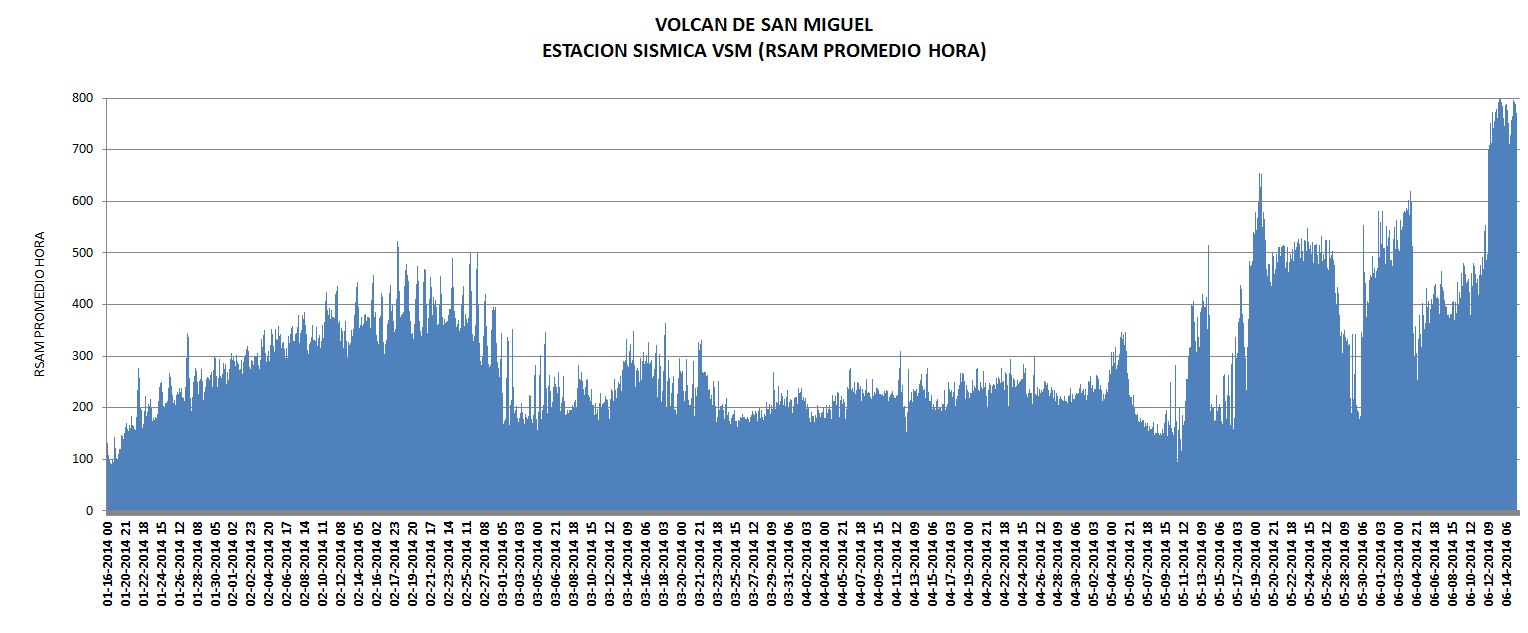
Volcanic tremor under Chaparrastique volcano now reached similar to the pre-eruption of December 2013 measured values. http://www.snet.gob.sv/ver/vulcanologia/informes+especiales/
MARN streams live on youtube.

Screenshot of Chaparrastique livestream on youtube. https://www.youtube.com/user/MARNsv
chryphia


Thank you for the update, Chryphia 🙂
Anyone know how long the lava flow on Etna is?
Etna’s elevation is 3350 meters. Do you think it is halfway down yet?
Don’t know but it looks impressive.
The webcam angle may make the lava flow look longer than it is.
‘Morning all, I haven’t had my first coffee yet but I thought I just grab a few screenshots of Etna before full daylight:


It needs a sniff test, but it might be interesting…
http://www.sciencedirect.com/science/article/pii/S1364682612000417
If valid, it would mean that we are particularly vulnerable to a significant SO2 event pushing harder than it ordinarily would.
Nice one! One should also not forget about the ocean cycles, with especially AMO slowly trending towards the cold phase again. Add the low sun cycle and a tropical VEI-6/7, and perhaps some Icelandic bigger eruptions, and we could be in for a few “fun” years. 😀
Haven’t really had a chance to read it yet, but a cursory look shows that 3 sites were the focus for earth’s temp… that is quite sparce and probably a dubious basis for a correlation. Almost like cherry picking data sets. I tossed it here so that others could validate their conclusions if desired.
A comment read elsewhere that sums it up quite nicely.
“All science is not global – all science is first local and if it is significant enough in quantities it might go global.”
Mornin All,
OT but maybe of interest…
I’ve been offered a months trial in a new job, working in Brighton City libraries, I’m very chuffed indeed 😀 😀 😀
Good luck. Hope you enjoy it. 🙂
Also well done. Do you get access to lots of interesting stuff on volcanoes 😕
Thanks Karenz,
The libraries are involved in the Access to Research scheme:
http://accesstoresearch.pls.org.uk/
Unfortunately only available in the libraries, but I’ve used it to get some papers which seem otherwise paywalled…
Brighton Central library has a pretty good selection of volcanology/ geology books too 🙂
Latest location for EQs, albeit small ones, at El Hierro:
let’s see how this develops…or not….
So far seems to be “not” …….
A short bit of footage of Etna on the BBC:
http://www.bbc.co.uk/news/world-europe-27869840
Catania airport has been closed.
I wish the webcams had sound, too! 🙂
That would be so cool, wouldn’t it?
Some possible activity in far NW Alaska. Area around Noatak has had 4 5.5M earthquakes over the last 6 weeks which is unusual. There have also been some 250 “vigorous” aftershocks. There are three volcanic fields some 90 mi south and east of the area including Maars, basalt flows,small calderas, cinder cones and other features dating 1600 BP to a few million years old. AVO is not yet involved, but it probably is worth watching. Cheers –
http://www.alaskadispatch.com/article/20140615/earthquake-swarm-near-noatak-continues-puzzling-scientists
http://www.avo.alaska.edu/volcanoes/volcinfo.php?volcname=Espenberg
From Link #1
“There are plenty of people wondering if there is going to be a bigger one, because every time it happens, they seem to be getting bigger,”
And the focal mechanism is normal mode faulting… as if two sections of rock are being forced apart… for whatever reason.
Side note… a Mag 5.7 normal mode fault has a down-dip rupture width of 7.16km. At a 24.2 km depth, that would open the fault face to within 20.62 km of the surface.
M5.0 – 250km WSW of Olonkinbyen, Svalbard and Jan Mayen 2014-06-16 14:24:31 UTC
Sometimes, a person with a pet theory will jump on any opportunity to look at data that supports that theory. It’s called selection bias. Seeing the above quake, my mind instantly raced to the quake tracking attempt that I made on the San Andreas. In that, I was able to track what appeared to be minor swarms up and down the San Andreas complex over the extent from the Mendocino triple junction to the Rivera junction.
Though it did not meet my expectations, it is interesting.
This is a plot of the latitude of Iceland’s quakes over the last 48 hours.
Nautilus is approaching a sunken German U-Boat near the Dry Torgusas.
http://www.nautiluslive.org/
It was scuttled 6 years after WWII
This is the one:
http://en.wikipedia.org/wiki/German_submarine_U-2513
And another example of the possibility of the combined effect of multiple stressors causing the elimination of a species. (A collection of coinciding Black Swan events for the affected species.)
http://arstechnica.com/science/2014/06/humans-not-entirely-at-fault-for-passenger-pigeon-extinction/
In the case of the passenger pigeon, the lessening of the effect of a predator and the swelling of a population, then the subsequent oscillation of that population, catching nuisance status in the minds of the replacement population of it’s original predator. This lead to the nuisance group being summarily killed when found.
(bird shit and decimation of fruit trees will piss anybody off. There are still numerous complaints when other migratory bird species camp out in stands of trees around here.)
But it’s nothing compared to the descriptions of the historic passenger pigeon accounts.
And Nishinoshima continues to throw out yet new flavours of interesting…
The Island now has 4 craters and due the high level of activity the authorities have extended the exclusion zone to 6 kilometers and raised the alert level to Alarm.
I find this level of alert to be slightly odd since it is so distant from inhabited land.
I think that they reason like this. The island has suffered from continued inflation as evidenced by the raised shore line of the old part of the island and the continued raising of the rocks out in the water. My estimate is that the island has uplifted by 4 meters or more since january. Also, the Island formation have now halted in the direction away from the old island part as new eruptive material is dumped straight into the abyss at the side of the very large volcano.
One should remember that Nishinoshima is a colossal volcano, far larger than for instance Etna. So, in short, I think the authorities is worried about a part of the underwater edifice will slump down into the through next to the volcano due to inflation bulging and added weight on the flank of the volcano. If that happens think would probably get messy quickly.
In short, I do not like it when a large volcano continues to steadily inflate at the same time as it is suffering from an ongoing eruption. One should note that the current eruption is happening at a side vent of the caldera, so for all we knew the inflation might be higher in the middle of the caldera floor.
The imagery is quite stunning of the 4 craters.
Click to access H260616_nisinosima.pdf
Is it just me who is tired of all the TV channels only showing one thing? And all the screaming fans… And stupid commentators raving about the Korean Seeker dying on the fields after a spell of disgorging (or some such). I am almost about to forgive football.
If anyone wonders what I am ranting about. It is Dream Games from Dreamhack. For those who have missed this, it is 9999 professional video and computer gamers duke it out on their personal super-computers infront of 40 000 spectators during a 72 hour gaming marathon in which the sole winner walks out with a quarter of a million dollars.
A few short nerdy facts, Dreamhack sports the new world record of computer power and the first ever petabit internet. The spent computer power per hour is higher than what the NSA produces in a year and the volume of internal internet communication is higher than Englands yearly computer traffic.
Now I just wonder, what the heck is a Seeker? And yes, it all gets more air-time than the football. No joke.
Old man grumbles away to bed after hearing one of the commentators sprouting this line about a doped up guy with a jolt-gut and pimples “What an athlete!”…
“after a spell of disgorging”
… what? He puked to death?
As for “Seekers,” I have my own definition, and they are not nice entities at all. In my line of experience, they are the autonomous systems that find the target so that the attached missile can kill it.
You want to see real hunter killer robots? Just look for the nearest anti ship missile system. The future is now.
In fact, one design during WW-II had the actual full on intelligence of a pigeon. That’s because they (B. F. Skinner) was teaching pigeons to peck on an image of the target that was displayed in it’s cockpit from the nose mounted camera. The pecking actuated the controlling fins of the weapon and the pigeon would literally drive the weapon to the target. They never fielded that design.
Skinner complained “our problem was no one would take us seriously.”
The thing about water-bound volcanoes, is that once the edifice breaks up enough to allow water in, a caldera eruption is actually highly probable. This is part of why I personally view SakuraJima as being a much more dangerous volcano than many others (even in light of potential VEI-4 or VEI-5 eruptions)
What is the slope angle for Nishinoshima? I believe you mentioned it being rather steep in the past, correct?
I think the more important question is what is the normal repose angle for the ejecta, and if the slope exceeds that… and how does it react to quakes?
St Helens’ landslide was due to a quake. Once the slide lessened the pressure on the cryptodome, it went kablooie.
One should also remember that if a mountain is inflating fast (bulging) the process in and of itself produces cracks in the rock, and if those become large enough even a stable slope will wander of for greener pastures.
That is why I find the angle (around 40 percent) combined with the continuous inflation bothersome.
And since we have been Quayled again: No, it would not cause a huge tsunami, but life for the birds on the islands on the other side of the trench might find interesting times ahead.
How big is the caldera below the ocean?
Dfm showed this JCG bathymetry from prior to the eruption last year. It is not indicated whether the depth is to scale.

I should explain the image.
The caldera is in the downwards corner and the slope inwards is fairly gentle that way. The really steep part is on the other side of the subaerial part of Nishinoshima where it goes rapidly down into the trench (purple).
Nishinoshima and the subaquatic stratovolcano on the right are sitting ontop of the caldera rim.
I think that the scare is that a large part of Nishinoshima would tople over and slide out into the trench causing a significant tsunami. It would also of course create something similar to Krakatau if it happened.
Here´s a link to the Japanese coast guard Nishinoshima page with a depth contour:
http://www1.kaiho.mlit.go.jp/GIJUTSUKOKUSAI/kaiikiDB/kaiyo18-2.htm
You get a better wiev if you look at Google Earth. The caldera stretches from Nishinoshima to Doyo Seamount. Notice how steep the drop is down into the Ogasawara Trough.
Yes, the images are interesting to say the least. Too bad we do not have some link to instrumentation like elsewhere.
Also I understand very well the cautiousness of the japanese. Let’s not forget that there were some deaths of volcanologists and sailors during a similar event. This tragic accident launched the development of umanned robots to get closer to volcanoes.
I’d forgotten that. Didn’t they stray too close and their boat got sunk or something? Tried googling it but couldn’t find it.
Nobody really knows what happened to the boat. It is assumed that they had gone to close to the volcano and a larger than average explosion occured and it was sunk either by falling debris or by the shockwave. Another theory is that a local tsunami wave crushed the ship.
http://en.wikipedia.org/wiki/My%C5%8Djin-sh%C5%8D
myojin-sho, 1952
near Bayonnaise rocks
Thanks!
I wonder how high the water table is. Hawaii for example is soaked to the rim with fresh and salt water, but only seems to have explosive eruptions under certain circumstances. In 1924, this happened after the level of the lava lake in Halema’uma’u Crater dropped below the water table. The walls of the crater then collapsed and blocked the opening down which the lava had drained, allowing steam pressure to build up and cause violent explosions.
http://pubs.usgs.gov/fs/fs132-98/
There is a big big difference between Hawai’i and Nishinoshima. Hawai’i is hotspot driven basaltic eruptions creating soft angled shield volcanoes. So the risk is low for explosive volcanism since the base of the volcano is humongous.
Nishinoshima is a stratovolcano with steep angles and a generally more explosive magma. But that said, Nishinoshima does not seem to follow the subduction meme that well, it seems more to work as a rift volcano.
Judging from the high water vapour content from the vents I would say that the water table is at a minimum of the depth of the ocean level, probably even a bit higher.
The Japan Meteorological Agency has the alert level as orange:
“Near-crater warning; Warning in non-residential areas near the crater; Nishinoshima; 14:00 JST, 11 June 2014” Source: http://www.jma.go.jp/en/volcano/
Although the date is 11/6/2014, I think that the alert level has been orange for longer.
They raised it in their latest bulletin as I mentioned above, and they also extended the exlusion zone for ships to 6NM from 3.5KM.
Is the bulletin available in English? I could not find it on JMA’s site.
Are thrust worried about PCFs? They can travel along way across water.
No way a PCF could flow that far. No, I think they are worried about a mass wasting event as a large part of the volcano slides down into the nearby trench that the volcano is hanging over the edge of.
I think that if that happens they worry about a primary tsunami and a secondary if it all goes Krakatau on us.
The entire island is still swelling up even though there is an eruption going on.
PCFs from Krakatoa went a lot further than 6NM. Not that I am saying that they would do that here.
I would like to point out that Nishinoshima is very far from populated areas. The 6NM (11,1KM) boundary are probably just there to keep stray ships away, this is not one of the more well travelled waters on the globe.
Just as a reference, the VEI-7 eruption of Kikai (likely the largest eruption in the last 10,000 years) had pyroclastic flows that traveled 100km over the ocean. That’s incredibly long, but it still wouldn’t be far enough to reach the remotely populated areas if it were in the place of Nishinoshima.
So in other words, the only particular direct risk to humans from a collapse or huge eruption from Nishinoshima would be a possible tsunami. Indirectly, there could be an environmental impact, although that’s just speculative. Hopefully there would be someone nearby to film such an event while staying out of harm’s way 🙂
Aniakchak did 50 km across land, after that across the same distance over water before whacking out a peninsula on the other side of the bay.
It is probably in the range of Kikai or even bigger.
I do not know, I linked to the japanese one I read above.
I’m wondering at the rate of the eruption, from the lasts views it seems to be picking up ?
According to the researcher activity has increased significantly. There are now 3 active vents and one that is happily steaming, also there are two large lava streams running to either side of the island. Combine that with the continuing inflation and uplift of the island and you have a volcano that seems to be quite some way away from halting the eruption.
By now I think it will continue for the rest of the year, or even longer. Unless of course it autodestructs.
The nearest area where there is any form of population is 130 Kilometers away. You would need an absolutely colossal eruption for the Pyroclastic flows to impact that area (which is a small island that is only barely inhabited).
This one is for Geoloco
Also covered at the Landslides blog which also links to the same video. Cheers –
http://blogs.agu.org/landslideblog/2014/06/17/world-cup-2014-1/
and an update on El Hierro. There was a mini swarm of 5 at the center of island yesterday.
I’ve added a contour top view instead of a grid.
El Hierro Seismic activity update 14 06 17
From 01/06 to 17/06
For the first 2 views, the title bar shows count, datespan, date and hour of the events as well as magnitude.
The color bar shows as usual, date on the left and terrain elevation on the right.
The first view is a fixed view from the south, the second view is a fixed view from the east , both with an event by event animation.
On each view there is a forward tilt of 10°.
The following views are rotations with all events since the beginning of march, and views from the top and back.
Data from IGN and NOAA, made on Gnu Octave 3.2.4 (Linux)
a 5.3 Husafell We shall see if it gets verified
It’s not showing on many stations; and, only clearly on asb.
On the other hand, all the other stations that I am aware of are the other side of the WVZ or MAR.
Of course there may be more stations but is the WVZ or MAR absorbing the shock?
There are several on the same side, Reykjavik is the closest station and it is on the right side.
No, a 5.3 would show all over Iceland.
A 3 should also show on several stations 😕
Yepp, so my guess would be around 2.
I think this might be the culprit behind that massive ghost-quake. And I think even that this one is to large.
Tuesday 17.06.2014 19:59:02 65.060 -20.619 0.4 km 2.2 38.75 33.7 km NNW of Eiríksjökull
I get it as a M3.2 or lower that happened pretty much straight under ASB.
This is not an M5.3
19.58.39.5 M3.2 14.7KM SE HUSAFELLI
One can clearly see that the alleged 3.2 corresponds to the initial break on the SIL.
My guess? Shallow M2 or even less.
The big problem is really that the entire region out to Snefellsjökull is not covered, so ASB is the easternmost SIL, so anything recorded there will be very hard for the automatic system to interpret. In this case it took the third signal and added up the given station strength, it could not assign depth, and therefore assumed that it was a honking big one.
System bug more or less.
That region needs more equipment, after all there is an active volcano there to the west.
Seems to be in a small valley near Snjofjoll and another heavily eroded volcano (can’s see its name on the maps) east of SVB. Trying to find out how old the volcanics are there. Perhaps Icelanders have more information.
I would not put a lot of energy into it, this is not a real earthquake. Unless you wish to learn more about one of the few unvolcanic parts of Iceland of course.
The EQ might not be real but the volcanics are: tertiary and some later quaternary 😉
For Iceland that would be as unvolcanic as is possible
I’ll be interested if there really was a quake here, as last week we visited all around the region (Thingvellir National Park, Vik and Barnafoss, etc) and didn’t feel a shiver or a quiver! 😉 Iceland – what a wonderful country! We have returned home with our heads full of unbelievable sights, hundreds of photos and hoping to see more one day.
Three very small eqs on Katla: http://en.vedur.is/earthquakes-and-volcanism/earthquakes/myrdalsjokull/#view=map
Suspect it is just a twitch in the ice- cap.
Sorry, I had a twitch too when keying this in so there is a duplicate.
Dragons, feel free to delete the duplicate. Thank you 🙂
DragonEdit: Duplicate has been fried on the BBQ and eaten with a fresh salsa
Tenerife has had a few small earthquakes this morning: http://www.ign.es/ign/layoutIn/volcaListadoTerremotos.do?zona=2&cantidad_dias=10
And for those who dream dark dreams of Katla erupting. The first mediumsized earthquake has struck Katla today. Medium-size for Icelandic volcanoes are between M3 and M4.4.
The earthquake had no magmatic component and the depth seems to say that it is more related to fracturing of the top of the chamber as the magma shrinks due to cooling.
There are also almost no aftershocks, so most likely no eruption coming.
Wednesday 18.06.2014 10:20:53 63.653 -19.163 1.8 km 3.1 99.0 4.5 km ENE of Goðabunga
So, no hat eating for now. 😉
OT, but interesting: huge ice formations under Greenland’s icecap. Apparently, ice can be as dynamic as magma under high pressure.
http://www.livescience.com/46342-ice-sculptures-discovered-under-greenland-ice.html
Sorry if already posted.
I thought you would be glued to a seat watching football 🙂
In honour of you I have decided to be a honorary Brazilian for the next few weeks. Opera maniacs need to stick together 🙂
The second part about how earthquakes travel as sound waves is now posted!
https://volcanocafe.wordpress.com/2014/06/18/leave-your-sineful-ways-behind/