Sorry, chocoholics this is not about chocolate or cake 😦 (although, as this is Volcanocafe, it could be!). No, we are looking at arc-to-continent collision round the Banda Sea 🙂
I continued my plotting of Indonesian earthquakes eastward, this time choosing the Banda Sea where the “swirly bit” on the map looks interesting; and, is it interesting!
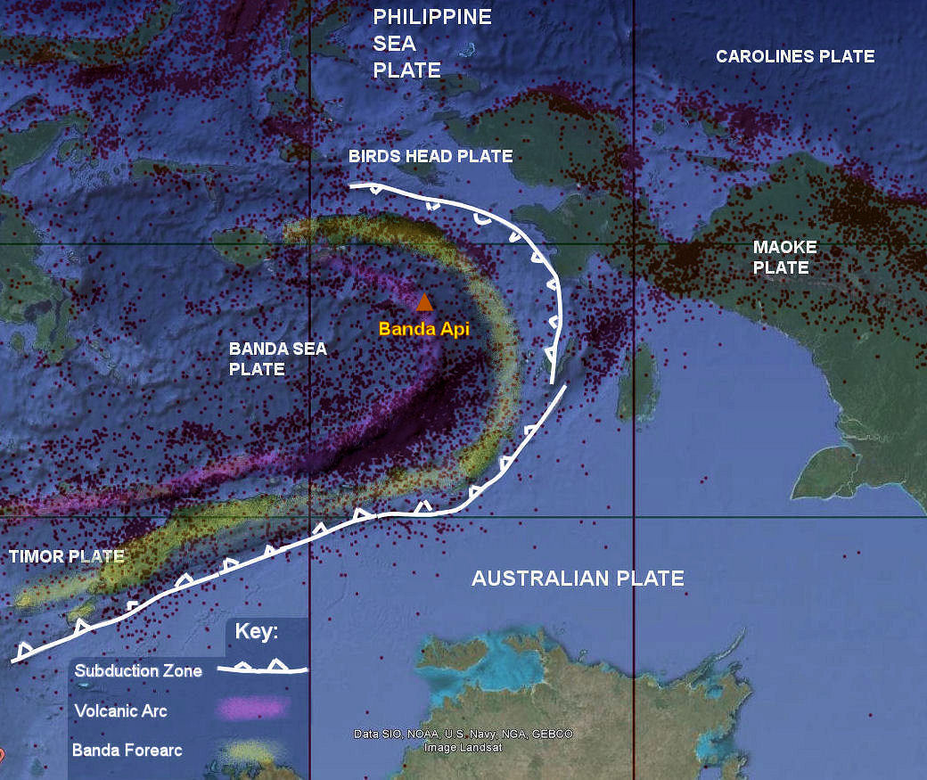
Fig 1: Latitude v Longitude plot of earthquakes by the author, superimposed over a map of the area from Google Earth. Copyright for the earthquake plot rests with the author; reproduced here with kind permission.
Here we can see the Banda Arc in eastern Indonesia, a double island arc formed from the collision of the Indo-Australian Plate and the Eurasian Plate. The outer arc is tectonic (the Banda Forearc above); and, the inner arc, volcanic [1].
We’ll look first at each arcs; then take a look at one volcano, Banda Api.
The Outer Banda Arc and the Banda Sea
The outer arc overlies the margin of Australian Pre-Cambrian craton [1]. The arc is made up of the following belts, working from the inside of the arc to the outside: an ophiolite belt; a metamorphic belt; a thrust and fold belt with Permo-Triassic and Jurassic sediments from the Australian continental margin; a thrust and fold belt with Late Mesozoic and Tertiary deep water sediments; and, a belt of uplifted Late Neogene basins. The older rocks occur on the inside of the outer arc and the younger rocks occur on the outer side. According to the geologists, this is contrary to plate tectonics theory, which would predict an accretionary wedge, composed of younger oceanic sediments, on the inner side of the arc [2].

Fig 2: Banda Arc Cross Section by Herman Darman, published under Creative Commons Attribution-Share Alike 3.0 Unported license. Colours denote: red, volcanic arc; green, metamorphosed basement with ophiolite fragments; yellow, thrust and fold belt with Permo-Triassic and Jurassic rock; and blue, thrust and fold belt with Tertiary rock. Source: http://commons.wikimedia.org/wiki/File:Banda-arc-cross-section.jpg
De Smet (1999) attributed the continental basement rocks and Early Mesozoic continental sediments found on the inner side of the arc to inversion during the plate collision between Australia and the Banda Subduction Zone. The collision compressed the northern rim of the Australian continent, pushing up continental margin sediments on the back of continental basement to form the islands of the Outer Banda Arc [2].
The Banda Sea’s origins are also complex. It may have been formed by either back arc spreading or trapped oceanic lithosphere from the Indian Ocean. Bird (2003) suggests the presence of a microplate, the Banda Sea Plate [3].
So what do the earthquakes tell us?
Earthquake Activity
The area is tectonically very active and home to some large quakes, for example the 8.4 Mw in 1938, The Banda Sea Quake [4], and a 7.5 Mw in 2006 [5].
Plotting earthquakes from 1994 to June 2014 (earthquake data downloaded from USGS: http://earthquake.usgs.gov/earthquakes/), we see very clear evidence of subduction, most strongly between the south eastern forearc basin descending beneath volcanic arc:

Fig 3: Longitude v Depth (looking north) by the author. Copyright rests with the author; reproduced here with kind permission. The lines for longitude are the same as those in Fig 1.

Fig 4: Latitude v Depth (looking west) by the author. Copyright rests with the author; reproduced here with kind permission. The lines for latitude are the same as those in Fig 1.
A rotating plot of the earthquakes shown above can be viewed here:
We can see the subduction of the Australian Plate in the south and what appears to be a second subduction zone in the north. The latter may be either a continuation of the subduction of the Australian Plate (the subduction zone having bent round); and / or, it may be subduction of the Bird’s Head Plate under the Banda Sea Plate. However, the margin between the Banda Sea Plate and the Bird’s Head Plate is described in Wiki as a convergent margin [6].
The Australian Plate is made up of continental crust. Continental crust is more buoyant than oceanic crust so it is perhaps surprising to see seismicity reaching a depth of 675 km. If the continental crust has subducted, we may find evidence in the lavas of the volcanic arc. Let’s now look at the volcanic arc.
The Volcanic Arc
The volcanic arc is the inner arc, made up of active volcanic islands. All volcanoes in the arc are stratovolcanoes, and the Banda Archipelago and Nila also have calderas [7].
Jezek, P.A et al (1978) noted that lavas are consistent with those of other island arcs, ranging from tholeiitic basalt and dacite on S. W. Ambon and Banda, through low-K calc-alkaline andesites on Manuk and Serua, to high-K calc-alkaline andesites on Nila, Teun, Damar, Gunungapi Wetar, and Romang (which also contains dacite). Older cordierite dacites (ambonites) on North Ambon must be derived from underlying continental crust, but the younger tholeiitic lavas of S.W. Ambon and Banda may be related to a shallow subduction zone dipping southwards from Seram. [8]
Vroon, P.Z. et al (2001) looked at the oxygen isotope (δ18O) of the lavas in the Banda Arc. They found that the lavas from the Banda Archipelago, Manuk, Nila, Damar, and Romang include subducted continental material. The percentage of bulk subducted continental material tends to increase along the arc from less than 1% in the Banda Archipelago to more than 3% in Romang. This appears to reflect an increase in subducted continental material towards the arc sector near Timor, where the Australian continent collided first [7].
And now let us look at a volcano. I picked Banda Api because she is close to the subduction zone at the north east end of the Banda Sea Plate and she appeared on the map to be associated with a caldera.
Banda Api
Banda Api is a volcanic island in the Banda Archipelago. The archipelago is made up of ten volcanic islands. The main islands are: Banda Neira, or Naira; Banda Api, an active volcano; and, Banda Besar. Banda Neira was once the global center of the trade in nutmeg and mace [9].

Fig 5; Map of the Banda Islands by Lencer, published under the Creative Commons Attribution-Share Alike 3.0 Unported license. Source: http://upload.wikimedia.org/wikipedia/commons/5/5c/Banda_Islands_en.png
According to GVP, Banda Api, herself, is a basaltic-to-rhyodacitic volcanic island, located in the SW corner of a 7 km wide caldera. Her setting is described as subduction zone, oceanic crust (<15 km). Her major rock types are listed as dacite; andesite / basaltic andesite; and, basalt / picro-basalt [10].
There have been two or more episodes of caldera formation. Bandar Besar and Banda Neiro are possibly remnants of pre-caldera volcanoes. Gunung Api is the 640 m high conical peak in the center of Banda Api island. 27 eruptions have been recorded since 1586, mostly strombolian activity from the summit crater and occasional lava flows. Of the 27 eruptions, 13 were VEI 2; and, 8 were VEI 3 [10]. The last large eruption occurred in 1988, leading to the evacuation of 10,000 people [10].

Fig 6: The 1988 eruption of Banda Api. Photo by Willem Rohi, 1988 (Volcanological Survey of Indonesia). Source: http://www.volcano.si.edu/Photos/full/008036.jpg
Hope you enjoyed this whistle-stop tour of the Banda Arc. The usual caveats apply: “not an expert, etc… “
KarenZ, 28 June 2014
References:
- “Banda Arc”, Wikipedia: http://en.wikipedia.org/wiki/Banda_Arc
- “The Geology of Indonesia/Banda Arc”, http://en.wikibooks.org/wiki/The_Geology_of_Indonesia/Banda_Arc
- Bird, P. (2003) An updated digital model of plate boundaries, Geochemistry Geophysics Geosystems, 4(3), 1027, doi:10.1029/2001GC000252 http://peterbird.name/publications/2003_PB2002/2003_PB2002.htm
- 1938 Banda Sea Earthquake, Wiki: http://en.wikipedia.org/wiki/1938_Banda_Sea_earthquake
- 2006 Banda Sea Earthquake, Wiki: http://en.wikipedia.org/wiki/2006_Banda_Sea_earthquake
- Bird’s Head Plate, Wiki: http://en.wikipedia.org/wiki/Bird%27s_Head_Plate
- Vroon, P.Z., Lowry, D., van Bergen, M.J., Boyce, A.J., Mattey, D.P. “Oxygen Isotope Systematics of the Banda Arc: Low δ18O Despite Involvement of Continental Material In Magma Genesis”, Geochemica et Cosmochimica, Vol 65, No 4, pp. 589 -601, 2001.
- Jezek, P.A., Hutchison, C.S. “Banda arc of Eastern Indonesia: Petrology and geochemistry of the volcanic rocks”, Bulletin Volcanologique, 1978, Volume 41, Issue 4, pp 586-608 http://link.springer.com/article/10.1007/BF02597389
- Banda Islands, Wikipedia: http://en.wikipedia.org/wiki/Banda_Islands
- Banda Api, GVP: http://www.volcano.si.edu/volcano.cfm?vn=265090
A new season of Friday riddles starts today, this week under the aspect of the soccer world cup!
1) In 1791, hope came to the land of men, but then France took it away. Answer: The Marquesas hotspot. The Marquesas are known as the “Land of Men” in the native language. An American fur trader arrived on the ship “Hope” in 1791 and claimed it for the USA, but France later took over the islands. Sissel, 2 points.
2) Another one of Darwin’s stops. Can you hear the drums? Clue: Base of operations for rescue and recovery for a famous plane crash. Answer: Fernando de Noronha. Darwin briefly stopped here. “Can you hear the drums, Fernando?” is a line from “Fernando,” one of ABBA’s hits. RenatoRio, 1 point.
3) The island is named after it’s inspiring castaway, who helped save his rescuers recover. Answer: Alejandro Selkirk Island. Alexander Selkirk inspired the book Robinson Crusoe. His rescuers were in bad shape from scurvy, and he helped them get enough vitamin C to recover. Sissel, 2 points.
4) The treasure of the Maya bursts forth; it can be found on many plates. Partial answer: It has to do with Chocolate…. 🙂 , KarenZ, 1 point. Bonus points may be awarded for Cacao volcano, Cerro Chocolate and Chocolate fountain 🙂 . Answer: Molten Chocolate lava cake, although KarenZ stated in the beginning that this post was not about chocolate or cake 😉 .
MATT


3 Could be Robinson Crusoe Island.
Almost 🙂
3 Then Alejandro Selkirk Island.
DING!
4 Looks like it should be gold 🙂
Nice try 🙂
And 2 could be Osorno Volcano, Chile (Darwin saw it erupt in 1835, staying on Chiloé Island).
Nope
2 Then Galapagos Islands, Umbrina galapagorum (a fish) being the drum (“Galápagos drum”).
Galápagos Islands it was meant to be.
More specific it could be San Cristóbal Island, the first island of the archipelago Darwin visited with the Beagle.
No 🙂
3 Monuriki
Or Kennedy Island, formerly Plum Pudding Island, renamed after John F Kennedy and party washed ashore there.
Sorry, no 3 was solved by Sissel, Alejandro Selkirk Island.
Number four – can it be obsidan?
Not in this case 🙂
Slight editing of the post on my road from Portrait of a Musician to wine and cheese on the balconetta…
Sorry all for the absence, hectic week at work, and a lot of other fun stuff 🙂
Ciao!
🙂 and 😦 seem to have been swapped round 😕
Fixed it :-).
🙂
And to continue the discussion over from the other page on fracking and seismicity.
My experience after having bossed over drilling into unsavoury places…
First of all, we drilled for hydrothermal energy, and not for the purpose of gas or oil extraction. But, it is still basically the same.
The difference is that we did it into an active volcano, so we littered the place with equipment to monitor the volcano. This gave us an edge that I think gives me the experience to pull the argument.
Does fracking cause earthquakes? Without a shadow of a doubt.
Does fracking always cause earthquakes? No, it does not.
What then makes some places seismic and others not? Well, first of all you need a fracture zone, ie an active fault. If you have that you get seismicity release from the fracking, and in case of gas-fracking you will probably get gas release.
What prevents seismicity? The lack of faults… Most fracking holes are not near a fault, so most holes will be aseismic.
In the end you probably should not frack a hole that is near a faultline for several reasons.
So, how come I am so cathegorical? Well, 100 percent of the holes we drilled near faultlines quivered like jello on a rollercoaster. 95 percent of the holes that was not near a faultline was aseismic. The only hole that broke the rule was one that was way closer to a pocket of magma than we expected, it turned into a runaway train both seismically and steamwise… And remember, we learned where all the faultlines was over the time the project ran.
So, were are we now? Well it seems that both the frack-friends and frack-enemies are equally right at the same time. And also that both referenced papers in the previous thread are correct.
And if you decide to repair a pinhole in a gasoline tank by braising…. it might blow up in your face.
A story told to me by my dad about a guy he knew who tried to take precautions for such a task.
The person took a really heavily built iron/steel table and welded a section of heavy plate steel to one end, vertically, that he could stand behind. He had placed a really small hole in it to look through, and had made cut-outs so that he could easily reach around to work on the tank from behind the plate steel shield.
Feeling adaquately prepared, he placed the ailing fuel tank on the bench and began to work. A short while later, there was an explosion. Looking around, no one could see the guy. They found him laying nearby, with his large plate steel “shield” pinning him to the ground. He survived, but was pretty banged up from the ordeal.
Moral of story? Just because you think that you have taken appropriate precautions… you may be very very wrong in your assumptions.
Note: This is not a “Florida Idiot” story. At the time, my dad was a bus driver in Marin county California. He never told me exactly where it happened, but it was probably in the maintenance depot for the bus company.
It was kind of why we cancelled the project… We took all precautions, and we still were near to bungling things, and also our precautions showed us (due to the seismicity) how impossible it would be to avoid magma pockets…
We also noticed that the honking big volcano was just the side vent of a much much larger system. It was fast time to leave Dodge. Outside the caldera there was no energy, and inside we have a warrens nest of magma pockets covering a 120 kilometer wide caldera floor.
Where was that at?
Fako.
Looks like at one time one of the vents had a run that made it all the way to the Atlantic sometime in the past. (Gurgle Earth imagery)
The last eruption almost made it to the coast… If memory serves it stopped 300 meters from the shore.
This volcano erupts about every ten to fifteen years. The last activity was small phreatic detonations in 2012, and the last real eruption was in 2000.
It is the modern vent of one of the oldest volcanoes on earth. Todays volcano sits on top of a modern hotspot, but it is also sitting on the side of a ginormous caldera that may have been the original spot of the break up of South America and Africa.
The old supervolcano is not active any longer for the same reason as it originaly was, but it contains amazing amounts of pockets of lava and might actualy be reactivating due to the hotspot. And mount Fako is a true beauty for so very many reasons.
Here is the piece I wrote about Mount Fako (Cameroon) in 2012. It is based upon the work we did.
https://volcanocafe.wordpress.com/2012/02/07/mount-cameroon-on-the-brink-of-eruption/
4) Tabasco sauce
Good idea! 🙂
4) Popocatepetl (bit of a word play 😉 )
or 4) andesite (not sure how that is treasure but it fits the rest of the clue …. )
or 4) jade / jadeite, which the Mayans used: http://en.wikipedia.org/wiki/Jade_use_in_Mesoamerica
I assume you will love the answer 😉
Chocolate 🙂
Yay! That earns you 1 point, now give it a volcanic touch 🙂
Chocolate fountain? Lava fountain 😕
Or Cerro Chocolate a.k.a Cerro Colorado 🙂
Chocolate fountain, Cerro Chocolate and Sissel´s Cacao volcano are all wonderful answers, but not what Matt has in mind. I would give out bonus points, but I´ll leave the decision to him 🙂
4 It almost HAS to be Cacao Volcano within Guanacaste National Park, Costa Rica!
1) Graham Island or Ferdinandea
KarenZ : Good work. First class. On fast track making usual caveat obsolete 😉 🙂
“”” The usual caveats apply: “not an expert, etc… “ “””
Have nice weekend all.
Thank you 🙂
Like a bat out of hell…
Note: The natural tendency is to rush out and merge with the Semi-Permanent Icelandic Low.
4 – Cocos Ridge
Morning all. #4, Epidote or Pegmatites, often described as avocado green in colour.
2 Ascension Island
The weather has been quite stormy, windy, heavy rains and now chilly in Iceland, for the past few days.
Some floods and mud flows in the north of Iceland. Today, there is a north gale everywhere in the country, and the temperatures are chilly. Here in the south it’s 7ºC, in the north many coastal places have 5ºC or even 3ºC. Heavy rain in the north, just some rain in the south.
It will certainly snow in many highland spots. A little bit of wintertime in the middle of the summer!
If Hekla would erupt now (it’s certainly restless in last few days), its ash would be carried right into Europe (Ireland, Uk, France), due to the current northern gale. Winds have been up to 130km/h gusts.
And hurricana Artur will likely hit south Greenland on Monday, and possibly Iceland in Wednesday. Quite a rough July weather-wise in Iceland!
Jolly glad I was there at the beginning of June … wonderful weather with people actually sun-bathing in Reykjavik!
Consider you be very lucky! This has not been possible for many weeks now. Actually have forgotten that such weather can exist 😉
1 The Marquesas Islands? “(French: Îles Marquises or Archipel des Marquises or Marquises; Marquesan: Te Henua (K)enana (North Marquesan) and Te Fenua `Enata (South Marquesan), both meaning “The Land of Men”) are a group of volcanic islands in French Polynesia, an overseas collectivity of France in the southern Pacific Ocean.” From: wikipedia.
More: “The American Maritime Fur Trader Joseph Ingraham first visited the northern Marquesas while commanding the brig Hope in 1791, giving them the name Washington Islands. In 1813, Commodore David Porter claimed Nuku Hiva for the United States, but the United States Congress never ratified that claim. In 1842, France—following a successful military operation on behalf of a native chief (named Iotete) who claimed he was king of the whole island of Tahuata—took possession of the whole group and established a settlement (abandoned in 1859) on Nuku Hiva. France reestablished control over the group in 1870, and later incorporated it into French Polynesia.” – Also wikipedia.
DING! You nailed it! 🙂
Number 2: Terra del Fuego, Patagonia?
Great post, KarenZ, animation and all. This is the kind of theme I like the most. Congrats!
Thank you 🙂
Interesting location for an EQ:
Mw 6.0, NORTHERN SUMATRA, INDONESIA, 2014-07-05 09:39:31.7 UTC, 2.06 N ; 97.08 E, 40 km
http://www.emsc-csem.org/Earthquake/earthquake.php?id=389260
That is the very tsunami prone area, where there have been several catastrophic ones as long as I am watching. 😦
Thank you KarenZ, one of the posts I will come back to to read up several times!
Btw, the Kelud crater cam has returned to its pre-eruption position 🙂


Here is a screenshot. As it was a very steamy affair, I have added a photoshopped b/w version were more detail of the crater can be seen.
Link to the webcam: http://www.vsi.esdm.go.id/index.php/gunungapi/kamera-gunungapi
Individual cam link: http://www.vsi.esdm.go.id/cam_detail.php?id=14
The highlands near Askja today. A fresh 40cm thick snowcover!

Quite a winter day today in Iceland. The strong wind continues here and temperature around 9ºC, now sigjificantly warmer than in the morning, due to sun beginning to shine, despite the cold north wind.
Snow is falling and accumulating at least at 800m high.
quite a lot on the news. roads cut, cars with trailer that went on sideways while driving, toilets that flew away in a camping festival in the north of iceland, etc…
“toilets that flew away in a camping festival”
… so you’re saying the population of Blue Smurfs has gone up in Iceland?
Yep, portable toilets, doors flew right off – I heard this too on news, never go to such events in bad weather, always check forecast first 🙂
And Yep, almost winter again – in July!
I was mainly referring to the skin staining from the blue water… a most disgusting affair.
brrrr!
A clue to No 2 is now appended.
I’m still stuck at number 2.
The Beagle stopped at St. Peter and San Paul’s rocks, where there were teams rescuing an Air France airplane crash; then Fernando de Noronha (the same) – but I can’t hear any drums (???).
Drums could be possibly heard in Darwin’s next stops, Bahia or Rio de Janeiro, perhaps, but I don’t see any relation to volcanoes. Then Tierra del Fuego, but that was my first hint. 🙂
DING!
I don’t deserve! Hahaha! My first ever Ding! With ABBA!
Hi all I am had a nasty time trying to get my flight physical paperwork done . One of the reasons I haven’t been active is that and some other computer related issues. My computer Guru split for an extended Yellowstone trip so my computer sits in the shop
whist he and wife spend time in Yellowstone (Ironic to a degree.) Finally go it done so I
can fly with my new hip-seems this one is not yet approved so I had to get a field approval. Not really huge problem but I was about to go to Seattle of Oklahoma City .
Survived the Fourth of July with my Redneck Neighbor: No fireworks!! Kid didn’t sit a
propane bottle on the grill (21 year old kid) and he didn’t light off the remaining Arbor Vitae
with his huge torch.
Interesting post!
One other thing. Here is an article of a proposed LPG port in Coos Bay, Oregon.
http://www.oregonlive.com/business/index.ssf/2014/06/coos_bay_lng_terminal_designed.html
My take:
1, it is being designed with the idea of a 9 mag quake and Tsunami .
-if that happens it will be the least of their worries in Coos Bay Most of the place is not
even prepared for something like that.
2. It will bring jobs to an area that is devastated by poverty, drugs and hopelessness .
-therefore it is a bad Idea.
3. in the article the “IT IS OVERDUUUUE!!!!) card is being played. In regard to the
quake possibility. My BS meter is now off the scale..
4 Hmmm… chocolate bar.. chocolate slab.. tectonic plates are giant rock slabs!
Subducting slabs being the most volcanic slabs.
#4 Chichinautzin Volcano? Or rather its lava tube system wich includes a “Chocolate Factory”?
“…you see Chichinautzin Volcano, which is the source of many of the lava tubes in this area. (…)
By far the most impressive part of the cave (for me) was the Chocolate Factory. The ceiling drips with shiny, chocolate-colored stalactites and draperies. Chocolate “dribbles” run down the side walls….”
from: http://www.saudicaves.com/mx/pelig/
Not for global warming aficionados: http://www.dailymail.co.uk/news/article-2681829/Global-warming-latest-Amount-Antarctic-sea-ice-hits-new-record-high.html
And if you think that this article is a bit confusing… It could be worse. It could be the train wreck of the formation of the Gulf of Mexico and Caribbean.
Click to access Pindell01_Caribbean_GCSSEPM.pdf
Think I need to print that paper out to follow it – it covers a long time span. 🙂
Not an expert, but suspect that there may have been another plate(s) between the Australian Plate and the Banda Sea Plate – the source of that deeply subducting lithospheric slab.
New activity on Etna? http://oi59.tinypic.com/34y47du.jpg
Source: http://www.ct.ingv.it/en/webcam-etna-en.html
New video of an expedition to Batu Tara by Geoff Mackley:
And as for the remaining riddle no 4, don´t believe what KarenZ wrote first 😉
Gold?
Still not gold, just a happy coincidence 🙂
Enough teasing I think and bedtime here. The answer was Molten chocolate lava cake 😉

Coincidentally you wrote in the beginning of your post “Sorry, chocoholics this is not about chocolate or cake 😦 (although, as this is Volcanocafe, it could be!)”, and so it was 🙂
Grrr …. I checked out lots of varieties of chocolate cake but thought they were nit volcanic enough!
* not.
I know and fully realize what Carl said about Katla a few times some time ago. So keeping that in mind, can someone explain nonetheless, what is causing these quakes at Katla at the moment. Some are very shallow, probably in the ice, so that would make sense since its summer and that has an effect on the ice. But what about the rest, and the deeper ones that were really the first to appear a month ago in the same part of the caldera? It cant really be all pure tectonics only… Or can it? 😀
I looked again at the earthquakes for the last few weeks, and the quakes are manly tectonic, small, and still below average numbers for Katla. I reiterate, what we see now is still below the levels of seismicity that is normal for this particular volcano.
So, nothing really to write home about. And the signature is tectonic, not magmatic.
How much below normal? Well, the energy release is about one tenth of normal levels, and Katla has had highs that are 100 times above normal without erupting. So, this is about 1000th of what a large non-eruptive earthquake swarm can look like.
So, if you see an increase in the order of 1000 to 10 000 times more energy release, then it is time to start smiling…
Possible causes (from what I know):
Magma cooling in the chamber: Like most materials, magma expands and contracts depending on heat. As it cools down, it will contract, which eventually leads to small earthquakes. Torfajokull has been having contraction earthquakes for a very very long time from what I know.
Tectonic movement: As you mentioned, some of these may just be tectonic movement around faults. Sometimes, tectonic activity *can* be caused by volcanic activity, but that’s less common.
Magma injection: It’s possible that very small injections can cause small earthquakes. Keep in mind, most volcanoes will see a lot of magmatic injections before an eruption. This doesn’t mean a volcano will erupt.
Magma movement: Magma can slosh around without a fresh injection, and will often move from place to place in a magma chamber. This is often a product of the cooling or heating process, but also can be related to the fractionation process. Once again, this isn’t typically related to an imminent eruption.
Hydrothermal activity: As you mentioned glaciers being a cause of earthquakes, water in the ground can also do the same, especially when it comes into contact with hot rock or magma, subsequently flashing to steam.
Also, keep in mind, most of the quakes we’ve seen at Katla have been extremely small. Earthquakes that are less than 1.0 on the richter scale are extremely weak, and even up to 2.0, they really don’t mean all that much outside business as usual. So, they may not all be purely tectonic, but for a lot of these, you can look at the seismogram or drum plots, and tell that the earthquakes ARE tectonic in nature since they have no tremor component which would be indicative of magmatic injection.
Think also that the caldera wall is not that stable so some small quakes come from movements there, especially when ice melts.
And next to Katla something more interesting is popping and bopping a bit. This earthquake was earlier today, and we had another small one later.

Notice the lack of a clean break at the beginning of the quake, first there is tremor, then it snaps as the magma pushes. The 16.50ish part is most likely volcanic fluids moving, and there is no hydrothermal activity there so most likely prowling magma.
And the 16.36 quake with the following sloshing is now showing on the hekla plot.
Even though there is a cold spell and snow has fallen in Iceland the top of Hekla is now completely snow free along the top fissure.
http://hraun.vedur.is/ja/hekla/cam/burfell-cam.html
That uh, sort of says something…
I find it interesting, but I do not know if it means something.
Like?
@Tyler.
Water is one of the most beneficial liquids on this planet. One of it’s really useful features is it’s really high heat capacity. It takes 4181.3 Joules to raise the temperature of one kg of water by 1°C. (or one Kelvin). Sure, the snow and ice could have sublimated away, or it could have melted and ran off (most likely) but the fact that the summit is clear points to a significant amount of energy coming up through the terrain.
The other likelihood is that the wind blew the summit clear of snow. But something of that nature would have been noticed by the meteorological guys because that would have been one nasty arsed wind storm.
And it is also a bit weird that it has happened at the same time as iceland has very cold weather and lots of snow has fallen.
Hekla summit was at least this snow-free, in extent, when I went to its top, back in August 2011.
I think its pretty normal, the ground temperature at Hekla summit is around 50ºC
However people have pointed out to this absense of snow in the past decades, as a sign prior to eruptions. One thing is sure, in the last week there has been I think 3 quakes in Hekla. Its resembling what happened back in March 2013, when Hekla was near an eruption, while having one or two quakes every 3 days.
Thanks Carl for making us aware of and explaining those different types of small signals. This helps me a lot in learning to read other seismograms on my own. The difficult part is to know the properties of the area in question, like e.g. “there is no hydrothermal activity there, so…” How would you know with a faraway volcano whether or not there is hydrothermal activity? Thats where I give up, because I never know what circumstances to take into account.
Btw., I would like to ask you and other commenters on Icelandic issues, please do say *where* you are talking about. I’m sure everyone of you specialists know where VI IFED is but I (and I guess others too) have to do some rummaging to find Chryphia’s map and look up the location first before we can start understanding the text. Thank you! 🙂
Ahem, mea culpa 🙂
It is Hekla we are talking about. Sorry that I forgot to say that.
Here is one for KarenZ: you were right the other day assuming a new vent on Etna:

…and (if it’s not the rising moon 😀 )

OT.
A large fire has started in Reykjavík tonight.
No news of any injuries or deaths.
Links in Icelandic.
http://www.mbl.is/
http://www.ruv.is/
Quite a big fire. Apparently it is possible to see it from Kekflavik.
http://www.ruv.is/frett/sprengingar-heyrast-i-skeifunni
From Jon: Two highly tornillo earthquakes (magma earthquakes) took place in Katla volcano just now. Automatic magnitudes are 1,6 and 2,8.
Quite a wee swarm… http://www.vedur.is/skjalftar-og-eldgos/jardskjalftar/myrdalsjokull/
Hello all and a Beautyful Monday to you!


Here’s one animated hour Stromboli (09.39-10.39 UTC) from the thermal cam SQT
source: INGV http://www.ct.ingv.it/en/webcam-aeolian-islands.html
Cool animation 🙂
Interesting to note that if you start watching it a few moments into the sequence, it looks like the lava is going up hill, not down.
M 7.0 – CHIAPAS, MEXICO – 2014-07-07 11:23:59 UTC
http://www.emsc-csem.org/Earthquake/earthquake.php?id=389631#map
Two dead in Guatemala from it.
If it’s just the two, then they beat the statistical model. USGS places it as a Mag 6.9 with a 34% chance of between 10 to 100 fatalities.
Well, the unfortunate two that died didn’t beat it, but the population group as a whole.
Sadly, it is three deaths in Guatemala and one in Mexico.
Source: http://earthquake-report.com/2014/07/07/massive-earthquake-mazatan-mexico-on-july-7-2014/
No aftershock so far, weird.
according to Armand at Earthquate report Update 17:37 UTC : Mexican SSN reports many aftershocks, the strongest one measuring 4.5 (below damage level for not yet damaged buildings)
Thanks! Just checked SSN http://www.ssn.unam.mx/ultimos.html , but no more earthquakes on that list.

Seismogram from http://www2.ssn.unam.mx:8080/website/jsp/mxig-gif.jsp
interesting – I wonder if Armand has some direct contacts with folk there 🙂
Hi Chryphia! I was wondering the same myself, but Edward below corrected our thoughts. Then I noticed that the beach balls were showing a divergent pattern instead of a collision-type, thrust, EQ which I would have expected from that very plate boundary. Nevertheless, USGS has the explanation: “The mechanism of the earthquake is consistent with extension within the down-going Cocos slab. The earthquake occurred below and to the east of the slab interface where larger, thrust-type earthquakes can occur.” Why extensional earthquakes show no or merely a scant sequence of aftershocks (at least in my lay, tired, memory) is anybody’s guess. As for my guess, this one could have been worse and caused more extensive damage had it been a true thrust quake. 😉
I always figured extensional released tension – a bit like ripping a tough plastic bag, one big rip and then maybe a couple of small tears at the edge, with air filling in the gap – presumably magma does that job underground, but then nothing stopped the pull (except coming to the end of how far you wanted to pull – so once the extensional tension was enough to start the rip is pretty much all went in one pull, until something starts ratcheting the tension up again)
but with compressional I always presumed that it stopped pushing past/over/under the other plate due to friction (rather than having released all the pressure in that one go), with lumps and bumps ‘snapping off’ or pushed flat/bounced past as each of the aftershocks.
That could probably do with someone who actually know what their talking about to look at – but that’s been my mental image of it – dunno if it is right or not though.
Well, since you brought it up. There is always the odd possibility of of getting your slab cut off by another descending plate. On possible example is the Farallon getting sliced by the subducting sea crust from a colliding Yucatan down in Mexico. The other possible scenario is slab tearing
http://www.gps.caltech.edu/~clay/MexWeb/MexSubduction.html
… and guess what volcano is sitting directly over top of the show…
Wow, Etna’s new cone is getting angry 😀 Strong strombolic activity
Livestream: https://www.youtube.com/watch?v=4VOPk3_QEiU
Would this be a Tornillo, or just an average tectonic quake?
Subject: Iceland – Hekla / Katla.
Quake 22.08.11 was (I think) on Heklas eastern ends, it did not register at HAU (because that has broken capacitior my source says)
Nut see here for yiourself , tornillos are quite different in “shape” (waveform?) that Katlas quakes last night. So Jón is wrong on this beeing “magmatic”.
But I forgot save them and all dissapeared at midnight.
(I guess that is what Cindereallas do?)
The big one? Looks mostly sharp tectonic but has a little ‘tail’. The small one around 08.30 looks more interesting…
General link
http://en.wikipedia.org/wiki/Volcanic_tremor
Spent the day driving to Parker FL. Got there and opened up the box for the new monitor and noted a label on it that said “Bad – Replace.” Instantly I knew that this wasn’t going to turn out well. Sure enough, the “new” monitor was in fact bad, so I have to make that trip again in two days. Two days because I’m gonna be tangled up with another call tomorrow. My initial reason for sloughing it off was that I didn’t know where my laptop was at, and didn’t have time to go tearing up the house looking for it. Then I sat and thought as I motored down the road, of just how cumbersome it was to crawl around on the floor referencing the service manual for tomorrow’s equipment and how much easier it would be if I had something with the form factor of a tablet PC. So, getting advice from a friend of mine about his tablet, I decided to take the dive and get one. My requirement was that it have a streamlined form factor and could read PDFs. Upon arriving at home, I went down to the local Office Depot and looked at what they had. Instantly I was waylaid by the sales staff. Rather than telling him to piss off, I told him what my requirements were. He immediately noted that their selection of tablets were mainly for entertainment and not business use, but he had a laptop that could do the trick. I politely advised him “I have a better idea, I’ll go somewhere else.” My other idea was a bit more rude, but I didn’t voice that. I’m sure that he would have looked ridiculous with his higher end laptop sticking out of his arse. I had already flipped off two idiots on the road today and didn’t need the extra bad Karma shot. (seriously, sit there starring at a green arrow light and not going until it turns yellow, forcing all the waiting cars to catch the red, just so you can go up the road a bit and do a U-turn?)
Anyway, under advisement of my grand kid, I selected a Galaxy Tab-4 and got what I needed at another place. Mr. Upsale can choke on his laptop for all I care. farking wanker.
Now… the way cool part. I have long been reticent at getting a tablet. Justifying it with a business usage is what sold me on it. I can stuff every friken service manual I have on it and not have to lug around 60 pounds of manuals in two boxes. Plus, now I can sit in back and read geology tech papers until my heart’s content. The first thing I had the grandkid do was to do a screen cap of the Sheepy Dalek Cam and make that my wallpaper. I have Puyehe Cordon Calle as the wallpaper on my phone (in mid eruption, the 10 km wide plume) and I have Lakiskagar as the wallpaper on my home PC (just the crater row). I be a happy camper. “Woot!”
Yeah, those tablets sure are handy. I have every manual I don’t need for stuff I don’t have on mine, plus a few I need. And many geology papers and books, waiting for a closer read.
Katla is a bit restless today.
Specialist note on IMO page:
” Increased conductivity and higher water levels have been recorded in the rivers Jökulsá and Múlakvísl, both of which drain from the Katla caldera in Mýrdalsjökull. Sulfuric smells have increased at both sites but gases coming from under the glacier can cause irritation in eyes and nose and can in rare cases cause people to pass out due to lack of oxygen. ”
Seems that the cooling magma option is a bit less likely. More of a probable quasi hgdro-thermal event. Unless you can actually have HT events with cooling magma.
And thanks to Carl and Geo for the replies the other day 🙂
Probably meaningless, but Mila’s Katla cam has been showing a steady, exceptionally low fog blowing close to the ground. An unexperienced eye could easily take it for a geyser or something of the kind. http://www.livefromiceland.is/webcams/katla/
I cant see the cam on my phone, but I would guess thats probably cold air pooling and creating a surface temperature inversion due to the cold ice.
Yes, most likely that’s the case,
FYI Normal weather. Altho not commenting much I am watching this and IMO remark is to be taken as it is. It does not have to mean anything more than a small cauldron (or pocket of melt wather) has emptied or is discharging. Two quakes of 2,9 last 48 hrs do not indicate upcoming event, and a little unrest is normal this time of year. However I disagree on amount of strain needed before eruption start. We simply do not know how much there usually is. Katla due for eruption? No such thing. Either it blows or not. Even experts can not say. Situation can change in matter of several hours.
*not expert, comment not be taken otherwise than personal opinion*
“Giant earthquakes help predict volcanic eruptions”
http://phys.org/news/2014-07-giant-earthquakes-volcanic-eruptions.html
“”…. the response of Japanese volcanoes to seismic waves produced by the giant Tohoku-oki earthquake of 2011. Their conclusions, published in Science on July 4, 2014, reveal how earthquakes can impact volcanoes and should help to assess the risk of massive volcanic eruptions worldwide””
Ashy exhalation from Popocatépetl just now:

http://www.cenapred.unam.mx/popo/ImgPopoTlamacas.html
But probably just shady clouds….
New post is up!
https://volcanocafe.wordpress.com/2014/07/08/the-volcanic-landmarks-of-oahu-hawaii-part-2-punchbowl-crater/