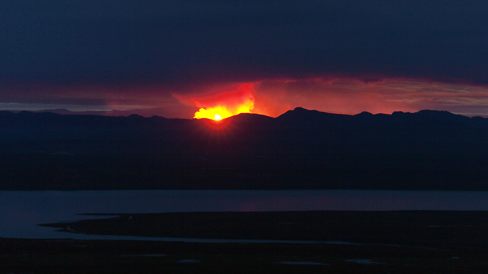
Holuhraun eruption at a distance. Photograph copyright by Eggert Norðdahl
Hi all, long time no see. Thanks for your patience. Since leaving for the north, about 10.000 VC comments ago, so much has happened. But, actually, it all started five days earlier, so about 14 days in “VC Calendar Time” but as all know that is un-measurable in Geological time.
When the eruption started (again) early on Sunday morning, 31 August, Junior phoned me about two minutes after it was first seen (Mila web 05:51). Plans were already in motion. Film. Make movie. Or at least get stock footage for the Hekla film. Some weeks earlier, this idea had picked up increased momentum, thanks to private support from Carl. By Saturday, 23 August 2014, I had already been in the air, filming over Bárðarbunga …
Further travelling plans were already in motion. I and my pilot friend Sigmundur tried fly up north on Monday (1 Sept) but ,as weather was unfavourable and we could not cross the interior by Visual Flight Rules (VFR), we had to postpone.
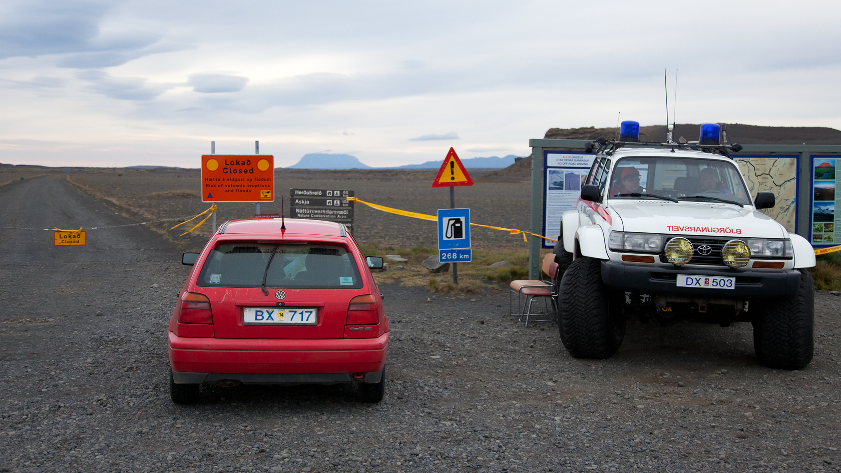
Waiting by the checkpoint next to the Icelandic Monster Police Car. Photograph copyright by Eggert Norðdahl
Then, I’m afraid my pilot had to go into hospital. But that was only for a check up, he was back two days later.
During those two days many brave pilots & photographers flew there and got some very good photos. By the time we got there, with two planes and four photographers on September 4th, it was dark as dusk, pouring with rain from huge-cumulus over the site. Then the first fountain appeared out of the murk – WOW! And I was not referring to the airline by that name. We were in company with two other planes but each flew different altitude for safety. All contained photographers! We took turns taking photos and video (the air was very turbulent, so stable video clips were all but impossible, sorry).
We stayed over the eruption site for one hour then left for Mývatn Airfield. Arriving there we saw crashed Dornier 27 off the runway. Nobody onboard was hurt, it had swung on landing. Thankfully, dear readers, we landed ok. We took on 80 litres of fuel, stayed two hours, but then left again for Reykjavik, via the fissure. It had stopped raining but it was rather dark. Immediately after landing I hurried home, started processing pictures/copying videos, sending some off to agency and Nick in England and also pictures to Carl at VC for you, readers. I wish I could say that this was straight forward, but a dodgy internet connection meant that it really wasn’t. They were still uploading when I went to bed at 02:00.

Fires at Holuhraun with trucks in the fron for size estimate. Photograph copyright by Eggert Norðdahl
07:15 rose to find that the connection had dropped and the upload had to start again. Then I kissed wife goodbye, finished writing photo text, then had Sigmundur come over with the other photographers in a jeep. Pick-up was at about 08:40, and we were off 15 minutes later for VERY LONG road trip up north. Needless to say, car was packed with stuff. Helpfully,we got news that the area had been totally closed to all. Gas. A real Doh! moment. But we decided to continue anyway, to go on regardless, we had our Media Pass and Special Passes, permission document, our camera gear was 100% in order, and weather for the coming days was good. We drove the 750 km out to Mörudalur, still to find everything closed but, to our amazement, when phoning local authorities in Húsavík, about certain closure details, nobody seemed know these exact details I was asking about! It transpired so many people were involved, that all were not up to date with what all others had decided or were doing. Needless to say I reported this to the authories in Reykjavík, in the hope that if it could be checked, double-checked and learned from. When calling Húsavík the next day, there was another person on duty and he had all the relevant info, on a notice-board before him! I do not know if my calls “put it there” or not. Ok, back to the Mývatn area. Checking in at a hostel, at midnight, we got the wrong building. It had beds, so no no harm done (but got 700 kr discount on second night though. (And that’s 5 of your US$!)

You’ve gotta LAVA this! Photograph copyright by Eggert Norðdahl
We saw the eruption glow reflected on the clouds just after midnight, so we drove out again to catch that from south of Myvatn area. Then it was back to sleep at about 03:00 hrs. Just 4 hours later at 07:15 we were up again. We drove out before 09:00 hrs, this time to the correct checkpoint. But it was closed as before. Everything was closed at the eruption site but scientists were there, and with fine weather and plenty air traffic. We were still 50 km away, and had no plane! I even saw Luftwaffe C-160 Transall transport fly over west-bound (flight GAF061) and heading straight to the eruption! Police from Vopnafjörður came by but the remaining hours were spent chatting and speculating with very nice Volunteer Rescue Services persons from “Vopni” there. Thanks guys, I know they read VC there! Then we got a tip that by going up a mountain, to Vestar-Sauðahnjúkur, off Kárahnjúkar dam, the eruption could be seen in “line of sight”. We drove out, two more hours by backroads, over Kárahjnúkar Dam (bringing back memories from 1992 when I worked on its design & building drawings).

Icelandic BBQ. Photograph copyright by Eggert Norðdahl
We literally we ran up the mountain, 1000 meter high (but only last 200 meters!) as light was failing. Arriving in dusk, the eruption was visible but there were clouds overhead. It was not very photogenic. We met a girl Park Ranger that had been forced to leave Hvannalindir, but was filling in at Snæfell Mountain Hut that weekend. We drove back in the darkness, three hours by the roughest back roads. We made it back to Mývatn at 02:30 hrs (note to self: next time, stay closer). Bed at 03.00 hrs after a small snack. Up again at 09:15 Sunday morning (a record breaking 5-6 hours of sleep) for the trip. Off for food and news, but no news yet. Packing all up, with everything stuffed into car. We decided to stick around until midday, Sunday, then head back. We were still clinging to the hope that the media ban would be lifted.
I began phoning “those in charge” at noon. No news. Phoned again. No news. So we decided to do some sightseeing in the Dimmuborgir and Mývatn area to pass the time. I will readily admit, we were not in high spirits. Driving 1200 km and having no media permission for the eruption site. Two full days of waiting. I was seriously thinking of calling it quits!

Fire at Holuhraun. Photograph copyright by Eggert Norðdahl
But at 13:54 hrs the ban was lifted. Yay, a flurry of action. I quickly recalled my fellow “sightseers” and driver back to the car. They bought some extra food and we set off quickly. Then we drove east, for the third time! Arriving at main checkpoint in Krepputunga, there were two cars ahead of us, also on the way to the eruption site, but we never met up with them… We followed, made stops on the way and photographed the surrounding mountains. Arriving in Dreki in early evening, we sought advice and instruction. Incredibly, a very nice scientist handed us his Tetra radio, and briefed us on procedures. Obviously, I became Radio Operator and Tour Guide instantly. Approaching the eruption it started to rain, and it rained for the remaining 27 km until we arrived. We found correct track in the sands, then the eruption came into direct view. It was small… Only 150 meters! And very silent. Only a quiet rumbling like large waterfalls. A strange and eery sound. But we stayed well off the lava and possible gas areas. Lava had entered river near Vaðalda, but it was silent. Light conditions did not allow any time to there, Instead we went for the main crater fountain and I managed shoot some video, before the light ran out. With the other camera I had, I took pics of others taking pics and videos!
The rain continued relentlessly and one lens soon became water-logged. Lenses don’t like water. It kills them. It fogged up (damaged, but repairable). I changed lenses and managed fill (almost) all available memory cards before our return to Dreki Huts at 23.00 hrs. In the meantime, two other jeeps had joined us, and I had became Group Leader for all (the others asked for our “group protection”). One car had a flat battery, but soon started again. Likely old battery having “off-road shaken syndrome”, where vibration loosens up old particles inside it and the voltage falls (by shorting). Otherwise we never got stuck in sand or otherwise. My driver is an old hand at driving in hostile mountain terrain. Back at Dreki at midnight, we were refused accommodation, briefly or overnight, so we had to set off on the highland roads in the dark, in the middle of the night. Two other cars were ahead of us and we had exchanged phone numbers, just in case. Not scary, we had very good car, but it took three hours to the main checkpoint (VEB made tent/hut). Only two rescue personnel were there on duty (new shift) and the four of us were invited to rest in our sleeping bags. One elected to sleep in the car outside as it was not such a cold night.
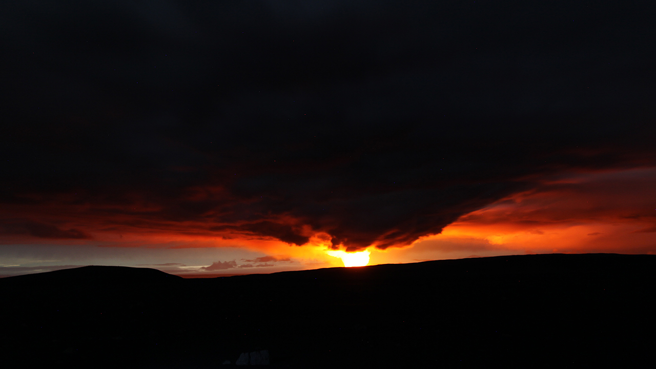
Holuhraun eruption at a distance. Photograph copyright by Eggert Norðdahl
Off again at nine, a quick coffee, and we said goodbye to the “Jökull” people at ten. Off to Möðrudalur and Hálendiskaffi at midday, for food, had lunch and then refuelled for trip back to Mývatn and Akureyri. Then I discovered that my jacket was still in the VEB made tent/hut, since 03.00 am last night! It was wet so I had hung it to dry on the wall and forgot it in the morning. In it were samples of New Lava, small stones for Petro Analyses (as requested by someone).
It took all day, Monday, to drive back home, 750 km along main roads. The following two days were spent copying and backup copying files, repairing camera gear, and processing photos to send to VC.
A good adventure. We had plenty of minor troubles, not to mention that we never were able buy gas masks or gas meters. These were all sold out. On Friday I got my jacket by mail complete with samples and my Hi Vis vest. Thanks Mr. Jökull in Fáskrúðsfjörður. Then I discovered probably how SO2 smells. Think Diesel motor fumes!
And thanks again to you all VC readers, for your tremendous support and inspiration on the Movie Fund project (I have lurked whenever time perhaps permitted, but have only read about 7,000 comments so far). I intend to film more in the coming weeks, and have worked on this practically every day since 23 August, so far financing myself, so contributions are very much appreciated.
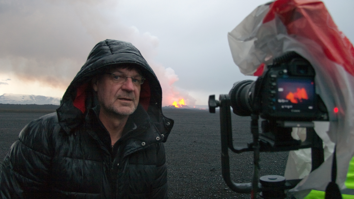
Tired, wet and happy. The Man himself at Holuhraun. Behind the scenes shot from the movie. Copyright by Eggert Norddahl
Your eye on Bardarbuga, Eggert Norðdahl, aka “Islander”


I hope your right Craig Heden. No one really wants Bard to go ballistic. I think they kind of like how it’s playing out right now except for all the SO2. Makes for a great story and tourism.
I like your stout version.
tremor plot just starting to show a little more activity…. hummmm ticking time bomb. Got to run hide for a few hours.
Brandnew pictures of the eruption:
http://www.lukas-gawenda.de/bildergalerie/vulkanausbruch-island/
Hi Lukas, hast du nicht diese schon vor einer Stunde gepostet?
Just as an quick reminder (as some people are asking about the behavior of the BB GPS), I did consider yesterday that the behavior of the 30 minute average will get more erratic (and the roller coaster ride will increase in amplitude).
I would find it hard to believe that the 30 minute average (red line) is jumping around just because of GPS errors (atmospheric issues).
My hypothesis is that this increasingly erratic behavior happens because of water (but we would need a radar flight to verify the amount of liquid water in the BB caldera. Water might be sloshing around (and you only need earthquakes generating the specific long wave vibration that can put the thing into resonance).
Either we have an large enough lake or there ice has lost stability and is on the move.
Now three questions for people with information inside IMO:
Do we know the exact location of the GPS (where it is installed on the caldera)?
Do we know if this drop in altitude is also matched by some kind of lateral movement?
When are we going to have the next radar flight (will they be searching for water?)
While you are at it ask about what seems to be gaps in the information released in their official ,increasingly vague ramble,press releases😆
DragonHissyFit: We do not take kindly to critisism of the IMO in the cafe. They are under tremendous pressure and far from whingeing about the content, we should be appreciative that they take the time to issue daily updates. K
A different Dragon chimes in → Unless you are prepared to offer a solution to your claimed issue, you would be well advised to consider the thousands of hours of research and study that IMO puts towards understanding what Icelandic systems do. They are quite literally, the best in the world at their job... which is protecting life and property for their citizenry. Not providing entertainment for us. We are a group of interested amateurs, we are not here to second guess IMO. They know their job and stick to it. About the only geophysical organization that I would put in their class would be the scientists in Indonesia. The rest pale by comparison.
Personally, I am quite offended by the arrogance of questioning them. If I didn’t have to clear it with the rest of the dragons, I would outright ban you for such insolence.
Criticizing is really easy but doing is another matter. You have to realize that that is something which is “on the verge” of the unknown – they’re doing their best and that’s something – dfm
yeah, that would be something, anyways it would be nice to know if the ice is on the move, or just going up and down (standing wave style).
Ok silly question, but would not the glacier behave like an iceberg in this scenario, so it would sit hard on the bottom in places even with 3m deep lake present?
Unlike an Iceberg, the glacier has a physical connection to the rest of the icecap.
Feel free to delete the comment?
What was said was said, the comment stands, as does the admonishment.
I took it as sarcasm; IMO statements are the exact opposite of vague & rambling. There’s a reason we call them ‘stone tablets’; I think the Troll was joking.
The troll thanks you for the benefit of the doubt but he screwed up,but he didnt imply IMO of not telling the truth when they said ice was on the gps at Ģrimsvotn.Double standard indeed,this post will disappear quickly read while you can.Of to Jon s Blog,Hi Jon😃😂😁😈
Just in regards to “stone tablets” the Ancient Egyptians wrote a lot on stone tablets including quite a few fables but neglected to mention how they built the pyramids!
Wow, someone have sand in their vaginas. Get off your high horses.
XD
“The rest pale by comparison”
(cover your eyes Boris!)
USGS?
the thing is that my math is quite rusty and I am not that sure about my calculations regarding the longest natural period of an seiche happening inside this hypothetical lake.
Assuming a rough 10 minutes average of the seiche (the two recent peaks with striking similarities), and and caldera lenght of 10km, the merian formula should give me something like an average water depth of 3.6 meters.
This is only assuming that the ice above the water is fragile enought that it would naturally follow the seische.
On the other hand the seiche explanation is worthy of attention as the last time we had such oscilations (on the 15th) the hypothetical natural period of the seiche was longer (almost 90minute to an hour) meaning just an average depth of 0.5-0.3 meters of any hypothetical body of water.
Interesting,but I do not understand any of it !😆
http://en.wikipedia.org/wiki/Seiche
all bodies of water have an natural resonance (an standing way). Main reasons why your swimming pool might just flood your house because of some random earthquake 1000km away.
This is also why tsunamis happen in pairs of waves (and thay take days to die off)
Like this then 🙂 http://www.liveleak.com/view?i=4fb_1397929225
Love the new avatar, Bev! 🙂
Ok, just to corect myself in my silly calculations above. I was considering an 60 minutes natural average of the standing wave of this hypothetical seiche.
This is actually not that wild of an idea. Please continue.
Yes please do continue as last quake seems to create some sort of waving pattern in the gps signal after a “steady” period. no pic included as it is not done yet but it’s this quake.
Wednesday
17.09.2014 18:09:52 64.619 -17.390 5.9 km 5.2 99.0 7.0 km ESE of Bárðarbunga
Sieche…
solutions→”solitons”… water… NOW I’m a little closer to my comfort zone ! And the thought of a caldera as some sort of gigantic Tibetan (or in this case, Icelandic) singing bowl? Wow… please continue.Solutions? I meant solitons.. confounded tablet!
I thought you had gone all DUNE on us – seitch filled with water 🙂
There was a Earth Sciences Facebook post that is now gone, if I recall correctly stated the GPS was 1.5 KM northeast of the center of the deepest subsidence
Scratch that
I found this translation on the website so the GPS is 1km southeast of the deepest subsidence
http://jardvis.hi.is/sig_bardarbungu_maelingaflug_13_september_2014
“The measurement yesterday shows that the greatest himself is now 23 feet about 1 km northeast of GPS monitoring stations established for Thursday”
Thank you, Ian! That has answered a question many have had! Well done! 😀
Why water? Water is more likely to slosh from side to side if shaken, rather than up and down. Why not magma? I should think that if you shake gassy magma enough, it will release the gas and expand. I’m thinking soda in a bottle…
Yesterdays panoramic view abit more edited: http://i.imgur.com/ODXr50P.png
Cloud looks a bit awkward because it’s missing that top part in colouring http://i.imgur.com/FFlbxyv.png
New IMO update out…mentions
“GPS monitoring show irregularity in the crustal movements over the last few days. This sign could indicate that magma movement under Bardarbungs is changing.”
That is starting to sound like,”we see some things that don’t match what we think should be happening and we have known this for days(or weeks) but we should start saying something to cover our bases”kind of talk?😄
DragonHavingSecondHissyFit: Please note my addition to your previous comment! K
DragonRumble: Troll beware! Please heed the warnings (and do remember that some Dragons are partial to a pot of TrollStew every now and then! 😉 ) / Pyrite
RT, I agree with Kilgharrah up above… please cut out the innuendo concerning IMO. It’s not that anybody is above criticism, IMO included, but none of us long-timers here have much patience for amateurs coming along and dissing the professionals in this situation. Just imagine yourself being in their position. An awful lot hangs on their words and they are professionally held to account for it. Just cause you’ve got all the freedom in the world to waltz in here under a pseudonym and thrash any one of a million theories without any accountability whatsoever does not give you the right to criticize the intentions of the public officials, who btw, have a great track record.
As i said redact the comments and I will move on and learn from the experience?
Why should it be necessary for the dragons to warn you twice then? Just learn a bit faster from the first experience.
hen
Got home tired… the beak is always sharper then…
Next time I shall be more polite… perhaps.
hen
To further support the IMO, they have been using GPS to evaluate magma movements for weeks now; it isn’t as though this is something new. They’ve been very consistent.
IMO have historically been VERY very good – at saying what they think is actually happening and making sure that people remain safe – that is priority 1 for them – covering bases is fine if the IMO think those bases need covering then the odds are that the system is changing, so it sound more like a ‘we may need to revise the plan, be ready for an updated plan if something does change’
agreed!
Rhyolitic Troll you have sometimes been annoying me also with some of your posts but up until now I have tried hard not to mention that out of politeness. Please R-T, if you don’t agree with people who are doing their very best in a professional way to help ICELANDERS to be aware of any dangers, then it would be polite to keep your thoughts to yourself.
As anyone who has been on here a long time will know, I have never spoken as straightly as this to anyone before and really hope I never do again but there are limits to my patience.
Adios “and like that he was gone”
Thats your choice. If “we” had wanted you gone, that could have been easily arranged. I even have that ability myself. Differing points of view are welcome, but continuously deriding one of the best in the business is a bit much. Personally, I came down a bit heavy on one agency due to outlandish claims about their volcano, but that was because they were sluffing off their job and quite literally, implying that their volcano was not there. Had it not been for the professionalism of IMO and other agencies for comparison, I would not have had a leg to stand on.
Well, you don’t have to up sticks and leave. We are open to all comers here. Just tone it up a bit.
edit, and I must stop saying we. bad habit.
“We” is fine in this instance.
Don’t want you to be gone, just moderate some of your comments pleeese?
Agreed! (Also I must say that’s the first time I’ve ever seen Frances riled).
Frances hates disrespect of anyone. I personally see no need for it. Also I have always seen great respect shown by the Icelanders on here to comments that can often be inaccurate as my comments frequently are.
totally agree
May I also add that IMO have to be extremely careful about what they publish; any slightly unguarded or unsubstantiated speculation from official sources wll be leapt upon by certain sections of the world media, who will gleefully exaggerate and/or invent their own lurid scenarios, with possible panic of the public.
I am unsurprised at the language used in these bulletins.
I think IMO may act on the side of caution at times, but I don’t think they have ever held back anything from the public. They have hidden nothing…they make all their information public. I think they wait until they may have a better understanding on the situation to say something. This is uncharted territory, and I respect that they wait to make sure they get it right, rather than jump the gun and put something out that may turn out false in the long run. If they did that, people would stop listening to them. Things are trending and moving; they (IMO) are just trying to figure out exactly (to the absolute best that they can with their considerable experience) where this is heading.
This is a protracted event with unprecedented monitoring. Like true scientists, they are refraining from making inferences and predictions from a set of measurements that they may be seeing for the first time, or haven’t seen with enough frequency. I trust that every word is carefully chosen to accurately transmit their knowledge and their uncertainty.
Exactly what I meant 😀
DING! (pomans and helleborine)
I don’t control the points, but I nominate both of you for 3 pts each.
{finally, someone gets it}
😀
The Icelandic police working hard to keep us with the best view 😉
LOL…yeah, I just saw his hand on the lens 🙂
I hope they were wearing gas masks! That stuff must be just horrible.
I think that is mostly fog, the toxic stuff is blowing westward, could be wrong though.
I think that is so. Please see: http://earth.nullschool.net/#current/wind/surface/level/orthographic=-3.51,45.40,965
Does anyone have any idea when the wind is due to change and blow the fog away?
Check the IMO Weather page – I’ve just had a look and the wind is pretty steady from the east for a few days, but it will stay cloudy and rainy until Friday. Don’t know about the fog though.
In England we don’t get rain and fog at the same time, I have known it in Scotland though, (hence the term ‘Scotch mist’) and I would assume Iceland could have very similar weather because of the mountains and proximity to the sea. I hope the view will soon improve but sadly I suppose it must be expected in the Autumn, although down here on South Coast of England it is still 25C. An amazing day.
Yup! Warm up here on Salisbury Plain too! I know what you mean about Scotch mist, and I’m also not sure about Icelandic weather – I imagine it will be like the Highlands with gusts of fog, rain, fine mist and sunshine all within 30 minutes. Throw in the glacier and they must get amazing weather systems. I expect Irpsit or Islander will be along soon to let us know. 🙂
Scotch Mist is rhyming slang, ask Mr Whyte and Mr Mackay 🙂 🙂
I used to live on the west coast of the lake district, with a canny view of Scotland from the bedroom windows over the Solway firth, Sea in front, mountains behind, similar weather to Scotland and Iceland at times, if you don’t like the weather, wait five minutes!
“Regulators in the UK are investigating whether to force United to divest itself of Whyte & Mackay due to anti-trust concerns over Diageo’s dominant position in Scotch whisky production.”
http://en.wikipedia.org/wiki/Whyte_and_Mackay
It also occurs on Dartmoor, it is the weather system of highlands. Essentially, the clouds are low enough to cover the high ground, which is why the wind doesn’t blow it away. Instead, you get periods of slightly clearer and slightly murkier if you stay in one spot.
Soz Frances, but here in Whitby it’s misty and drizzly for the last 5 days. You’ve heard the phrase “like a wet weekend in Whitby”. Well here we are! Maybe I should move south and stop moaning.
Ah but I have heard Whitby is beautiful. One must pay a price for living with beauty. 😀
And here’s me thinking Scotch mist was whisky… well, that’s a window into my subconscious that isn’t surprising! 😀
When I lived in Scotland for 5 years it was always the weather being referred to, I never heard it associated with whisky.
Which just goes to show the association of ideas in MY mind because I’m sure that’s the only location in which this particular association exists! 😀
When we visited Iceland in July, we had the bizarre experience of driving through fog on the south coast and in and out of fjords for 2 hours, then emerging from the fog bank into about 5 fields’ width of bright sunshine and blue skies complete with farmer harvesting his silage on a red tractor, then back into the fogbank, followed by another 2 hours of miserable weather and very limited visibility. We stopped in a small town (name forgotten) for coffee after following the road across the sea end of a fjord and were astonished when we saw a wide sand bar (with road at centre) on postcards in the coffee shop – it was only possible to see for about 10 feet either side of the road & we had to watch out for the suicidal sheep the whole way across.The fog was accompanied by drizzle (fine rain). I believe the Scottish word for this kind of miserable weather is “dreich”.
Forgotten or unpronounceable? 😀
(After all, the human brain tends to dismiss/downplay traumatic events.)
Right. I managed to dig out the Road Atlas when I got home – it was Breiðdalsvík. Someone posted a picture of the awful scree face dropping away from the ring road on the south coast a couple of days ago. We thought we’d probably missed lots of amazing scenery, but I’m also thinking the fog might have spared us lots of hair-raising views along the ring road too.
On the other side, we can take a better look on earthquakes diagrams, Lets check IVON plot.

It Is so different then yesterday for me. Many, many regular tiny quakes not noted by official oficial earthquakes. Can it be harmonic tremor ???
I could be mistaken but it appears the resolution is much finer than other days so the small ones show up when they do not on other days. the one at 11:09 was a 2.2 that would not have shown up at all on other days
I am afraid I tend to agree with Eldgya, I haven’t seen this many small quakes on Bard before (well since before the rifting started anyway) and in my personal view I doubt it is anything to do with resolution. I just think Bard is having a very unsettled spell. I don’t think it is harmonic tremor as I have seen in from El Hierro (my only real experience of it).
Harmonic tremor has more … well harmony! This seems much to disorganized but I am a total amateur so don’t put too much trust in me. 😉
If you look at the quake at 16:14 on this plot from yesterday it was a 3.7
https://www.flickr.com/photos/15522274@N04/15039339867/in/photostream/
If you look at the quake at 11:10 on this plot is a 2.2
This shows the scale difference and when they upscale the little quakes disappear
Sorry wrong first link
I always thought the scale altered as more lines appear on the plot as the time goes on. Am I wrong on this? Certainly if you look at it in the early morning the quakes look massive, even the small quakes. The chart above is at almost 10:00pm whereas today’s one is at around 5:30pm. So the quakes do have a smaller scale I agree. Add to that the fact that you are comparing two different charts, Von against Dyn and also different days then it isn’t a specially good comparison as each station picks up a different signal of the same quake. Again I say, I am no expert on this but I have still never seen so many small quakes in Bard as today’s. I may very well be wrong but can’t see that so far from your arguments on scale. I am though and older lady and my kids call me dim when I can’t understand their logic. 😀 😀 😀 So nothing personal here Ian.
No I understand what you see since I believed the same thing for days until all of the little quakes disappeared as the day went on lol 🙂
They pattern of small quakes intrigues me and every time I wanted to look at them it became so late in the day they we gone!
You may be indeed correct about todays but there are other plots that show much more noise than usual along with VON, I think when a M5 quake happens they rescale and since there is no M5 toady, so it looks different??
Just guessing 🙂
too funny, just as I say that here comes the M5
so I guess we will know for sure
Yes, the scales changed on all of the plots
Haha, I agree Ian. Bard must have been listening to the discussion and thinking I will show them!
By the way, how did you get hold of yesterday’s drumplot? I have often wanted to check them for comparison. Did you have it saved or have I missed some way of retrieving them?
From the last post, I remembered someone posted it, thought it was VON
IDYN plot has a small slashes which seem me to be related to automatic noise reduction. I prefer natural beauty given by IVON.
I can’t reply directly to your later comment, Frances, where you said, “I always thought the scale altered as more lines appear on the plot as the time goes on.” You’re right. The re-scaling occurs because the frame of the plot doesn’t change; it just has to accommodate, in the same space, more information as the day progresses. If the frame expanded at the same rate as the information it encloses, it would eventually be so horrendously huge you wouldn’t be able to fit it all on the screen! As soon as the drumplots turn over at midnight, I’ll start taking screenshots of IDYN throughout the day and put an image of them together – that will prove that you are right! 🙂
The ‘fuzzier’ ones are echoes of distant earthquakes and so are not attributed to this SIL station. I think a visual comparison explains this better than I could in words alone:
Thank you Mopshell. This post is very helpful for a newbie like me.
Oh I am so glad, LambSoup! I’m just passing on what I have learned since being here and hoping it helps others. 🙂
Not sure if anyone of you have seen this amazing video of the Holuhraun volcano yet?
I found the video here first: http://www.mbl.is/frettir/english/2014/09/17/this_is_only_the_beginning/
Click to access J40p147-168.pdf
Interesting article in Jökull from 1990 by Helgi Björnsson and Páll Einarsson on the Vatnajökull system.
Put out for information by Jarðvísindastofnun HÍ
The subglacial eruption back in August on the ridge to the SS/SE of Bárðarbunga probably drained the meltwater into the isolated divide between Kaldakvísl and Grímsvötn rather than into Grímsvötn directly – there is a huge deep valley there which could hold a lot – the water may refreeze, or break out either to Jökulsá á Fjöllum through the pass between Bárðarbunga and Grímsvötn, or over the saddles to the west, either to Kaldakvísl or Skaftá (my speculation from looking at the subglacial topography, suspected location of eruption and interesting line of small earthquakes S/SW of Bárðarbunga subsequent to the subglacial eruption).
No, all went to Grimsvötn.
Do we know that? I have heard it asserted, but the only evidence cited that I have seen was that rise seen in Grímsvötn at about the same time.
Problem I have always had with that is the topograhy – I don´t see a path for the water from the claimed site of the subglacial eruption to get to Grímsvötn without going uphill for several hundred meters at some point, and there is a gradient down either to the northeast or southwest – and the water didn´t come out Dyngjujökull, so that leaves the southwest drainage and there is a ridge blocking the water from getting to Kaldakvísl.
ergo.
fun conjecture anyway
There was a series of small linear earthquakes to the southwest so something was happening down there for a few days.
I meant in 1996 it did. Did you mean now?
Yeah, I meant the conjectured subglacial eruption on the SSE/SE side of Bárðarbunga back in late August this year
Ok, yes. But then we who observe “cauldrons” make one fail. Maybe also involved might be ground surface subsidence (like at Holuhraun) and no real runoff. Also I think there was small eruption already inside the “caldera” walls. Do “movements of the cork” account for the middle of caldera depression, have axis with (in line with) fissure from Barði caldera, or that be mere co-incidence. Or was this caused be (small melt) eruption, like 23 Aug, when IMO declared and eruption, but MTG stated there was none. Then others admitted there had been SEVEN eruption already in this “episode”.
Dunno about that, they know the watersheds better than we do.
Yes, right, maybe. They say just maybe.
But personally I do not accept all as fact if Mr. Páll Einarsson (of Katla Connectiion fame is involved) but the other guy is the Glacial expert and “re-freeze” does not happen much here in Iceland but on surface.
To explain: I happens glaciers in Greenland and Iceland are different. Its mostly “Hjarnjökull´s” in Greenland (solid block Icea), but Iceland´s glaciers are all “Þíðjökulls” (not frozen solid, rather like grainy pellets) and meltwater runs off quickly, refreze is therefore mimimal and (much higher temps here) and on mostly surface only. I was involved in reserch into this type of Glaciers, in years 1984-1992, trying find old WW2 (recoverable) aircaft. Yep, I was contacted by one or two of Greenland expeditons on this and told them of the Long-Wave radar (used here in Glacial research at the time). That found the P-38 Lightning´s eventually.
But it someone asks about the C-54 Skymaster “Geysir” TF-RVC in Bárðarbunga. Its not at 200 meter depth as Dr. Harladur Sigurðsson stated in one interview. Its already at bottom of glacier, already since 1990´s and lost to “grinding”. No eruption will melt enought for that to re-surface.
So, GL, I do know some on these matters, but not expert.
In effect, a pellet mat? Quite Interesting. That would make their interaction with quakes all the more bizarre… possibly even fluid like in large quakes.
Note for all:Observe that *starving artist* provided a measure of justification for a contrary opinion. That goes a long way around here when making an argument… that or citations backing the point.
In so doing, we learned quite a bit more than some simple comment.
It is very very likely we had coffee, if not beer or six, back in ’85-86. Did you hang out at OS at all back then?
nope, research was my study only, I was mostly at engineering firms, making construction drawings. *not official research*
Ok, small world.
I was working summers at OS working for Vatnmælingar up in Öræfum and around Langjökull mostly. We were shorthanded and several of the glaciologists working on the radar stuff did some work with us between their tours.
Yes, in effect yes, much less “blue ice”, more like “snowbergs”

but you of course can find blue ice, but most of Icelandic glaciers are rather soft,
and melt quite fast (and runoffs are quicker).
Icelander, would the reason for the different structure of the glaciers in Greenland and Iceland have anything to do with the ‘type’ of snow one gets in the mountains. More pellet snow perhaps rather than softer flakes?
no, climate I guess. Heavy frost (-30/-40´s C) is more common in Greenland and the icecap is much larger and very thicker, pressing it further into “blue ice” (many km thick). Here is Iceland we usually rarely get frost below -20C., and probably thickest “ice” is around Bunga (800 m).
Ah yes, that seems logical. Iceland is an island so although very cold certainly wouldn’t get the same degrees of cold as Greenland.
I wondered about this since it is evident that there is a fairly constant and steady runoff from the glaciers that feeds into the rivers. On and that blue ice is really pretty! 🙂
“On 14 September 1950, a Loftleiðir Douglas C-54 Skymaster (registered TF-RVC, named Geysir) crashed into the Vatnajökull glacier. The six occupants that had been on the cargo flight from Luxembourg to Reykjavík (the first service for the airline on that route) survived, but could only be found and rescued on 20 September, as the location of the crash site had previously been unknown.”
http://en.wikipedia.org/wiki/Icelandic_Airlines#Accidents_and_incidents
Six day stranded out on the Glacier… fun fun fun (/sarc)
Yep, and US Air Force flew in an C-47 on skiis, tried save crew but abandoned it damaged.
Then Loftleiðir Ltd (the airline) rescued that next spring, and towed it off.
And had that repaired, converted to passenger version, and made a small fortune.
Interesting you just told that all, it would make earthquakes indeed act out more strangely.
i was watching Ice on Fire yesterday and remembered these parts while reading this.
at 22:30 it’s those planes Strarving Artist talks about 🙂 also a docu worth a watch 🙂
31:00 about grimsvotn
No correct sCyborg, no wonder, this docu film does not shows all correct.
I am THE Expert here on these matters.
– at 22:30 in this film they show parts cleanup of USAF Grumman SA-16 Albatross (from 1952) in Eyjafjallajökull, Gígjökull in 1990´s (I went there for another cleanup of same plane 1992) but Chinook was used later (1996 or later). Rest was washed away in year 2010, if somthin was left. it crashed in same spot as Ejo main crater eruption happened.
but before they shown currect USAF C-47 in Brown colours (digging it out 1951) but wrongly they also show Flugfélag Íslands/Icelandair Douglas C-47 on skis, but they were mainly used as such in Greenland in the sixtites/early-seventies (but not Iceland in 1950´s as shown in film).
But “Geysir” will not return this way. It drifted to bottom and likely “shredded” to scrap.
It took the Albatross over 20 years to drift down, in small parts, all torn apart. These you saw there was main gear, other gear was cleaned out earlier. These were to stron for Glacier to break (pull apart).
Man these glaciers are some scary place.
I remember seeing a satellite picture of bards crater with to the right of it a pretty long marked snowmobile track.
Isn’t that dangerous? is the ice only connected by the snow for the most part, and compressed between ridges and such of course but for it to act this way you would almost say you’re walking at icebergs on dry land.
I don’t recall seeing this image here before…but, if was already posted, I apologize…it’s just mesmerizing.

http://earthobservatory.nasa.gov/NaturalHazards/view.php?id=84316
I think I saw something like it, but it was many days ago. Thank you for this . . . it answers a question that’s been nagging at me. 🙂
It’s glorious, thank for this! I hope they publish an update soon. 🙂
Would the agitated Vonaskard tremor plot possibly be showing us activity on the other side of B. Tungnafellsjokull has had a cluster going too. Maybe small but too much movement underground to dismiss lightly, especially with B bouncing around next door like a bad neighbour. Just a thought…
Squeaky bedsprings?
Nah, it’s those sharkcanoes on their magma trampolines – I posted a picture of them a page or so back. 😀
Wonderful post Islander ! I just can’t stop looking at the pictures. What an adventure. Thanks. A lot.
takk, takk!
are you going to change your name back or will you be starving until the dalek BBQ ?
no, no, just untill next post is up … 😉 🙂 😎
I can not manage wait for BBQ´d Meat Hat
by that time I probably whould get more than tolerable African hungry look …
Iceland met office says of central highlands near the eruption area : “sandbúðir” so likely a long-lasting sandstorm.
Sandbúðir is old IMO station, connected to highland research because of damming project
I thought it was long abandoned.
Interesting background on Sandbúðir. Going by this web page, it looks like it’s still sending out live data:
http://www3.vegag.is/faerd/weather1.html
Automatic station I guess…
I read so many things the past few days about mom Barda (which appears to be changing) and the starting point of George (the nickname I gave to the dike) that I do not know what to think. 😐
Well, in the past few days, nothing much has REALLY changed actually. 🙂 George is just doing its thing, while mom Barda keeps rolling in her sleep (not a very deep sleep while at it). 🙂
Is my understanding, however, that the starting point of George is not certain, therefore, if it is linked with mom Barda and her digestive disorders
I think the point of origin is pretty nailed down for the dike. Even the “paper which can not be linked” thinks Bardabunga was the starting point. And it has the most plausible elaboration of the events and forces that I’ve seen.
Je tolère Google translate mais je ne l’apprécie pas du tout 😦
no worries, I’ll try a summary – tout les gens pense que Bardabunga est la source de George 🙂
You can look dynamically at the dike progression since the beginning of the unrest on August 16th. It seems pretty clear. Especially if you link it with the subsidence of the caldera.
Absolutely – anyone watching this from 16th August saw that progression.
I can see the ground! (note illogical sense of achievement 🙂 )

Poor R2D2 … lost in the fog
“Lost in the Fog” – a great champion thoroughbred sprinter. Died at the age of 4 from inoperable cancer.
At least R2D2 now has a small companion with him so he’s not alone in the fog. 🙂
I can really understand that illogical feeling too! Fog for so long is a nightmare to me. I think I would be a depressive if I had to live in some parts of Iceland. At least I would in the winter. Thank goodness they have volcanoes to lighten the gloom. 😉
I think the ideal must be to spend Summer in the Northern Hemisphere and then Summer in the Southern Hemisphere… if only I had the wherewithal to do so!
Lukas, that low angle aerial shot with steam rising is prob the finest pic i’ve seen yet, thanks.
Also, Mops and Frances, do we credit IMO in comments, if the graphs have the imprints of the sources on them already ?
is looking like Iseland outdoors here today…and cold front hasn’t even blown in yet
I always say better to be safe than sorry and credit IMO anyway. Actually I pondered the same thought yesterday but noticed the legends weren’t that clear.
Wouldn’t want to annoy any wandering dragon. 😉
😀
Not annoyed, just attentive. Eyes are good things. They allow us to see. Interpretation of what we see is a subjective issue. Some see better than others. You are apparently in the “better” category. No harm in that!
Where are you desert rat.
Such a beautiful day here.
I credit in articles, but never in comments as long as the images have their logo.
Thanks Carl, nice to have the fine point cleared up. I have always been one to err on the safe side.
By the way, annoying a dragon was in jest, hence the wink smily.
So far I must admit the dragons are more than fair and I for one are really thankful we have them because my memory can be poor and they are good enough to correct things for me if I forget.
Definitely here be friendly dragons!
I second that wholeheartedly! 😀
It’s a fair comment desert rat and I must resolve to credit IMO more conspicuously in comments in the future.
Thank you for this compliment!
http://www.lukas-gawenda.de/bildergalerie/
Very big quake just now
Yep definitely a big one inbound, 5+ in that region or southwest of Bard.
where are you seeing that?
On the drumplots. Check the link under Bardarbunga info in the heading above.
Thanks 🙂
EMSC
2014-09-17 18:09:55.022min ago 64.60 N 17.27 W 2 4.2 ICELAND
Much bigger I think. I agree with you Don on the likely size.
IMO very quick on this one. Showing a 5.2
Wednesday
17.09.2014 18:09:52 64.619 -17.390 5.9 km 5.2 99.0 7.0 km ESE of Bárðarbunga
So now a dyke is opening S of the connector between Bard and Thang ?
Not necessarily. There’ve been numerous quakes on the ESE corner of Bárðarbunga – I just checked and there have been 15 ‘quakes of M>3 there since August 23rd.
Have they changed the camera angle? Seems like I can not see at all R2D2
When did you last look? I thought the fog was so thick the camera hasn’t shown anything since lsat night.
I narrow my eyes to see lollllllll
X-ray vision? 😉
Hi Alze and all, Just catching up with the blog . . . I was awake at 3-4 am here, checking it and various plots. I guess I am addicted. I can see only heavy fog on the Mila cams—as the weather there is reported to be—and the line at the edge of Vadalda). R2D2 is lost in the fog, not even his lights show. . . . If a dyke is opening to the SW of Bard, Jon’s prediction will be right on the money.
There isn’t any dike opening to the southwest. And let’s be thankful for that. ´
That’s the region of much longer and larger volume fissure eruptions, and also on the way to all the hydrodams and populated areas.
A second George? I remember having raised the question a few days ago
hmmm, don’t undertstand your question…
George is the nickname I gave to the recent dike 😉
Just call it a dike, please!
Maybe what Helleborine is trying to say is this: It is probably best if we all use the same names for geographical and geological features while communicating on this blog. As you know, it is difficult enough to communicate when we share a common language. More so when we do not share a common language. Avoiding nicknames might help us communicate more easily and prevent some of the, “What are you talking about?” that occurs. 🙂 {Maybe I should shut up and let a Dragon comment; if so, edit at will, of course! My family used to use tape on my mouth! 😉 }
I think also see occasionally top of plume in the center of the camera … hence the question whether the angle of mila 1 had changed
I believe they changed the angle four or five days ago so R2D2 is only visible on camera one now.
Er… correction: only visible when there’s no fog or vog! 😀
Ah, it’s the rough with the smooth! 😀
No drop!
Just starting a drop now. Not sure it can be related after so long though and quite likely to go back up again just as quickly.
LOL, I like this nick!
Tremors rising at Dyn again
Hi everyone by the way, been watching and learning for a while now. Brilliant site, thanks.
Hi Jenny and welcome! Have a coffee on the house: [░]> Where in the world are you?
I think, if this eruption stops, and another one starts, we might see it happening under the glacier in Dyngjujokull, just about 3-4km from its edge. Plenty of earthquakes have occured there, and the ones today show an interesting alignment. But only a speculation thought.
I had wondered if this is what happened last night; i.e., what we saw on the Mila cams was the snuffing out of eruption due to water flow and instantly forming ash which coincided with fog thereby creating poor visibility. If an eruption surfaced south of Holuhraun under DYN (due to cluster of good-sized quakes yesterday), would the water have flowed downhill to the north and over the eruption?
Just my newbie musings.
Given that the eruption is centred in craters that are now 30-70 metres tall, that would have to be some flood to even get to them let alone snuff out lava recording temperatures around the 1000°C mark! 😀
Just soz I know what to look for (in case nobody else is, haha), IF a large event occurred under the sitting-on-the-ice gps, we would see it rise up (maybe way up in the sky!), but before that it would take many hours to punch through (or push up) the hundreds of meters of ice. So I guess we’ll be looking for it to rise, not fall.??? *obviously not an expert*
If you think about how the Gjálp eruption started and assuming that the size of the (possible) eruption was similar you would see the GPS going down until a hole punched through the ice. That’s my opinion anyway.
Well, it would also probably malfunction quite quickly if anything happened, and so there would not be any rise or fall, just no updates. 🙂
Oh but I’m hoping that, if there’s an eruption from the Bárðarbunga caldera, the GPS wil rocket straight up in the air while recording the highest GPS rise ever! 😀
@ Lukas – your pictures are wonderful. I especially like the one that shows what appears to be “a tiny toy airplane” toward the bottom of the picture. Really shows the scale of the eruption.
Thanks! 😉
http://www.lukas-gawenda.de/bildergalerie/vulkanausbruch-island/
I think the ‘tiny toy aeroplane’ may be the one Islander was in that day.
I couldn’t see him waving 😀
*waves now!*
Yes, he confirmed it further up the comments. My inference is that the two planes seem to have flown out together.
No S wave on that 5.2?
Well at least not on all charts, an indistinct one on other chart. Material must be ductile.
Implications?
Eq in B must be bordering on magma or semi soft evolved magma at friction point. Depth indication of where magma is in relation to plug.
Or the earthquake is directly under the seismometer.
Its not so clear the S wave, but its there.. BORG Station.
http://imgur.com/YujfE0U
Here is a map of EQs, zoomed in on Bard, from http://www.bardarbungavolcano.com (the best map I’ve found). . . . What is “Thang” please, I can’t find anything called that on any of my maps.

An other one here
http://earthquakes.volcanodiscovery.com/map/Iceland
Thangsvotterngaldang ? (no idea) is the satellite cauldron escarpment due west from northern tip of Bard caldera.
Can’t find the map with the names on the peaks out there, most of the ones i have just say Sattelite, but Carl picked up the first quakes of this sequence out there…..
I don’t know how to add a minion, but my view with water
and with fire
Thanks!! How far back did Carl pick those up?
PS have been searching archives, haven’t found it yet.
Nite all, off tae bed with a wee dram and a bowl of mint ice cream. Will catch the morning crowd at 6 🙂
So, if I read correctly, the drop in the BB ice cake is 60 cm over de last 24 hrs.. Is it me or is the angle of the drop slowly increasing… (or is this to few data points to state)..
A new post is up: https://volcanocafe.wordpress.com/2014/09/17/the-long-wait/
So winter is coming which makes for good fictional writing and exclamations of joy where I live due to the high temps. I’m starting to wonder about Bardy if snow begins to accumulate will that help mitigate eruptions… Does the season matter with Icelandic volcanism? Probably too little but thought to check with the experts!
Thanks, Dave
I’m thinking snow is like dandruff to a volcano, even a glacier’s worth of snow.
New post is up!
https://volcanocafe.wordpress.com/2014/09/17/the-long-wait/