
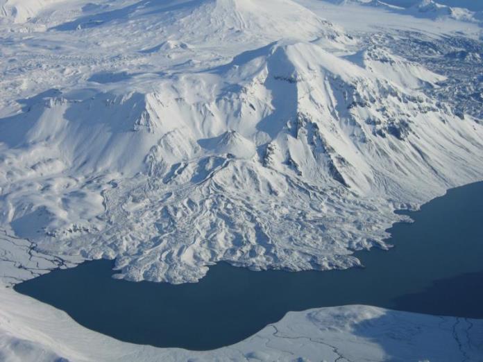
Emmons Lake and Mount Emmons, Alaska. Photo courtesy AVO, July 1987
When putting together a quick post on the most recent Pavlof eruption, I came across its home, the previously unknown (to me) Emmons Lake Volcanic Complex. Like the Katmai Volcanic Complex or the volcanic complex that contains Kamen, Tolbachik and Bezymianny in Kamchatka, Emmons Lake crams multiple active stratovolcanoes within a few tens of kilometers of one another. Like Katmai, this one also has a caldera, home of at least four major caldera eruptions over the last 350,000 years.

Map of Emmons Lake area from USGS, Preliminary Volcano-Hazard Assessment for the Emmons Lake Volcanic Center, Alaska, Report 2006-5248, pp3
Emmons Lake Volcanic Complex is named after a crescent-shaped crater lake mostly filled by subsequent stratovolcanoes. It is located some 35 km E from King Cove, 45 km NE Cold Bay, and a mere 960 km SW from Anchorage AK. The surrounding communities are primarily fishing villages, supporting tourism in local National Wildlife Refuges, and providing Air Traffic Control support for civil aviation traffic on the Great Circle Route down the Aleutians. There are probably less than 2,000 permanent residents with a 50 km radius of the complex. Cold Bay is described as a regional transportation center.
Introduction

Major volcanic features of Emmons Lake area from USGS, Preliminary Volcano-Hazard Assessment for the Emmons Lake Volcanic Center, Alaska, Report 2006-5248, pp4.
The most significant feature in the area is multiple overlapping calderas, the largest of which measures some 9.5 x 17.5 km, one of the largest caldera complexes in the state. This caldera complex has tens of km3 of associated pyroclastic flows ejected during multiple eruptions.
There are at least three nested calderas in the western most portion of the complex formed during vigorous volcanic activity in the area over the last 400,000 years. There are a variety of intracaldera vents, cones, ash and lava flows in, breaching and extending outside the confines of the caldera walls. The farthest east portion of the caldera is punctuated by the cone of Little Pavlof volcano.
The “Gap” refers to a 9 km wide breach in the south wall of the caldera complex. It contains at least four “geologically significant silicic welded tuff units that have flowed through the gap within the last 234,000 years.”
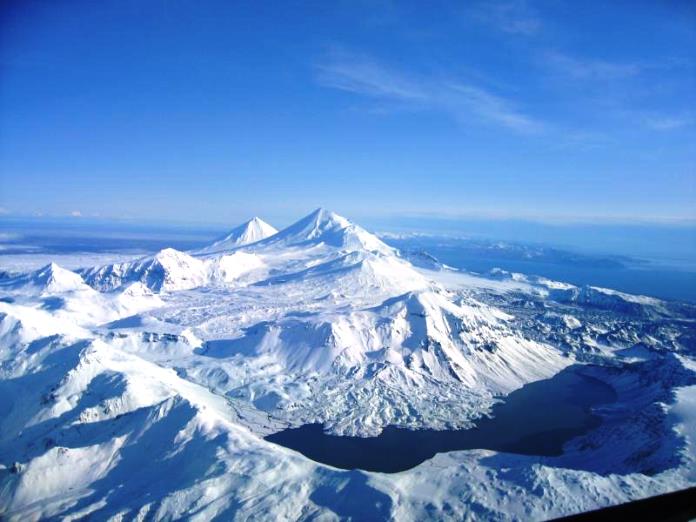
Emmons Lake Volcanoes, photo courtesy AVO, April 2005
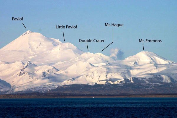
Major stratovolcanoes associated with the complex include Mount Emmons, Mount Hauge, Double Crater, Little Pavlof, Pavlof and Pavlof Sister. Of these, the only cone that has no known historical eruptions is Mount Emmons. Everything is historically active, with Pavlof among the most active volcanoes in the entire state. These sit in a line on the order of 15 km long. https://www.hsdl.org/?view&did=26134
Eruptive Activity

Major volcanic events of Emmons Lake area from USGS, Preliminary Volcano-Hazard Assessment for the Emmons Lake Volcanic Center, Alaska, Report 2006-5248, pp7.
It appears that the complex was active well before the first caldera forming eruption some 400,000 years ago. Since then, there has been some 3 – 6 caldera forming eruptions. Estimated dates on these include 294,000, 234,000 123,000, 100,000, 30 – 50,000 and 26,000 years ago. Rhyolitic ash fall deposit from this eruption has been found some 1,700 km NE in the Klondike region of Canada. These were vigorous eruptions that produced highly mobile and very hot welded tuff. Some flows are found over 35 km from the source caldera. The most recent caldera forming eruption ejected pyroclastic flows that covered over 3,000 km3 and flowed up to 60 km from the caldera.

Map of Dawson tephra distribution, from Froese & Westgate et all, 2002,
Two caldera forming eruptions were identified as the source of something called the Dawson tephra, 15 – 30 cm thick loess deposits, found in valley bottoms in the Yukon. One of these was some 238,000 years ago and the most recent one at some 26,000 years ago. Both were defined as ultra-Plinian events with plume heights in the 30 – 40 km range. Estimated output in each eruption is above 50 km3 with widespread ash dispersal. Both eruptions created currently observed caldera structures. The most recent eruption emplaced rhyolitic pumice flows covering a minimum area of 2,500 km2. Chemical analysis of the second eruption pyroclastics match very nicely the Dawson tephra found in the Yukon Territory, Canada. There is a question in the paper why a layer of the Dawson tephra has not been recognized elsewhere in Alaska. An answer might be that due to the vigorous volcanic, glacial and earthquake activity of Alaska between Emmons Lake and the Yukon, it might simply be drowned in the noise. http://cjes.geoscienceworld.org/content/40/7/925.full

Emmons Lake plumbing – from Pavlof, Alaska Peninsula, description of 2013 Eruption
In between caldera events, activity continues. There are multiple andesitic lava flows associated with two periods intra-caldera volcanic activity. We appear to be in the midst of the second episode of that activity. There are at least 20 lava flows associated with Mount Hague and nearby cinder cones. These lava flows are neither glaciated nor overgrown and are thought to be relatively recent.
Recent volcanic activity is mostly associated with Pavlof. Since 1790, it has had more than 40 reported eruptions, most less than the VEI 2 – 3 range, though these size eruptions have been reported. The majority of eruptions have otherwise been Strombolian in nature with some dust, bombs, cinders, blocky lava and lava fountains. The most vigorous Pavlof eruption observed was in 1911.
Parasitic cone and lava flows off west flank of Mount Emmons, photo courtesy AVO, Oct 2008
Mount Hauge has a vigorous fumarole field and a small crater lake well heated by fumarole activity. In the last 20 years, it has ejected small clouds of sulfur dioxide laden steam on multiple occasions that have been mistaken for explosions.
In a part of the world when heavy snowfall will grow glaciers, these volcanoes are remarkably unweathered, likely meaning that they regularly rebuild themselves. This also means that lahars are a continuing threat to the surrounding region.
Volcanoes
Note that with the exception of Pavlof Sister, all of these volcanoes are closely spaced, sharing the same base in four cases, with the saddle between peaks and craters being a significant distance above the floor of the caldera.
Emmons Lake Volcanic Complex from the west looking east, photo courtesy AVO, Oct 2008
Mount Emmons is the westernmost stratovolcano in the group. Its mass mostly displaces the crater lake partially filled with Emmons Lake. The volcano is some 1,325 m tall and has no historically observed activity. The volcano is primarily andesite with some low volume basaltic and low silica dacite lavas. The cone is glacially scoured and normally snow clad. http://www.avo.alaska.edu/volcanoes/volcinfo.php?volcname=Emmons%20Lake%20Volcanic%20Center
Mount Hague is the largest of the intracaldera volcanoes at some 1,540 m. The mountain is twin-peaked with a pair of craters, the southernmost filled with an acidic crater lake. The volcano also has a pair of vigorous fumarole fields, on located on the bottom of the crater lake that periodically braches and drains completely. The other is located on the southeast flank of Mount Hague. Steam plumes from this second fumarole field were reported as activity at least six times between 1990 – 2005. Like Mount Emmons, Hague is also snow and glacier clad year round. http://www.avo.alaska.edu/volcanoes/volcact.php?volcname=Emmons%20Lake%20Volcanic%20Center

Pavlof in eruption from Cold Bay, photo courtesy AVO, June 2002
Double Crater is the next volcano in line. With a height of some 1,360 m, it is topped with a nested pair of small craters. The entire mountain is also snow, ice and glacier covered year round. There has been no known historic activity. However, the craters look new, indicating relative recent activity. Like the first two volcanoes, Double Crater is primarily an andesite structure.
Little Pavlof Volcano punches through the eastern rim of the Emmons Lake caldera. It is some 2,040 m tall and covered with snow, ice and glaciers. As such, its past activity has been difficult to charachterize as has its composition, which is thought to be a combination of basalt and andesite. In photos, Little Pavlof looks like a satellite vent of Pavlof.
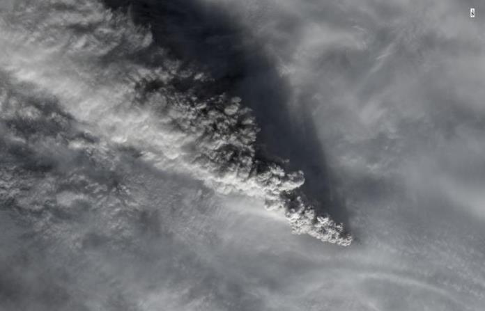
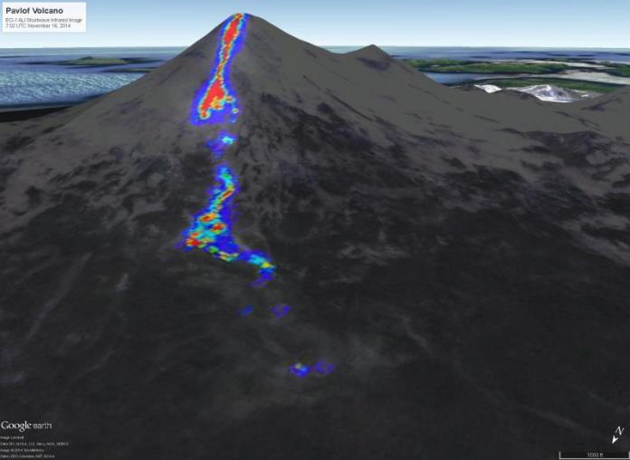
Landsat photo of Pavlof eruptive plume, Nov 15, 2014, photo courtesy AVO
Pavlof is the tallest of this group of volcanoes at some 2,500 m. Like the others, it is snow, ice and glacier coveed. Unlike the others, it has been very active with over 40 eruptions observed since 1790. This makes it one of the most active volcanoes in the Aleutians, perhaps in the entire state. The majority of the eruptions are Strombolian in nature with limited fountaining, lava flows down the flanks. The majority of the eruptive products are andesitic and basalt. Many of the eruptions of Pavlof are larger, explosive in nature, well into the VEI 2 – 3 range. The largest eruption of Pavlof was a VEI 3 in 1911. Given that the volcano supports an extensive snow and ice cover, lahars are common during eruptive episodes and have clogged most of the drainages that head off the volcano. http://www.avo.alaska.edu/volcanoes/volcinfo.php?volcname=Pavlof
As of 25 Nov 2014, the eruptive episode that began on 12 Nov 2014 had been officially pronounced over.

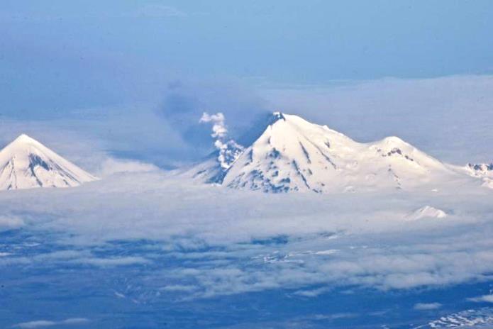
Pavlof in eruption, Pavlof Sister to the right, photo courtesy AVO, June 2014
Pavlof Sister is the farthest east volcano of the Emmons Lake Volcanic Complex. It is the only one that stands relatively alone. It is a single stratovolcano that tops out at some 2,140 m. Like the rest of the complex, it is mantled with snow, ice and glaciers. It is mostly andesite and basalt in construction with an extensive cover of tephra and pyroclastic deposits. There has been no observed activity on Pavlof Sister, though analysis of the deposits on its flanks indicate that it has operated much like Pavlof itself – mainly Strombolian type eruptions with occasional explosive blasts.
High temperature deposit on Pavlof following November 15, 2014 eruption, photo courtesy AVO, Nov 16, 2014
Finally, there are at least 12 large cinder cones present on the floor of the caldera complex. These are mostly scoria that is andesitic basalt in nature. The slopes and lava flows are steep and relatively fresh indicating they may be recent eruptions. Four of the cones have lava flows breaching the cones.
Conclusions
Given the relatively constant activity associated with Pavlof Volcano and the nearly complete filling of the last caldera with new stratovolcanoes, cones, vents, ash, lava and other eruptive products, I would suspect that the Emmons Lake Volcanic Complex is not finished with caldera-forming eruptions. It appears that the newer activity seems to be pushing a few kilometers east under Pavlof and Pavlof Sister. Watch this area closely, while it is not currently a very dangerous complex, given its history, things can get exciting in a very short time.
Lava flow down Pavlof, photo taken from Alaska Airlines 737, photo courtesy AVO, June 2014
Additional Reading
http://www.avo.alaska.edu/activity/Pavlof.php
http://www.avo.alaska.edu/volcanoes/volcinfo.php?volcname=Emmons%20Lake%20Volcanic%20Center
http://pubs.usgs.gov/sir/2006/5248/
http://www.volcano.si.edu/volcanoes/region11/alaska_p/pavlof/3805_Pavlof.pdf
http://cjes.geoscienceworld.org/content/40/7/925.full
http://www.ualberta.ca/~duane/Froese%20Dawson%20tephra.pdf
http://www.dggs.alaska.gov/pubs/id/27357
http://www.alpa.org/portals/alpa/volcanicash/11_alaskaplanvolcanicashepisodes.pdf


Just found this one an even more up to date Landsat on the Jardvis Facebook

I think the gradient ahead of the Northern flow steepens soon, which may make the flow accelerate and draw lava away from the south.
This is completely off-topic to volcanoes, but i feel the need to post this anyways.
Iceland have volcanoes that we all can enjoy, but we from the northern Norway, or more specific, we from the area around Tromsø where i live have another amazing thing we can explore. There is a reason why the area around Tromsø is so popular for tourists that want’s to explore the real nature of nothern lights.
The reason for it is because the northern lights here are simply stunning to watch. When you look up in the sky when the northern lights are strong and pretty visible, it’s like being in a new world.
So today, i found the best video of the northern lights from the area around Tromsø. It’s nothing more than stunning. Oh also, this video doesn’t contains any timelapses, it only contains real time video recordings in normal speed of the northern lights.
Enjoy this amazing video that simply gives me goosebumps all over my body :-): http://vimeo.com/113094940
Rescued by Spica
It’s like it’s taken from another time/space than this planet. And not even computer generated??
Nope, it’s completely real.
This was written in the description to the video: All sequences are realtime video, no timelapse used. This film shows the auroras how they really are in real world, not like in most timelapses where they flicker in ridicilous speeds over the screen.
So yeah 🙂
Agreed. I’ve shown this to my Wife. who has been to Norway, Iceland, and
the Yukon, but always in summer and she has never seen Aurora. She lived in Michigan which is as far north as NE Oregon, but has never seen Aurora like that. I’ve seen it exactly like that during very active storming, (45 deg., 20 Min North) bookmarked the Vimeo… I’d love to share the real thing with her…
Wow!
How wonderful! I’ve never seen any aurora – it must be stunning to see. Thank you for sharing. 🙂
I am so jealous! I would love to see this live. Thank you for sharing….just amazingly beautiful!
Amazing, particularly the sequence starting at 3:30. Just amazing.
Takk Tom-Helge. I first saw the Lights when I visited Tromsø a few years ago (apart from a possible sighting in Oslo back in 2000). It wasn’t the best display, but it gave me a taster. I have created a couple of timelapses from better sightings since then, both in Finland and Norway, but tried to keep them as slow as possible. More recently, I have thought about trying to get a movie at real speed, but you need a stronger display to be able to do it. When I was in Iceland a couple of weeks ago, it just went mad and it was the only time where they were moving as fast in real life as they often are in timelapses.My main camera was feeling the effects of Icelandic volcanic water, so I was using the other one, but a timelapse was impossible, as the shear speed just meant the images were solid green. Had my main camera been working, I would have attempted a video, but I doubt many would have believed it wasn’t a timelapse, had I been successful in capturing the Aurora in its full glory.
Oh wow! Thanks for sharing this Tom-Helge – it is truly superb.
Thanks Tom 🙂
Pretty amazing.
1) Booking ahead, gatwick (UK) to tromso about 200UKP.
2) How often would you see a reasonable display during winter?
3) How much does a hotel/house/whatever cost for a week in Tromso?
4) Presumably its often wet/cloudy/snowing there.
Hey.
1. The price looks reasonable.
2. I’m not the person who are much outside nowdays, so i’m not 100% sure. But after what the guy that made this video did said about the capturing of the auroras / northern lights, he had tons of it and is going to make more northern lights videos, so i’ll guess that the northern lights are visible quite alot when the skies are clear of clouds. But again, it’s all depends on how much counds there are.
But i would check that thing out on the internet though to be 100% sure.
3. Have you tried to chech out TripAdvisor or even Airbnb for that?
http://www.tripadvisor.com/Tourism-g190475-Tromso_Troms_Northern_Norway-Vacations.html
https://www.airbnb.no/s/Troms%C3%B8–Norge?source=bb
4. Sometimes it can be pretty wet and cloudy here, but we just recently got snow here in Tromsø which is a bit late compared to when we got snow some years ago. So the weather can change from year to year.
Chiles is really on a roll. I wonder if they will mention these tremors in their bulletin today.
Breaking news from Fogo: http://new.livestream.com/muzikatv/fogo

Today has been the worst day in the last ten days since the beginning of eruption in Chã das caldeiras. To the present moment, 57 houses have been destroyed, 51 cisterns and around 30 hectares of fertile land were consumed by the lava.
Tuesday, 1:10 PM – photo (and video) showing one school, a hotel and many houses engulfed by lava.
Eruptive activity seems to get more explosive in the last hours. Marc from vulkane.net visited the eruptive fissure and twittered 4 hours ago, that he can feel frequent earthquakes at Fogo. The volcano is in an explosive phase in the moment he said.
This reminds me of the great thing about Holuraun, we can enjoy it and no one is directly threatened (at the moment), so long as the wind is in the right direction.
Wow – so I just found a caldera in the Aleutians that dwarfs Emmons lake. Guess I have a good topic for a future post 🙂
Here a link to an article how they are using radar to follow the magma underground on the fogo eruption:
http://www.esa.int/Our_Activities/Observing_the_Earth/Copernicus/Sentinel-1/Fogo_volcano_on_Sentinel_s_radar
I think, and this is just my educated thought, that the eruption at Holuhraun will end in soon (by soon I mean 1 month or 2 months)
The high levels of So2 pollution have been absent since about 4 weeks, with no SO2 detectable anywhere across Iceland since a few weeks. This, together with an apparent reduced eruption rate as per the webcams, makes me think that we are watching the last stages of Holuhraun.
Question is how long will lava keeps this low level of eruption.
An alternate question, how long before anyone goes up and pokes it with a stick?
These people can probably help http://www.pokeastick.com/
Check out what is underneath Mt. Rainier in Washington State, US… https://agu.confex.com/agu/fm14/meetingapp.cgi#Paper/29046
Very impressive!
Indeed. Rainer has always been one of my favorite volcanoes.
Really impressive. But my money’s on Glacier Peak. that may hold a very nasty surprise. http://volcanoes.usgs.gov/volcanoes/glacier_peak/
Definitely interesting. Rainier is one of my favorite places on earth – it was probably one of the first places that kindled my love for volcanoes having been there when I was young.
With that said, I really hope it doesn’t erupt any time soon. I was thinking whether or not it would be a major catastrophe as the lahars there have the potential to. If it erupts and there are major lahars, it will be a disaster, but I feel like we’ll have enough forewarning of an impending eruption, that people can be prepared for potential lahars in the at-risk areas.
An old video. Categorize it as how not to watch a volcano. These people are lucky to have lived to tell the tale. When a dome/plug fractures/shatters, it isn’t usually sedate about it.
Good morning Lurking and everyone….. My reaction to this? There is a category of human beings I call a name that I am far too ladylike to type here. It is kept very firmly within the confines of my car and then only when on my own.
It is used when
1)
A perambulating body wanders in front of the car with no glance upwards or sideways. The body appears to be under the influence of some brain numbing substance or a mobile phone.
2)
A vehicle performs an illogical and illegal manoeuvre causing an observed near miss to another innocent road user or me to apply brakes to prevent impact.
3)
Most frightening of all a supposedly responsible adult drags small child/children/baby buggy between either stationary cars and trucks at traffic lights or makes a dash across the paths of moving vehicles to save seconds walking to a pedestrian crossing, thus ensuring the protection and safety of their young.
On a purely biological note, these humans theoretically should not live long enough to procreate. They however seem to be survivors and against all odds seem to be able to reproduce readily. Thus their offspring copy the adult behaviours with the result there is possibly now a sub species of Homo sapiens. These do not have super powers of survival,by way of super intelligence and honed skills but seem more like those animals that produce many offspring to naturally ensure one or two survive. However in our local habitat this sub species is protected and nurtured by ancient community behaviours which are exploited. These new behaviours are thus advantageous so that the accepted biological norm of the survival of the fittest appears not to apply.
🙂 Don’t get me started on the human race today… or people sending me unsolicited emails on Muslims and Christians, etc.
On Mila2 there is a shimmer of fire… a volcano fissure quietly doing its job and making me wonder about the magnificent universe we live in.
Reminds me of my cowboy/Indian (he was both) Pop on smarter than average cattle. “Sometimes I don’t know whether to breed’em or eat’em…
“or ” instead than “of “.
GL Edit: Done. Personally, I call the specialization that Diana refers to as “Homo Stultus”, or “stupid man”. Stultus has pretty much replaced the near extinct Sapiens as the dominant species on the Earth.
and not one hard hat between them….. Blessed, they were. Best!motsfo
Do any of the experts in here have any material on what an earthquake looks like on a borehole strain gauge when it is centered fairly close by to the gauge? I have long distance data, just lacking localised data. Thanks.
I’m sure you’ve seen this Scotsfjohn, it’s a link to the strain the last time Hekla erupted. Unfortunately the strain meters have been changed since then so it only gives a rough idea of what we can expect to see on the new ones. You’ll see that the first quake doesn’t show up on the strain other than to start to fall, the other quakes don’t really register either. Carl and Islander have said that an eruption (rather than a quake) at Hekla will be shown by a plummet (rather than a fall) on the strain meter.
Also, for those who have never seen a Hekla quake recorded, this shows how it is done on the Hekla graphs – as a line with a little square on top rather than the “N & E Velocity” which shows other ups and downs.
I know this is very old information but I hope it might help anyone who’s new to the Hekla strain graphs. 🙂
Thanks Talla, the reason I’m after it (as a Hekla nut) is to distinguish between the long range (ie BB) eq patterns and those closer hand since the long range are coming in as a single abrupt line across the actual uncorrected data stream. I was hoping to see more definition of P and S waves/ or not, just to see how they arrived at the strain meters and whether that suggested anything about the transfer of energy through the intermediate material.
Hmmm! I don’t think they’re set up to show that. The nearest thing I can find is the first image in this post about Hekla:
https://volcanocafe.wordpress.com/2013/04/19/dont-go-for-a-hike-up-hekla-irpsit/
This shows a 7+ mag quake from the Kuril Islands showing up on the strain and you can just see the P waves before the main S wave (at least I think that’s what it shows). When the line is less fuzzy it’s easier to see quakes coming in and I have seen definite P and S waves from very distant quakes – big ones in the Pacific for instance. But the local disturbances would mask that at the moment. I don’t have any expertise in this – just watch it a lot. I hope some more knowledgeable person can come to our aid. 🙂
I’ve been there, I can assure you Vaðalda is as cold as a well digger’s arse.
How many well digger’s arses did you touch to get a meaningful statistical sample. Also at any point in the process did you have to say “No I’m not pleased to see you, it’s just scientific rigor”?
Cheers Mike that increases the possibility I was seeing things 😉
Mike having fallen into a pit of Bentonite (driller’s mud) as a driller’s helper,
I second that ah, experience…
5C and raining that NE Oregon May morning..
Ahh Bentonite, great for providing a way to increase the mass/volume of drilling mud, and as a way of clarifying home-brew ciders and wines. Mix the food-grade Bentonite into the jug and let it settle out. Rack to down to a fresh bottle and presto, no lingering solids. 🙂
I use bentonite for re-lining canals and fixing leaks, no real desire to poke my arse in it.
A cold arse is about 30ºC (temperature of skin). So if Vaðalda is as warm as that, then it has similar temperature to a cooling lava field or some geothermal energy. Thus, my arse logic tells me Vaðalda is warm!
Obviously Mike was playing on the words, but he didn’t realize that a cold well digger’s arse is actually warm. But I know, Mike. The poor man cold arse. We are just having fun and joking. Like you said, Vaðalda is an extinct volcano, cold rock. I would say it’s also an eroded old shield volcano, but Mike could give its opinion on this one. Hopefully one day I am going to touch Vaðalda cold arse…
I came across this old video about Mt. St. Helen. I thought you all might enjoy it. Some incredible footage! It will also make you feel very old when you see and hear the film quality 😦 But the film of the eruption is amazing and quite scary….
That was really quite a day. I’ll never forget being overtaken by that enormous black ash cloud on that warm Sunday morning. It’s like it was just yesterday…
Thanks for posting the video.
It really was awful! So glad you got out of it ok 🙂
Ian, the paper below has a magnetic map covering a larger area around Iceland. It shows very nicely the spreading ridges n either side and the complex garble of Iceland. On Iceland the rift keeps jumping east and west so you don;t get the nice regular pattern. On this map you can see that the central area of Askja has low magentisation, as it should if there is magma above the Curie temperature. High magnetisation in some old lavas fields are due to (hold it) magnetite.
http://www.episodes.co.in/www/backissues/33igc/12-2new.pdf
Good morning Albert. I am afraid that link is broken. I tried opening all back issues shown on http://www.episodes.co.in but failed to find the map to which you are referring…my fault just scanning through too quickly probably. Which issuue is the paper in please?
Thanks Albert, the new link worked
That picture seems similar to the one I used to make the small map.
So the difference in magnetism could be a result of both age and when the lava was laid down? This would or could explain the buildup of higher magnetism surrounding the central volcanos either way. Makes it not such a good analytical tool.
xxxhttp://www.raunvis.hi.is/~geirf/seg/SVID.GIF
Does this work? There was an invisible non-ascii character at the end of the web address above. Put there by North Korea/China/US/scienctific publishers/google (replace with your favourite enemy). If this doesn’t work. ending the address with 33igc/ will give the full set of papers in that issue
Click to access 12-2new.pdf
I can’t select a favored enemy, my group of candidates are too stupid to have that skill-set.
Interesting article on Laguna del Maule volvanic region in Chile, building up to a large eruption.
http://www.ibtimes.co.uk/chile-mega-volcano-field-could-trigger-eruption-100-times-larger-mt-st-helens-1477693
Interesting – been a while since we’ve heard anything on Laguna Del Maule. With that said, from what we know of large volcanoes, there can be a considerable volume of uplift before we see an eruption. 70 centimeters of uplift in 7 years represents a lot of magma, but compare that to the meters of uplift in Campi Flegrei or the insane uplift at Ioto, and this just isn’t much (comparatively speaking). That doesn’t mean an eruption can’t happen, but it isn’t conclusive in any given way from what we know.
Has Chiles volcano, Are the earthquakes, magma etc. Are long period events occuring.
Brain isn’t completely in the zone so to speak. What I want to know is how the speed of the intensying tremor.
The view at Mila 2 isn’t top clear but fair.
Thanks Rob. Mila 1 seems to be iced up with spindrift ( wind blown snow); I wonder why Mila 2 is clear?
Can’t think of anything …
❓
New Post is up, on Fogo! 🙂
https://volcanocafe.wordpress.com/2014/12/03/how-strangely-fogo-burns-amidst-an-ocean-full-of-flying-fishes/