Some links to monitor our Bob & his mysterious-though-as-yet-hidden friends at El Hierro:
- IGN El Hierro page with earthquakes, tremor plot, daily updates, etc.
- Two days of tremor plots by IGN for all Canary islands
- Map of IGN stations on El Hierro
- GPS deformation from IGN via AVCAN and Prof Takeshi Sagiya at Nagoya University, Japan, IGN google map
- AVCAN page and facebook forum
- INVOLCAN on facebook
- Spanish Oceanographic Insitute reports on the scientific campain of Ramon Margalef at El Hierro
- Localiza todo – ship finder to spot the sometimes elusive Ramon Margalef
- Daily MODIS Aqua/Terra photos of Canary Islands from NASA
- MERIS/ASAR imagery from ESA Envisat – search geographically to find radar images of Canary islands
- Real-time weather satellite images of Canary islands
- Weather observations – hourly readings for El Hierro Aeropuerto
- Water and air analysis reports (Spanish)
- IGN official petrological analysis of restingolitas (Spanish)
- Classification of IGN’s samples (by Lurking)
- Another Page about GPS variations by IGN.
- Accumulated energy IGN
- Air Quality AVCAN New
- Air quality in La Restigna at the very moment.
- Exel List of the Quakes for the plotters. New
- Cabildo El Hierro youtube channel
- Información y comunicados a la población del área de Seguridad y Emergencias del Gobierno de Canarias on Twitter
- RSS feed El Hierro and su tarnsformation
- RTV Canarias (thx Jenny for the link): direct TV streaming or written news
- La Provincia – newspaper of the Canary Islands
- Canarias7 – digital newspaper of the Canary Islands
- La Opinion – another Canary Islands newspaper
- Diario El Hierro – digital newspaper of El Hierro
- El Hierro digital – another digital newspaper of El Hierro
- El Pais – Spanish newspaper, national edition
- A blog by Spanish volcanologist Jose Luis Barrera Morate
- Canary GPS data
- Geological Map of El Hierro
Info about Canary islands:
- Detailed map of Canary Islands – use Busquedas to find a particular place or check the 3D lidar model
- IGN variation of Google maps – Iberpix
- Geological map of El Hierro
- Volcanic history of Canary islands
- El Hierro – videos from the air
- Aerial photos of Canary islands
- Beautiful photos of El Hierro
Webcams:
-
- La Frontera webcam
- Hotel Ida Ines webcam
- Webcam Cabildo El Hierro
- Meteo las Puntas
- Mirrored Webcam Las Puntas
- Panoramic view on El Hierro from La Palma
most cams do not work anymore, i leave the lnks so… in case they might return one day.
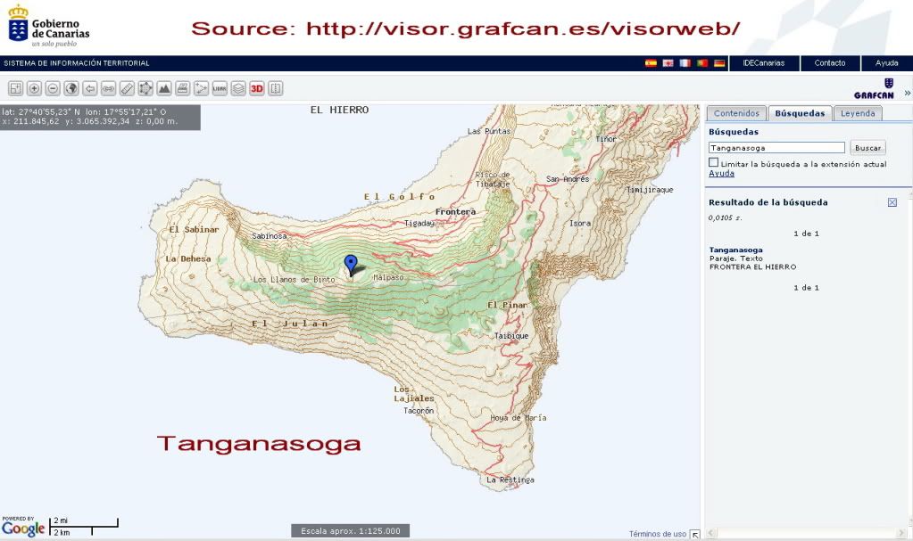
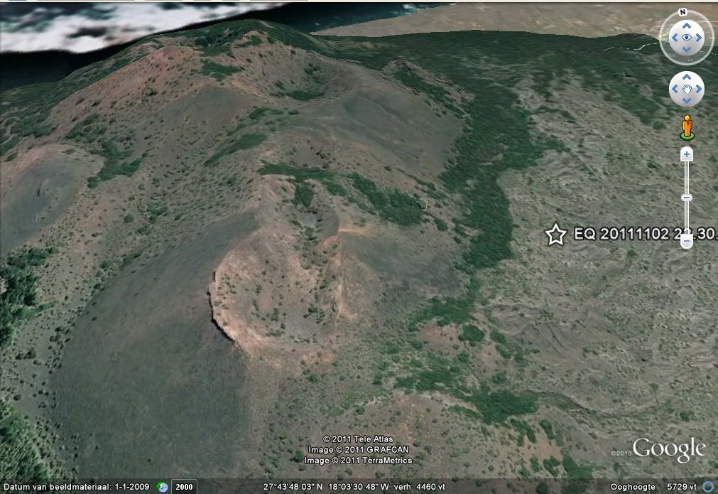
Tanganasoga related info:
- Location on map and Google Earth picture (by Sissel)
- Longpre et al. 2009, Ankaramitic Lavas and Clinopyroxene Megacrysts From the Tanganasoga Volcano, El Hierro Island (Canary Archipelago), AGU 2009
Chemical composition
Floating stones off El Hierro, Canary Islands: xenoliths of pre-island sedimentary origin in the early products of the October 2011 eruption. Published on solid earth net.
An eclectic collection of scientific papers related to El Hierro, as suggested by readers . Please, suggest some more:
- For those who are interested in the slides of El Hierro, a must read:
Urgeles et al. 1996, The submarine El Golfo debris avalanche and the Canary debris flow, West Hierro Island: The last major slides in the Canary archipelago, Geogaceta, 20(2), 390-393. - Hierro and other Canary islands erupted through an old layer of sedimentary rock: Schminke and Sumita, 1998, Volcanic evolution of Gran Canaria reconstructed from apron sediments: synthesis of VICAP project drilling.
- Why El Hierro may have severe problems with plant growth, an analogue description from another volcano: USGS, Invisible CO2 Gas Killing Trees at Mammoth Mountain, California
- Carracedo 1999, Growth, structure, instability and collapse of Canarian volcanoes
and comparisons with Hawaiian volcanoes, Journal of Volcanology and Geothermal Research, 94, 1–19. - Masson et al. 2002, Slope failures on the flanks of the western Canary Islands, Earth Science Reviews, 57, 1–35.
- Muenn et al. 2006, Gravitational spreading controls rift zones and flank instability on El Hierro, Canary Islands, Geol Mag, 2006, 1-12.
- O’Hara 1997, Volcanic Plumbing and the Space Problem—Thermal and Geochemical Consequences of Large-Scale Assimilation in Ocean Island Development, Journal of Petrology, 39(5), 1077-1089.
- Stroncik et al. 2009, The magmatic plumbing system beneath El Hierro (Canary
Islands): constraints from phenocrysts and naturally quenched
basaltic glasses in submarine rocks, Contrib Mineral Petrol, 157, 593–607. - Sagiya et al. 2009, Continuous GPS observation in the Canary Islands for Volcano Monitoring.
- Vinuela JM 2007,The Canary Islands Hotspot (pdf)
- Carracedo et al. 2001, Geology and Volcanology of La Palma and El Hierro, Western Canaries, Estudios Geologicos, 57, 175-273 (large pdf file, 12M)
- Martin and Sigmarsson, 2005, Implication for the origin of tholeiitic silicic magmas from atmospheric pressure fractional crystallization of basaltic lava flows on Reykjanes peninsula (Iceland), Lanzarote (Canary Islands) and Masaya (Nicaragua), EGU 2005.
- Neumann et al. 1998, Evidence for Fractional Crystallization of Periodically Refilled Magma Chambers in Tenerife, Canary Islands, Journal of Petrology, 40(7), 1089-1123.
- Causes and mechanisms of the 2011–2012 El Hierro (Canary Islands)
Islands) submarine eruptionJoan Martí,1 Virginie Pinel,2 Carmen López,3 Adelina Geyer,1 Rafael Abella,3 Marta Tárraga,1 María José Blanco,4 Antonio Castro,5 and Carmen Rodríguez5
More links to come…
Links contributed by: Carl Le Strange, Peter Cobbold, Lurking, Diana Barnes, georgiade, Alan_C, mirri, Bruce Stout, Una Canaria, Tim_AJ, Toni Kay Ryan, Jenny, Robert Sommerville, Sissel, Hattie, Fanfoe63…
Enjoy, Ursula ( and Spica)

This is a link to the national Radio & TV for the Canarias. Handy for those who speak spanish and would rather listen that have to read first think in the morning to find out whats happening.
http://www.rtvc.es/television/enDirecto.aspx?canal=tv
This is a link to the Water and Air analysis reports
http://www2.gobiernodecanarias.org/sanidad/scs/contenidoGenerico.jsp?idDocument=a160983d-062e-11e1-9caf-63b12166421c&idCarpeta=0428f5bb-8968-11dd-b7e9-158e12a49309
Feel free to include or bin as you wish!
And here is the much sought after location-map of the stations in El Hierro:

@ Carl
Haven’t forgotten the booklist – just got to find some of them!!
@ All
The books I’ll list date from my college days, so most are quite old but can be obtained 2nd hand etc from such as Abe Books
http://www.abebooks.com/books/Textbooks/
I’ll also attempt a ‘basic/intermediate/advanced’ categorisation to guide!!!
re new detailed ElHierro GPS plots:
found them here :
http://www.avcan.org/?m=Gps
This link should work for the Stroncik paper:
Click to access fulltext.pdf
great idea Carl!!
Nice page about the volcanic history of the Canary Islands (text is in spanish, but there are loads of photos and videos):
http://miguelbravo.com/VARIOSTEMAS/volcanes%20canarias/canariasvolcanes.htm
Here’s one I found through a post on the AVCAN site. There is a newish (3 posts so far) blog in Spanish covering the Volcanic Crisis of El Hierro written by José Luis Barrera Morate, a geologist specializing in volcanology. Maybe he would write something here.
http://blogs.elcorreogallego.es/elhierro/
Hattie just contributed this little gem on the other thread:
http://adsabs.harvard.edu/abs/2009AGUFM.V51A1662L
looks like you don’t have this link – second half is all el hierro
Click to access volcan2.pdf
good combined webcam mirror with 4 webcams
Sondebueu says:
November 30, 2011 at 10:20
http://www.elhierrowebcam.com/
you can save images…

And post live ones:
If dont see, press F5 to refresh.
(sure any can save it each any seconds and create a timelapse..)
details on various gas levels which can exported as csv or excel
http://www.gobiernodecanarias.org/cmayot/calidadaire/datosOnLineEstacion.do?ides=124
I haven’t managed to find hourly air quality data as posted by Armand Vervaeck in that link.
Sorry, wrong post. Please delete.
A SHIP! A SHIP!! HELP!! HELP!! OVER HERE!!!!
helicopter ?
Wow! This can be one particular of the most helpful blogs We’ve ever arrive across on this subject. Basically Fantastic. I’m also a specialist in this topic so I can understand your effort.
http://elhierroysutransformacion.blogspot.com/ This is a great link!
This Bob webcam “always” works and does not show ads!
All webcams!
Wow! Thank you Ursula – and all xxx
Access of seismic and spectral charts of IGN El Hierro seismic stations:
No direct links have been found yet, but the information can be obtained starting at the IGN page http://www.01.ign.es/ign/resources/volcanologia/HIERRO.html
Click the link “Forma de onda CHIE” and you get the seismic chart of CHIE station with the URL http://www.ign.es/ign/head/volcaSenalesAnterioresDia.do?nombreFichero=CHIE_2012-07-08&ver=s&estacion=CHIE&Anio=2012&Mes=07&Dia=08&tipo=1
By manually changing this URL you can access the other stations.
Replacing CHIE with Corc (twice!) gives the URL leading to CORC station (Orchilla).
NB all names are case sensitive!
CORC – Corc
CTAB – Ctab
CJUL – Cjul
CTAN – Ctan
CCUM – Ccum
CMCL – Cmcl
CRST – Crst
CTIG – Ctig
Changing tipo=1 into tipo=2 gives the URL to the associated spectral chart.
Changing the date (twice!) in the URL leads you to older data.
Map with the locations of the IGN stations (green spots):

(This is the map you get when clicking the Info link [+] in the list of recent quakes.)
Pingback: El Hierros´western part on “Code Yellow”. | volcanocafe
Pingback: Schunday Schummary: El Hierro. | VolcanoCafe