How rifting occurs in Iceland:
Iceland sits in the rifting area between two tectonic plates.
The North American and European drift apart in opposite directions. One towards east-southeast, the other towards west-northwest.
However the rifting is not homogeneous. It occurs differently in different sections of the rift area.
Please have a look at the following picture:
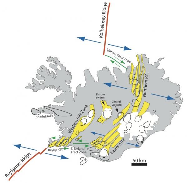
Over the area between Hekla, Katla and Vatnajokull, the rifting occurs almost perfectly at angle perpendicular to the direction of the plate movement. The rifting opens aligning volcanic fissures from the NE to SW, while plates drift towards the NW and SE respectively. This means the earth rips easily open in those regions and this allows for large volumes of magma to erupt. Of course, earthquakes do happen in these regions, and they happen constantly (nearly every day – more than in any other region of Iceland) and therefore they are mostly small sized earthquakes. These are the daily earthquakes at Katla, Vatnajokull and Askja.
However in two sections of Iceland, the southwest seismic zones, and in the north, in Tjornes seismic zone, the plates move apart each other in a almost sideway motion. This creates notorious strain in the rocks, and creates much larger earthquakes. These are called transform seismic zones; regions where motion is sideways.
Daily, they are only very tiny earthquakes, but occasionally, every few decades, strain accumulates and then these areas experience large 6.5 earthquakes. Once they come, they occur in clusters, with every few years a larger earthquake (just like the south Iceland earthquakes of 2000 and 2008), and then reverting to calm decades again.
Moreover, these two regions, experience mostly their plate movement through large earthquakes and do not allow much for volcanic eruptions. Yes, they do occur, but more rarely and smaller. Volcanic eruptions have known to occur in Tjornes and SISZ, but last one in the SISZ was 3000 years ago, in the Grimsnes volcanic system, and it was very small.
It has been confirmed that every major tectonic episode is joined by magmatic intrusions at deep, but rarely they come near the surface. To understand why, just imagine the two plates drifting side by side; this does not create much fracture space in the rocks to allow magma to move upwards, magma would move easily laterally than upwards. However, in the rifting regions near Vatnajokull, like the dead zone, rifting is perfect, and when the crust rips open, large volumes can move upwards!
In other regions of Iceland, rifting occurs at different angles, like Reykjanes, where plates create a rift area about 45º angle from the plate movement. Like results it seems in a “middle ground way” between the two former situations. Eruptions are mostly medium size and occasionally large but rather rare, and strain does accumulate and is released in larger earthquakes, but not as large as the two transform zones of Iceland (mostly up to 5.5).
Furthermore, it seems that rifting activity in the north has been occurring in recent decades. In 1975 Krafla began several episodes of fissure rifting eruptions. This lasted until 1984. Also further north, in Tjornes, there was a large and damaging earthquake (almost up to M7) in 1976. Probably this was a consequence of the rifting process extending further north. So, now it is mostly natural that we are experience another series of major rifting episodes, mostly tectonic, even further north.
Recently, also another volcano has shown signs of uplift and more earthquakes, the Theistareykjarbunga volcano. While still unlikely to erupt, this shows how activity in the rifting regions seems to propagate further north or south over the decades, as strain is released and triggers other nearby regions.
I could almost say that the whole of this could have started back in 1874, when there was a very large rifting episode in Askja, which extended further northwards, and culminated in an eruption very large in 1875.
In Tjornes, there is still the potential for a large earthquake, up to 6.8.
Likewise, we have been experiencing what seems in recent decades an increase of rifting activity in south Iceland. Hekla has been erupting regularly, the Westman islands erupted in recent decades, and Eyjafjallajokull also, as well as two large earthquakes in the south seismic zone. It is natural to expect further movements in neighboring seismic fractures and volcanoes in south Iceland.
Irpsit
———————————————————————————————–
The north of Iceland saw more than 400 quakes today. GFZ lists the strongest one as a 5.3, IMO has it as 5.4. But more than 400 quakes shook the Tjörnes fracture zone today.
Chryphia did an image and explains it:
The Tjörnes fracture zone is really busy again! This is how it looks in respect to all earthquakes from 2011:

The red dots represent (from North to South) Kolbeinsey Ridge, TFZ submarine volcano and Theistareykjarbunga. The current swarm is nicely blending in previous swarms from the past years. They are all very much contorted.
The data are from http://hraun.vedur.is/ja/viku/2013/vika_14/listi and apparently only the earthquakes at 99% find entry there. That´s why herehttp://en.vedur.is/earthquakes-and-volcanism/earthquakes/tjornes-small/#view=map they seem to be distributed widely, all qualities are included, when revised they will become more “concentrated” I guess.


This was to been seen on http://en.vedur.is/earthquakes-and-volcanism/earthquakes/tjornes-small/ this evening.
Chryphia: This 3D video shows the recent swarm in the Tjörnes Fracture zone, but only 99% earthquakes until 7:07 this morning. In the close-up view you can see how twisted (the angle Irpsit was talking about?) the fault zone is and that commonly the swarms happen along a narrow streak.
While i am publishing this post, the swarm is still ongoing.
So for our newbies 😉 some links to watch:
http://en.vedur.is/earthquakes-and-volcanism/earthquakes/
http://en.vedur.is/earthquakes-and-volcanism/earthquakes/tjornes-large/
http://en.vedur.is/earthquakes-and-volcanism/earthquakes/tjornes-small/
Thank you Irpsit for this comment. Used in a post at your request!
Spica
Update: The trend of the quakes is slowly moving to the southeast.

There have no been a little under 700 quakes 75 of them over Mag. 3.
http://www.vedur.is/skjalftar-og-eldgos/jardskjalftar#view=table
And of course neither Irpsit nor chryphia nor me are experts, just interested amateurs.
Spica


Thanks Irpsit, Spica and Chryphia …. great stuff as always!
Yes, its not bad. But there should be sources indicated for your text, Irpsit. (books, science articles etc.)
And also – a disclaimer, in case you are not a geologist.
Yes I agree Inge. I remember most stuff by memory. It will take me a while to discover the papers where I found these facts. I had several of them in my old laptop which is now dead.
But Global Volcanism Program is a good source for eruption history.
For the rift/hotspot theories, please read:
http://www.dur.ac.uk/g.r.foulger/Offprints/FoulgerJVGR1.pdf
http://www.mantleplumes.org/WebDocuments/hotspot_saga_fin.pdf
I cannot find the paper where they talked about the hotspot plume spreading northwards and southwestwards. It is such a favourite of mine but I can’t find the paper right now.
You can find some papers on teh rift orientation. For example, here they talked about the 56º angle in Reykjanes rift.
https://www.google.is/url?sa=t&rct=j&q=&esrc=s&source=web&cd=1&cad=rja&sqi=2&ved=0CCkQFjAA&url=http%3A%2F%2Fjardvis.hi.is%2Fsites%2Fjardvis.hi.is%2Ffiles%2FPdf_skjol%2FJokull58_pdf%2Fjokull58-einarsson.pdf&ei=hiJcUa3QOcutPI2YgOAB&usg=AFQjCNGfiq02gkOPBgc-5p-9yqEpStyP9Q
Also another favourite paper of mine is the one where they measured the rifting in cms in the several eruptions of the dead zone, and they also explain the dynamics of those dead zone eruptions. Can’t find that at the moment. Maybe someone knows this one.
Maybe I can take some time collecting these references and then Spica can edit them into the text.
http://www.annualreviews.org/doi/pdf/10.1146/annurev.earth.28.1.107
Another nice read.
Wonderful article, thank you. A little bit OT – I wouldn’t want to be in the vicinity when an Icelandic volcano starts chucking rocks:……
http://www.telegraph.co.uk/earth/earthpicturegalleries/8162754/Eyjafjallajokull-Volcano-in-Iceland-a-book-of-photographs-by-Ragnar-Th.-Sigurdsson.html?image=7
This one was transported by …. water. Likely jökulhlaup (flash flood) or from eruption or left behind by the Glacier. This photographer took many good pictures, but there were some good photo days I think he missed 🙂
Ah….thank you. But ye gods, transportation by water seems even more incredible than being tossed out by a volcano!
Inge preparing yours now, but i had to react to the swarm today.
You can also wait some days, perhaps better to follow the swarm still a bit.
So there are also Hekla and Grímsfjall … 🙂
Thank you to Spica for preparing this post . I am sure Irpsit’s and Chryphia’s comments will be useful for many visiting here and will put the present activity into perspective.
Chryphia, I do hope your son is feeling better after suffering Post Easter Bunny Syndrome 😀
I have also just commented on a wonderful photo of Hekla that Islander included in his last comment on the previous post. It’s well worth going back to look at to give a new perspective of that monsterous mountain.
Diana, my son is feeling better now, he even requested lemon juice filled into his hot-water bottle 😉
This is a good sign. 🙂
M3.7, 10 min ago http://www.emsc-csem.org/Earthquake/earthquake.php?id=310927
RÚV cites Icelandic scientists saying there could be more and even bigger earthquakes possible, because of stress changes within the crust after the big quake this morning. The quakes could also be infect other faults in the vicinity in the NW or SE. http://www.ruv.is/frett/fleiri-skjalftar-gaetu-ordid-naerri-grimsey and http://www.vedur.is/um-vi/frettir/nr/2680 . The Uncertainty alert level is now valid for the north of Iceland, and people are asked to read the information on earthquake preparedness. http://www.ruv.is/frett/folk-skodi-leidbeiningar-vegna-ovissustigs
There are also interviews by Rúv in the news with people from Grímsey and the geologist Páll Einarsson (in Icelandic): http://www.ruv.is/sarpurinn/flokkar/frettir (around 29:00).
Thank you Irpsit, Chryphia and Spica. Interesting read 🙂
Just found an article that will be of interest to all on Science Daily at http://www.sciencedaily.com/releases/2013/04/130402124537.htm . Drs Jacqui Owen and Hugh Tuffen (Lancaster University) and Dave McGarvie (The Open University) have been looking at ashes from Torfajökull and found evidence for the potential for high explosivity due to higher gas and water content than previously understood.
OOPS meant also to say thanks for the fascinating article!
Thank you for the link, Clive.
Most of Icelandic eruptions have been producing basalt, but it has been known now for some time that rhyolite is found in most of the central volcanoes. But these scientists have thoroughly researched the details on this.
H. Tuffen and D. McGarvie have been doing research in Iceland rather often and H. Tuffen has also lately researched the only other rhyolitic eruption to have been scientifically covered in action up to now in the world which was Puehuye-Cordon Caulle (after Chaitén in 2008). See also Tuffen’s expedition photos: http://www.flickr.com/photos/27337835@N00/sets/72157632557249894/
And Dave McGarvie wrote a post on Torfajökull on his own blog: http://davemcgarvie.wordpress.com/2012/05/18/torfajokull-waiting-in-the-shadows-7/
(I also liked a lot his blog post on Katla, one of the best posts on volcanoes ever!)
Thanks for the links!
Kind of intriguing. Fractionation is one thing (explains the rhyolite) but where are the volatiles coming from? Old plate fragments? Would they still contain enough water to do the job? Sounds improbable to me as most water gets driven off by 100 km depth and as far as I understood it, the old plate fragments are deeper. Maybe Carl was right with his hidden subduction scenario thesis, although I think he only posited this for Hekla.
Hi, good morning all! 🙂
The rhyolites are all over Iceland, you even find them in Tertiary volcanoes in the West Fjords, there can’t be subduction zones all over the place, even if there would be some subduction near Hekla.
But perhaps there is something in this theory about old plate fragments.
Would be nice, to find answers to your interesting questions. 🙂
In this article’s abstract (paywalled) http://link.springer.com/article/10.1007/BF00302832#page-1 , there is explained that at Karfla the rhyolites formed by fractional crystallisation at the margins of magma chambers.
This one could also be interesting, though an older one, also abstract/paywalled: http://link.springer.com/article/10.1007/BF01829378#page-1 B.D.Marsh, etal.: Hawaiian basalt and Icelandic rhyolite: indicators of differentiation and partial melting. (1991)
The authors of the last paper mention that about 10-12% of the rocks in Iceland are rhyolites which will be found at central volcanoes in the form of intrusions and in the vicinity of other rock forms like granite or basalt.
Ignimbrite sheets are seldom to be found (so the authors), I know one though at Skardsheidi in the west of Iceland, and I know a lot of rhyolitic lava domes eg. in Torfajökull area or also some here and there in the country like Maelifell on Snaefellsnes.
There’s also the Thorsmörk ignimbrite from Tindfjalla. Heidi Ritterbusch sent some of us her thesis on it.
A bit of scientific literature by the a.m. authors re. Torfajökull:
http://eprints.lancs.ac.uk/18/2/Microsoft_Word_-_Tuffen_et_al_2001.pdf and http://www.es.lancs.ac.uk/vgrg/People/hugh/pdfs/Tuffen%20BV%202007.pdf
M3.4, 12Km… this is more intense again?
Yes, it seems to intensify a bit now: http://en.vedur.is/earthquakes-and-volcanism/earthquakes/tjornes-large/#view=table 5 quakes over 3 in 20 minutes.
This is something for GeoLurking: http://www.vedur.is/um-vi/frettir/bigimg/2680?ListID=0
IMO scientists explain the direction of failure during the last big quakes.
http://www.vedur.is/um-vi/frettir/nr/2680 The magn. 5,5 was a strike-slip quake on a NS strike slip fault, the 4,7 a normal fault rupture.
The Krafla tremor graph has been clipping with the quakes and is out of order now: http://hraun.vedur.is/ja/oroi/kvo.gif
This is also interesting as there has been uplift lately in the northeastern part of Krafla fissure swarm. http://strokkur.raunvis.hi.is/gps/KRAC_rap.png
Interesting, appears the quakes are still migrating south.
Surprisingly few in the rest of Iceland; or hasn’t IMO updated the maps for these?
http://en.vedur.is/earthquakes-and-volcanism/earthquakes/tjornes-small/
yes, they are migrating slowly south-east, but at present I think there is no way of telling how far, or how serious this can become. So far there is Uncertainty Fase in effect.
Four (4) quakes of over 4R in the past two hours, and some charts I see, but can not post, indicate to me swarm is heavier tonight than earlier today. The swarm (probably can be classed a major event by now) is continiuing. This was suspected according to RUV news tonight, interview with the expert on duty at IMO, and can go on for days or even weeks. My view *not expert* is that they can progess towards the coast at Húsavík or Kópasker towns. People there probably are well prepared, I hope so.
That is interesting. Sort of like a segment was pulled to the SE and detached from the northwest end.
Icelandic news flash about change in location of the quakes, further away from Grimsey Island http://www.mbl.is/frettir/innlent/2013/04/03/ny_throun_i_skjalftavirkninni/
Iceland is a country that’s going places; that was a useful post, and this is a useful index:
http://gps.vedur.is/index.php?p=ts
I’ve not seen that before -looks a more user friendly access to GPS data.
-the interactive map for the stations is a vast improvement, it expands! No need for high precision on the glide pad.
Gott kvöld. That article was great. Allways interesting to learn more about the activities on and beneat Iceland.
It is fun that we can learn much more about quakes and volcanoes there than it we did at school when we was young (At least I have, and still will do thanks to this amazing blog 🙂
I tried to count the numbers of green stars, but gave up 🙂 I guess it’s more than 20.
Hello. Green stars: Presently at 62 (00:29 hrs) and changine every hour. Green star is for quake larger than 3. Here is the present list. You can have it open in a tab, and refresh now an then and notice is there are sinificant changes in numbers, list is for preeceeding 48 hours (please bear in mind this creates server load, which we avoid on purpose in time of emergencys, so IMO system can better do its work)
http://en.vedur.is/earthquakes-and-volcanism/earthquakes/#view=table
I find it interesting how the depths of the quakes varies wildly.
Possibly due to the numbers on them, the auto-function perhaps is not good at that ?
http://en.vedur.is/earthquakes-and-volcanism/earthquakes/#view=table
Some of those depths depend on phase picks. if the pick gets moved, the calculated depth can change. Once they get to analyze a lot of seismos, they can work it through the crust model to get a better estimate.
And just in case ‘yall get complacent while thinking about the two plates and how they move where the MAR cuts through Iceland…. Don’t forget the two guys on surfboards wedged in between.
Hreppar and Tröllaskagi microplates:
http://my.opera.com/nielsol/blog/show.dml/10513421
this SIL plot Melhnausar (from near Mývatn Lake) shows well the intesity of the tonights activity, and can go on for several more days http://hraun.vedur.is/ja/oroi/mel.gif
and quakes hit 600 mark
That i never saw: 48 hours without earthquake on http://en.vedur.is/earthquakes-and-volcanism/earthquakes/myrdalsjokull/
I belive this possibly be false, the “noise” from the swarm in the north simply drowns the few and small quakes in Katla, but true: posibly very few and very small 🙂
Yes, central Iceland is a sink-hole (pile) and comes up now and then via Hekla Volcano, and, yes I had seen this. I think this swarm today(s) is MAR related, last big episodes approx. 40 years ago (the 7+ R event in 1960´s), so this was the expected they thought was coming earlier this winter. As this is writtem, some slacking seemed in the swarm, but it apparently picked up again.
reply to Lurking above, that’s interesting.. this is another example of plate boundaries suddenly taking a step to the right instead of progressing in steady motion. The same thing has happened in New Zealand / Havre Trough / Kermadec Trench. It’s as though the plate boundary suddenly gets stuck and starts somewhere else because its easier.
Modelling strike-slip faults in a sandbox shows formation of steps:
Drifting southeast now… and one slap in the middle of Theistareykjabunga, unless it’s a ghost…
hi Mike, good catch on the incandescene at White Island. I have been keeping an eye out for the onset of Strombolian activity but hadn’t seen anything. It seems like it’s there, just very very small.
Just when I was thinking El Hierro was going back to sleep it goes and has a 4.4 quake.
1203736 03/04/2013 02:45:26 27.7355 -18.2838 19 Sentido 4.4 mbLg W FRONTERA.IHI
And now a 4.2 also.
1203773 03/04/2013 03:41:26 27.7335 -18.2939 19 Sentido 4.2 mbLg W FRONTERA.IH
looks like it, having a rest and of she goes, most likely envy with all the attention on Iceland
Hi
Well it is always difficult to make a guess, but it makes for quite a different episode than in 2011….I’m getting more and more concerned for the population of El Hierro
Besides those earthquakes today there seems to have been an increase in the tremor signal over the past 12 hours. It is a little windy so it could possibly be weather related but it seems to have crept up during the night
BTW, re Iceland, isn’t it great to see a large igneous province form before our eyes!
And does anyone see any dinosaurs dying?
(just a thought-for-the-day)
Despite my sometimes flippant comments, deep down I am always excited and awed by the fact I am watching those somewhat dry Geology facts learned at school that seemed something related to Dinosaurs and Eohippus and almost as extinct, happening, moving, and unfolding here in my little Office at home. If someone had told me 60 years ago as I sat watching the Young Queen Elizabeth’s coronation on this wonderful thing called television , that I would be able to press a button and see live pictures from Iceland I don’t think I would have believed it. My lifetime has seen amazing technology developments. Science fiction becoming fact! I am glad I can appreciate all this rather than take it all for granted.
Time for Coffee #2 before I get any more maudlin!
With you on the amazement front Diana. One of my more fulfilling moments was waking one morning and finally seeing the eruption cloud from Eyjafjallajökull jetting straight up 3000 meters before billowing away to the east in the early morning light after days of bad weather and no sightings and sitting there at home watching this awesome spectacle after weeks of deliberation and quizzing over it all.
For the people living under the volcano it was not a spectacle. People feared for their crops, their animals and their children. Didn’t even want their children to come home from boarding school for the weekend. Little children weren not allowed to play outside in the surrounding villages so as not to inhale too much ash (their noses nearer to the earth).
.. well, um, yeah. What can I say?
” If you cant stand the heat get out of the kitchen” seems apt.
This is not so easy, most of the people living near the Eyjafjallajökull (and Grímsvötn, also Hekla etc. ) area are farmers. This is their living. And their families have been living there for ages.
Let alone all the people living near volcanoes in developping countries, who are too poor and uneducated to have any choices!
Then again, no volcanos, no Iceland. 😉
Speaking of which, Etna’s looking pretty good at the mo.
Same with me: one moment I will never forget in my life! I was entirely unsuspecting, looking for some information on Fimmförduhals, and came across a webcam that was set up for it. At that time I barely knew what a webcam was, let alone a volcano, and the name Eyjafjallajökull wasn’t in the news yet. Looking over a high snowy plain, and behind it a small black thing rose… and rose… and got big… and bigger… until weather clouds covered the view. It took several hours before the first reports about Eyjafjallajökull erupting appeared. That must have been the first explosion, and I was almost scared watching it, not knowing what it was.
Watching it in “real life” was awesome. The cloud cover slowly giving way to sunshine and exposing the ash coloum that previously had been hidden. Copyright lies with the photographer. http://i46.tinypic.com/10z77kh.jpg
Reptile Dysfunction… never a pretty site.
Like Custer, the Geko has it coming.
Good morning all. I have been reading this paper produced by the Iceland Met Office Development and Implementation of Seismic Early Warning Processes in South-West Iceland
I highlights how relatively new the SIL stations are that we now take for granted and also gives an insight into the work behind those red dots!! This paper and others worth reading can be found here. http://en.vedur.is/earthquakes-and-volcanism/reports-and-publications/
II am pretty sure the rattling that is happening up North will mask the quakes under Myrdalsjokull and elsewhere unless they are very large. The migration of quakes towards the South east is interesting. I wonder if it will prod Theyr….Thei….Theistareykjarbunga awake. Oh how I would love to see how the News media cope with that name. 😀
,
media shurely will make a mess of … Bob 🙂
🙂
I was wondering about the strong contortion of the eq swarms in that region and found this: Décollement, or basal detachment fault. They can occur both in extensional and compressional settings.
Rock bodies with differing lithologies have different characteristics of tectonic deformation. They can behave in a brittle manner above the décollement surface, with intense ductile deformation below the décollement surface.
http://en.wikipedia.org/wiki/D%C3%A9collement
Morning
This is the El Hierro earthquake animation update up to April 2nd 23h57.
We still see no extension of the main swarm. There seems still be a sort of “reflux” to the previously active zones (Is this to be linked to the GPS graphs where the island upward deformation seems to lessen ?).
An original triplet of quakes under the center of the island on April 1st around 9h and one quake under the Ocrhilla zone very late on the 2nd.
The data has been “trimmed”, which mean that the quakes with the higher error margin have been removed from the list. also the quakes are shown only for April 1st and second. All the older quakes since March 18th are small black dots. All the remaining quakes (up to July 2011) are in small cyan dots.
Color of the circles is proportional to their position in the list. (see left of colorbar).
Right scale of colorbar is related to terrain elevation.
Size of the event is shown in the diameter of the circle.
The “current” event is shown in red with a multiplicating factor of 8.
The bathymetry is also shown.
The video is divided in 4 parts. First an event by event timelapse, then a rotational phase followed by a 0-90 ° rotation to show a top view of the swarm. Finally a zoom is made focused on the last event.
Data from IGN, NOAA, made on Gnu Octave
GPS uplift stopped http://www.seis.nagoya-u.ac.jp/sagiya/canary_gps/SABI.pdf, eq swarm has stalled, one could think that was it (at least until the next episode in the next months?). Let´s hope that these occasional earthquakes below the land are not sentinels for weak points in the roof which contains the magma at bay.
You know they are. All quake swarms are harbingers of something… eventually.
It may take a million years, but they always lead up to something.
AAAAH! Nature! It’s all under me! Get it off!
Frankly it is very difficult ot say anything. As for GPS, the upfilt has not stopped, the graphs did. They have stopped at the end of March (that’s what I see on the ign site) so in fact…we do no know. There are less quakes, but there are still some and they are still quite stronger that what we were used to until recently. If I refer to the paper from Mc Nutt about volcano monitoring, (see fig 18) he show a generic model where there is first a rise in earthquake numbers then a quieter phase before picking up again this time with tremor before the eruption. He states also that you first have HF events (there were) and some LF events (we had also with some tornillos…). So we did not and don’t have tremor for the time being.
Earthquake swarm in N-E Iceland continious. One 3,8 srick a while ago, else the number of qukes (in area) stands at 688. http://en.vedur.is/earthquakes-and-volcanism/earthquakes/
*struck. I think earthquakes strike. Number of quakes over 3 are now 75
http://www.vedur.is/skjalftar-og-eldgos/jardskjalftar#view=table
Dragons, you got mail. 🙂
At the volcanocafe@ymail.com ?
No, I thought, this would be the “dead mail address”. I sent it to Spica’s adress. Thought this is the only one open.
Shall I send it to the other?
Done.
Yes, sorry for the late reply 🙂 the old VC-email adress is dead, this is a new one. Thanks for sending it in!
The 10:00PM NZDT image of White Island crater floor clearly shows incandescence.
I have been watching this too, and I always wonder, why it doesn’t show up on the crater rim webcam, which surely is looking into the same crater and nearer to the action, and has the two main sources of heat in focus. Maybe it is true, as has been said elsewhere, that it is only heat being picked up by the too sensitive IR camera?
That’s correct. I asked GNS, and they told me they had seen it too. There’s not significant visible incandescence; they say it’s caused by the particular type of camera they use on the crater floor seeing a little into the near infrared. Still something quite hot there, of course.
Etna Tremor is rising (ETFI): http://www.ct.ingv.it/en/tremore-vulcanico.html
Boris Behnke says in his blog, there has been growing unrest since yesterday (small ash emissions too). http://www.flickr.com/photos/etnaboris/
There is also in interesting video put together from different paroxysms since 2011.
Got it Inge and am on it. THANKS
And the best cam for Etna seems to be http://www.guide-etna.com/webcam/ right now.
If anyone found a better one for the moment please let us know.
I have added the EtnaTrekking cam and two others (further away) to my Etna Cam page http://www.malinpebbles.com/Images/FOTOS/Meine-Webcam-Seiten/pubweb/Etna.htm It seems to be the New South-East crater again.
Didn´t know that was your webpage, it´s one of my favorites! Thank you! 🙂
This one is also working: http://www.radiostudio7.it/webcam.asp?web=2&id=2
Hi, Spica, sent it also on the other address, perhaps you could include the Metzger link, forgot it in the text I sent to yr. address. Thank you. 🙂
Totally OT, but I recall that there is one regular on here (is it Talla?) that is in to Grand Prix racing? if so then this is for her, it’s amusing
Speaking of Grand Prix…. my dad was quite amused at a TV station’s voice actor that he overheard rehearsing a commercial several years ago. Pontiac had just come out with their “Grand Prix” model, and the line went ‘you’ve never ridden until you’ve ridden in a Grand Prix.’ The problem was that the voice actor was using the “stick” rhyming pronunciation of prix.
😆
Thanks Kelda! I am into Grand Prix racing (well – watching it on TV – it’s a rich person’s sport). The cyclist is no slouch to get round in 10 minutes. It took me ages to walk round Silverstone track here in UK – I thought it wouldn’t take long as it only takes a GP car a couple of minutes. Of course it is 3.6 miles long so it took me about 90 minutes! 😀
Into Grands Prix, then you’ll like this, from Oz:
And another Darracq, the 1905 200hp land-speed record car at Loton Park hill-climb nr Shrewsbury In UK:
and when he’s finished racing he drives it home:
Another M4.2 quake in Canarias
There were 3 over magn. 4 today again.
but nothing really else.. my explanations (if present) are running out…
There were heightened radon emissions during from August 2011- beginning of October 2011 in El Hierro, a new publication reveals: http://www.diarioelhierro.com/t26496/pag02.asp?id_registro=146689&Id=26496&BDi=INICIO&nt=d1&Md=
The Tremor at Etna ETFI station seems to have peaked, at over 300 now, I can’t remember having seen it that high before. There is quite a plume visible from the distance: http://oi45.tinypic.com/s24nf5.jpg (EtnaTrekking cam 2, 13:32 UTC)
New post is up! https://volcanocafe.wordpress.com/2013/04/03/tfz-tjornes-fracture-zone-and-etna-is-erupting-right-now/
Man-made earthquakes, summary
http://www.popularmechanics.com/science/energy/coal-oil-gas/how-big-could-a-man-made-earthquake-get-15299728?click=pm_latest
No mention of Hellisheidi’s swarms:
http://en.wikipedia.org/wiki/Hellishei%C3%B0i_Power_Station
– and come to think of it we haven’t see the Friday night swarms there for a year or more. Or maybe I missed them?