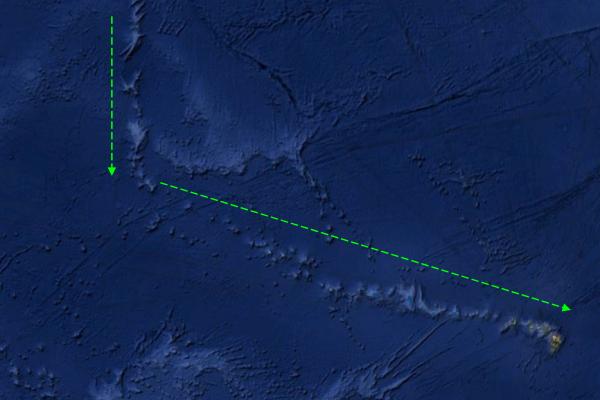
Monaco Bank is a submarine volcano located in the Azores Island Arc. The volcano was constructed on regional tectonic trend connecting the active volcanic island of Sao Miguel (5 volcanoes) to the now extinct Santa Maria Island. Like many Azores volcanoes, the volcano is rift-dominated, built on a NW-SE-trending fissure 20 km south of the western tip of Sao Miguel Island. The volcano therefore has an elongated profile (much like San Jorge Island, Azores) rising to within 197 metres of the sea surface.

Photo showing the sea floor around the Eastern Azores. Monaco Bank is the ridge extending south from Sao Miguel in the bottom centre of the image. Don Joao de Castro Bank rises from the sea floor between Sao Miguel and Terceira. Photo from Santos and Tempera et.al, 2010.
Two eruptions have been documented from Monaco Bank. The first, in 1907 was only discovered because it broke an underwater telegraph cable. In 1911, a second eruption occurred when underwater phreatic explosions created water jets the broke through the sea surface.
The volcano is unusual for a European volcano as it has never been studied. Unlike nearby Don Joao de Castro Bank seamount volcano, whose morphology and hydrothermal vent communities have been studied well.
Lucas Wilson
REFERENCES:
R.S. Santos, F. Tempera, A. Colaço, F. Cardigos, and T. Morato. 2010. Mountains in the Sea, Spotlight 11. Dom João de Castro Seamount. Oceanography, 23:200–201, ( http://dx.doi.org/10.5670/oceanog.2010.83)
NOAA. 1986. Catalog of Submarine Volcanoes and Hydrological Phenomena Associated With Volcanic Events, January 1, 1900 to December 31, 1959. 45 p
Siebert L, Simkin, T. 2002-. Volcanoes of the world: an illustrated catalog of Holocene volcanoes and their eruptions: Smithsonian Institution, Global Volcanism Program. Digital Information Series GVP-3, (http://www.volcano.si.edu/world)
From Global Tectonic 3rd Ed.
“The stability of the boundaries between plates is dependent upon their relative velocity vectors. If a boundary is unstable it will exist only instantaneously and will immediately devolve into a stable configuration… A more complex and potentially unstable situation arises when three plates come into contact at a triple junction. Quadruple junctions are always unstable, and immediately devolve into a pair of stable triple junctions.”
There are three essential types of junctions that make up plate boundaries at triple junctions. Trenches, Ridges, and Transform faults. (convergent, spreading, transform). Whether a junction is stable or not, depends on the movement rates of the various plates that make up the junction. Some orientations are completely stable (Ridge, Ridge, Ridge) others are completely unstable (Transform, Transform, Transform). Others have special conditions in which they are stable, or else the junction will migrate down one of the interfaces until it meets a stable condition.
A good example of that is the San Andreas. When the Farallon plate made its final plunge under the North American plate, two types of triple junction formed. (“A quadruple junction existed momentarily at about 28 Ma, but this devolved immediately into two triple junctions “) A ridge-transform-trench, and a transform-transform-ridge. Each one propagated North or South until it met up with the Mendocino Fracture zone (a transform) or the Murray Fracture zone (another transform). Once two of the three legs of the junction formed a strait line, the junction became stable. (Over time, the Murray FZ has effectively become “locked” and other dynamics further south in the Gulf of California have taken over) Another example of the dynamics of these forces is the Alpine Fault of New Zealand. Though not a full on triple junction system, two separate plates are colliding head on. North of the Alpine fault the Pacific plate is being sliced and part of it drops under the Australian Plate (Zealandia) and south of the Alpine Fault, the Australian plate (Zealandia) is being sliced in two. In each case, the Alpine fault is the intermediary and has become the transform fault between the two opposing trenches. Flower Structures dominate the Alpine fault as portions of it lock and fail over time.
The Azores Triple junction is the intersection of the MAR, and the Terceira Rift. As a transform-transform-transform system, it is one of the most stable configurations that you can get. The problem is that as the dynamics of the three major plates come into play, they can easily upset the balance and turn any part of that junction into an unstable configuration. Once that happens, the junction will migrate around trying to find equilibrium. Toss in a hotspot, it turns into a mess. On geologic timescales, it is quite easy for one massive plate to suddenly change direction. This is evidenced by the Emperor Seamount chain and the Hawaiian island chain. About 45 to 48 million years ago the Pacific Plate changed motion by about 70°. Any plate margin or junction that it was part of would have felt this sudden shift in the prevailing forces.
Now when you take a look at the dynamics at the Azores, it’s pretty easy to see the lasting effects of changes in plate movement.
Take note of where the Monaco Bank is at on this plot. At one time, the East Azores Fracture Zone was likely the dominant transform fault all the way over to the MAR as part if the Pico Fracture Zone.
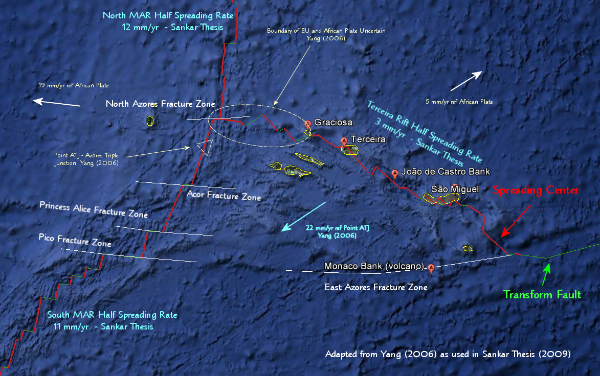
When you take a look at the dynamics at the Azores, it’s pretty easy to see the lasting effects of changes in these dynamics. From Global Tectonics about Ridge, Ridge, Transform: “Unstable, evolves to FFR” (Transform, Transform, Ridge) Or, as seems to be the case for the Azores, snap off a piece of crust and make it a Ridge, Ridge Ridge junction.
Supporting Material by GEOLURKING.
“Global Tectonic 3rd ed” Keary (deceased), Klepis, and Vine. John Wiley & Sons Ltd. ISBN 978-1-4051-0777-8
Upper mantle structure beneath the Azores hotspot from finite-frequency seismic tomography Yang (2006)
Dynamics of Mantle Flow Around The Azores Triple Junction: Constraints from bathymetry and gravity data Sankar Thesis Paper (2009)
UPDATE:
Name that volcano riddle by Suzie!
5631097516
Out of chaos came darkness. Out of order comes enlightenment.


Here is something to keep your mind occupied for a while. The first “chapter” is by Lucas Wilson. GeoLurking started digging when the draft was saved and added a whole lot of valuable information. Thanks to both.
This post might be updated tonight when i get 1 or 2 riddles sent. if not, it will stay as it is.
Bom dia!
Obrigado.
Nice post, thanks Lucas and Geolurking.
There have been surprisingly few historical eruptions of the Azores given the complex tectonic situation and the hotspot; though I guess quite a few undersea eruptions went unnoticed.
Thanks Lucas and GeoLurking for another interesting post.
Thank you for an interesting post, Lucas and GeoLurking 😀
A heads-up to those of you who can witch the BBC – tonight at 9pm on BBC2, the 2nd part of the 3 part series “Attenborough: 60 Years in the Wild” has some hot volcano action:
“2/3. David Attenborough reflects on scientific discoveries in his lifetime that have transformed the way the natural world is viewed – including evidence of how and where life began, the ways in which continents move, and research into animal communication and behaviour. He also recalls some of his more hair-raising attempts to bring new science to a television audience, and clips show him standing in the shadow of an erupting volcano and being charged at by a group of armed New Guinea tribesmen.”
… say, what ever happened to Old Guinea?
……replaced by the Pound!
Speaking of New Guinea. Next year, Waiowa volcano (http://www.volcano.si.edu/world/volcano.cfm?vnum=0503-04=) will be celebrating its 50th Anniversary. Its not often we get to do this (apart from Novarupta this year), but I will probably make a post about it.
Thanks GeoLurking!
Really interesting piece you did.
Guinea (The original Guinea) is still on the west coast of Africa where it’s always been. 😀
Thank you for the interesting post, Lukas and GeoLurking. 🙂
Meanwhile in Iceland: The civil protection have declared alert level 1 for Skeidarársandur because of a possible glacier run though they are not really taking into account at the moment to have to close highway 1 which traverses it. http://www.mbl.is/frettir/innlent/2012/11/22/ovissustig_vegna_grimsvatnahlaups/ The photo is from another glacier run at the same place, probably the one in 1996.
Meanwhile the water is steadily rising in Gígjukvísl, momentarily the main outlet of Skeidarárjökull (glacier) which comes down from Grímsvötn. Chose: Sudausturland / Gígjúkvísl and best “1 month” to compare: http://vmkerfi.vedur.is/vatn/VV_Frame.php?r=22362&load_graph=1&direct=1&station_id=218&station_name=Su%F0urland&page_id=281 It’s at around 120 cm now from 27 cm at beginning of month. The waters of the river Skaftá have also been rising steadily at station Sveinstindur: http://vmkerfi.vedur.is/vatn/VV_Frame.php?r=21886&load_graph=1&direct=1&station_id=218&station_name=Su%F0urland&page_id=281 If you can’t get in directly, take “vatnafar”/Sudurland. Skaftá btw. also comes down from Vatnajökull a little bit to the west of Laki.
It’s a bit strange – caveat: I am just a layman – that Vatnajökull is absolutely without any quakes. Don’t know when I saw that last time. But there is some tremor activity esp. at Bárdarbunga (low frequencies are rather lively) , the movements at Grímsfjall now have been mostly in the high frequencies http://hraun.vedur.is/ja/oroi/grf.gif and – as I think – due to another storm this night: http://www.vegagerdin.is/umferd-og-faerd/faerd-og-astand/faerd-og-vedur/sudausturland/linurit/st021.html
Bit strange that there are no quakes on the southgoing outlet glaciers like Skeidarárjökull or Skaftájökull …
Bárdarbunga tremor chart: http://hraun.vedur.is/ja/oroi/dyn.gif
And quake deprived Vatnajökull: http://www.vedur.is/skjalftar-og-eldgos/jardskjalftar/vatnajokull/
Hi Inge
Sharp rise in strain at Hekla or is this a malfunction do you think?
http://hraun.vedur.is/ja/hekla/borholu_thensla.html http://hraun.vedur.is/ja/strain/1sec/index.html
I don’t know – being no expert.
But I think the first borehole strain data do not tell a lot, because they are just measured in seconds. Last time, Hekla erupted (2000) the strain looked like that (in minutes): http://hraun.vedur.is/ja/hekluvoktun/strain_rate_1500.png As far as I know, Búrfell strain going sharply down is an indicator.
There is a bit of motion on the tremor chards, but really not a lot, compared to others eg. DYN at Bárdarbunga.
But then, Hekla is a “surprise” volcano with very little warning time before she goes action. 🙂
It’s usually a sharp drop that signifies trouble – seems to be working all right now. Nothing happening at Burfell. 🙂
I think Hekla needs to have at least two earthquakes and a negative strain at Burfell. That is the combination 90% sure to give you an eruption within hours. A couple of earthquakes alone can be false alarm, but a large negative strain at Burfell… well I never saw it except before eruptions. But then of course the strain does not come alone if there is an eruption coming, there will be also at least a couple of quakes. But Hekla only gives us really little and short warning
I still bet in Hekla to erupt in early 2013, and Katla by late summer 2014 or 2015. Why so? Statistically, Katla seems to erupt mostly during or right after summer, and Hekla mostly in late winter (but not always!), and the reasons for these trends are unknown. I haven’t seen any such trends in other icelandic volcanoes.
Here’s my entry for this week’s riddle:
Who is bigger and why; Mr Eustace Bigger, esq., or his son, Master Ernest Bigger?
Ernest! cos he is a little bigger ….
Got it in one! Now, who’s bigger, Mr or Mrs Bigger?
Mrs Bigger cos she’s a woman …
A pre emptive strike in case your answer is Mr Bigger cos he’s a man!
We-el…
It is Mrs Bigger because when they married, she became Bigger while he didn’t change.
Duh …. I should’ve got that!
Quite a few ways to spell that name; Bigger, Bagger…
Has somebody had a look at Vulcano lately? (One of the Eolian Islands of Italy.) http://www.ct.ingv.it/index.php?option=com_wrapper&view=wrapper&Itemid=214&lang=en There is a lot of degassing going on now, mostly up to now this was just a bit of fumarolan activity.
It’s perhaps due to a lot of rain and water accumulating within Fossa crater, because the thermo cam does not show a lot of heat. On the other hand the thermo cam seems not really functioning correctly.
So not to deprive you of your weekend riddling fun. Suzie sent a riddle.
Post updated with a Name that Volcano riddle!
slightly OT but I wanted to post this bit by the University of Washington.Burke Museum..
Aboout the Pac NW US Geology.With the various triple juctions and other
dynamics of the interaction
http://www.burkemuseum.org/static/geo_history_wa/Cascade%20Episode.htm
Now that was an awesome read.
Thanks!
Brilliant piece… thanks for that. And people worry about volcanos? Ice is what we should be worrying about:
“Fourteen thousand years ago, the ice was three thousand feet thick over Seattle, nearly six thousand feet thick over Bellingham. The ice last retreated by about 11,000 years ago”
Now there’s climate change for you. Geologically, 14ooo years is nothing.
We have no Idea about what has gone before. We worry about tomorrow when things
that have- and can happen again are-worse.. A local rancher here found a Mammoth Jaw
with scraper marks on it, and it may not have been Native American. Maybe “Kennewick
Man’s”People Clovis point were found not too far from here in Idaho…
Again, we have not a clue…
I will take a stab at the Riddle: Tambora…
Re. the riddle: In 1756 Katla volcano in Iceland had a (probably) VEI 5 eruption (began in 1755, ended in 1756) http://www.volcano.si.edu/world/volcano.cfm?vnum=1702-03=&volpage=erupt
The 18th century was the century of Enlightenment. Montesquieu died in 1755. The same year Immanuel Kant published his treaty Universal Natural History and Theory of Heaven. 🙂
And ALF is born in 1756: http://en.wikipedia.org/wiki/List_of_ALF_characters#ALF 😆
“Immanuel Kant was a real pissant who was very rarely stable… ”
Is there a volcano called Hepatoma? The number beginning the riddle matches anyway.
“Yee?”
Ahh… now it’s
That would explain the “cheerleader” looking girls, one of which had “Yee” on her tee shirt.
Now they are back… so… “Yee?”
If you reverse the number you get the phone number of a truck rental place in Franklin. The words just bring up the Illuminati, Freemasons and various new age spiritualism sites. I have to go off to order a bow and arrow set for my four year old great niece’s Christmas present. 😀
Age of Enlightenment: http://en.wikipedia.org/wiki/Age_of_Enlightenment … ehm … and: cheers to Immanuel! 🙂
And something for GeoLurking: http://en.wikipedia.org/wiki/Chaos_theory
Connection with geology (from Wikipedia): “Chaotic behavior has been observed in the laboratory in a variety of systems, including electrical circuits,…, oscillating chemical reactions, fluid dynamics, and mechanical and magneto-mechanical devices, as well as computer models of chaotic processes.”
Well… since Kant came up, I ran across this while spelunking the web for clues to the riddle.
“Nature even in chaos cannot proceed otherwise than regularly and according to order. ”
Emmanuel Kant
He was an optimiste. 🙂
Beats me… I’m a “Persimmonist.”
Angry, bitter, cynical. (yeah, I made that up)
What a great reading this week! Some links where we talk about Monaco Bank and
Azorean volcanism in general :
ria.ua.pt/bitstream/10773/7993/1/246695.pdf
Click to access Annex_2.pdf
To the riddle may be Krakatoa. This series appears in bold some links with the name of Krakatoa
Cheers Sherine x what a great introduction to the Azores, are you an local?
Thanks Schteve, alas no!
I’m getting Krakatoa and some other Volcanos too….
The Number in the Riddle (5631097516) I think relates to Seconds, after working it out (approx), then would put it around the years 1833-34…I’m to tired to work out the exact date to the nearest month and date, but it is between those years (If I’m right that the number is Seconds that is) …On searching them years, Krakatoa, Kaba and Mount Vesuvius all had eruptions….
I would also go for Krakatoa myself, I did find this site which says the actual times of the eruption/s in 1883 (So it is possible that the number in the riddle can be worked out to one of these times stated):
“At around 5:30 a.m. and then at about 7:00 a.m. on the day of the fatal eruption, the island experienced two huge explosions that caused tsunamis to wreak havoc in the Sundra Strait. Then, around three hours later, at 10:00 a.m., the island exploded and destroyed itself in one huge cataclysmic explosion. ”
http://www.wisegeek.com/what-happened-at-krakatoa.htm
Notice the years though on the above article link, it states at first the eruption date as Sunday 26th August 1883 and but then says 1833…On searching Giggle, Britannica has it as 1833…So I’m thinking 1833 was the correct year….
On searching more about the 1833 or 1883 big Krakatoa eruption, A lot of sites are saying different years…I have read a few articles and it is the same eruption but there seems to be a lot of confusion on the year of Eruption, either that or people put the wrong dates and then it spread around the web….
Geez, My headache getting worse :(…Wikipedia for Krakatoa says 1883 and Britannica saying 1833….
Same eruption, different year…Hmmm, helpppp 😦
Name that Volcano Riddle Hints
There are two ways to solve this riddle –
Either to resolve the relationship between Chaos and Darkness – Geolurking was on the right track below, but its nothing to do with the Maoris.
Alternatively to bring order to the numbers – but before you bring order you need to apply letters to the numbers – scientifically!
Garys, eruptions the most important were 535/36 AD and 1883
http://www.geology.sdsu.edu/how_volcanoes_work/Krakatau.html
Click to access Krakatau_6th_Century.pdf
Krakatoa has its last BIG eruption in 1883. That is a well known event. I dont know how many eruptions happened before. But there was probably another very BIG event in 535 at Krakatoa (unconfirmed) which could help explain the tremendous volcanic winter that followed that year, probably the largest in 2000 years.
Merci!
Thank you Sherine! 🙂
Thanks Sherine, Sorted into international treasures
That 6th century eruption had to be a VEI 7. So Java and Sumatra could’ve been linked?
…and now Kraktau is now the valve that the magma erupts through?
Justly, even if the eruption at this period is not questioned, the most accepted theory on the formation of Sunda Strait is the result of an activity techonique :
http://cyberweb.dmki.or.id/Jasa%20Design%20Website/when-java-and-sumatra-separate/
Who says it has to be related to a western culture?
(forgive the typos, hand transcribed)
From “Maori lore” By Sir George Grey
Every body yammering about finding odd stuff.
How did Charlie Brown put it in the annual Halloween Special?
“I got a rock”
Fluid-Rock Interaction in the Miocene, Post-Caldera,Tejeda Intrusive Complex, Gran Canaria (Canary Islands): Insights from Mineralogy, and O- and H-Isotope Geochemistry. Donoghue et al (2010)
Click to access 2149.full.pdf
Truthfully though, I was looking for something else… completely.
Name that Volcano Riddle Hints
There are two ways to solve this riddle –
Either to resolve the relationship between Chaos and Darkness – Geolurking was on the right track above, but its nothing to do with the Maoris.
Alternatively to bring order to the numbers – but before you bring order you need to apply letters to the numbers – scientifically!
Chaos Crags associated with Lassen Volcanic Centre, California USA…… but I have no idea what the numbers could be. I tried alphabet letters. Lat and Long.Dates… to no avail. My brain hurts now!! Prolly because it’s not been used much this past couple of weeks .
A very interesting Post. Thank you Lurking and Lucas :D.. That sounds like a music hall act 😀
I hope everyone had a lovely Thanksgiving over the Pond.
Hey Diana – last time I used numbers you worked out what they were sooo quickly! Think of a tabular link between numbers and letters! And how is the charming Meg!?
EFCJIGEAF?
I’ll take “cryptovariables” for $500 Alex..
Grr….
Mt Erebus 😕 (fits half the clue)
Mt Siniai is a long shot ….
But here is an interesting rock for the collection:
http://en.wikipedia.org/wiki/Genesis_Rock
Again I was writing too slowly…. 😥
Ding! (Fits all the clue!)
Erebus was a primordial Greek god of darkness, the son of Chaos (Khaos).
Periodic Table – Atomic Numbers
5 = B
63 = EU
109 = MT
75 = RE
16 = S
The letters make up an anagram of Mt Erebus – by putting them in order one is enlightened!!
Got the chaos to darkness and the periodic table bit but was seeking further enlightenment 🙂
I think the riddle volcano is: MT. EREBUS 🙂 !
Using the letters from the symbols of the elements with the atomic numbers 5, 63, 109, 75 and 16.
Atomic number – element – symbol:
5 – boron – B
63 – europium – EU
109 – meitnerium – MT
75 – rhenium – RE
16 – sulphur – S
Looks like it 😀
Mount Erebus – EREBOS (or Erebus) was the Protogenos (primeval god) of darkness, His mother was Khaos Her name khaos literally means the gap, the space between heaven and earth. Khaos was the mother or grandmother of the other substances of air: Nyx (Night), Erebos (Darkness), Aither (Light) and Hemera (Day), as well as the various emotion-affecting Daimones which drifted through it. She was also a goddess of fate like her daughter Nyx and grand-daughters the Moirai. http://www.theoi.com/Protogenos/Khaos.html
SHE walks in beauty, like the night
Noiseless glide with grace not felt
Stillness looms without the light
Cacophonous roar as the dog then yelps.
(It ain’t Lord Byron, but it’s more accurate)
LOL! Classic ‘tread on the dog in the dark’ poetry! 😀
‘Yall saw my 23:23 above.
When I saw this in Wilkipedia… I had to chuckle.
“Valles Caldera (or Jemez Caldera) is a 12 mi (19 km) wide volcanic caldera in the Jemez Mountains of northern New Mexico. It is one of only six known land-based supervolcanoes. ”
Pulling snippets from my lament: 15 in the San Juan Mountains of southwest Colorado, Gila Wilderness–Black Range region, another 10.
Then there are the crapload that we talked about with Bruce’s TVZ series… and I’m currently poking around with my list and the … phenomenal number that are in Japan.
“only six known land-based supervolcanoes” my arse. Wikipedia strikes again (‘swing and a miss’)
Hey, another Kant quote:
“Nature, when left to universal laws, tends to produce regularity out of chaos.”
— Immanuel Kant
Humor is where you find it.
While looking for topographic info on Toledo Caldera… (predates Valles), I found a map called “Frijoles_map_final [Converted]”
Frijoles = “Beans”
No, not because of the huge out-gassing… one of the transects crosses Frijoles Canyon.
I will dig around in my stuff-someplace I have picture of a little fire smoke coming off the top of the liitle dome back in oh ’94 if i can find it. We got called out to the Baca country quite often out of Albuquerque quite impressive once you realize that meadow is a Caldera…
Really love that part of NM and Northern AZ too..
Miss sitting at the Winslow Az. Tanker base and chatting with my old friend Silas Red Deer.Quite a guy…
We all went over this with our gathering of large caldera systems around the world. There are well over 40 “supervolcanoes” that are in the same range as Valles, and that’s only counting large silicic caldera systems formed from subduction zones that show signs of being currently active in some regard.
Supervolcano is a very very relative term if we’re counting caldera systems the size of Campi Flegrei as “super”.
“We all went over this with our gathering of large caldera systems around the world”
Yes we did. I’m still adding to the list as I find more… running the “total ejecta” formula against what I can find. Think of it as a synthetic volume estimate. It’s what probably came out of the chamber to make the caldera of that size… over whatever period of time that it took to do it.
It’s based on published estimates vs known sizes.
Here is some of the data in a usable format.
And a look at the fit of my model… as you can see, there is room for error. It has a correlation of about 0.8915
Pretty neat fit!! One question, why does you bell curve drop off at the lower end of the scale.. is this due to excluding smaller calderas from the sample?
Yes. As a general rule, only stuff that made a notable caldera… and that I have run across, will be in the data. The “ordinary” calderas… which start to get down into crater sizes, are missing.
I really like Geolurking correlation!
Applying this to Icelandic volcanoes we get:
– Snaefellsnesjokull, eruption 2000 years ago, caldera about 2km: a weak VEI6 (some pre-historical eruptions would have been at least a large VEI5 to a weak VEI6 size, depositing ash widely across Iceland)
– Askja, caldera around 3km (nested within a much larger 10km wide caldera), formed during the large VEI5 eruption in 1875. The larger caldera was probably an older and larger VEI6 eruption, during the Pleistocene.
– Grimsvotn, caldera about 4km wide: VEI6 eruption (unknown)
– Oraefajokull, eruption 1362, caldera about 5km: a good VEI6 (confirmed a weak VEI6, 10km3)
– Tindfjallajokull, eruption 50000 years ago, caldera about 5km: a good VEI6 (confirmed as such)
– Katla, caldera about 12km (Sólheimarjokull ignimbrite eruption?): a strong VEI6 to weak VEI7 (confirmed to be at least a mid VEI6, and possibly even more as evidence shows in widespread European ash)
– Krafla, caldera about 12km (old eruption, probably around 250000 years ago), probably around the size of a large VEI6 or a weak VEI7
– Bardarbunga, caldera about 14km (probably some sort of weak VEI7 eruption, but unknown, could have been the responsible for the Saksunarvatn ash layer). In 1477 and 870 Bardarbunga had VEI6 sized eruptions, which deposited wide ash layers around Iceland.
Hekla is missing a caldera, because it only reached the VEI6 threshold a few times, namely the 1104 eruption and the Hekla 3 eruption.
We know from this, that Iceland only had a few VEI6 caldera forming eruptions since the ice age (mostly from Bardarbunga, Snaefellsjokull and another from Askja but only VEI5). However Katla, Krafla and Bardarbunga probably had caldera forming eruptions that nearly reached the VEI7 threshold, during Pleistocene times.
There is regrettably no Snaefellsnesjökull, only Snæfellsjökull http://www.volcano.si.edu/world/volcano.cfm?vnum=1700-01=
It’s a sporadic effort… done as time and motivation permita. You guys have contributed greatly to the work.
Here’s one that I added today… dunno why I hadn’t gotten to it before.
Rabaul – New Guinea – 13.2km x 8.3km based on syncing up a published graphic with Google Earth and measuring the dimensions.
Est total ejected volume – 114 km³
Caldera probably formed in two events, 1.4 ka and 3.55 ka years ago.
“STRUCTURE AND SEDIMENTATION IN AN ACTIVE CALDERA, RABAUL, PAPUA NEW GUINEA” Greene et al (1985)
Did you get Tavui just to the north of it?
https://encrypted-tbn2.gstatic.com/images?q=tbn:ANd9GcSNtxiU1FXVPJ95ZwrEOzBGrUBGU2CHazB_ANjnpUV5h1_W2fKgOg
Nor the other five. That’s a boon.
Thanks!
Is not Tavui part of Rabaul volcanic system, so perhaps nested calderas here like in Askja and many other parts of the planet. 🙂
Haraldur Sigurdsson has not left this one alone neither: http://vulkan.blog.is/blog/vulkan/image/1146218/ He was there last this spring and linked this drawing into one of his blogs (22.6.2011): http://vulkan.blog.is/blog/vulkan/image/1092862/ Showing the supposed magma chamber under the volcano Rabaul. Tavurvur and Rabaul are linked so intimately that they are often erupting in double pack. http://vulkan.blog.is/blog/vulkan/entry/1175373/
You wouldn’t happen to have formation dates for those would you?
Rabaul – 114 km³ est
Vunakanau – 28 km³ est
Varzin – 129 km³ est
Koravat – 94 km³ est
Sikut – 67 km³ est
Nebgmytka – 119 km³ est
Tavui – 128 km³ est
Apropos the Tavurvur image, in case you were wondering: yes, the yellow colours in the sea are due to a submaring eruption at the place. We know something similar from El Hierro.
GVP on Rabaul: http://www.volcano.si.edu/world/volcano.cfm?vnum=0502-14= 🙂
Acc. to GVP there was one caldera forming event at Rabaul just yesterday, i.e. around 540 AD. http://www.volcano.si.edu/world/volcano.cfm?vnum=0502-14=&volpage=erupt
The structures South of Rabaul are not confirmed as calderas…. all that we know (here at VC) is that they are ring fault structures.
If they are calderas, the est volumes are in my last post.
Here is the layout in Google Earth.
Tavui: http://www.volcano.si.edu/world/volcano.cfm?vnum=0502-15-&volpage=erupt
5150 BC +- 1000 years acc. to GVP.
It seems I took first Tavurvur for Tavui, but it is a separate system acc. to this.
According to GVP… they are in fact collapse structures.
That means that the estimates are valid… if they had been, or are pending events.
More caldera structures and collapse dates from New Guinea (regrettably only abstracts, they are paywalled): Witori and Dakataua.
http://www.sciencedirect.com/science/article/pii/1040618295000704
GVP on Dakataua, New Britain, Papua New Guinea: http://www.volcano.si.edu/world/volcano.cfm?vnum=0502-04=
Name that Volcano – Mt Erebus
Erebus was a primordial Greek god of darkness, the son of Chaos (Khaos).
Periodic Table – Atomic Numbers
5 = B
63 = EU
109 = MT
75 = RE
16 = S
The letters make up an anagram of Mt Erebus – by putting them in order one is enlightened!!
Well done KarenZ and Sissel – a Ding each for solving the riddle in two different ways!
Well done! And well done Kilgarrah for the way you managed to obfuscate, befuddle and deceive! The first sentence is verbatim out of Hesiod’s Theogeny and your riddle could be a very condensed synopsis. However, it does not lead to Erebus so you managed to include a red herring as well:
First of all, Chaos (emptiness) came into being, next broad-bosomed Earth, the solid and eternal home of all. Next came Eros (desire), the most beautiful of the immortal gods, who in every man and every god softens the muscles and overpowers better judgment. Out of Chaos came Darkness and black Night, and out of Night came Light and Day, her children conceived after union in love with Darkness. Earth first produced starry Sky, equal in size with herself, to cover her on all sides. Next she produced the tall mountains, the pleasant haunts of the gods, and also gave birth to lifeless waters. All this she did this without the passion of love.
Thereafter Earth lay with Sky and gave birth to Ocean with its deep current… After these came cunning Cronus (time) the youngest and boldest of her children; and he grew to hate his father, Sky, who had sired him.
Earth also gave birth to violent Cyclops: Thunderer, Lightening, and Flash, who later gave to Zeus the thunder and the lightning bolt. They were like the gods in all respects except that a single eye stood in the middle of their foreheads, and their strength and power and skill were in their hands.
There were also born to Earth and Sky three more children, who were big, strong, and horrible: Cottus and Briareus and Gyes. This unruly brood had a hundred monstrous hands sprouting from their shoulders, and fifty heads on top of their shoulders growing from their sturdy bodies. They had monstrous strength to match their huge size.
Of all the children born of Earth and Sky, these were the boldest, and their father hated them from the beginning. As each of Sky’s children was about to be born, he would not let them reach the light of day; instead he hid them all away in the bowels of Mother Earth. Sky took pleasure in doing this evil thing. In spite of her enormous size, Earth felt the strain within her and groaned. Finally she thought of an evil and cunning stratagem. She instantly produced a new metal, gray steel, and made a huge sickle. Then she laid the matter before her children; the anguish in her heart made her speak boldly: “My children, you have a savage father. If you will listen to me, we may be able to take vengeance for this evil outrage: he was the one who started using violence.”
This was what she said, but all the children were gripped by fear, and not one of them spoke a word. Then great Cronus, the cunning trickster, took courage and answered his good mother with these words: “Mother, I am willing to undertake and carry through your plan. I have no respect for our infamous father, since he was the one who started using violence.” This was what he said, and enormous Earth was very pleased. She hid him in ambush and put in his hands the sickle with jagged teeth, and instructed him fully in her plot. Huge Sky came drawing night behind him and desiring to make love; he lay on top of Earth stretched all over her.
Then from his ambush his son reached out with his left hand and with his right took the huge sickle with its long jagged teeth and quickly sheared the testicles from his own father and threw them away. The drops of blood that spurted from them were all taken in by Mother Earth, and in the course of the revolving years she gave birth to the powerful Furies [Spirits of Revenge] and a race of Giants with shining armor and long spears. As for the organs themselves, for a long time they drifted round the sea just as they were when Cronus cut them off with the steel edge and threw them from the land into the waves of the ocean; then white foam issued from the divine flesh, and in the foam a girl began to grow. First she came near to holy island of Cythera, then reached Cyprus, the land surrounded by sea. There she stepped out, a goddess, tender and beautiful, and round her slender feet the green grass shot up. She is called Aphrodite by gods and men because she grew in the froth… Eros [Desire] and beautiful Passion were her attendants both at her birth and at her first going to join the family of the gods. The rights and privileges assigned to her from the beginning and recognized by men and gods are these; to preside over the whispers and smiles and tricks which girls employ, and the sweet delight and tenderness of love.
Great Father Sky called his children the Titans, because of his feud with them: he said that they blindly had tightened the noose and had done a savage thing for which they would have to pay in time to come.
Greek Mythology can be so lurid – the jaggedy toothed sickle and discarded testicles don’t bear thinking too long about!
I had not meant the first sentence to be a red herring – the source below (Encyclopaedia Britannica) identifies Chaos as being the mother of Erebus. But hey its a myth after all!!
http://books.google.co.uk/books?id=JMknAAAAMAAJ&pg=PA265&lpg=PA265&dq=erebus+son+chaos+literature&source=bl&ots=7vWSjclnX0&sig=ZMxHYTlwoEL6x0GmY6ZwXdzTqSQ&hl=en&sa=X&ei=PZSwUOPHOcXb0QX_p4DQBw&ved=0CEIQ6AEwAzgU#v=onepage&q=erebus%20son%20chaos%20literature&f=false
How very true. The toreador isn’t victorious every time, y’know.
Heres a link to the Mount Erebus Volcano Observatory
http://erebus.nmt.edu
And here is a link to Dr Oppenheimer’s new twitter feed – he is off on Erebus:
https://twitter.com/ultraplinian
Great article Lucas and Lurking!!! Put Global Tectonics on my list for santa.
Pretty complex place the Azores, replete with silicic volcanism (pumice) and large subsidence calderas, and all of this close to MOR. From the pdf posted by Sherine:
“In general terms, the rocks of the Azores islands belong to the alkaline basalts series, which contrasts with the tholeiitic character of Mid-Atlantic Ridge rocks. From a petrographic point of view, on the islands Santa Maria, São Jorge and Pico the predominance is clearly of basalts or picritic alkaline basalt, while on the other islands there is major variety of lithological terms, which vary from picritic alkaline basalt to trachytes, including hawaiites and mugearites. More evolved rocks are also mentioned, like comenditic trachytes, comendites, pantellerites or rhyolites, on the islands São Miguel, Terceira and Graciosa.
Since the discovery and settlement of the Azores, in the middle of the 15th century, 26 volcanic eruptions have been reported in the Azorean Region. 12 of them being terrestrial (on São Miguel, Terceira, São Jorge, Pico and Faial islands) and 14 submarine”
Looks like it is trying to rival Iceland for complexity.
It won’t win that competition! 😉 😆
I summarize here this post on Rabaul by Haraldur Sigurdsson http://vulkan.blog.is/blog/vulkan/entry/1175373/ :
Rabaul is supposed to have one of the biggest known magma chambers at a depth of about 3-5 km under the caldera, filled mostly by dacitic magma with 60% SiO. This dacitic magma erupts in most cases by the volcano called Vulcan, whereas at the other side of the caldera and often at the same time, basaltic magma streaming up from the mantle is directly erupted by the volcano Tavurvur. In 1994, the eruption column from Vulcan reached a height of around 20 km, and simultanously (!) the eruptions column from its “brother” Tavurvur went up to a height of around 6 km. This is also what you see on the above incl. drawing.
The caldera forming eruptions from Rabaul could have been initiated by mixing of these magmas. Known such eruptions have been taking place around 550 AD and 3500 BP.
I think there is even more to Rabaul than meets the eye. From Figure 9 of GVP’s
http://www.volcano.si.edu/reports/bulletin/contents.cfm?issue=3607&display=complete
There seem to be at least four calderas and remnants… nested.
Yes, and I think it is very good that we also work on this region a bit even as laymen, because acc. to the a.m. post by Haraldur Sigurdsson, at the time of his post, they had just 5 (!) geologists working with around 60 (!) active volcanoes in the whole of Papua New Guinea which is really next to nothing even for a Third World country.
There seems to be a rather complicated geology behind the intense volcanic activity with at least two suduction zones and two midozeanic ridges envolved as well a plate tectonic movements of about 7-11 cm (!) per year, again acc. to Haraldur Siguradsson: http://vulkan.blog.is/blog/vulkan/entry/1232953/
Sorry for the mundane post… this is a marker so that I can retrieve this on my phone an read it after I log off.
“Caldera formation by magma withdrawal from a reservoir beneath a volcanic edifice” Pinel et al (2004)
Eyeballing the inferred ellipses for the nested calderas at Rabaul, I get
Rabaul-1 – 83 km³ est (main feature)
Rabaul-2 – 53 km³ est (nested)
Rabaul-3 – 58 km³ est (nested)
Rabaul-4 – 52 km³ est (nested)
The Rabaul eruption around 550 AD could have been actually the event triggering the huge volcanic winter recorded in 536 (much larger than the 1815 one), and thought to be caused by an eruption of Krakatoa around that time.
Both Krakatoa and Rabaul are thus two of the most likely candidates to explain that volcanic event, the largest in 2000 years, and still unknown. Well, you also have the Hatepe eruption (Lake Taupo), which was also a VEI7 event.
Rabaul was active in the 20th century too. Here is a wiki on the general history of Rabaul I had an old friend who would get a bit of a twitch when he heard that name.
He was a gunner/bombardier on B-25’s in that area the B-25 had a hand loaded 75mm cannon. That-was his job.”kind of like being a gunner on an old ship of the line in the 18th century-dark, dirty, and dangerous, -the breech cleared my kneecaps by about 3 inches.”
Here is the Wiki:
http://en.wikipedia.org/wiki/Rabaul
I guess the 1937 and 1994 eruptions were pretty large…
Well done Karen and Sissel. At least I was sort of on the right track 😀 This gives me heart to try again next week , but I did laugh at others who developed riddlitis headaches. I must be a bit of a masochist as despite feeling pretty clueless, I still hunt and beat myself up when I get nowhere fast 😀 😀
OT @ Kilgharrah Meg is fine. She has fallen in love with my cooking especially sausage rolls. These can be removed from the cooling tray on the kitchen counter by a quick flick of a paw. The only trouble is that she has not learned to clean up the trail of crumbs that lead straight to her bed.
She has an identity crisis though. She thinks she is an artistic, kitten . A full ball of black crochet wool was draped around the living room, like some monster spider’s web. Her ability to hurl wool and soft toys, socks etc makes me wonder if I should train her towards a professional basketball career.
Recall training is doing well. She went off lead yesterday and came immediately when called. Excellent for only 2 weeks training. I have trained many dogs. Years ago I trained Gun dogs for my Father and his hunting friends ( I never liked the killing though) and Meg is very easy to train compared with some of those.
🙂
Thanks for the update – she sounds such fun!
Stromboli just has sort of a hickup now: http://www.ct.ingv.it/index.php?option=com_wrapper&view=wrapper&Itemid=214&lang=en
Mt Erebus is continuing to bring order to Chaos and bringing on enlightenment!…..http://link.springer.com/article/10.1007%2Fs00445-012-0649-2
Try this one –
http://erebus.nmt.edu/
Web cams to check out the weather!! There used to be a good one of Erebus but it’s not working now.
http://www.antarcticanz.govt.nz/scott-base/webcams
Saturday
24.11.2012 13:39:13 64.631 -16.732 11.7 km 3.2 99.0 5.4 km W of Kverkfjöll
Saturday
24.11.2012 13:39:13 64.631 -16.732 11.7 km 3.2 99.0 5.4 km W of Kverkfjöll
There was also a 2.0 magn. at the same place last evening, both confirmed.
And there was a small swarm on Reykjanes Ridge, incl. a 3.0 yesterday evening.
The glacier run from Grímsvötn has now arrived in the valley, but it is a very small one like in 2008 acc. to IMO specialist. http://www.vedur.is/#syn=vatnafar The water height is now at 166 cm (was around 30 cm beginning of month) http://vmkerfi.vedur.is/vatn/VV_Frame.php?r=20021&load_graph=1&direct=1&station_id=218&station_name=Su%F0urland&page_id=281.
What if this glacial run is due to the event at Kverfjoll?
It doesn’t seem a likely outflow for Kverfjoll, but its still interesting that the earthquakes there occurred at similar time. Or probably the unrest at Grimsvotn (hotspot) triggered the event at Kverfjoll.
Kverfjoll is another high candidate for an eruption in Iceland, and often highly ignored. But not a large volcano on itself. Also very remote, but with a webcam to see.
Just to joke, this glacial run is still very small. 166cm high means I still can be inside the water and stand with my head out! But obviously that would be very foolish thing to do, as I would be carried out straight with the glacial waters and die within seconds (also its freezing water). You don’t need a glacial run to see how powerful the rivers usually are.
In a more serious note, it seems Iceland is becoming back to life. Finally after a month long spell almost without earthquakes. So lots of tension gathered nearly everywhere. Let’s expect action in Reykjanes, Hengill, Vatnajokull, Askja… the usual places..
And eruptions at…?
We can’t really say! But my guess goes (within this decade) to Hekla first, then Askja or Katla. Kverfjoll, Reykjanes and a lateral fissure of Bardarbunga as candidates a few decades from now.
Kverkfjöll is a big and powerful volcanic system http://www.volcano.si.edu/world/volcano.cfm?vnum=1703-05=&volpage=photos which caused a.o. glacier runs in the past and perhaps was forming by these the canyon called Jökulsárgljúfur (here seen down from Dettifoss in northern direction http://commons.wikimedia.org/wiki/File:Jokulsa_a_Fjollum_02.jpg ) – though it is said today that the biggest glacier runs there probably came from Bárdarbunga.
But this small glacier run can’t be due to Kverkfjöll event, because Kverkfjöll is north of the drainage devide under Vatnajökull. And the waters are in Gígjukvísl on Skeiðarársandur. If there were an eruption in Kverkfjöll, glacier runs would go into the river Jökulsá á Fjöllum (photo: the river at the waterfall Dettifoss: http://commons.wikimedia.org/wiki/File:Dettifoss_Iceland3.jpg ), which runs north from Vatnajökull and into Öxarfjörður. It also takes always some time till the water arrives from under the glacier and enters the sander where it can be seen and measured.
On glacier runs (= jökulhlaup) from Kverkfjöll: Geomorphological evidence for jökulhlaups from Kverkfjöll volcano, Iceland by Jonathan L. Carrivick http://www.sciencedirect.com/science/article/pii/S0169555X04000960 (abstract) 🙂
I remember once that there was a large rift-like valley under Vatnajokull, oriented WSW-ENE, separating the mountains complexes of Grimsvotn and Oraefajokull. This valley starts at Skeiðarársjokull and goes then ENE.
So some drainage under Vatnajokull can collect into this valley and arrive at Skeiðarársandur (like in 1996). Not with Bardarbunga, of which melting waters cannot cross through Grimfjall, and these have either to travel westwards through Hágongu (near Hamarinn, as it happened in July 2011) or northwards through Jökulsá á Fjöllum (as it happened in prehistorical eruptions).
If I am not incorrect, this valley hidden beneath Vatnajokull, runs ENE and probably runs near the southern edge of Kverfjoll, near Brúarjokull. There is a very nice article that mapped this, but I forgot the link. If this is so, it could be that the melting waters at the south and eastern edges of Kverfjoll can drain through this valley until they reach Skeiðarársandur (and be confused as originating from Grimsvotn), or alternatively (but I am not sure it this is possible), they could also travel northeastwards through Brúajokull. However I do agree that the most likely draining pathway for Kvefjoll is northwards, through Jökulsá á Fjöllum.
For Esjufjoll, the glacial drainage is right throughJokullsarlon. For Oraefajokull is through all its outlet glaciers around the volcano, mostly westwards (also ending up into Skeiðarársandur) but also some on its SE flank (almost directly into the sea).
But one thing I see (from the excellent paper you mentioned); Kverfjoll has had some powerful eruptions. This is evidence by its large nested calderas, almost like Askja. Also impressive is its evidence for the glacial runs! Very nice pictures on this article!
Bardarbunga has probably also drained northwards, but it seems Kverfjoll has more frequent eruptions than its western companion. However Bardarbunga has had much larger lava flows!
The trouble in Vatnajokull (and across Iceland) is that many of the black and gray ash layers in Icelandic soils, are of unconfirmed origins. They could have originated in Katla and Grimsvotn, but also from Bardarbunga and Kverfjoll. No one has studied this, I guess one would have to study the tephra layers directly at several points on the ice sheet of Vatnajokull itself, cutting many samples of ice cores.
Then, we would know about the eruption history of all these 3 Vatnajokull volcanoes.
Azores and lack of historical large eruptions? Hmm, not really.
Sao Miguel has 3 large calderas, two of them with confirmed historical VEI5 eruptions (the other had an historical VEI4). Historical in the Azores means the last 6 centuries. These large eruptions are well noted in historical records, but they occurred in early settlement, so they did little damage.
Judging at the size of the calderas, the Azores could make up to VEI6 threshold. The largest calderas are these 3 at Sao Miguel island, but also in others islands. These volcanoes, calderas and eruption would be similar in size to Askja, for example.
One interesting place is Terceira island, with a 7km wide caldera (Cinco Picos), the largest in Azores (result of a Pleistocene VEI6 eruption). Pic of this caldera volcano here http://1.bp.blogspot.com/-57_2ZOvh–0/T7TCA_YDCSI/AAAAAAAADMM/jmkLATnMyUc/s1600/Serra+do+Cume+-+vista+da+Praia+da+Vit%25C3%25B3ria.jpg
Faial island also has a large caldera, and then we have Pico island, with the tallest stratovolcano (which never went caldera).
These can be sights of future large activity, but usually where activity is mostly expected (and most damaging) is at Sao Miguel island, which is the most inhabited island and also where there is the largest concentration of large activity, with its 3 caldera volcanoes.
The ash of those VEI5 eruptions, about 500 years ago, would probably only fell barely in Portugal and UK (and probably only little because it is a long distance – similar between Iceland and Europe). However, this would probably be a scenario similar to the Eyjafjallajokull eruption for mainland Europe, if it would occur nowadays. For the Azores, however, it would devastating.
Last large eruption in Azores were:
Furnas 1630, a VEI5
Agua de Pau 1563, VEI5?
Sete Cidades 1444, VEI4
Furnas, around 80 AC, VEI5
Agua de Pau, 2000 BC, VEI5
These volcanoes have other smaller but still explosive eruptions in between their large eruptions (usually around VEI2). In 1713, we had the last VEI3 mainland eruption in Sete Cidades at Sao Miguel. Furnas and Agua de Pau however did not erupted since their last VEI5 eruptions around 400 years ago.
Obviously a new VEI5 sized eruption in Sao Miguel will occur again eventually, because those volcanoes have been now dormant for quite a long time.
Guessing which one of the three is going next is complicate. The most restless one is Agua de Pau

On this image it is the caldera in the middle of the island, while the western one is Sete Cidades, and the eastern calderas belong to the Furnas volcanic system.
The longer the repose time… 😈
One for the experts to ruminate on. Erik Klematti is saying on Eruptions that the activity at Tongariro had little juvenile magma indicating that the eruption may have been largely steam-driven:
http://www.wired.com/wiredscience/2012/11/138781/
* sorry, Erik Klemetti.
Thats not an expert, thats just someone who steals the information from the official geonet site without giving the link and saying that this is not his work.
Check for yourself, there is where he got it from.
http://info.geonet.org.nz/pages/viewpage.action?pageId=3801207
If he d do this here the article would be shortcut and the link added. ( and the guy would get a warning.)
Actually… Dr. Erik Klemetti is an expert. His specialty is petrochemistry. He is more than qualified to make the statement because he has studied the subject (volcanoes) in detail… far more than most of us. He has a good working relationship with numerous Geological agencies.
In fact, most of us would not be here if it were not for his Eruptions site… which is now in incarnation 4.0… and what led many of us to move because of “Disqus” and the kludge of a Conde Nast magazine website.
If you want a good read, look for his article on reading the rinds on crystals in the phenocrysts in volcanic material. Very illuminating as to what they can find out about the magma chamber where they formed.
‘Eruptions’ was put together because there was a paucity of real and accurate (sane) information on new and ongoing volcanic eruptions. Who better to gather the “real deal” data together than an actual Volcanologist? Since Eruptions had been around, many sites following the subject have sprang up… this being one of them.
The difference here is that we swap ideas and theories back and forth, drawing on the expertise from our various fields. There are a couple here who are actually trained in geology and the associated processes, but we are amateurs when it comes to volcanology. Knowing that fact is our other strength.
Of course Erik is an expert, but i doubt that guy who names himself “dry martini” is.
And he keeps pasting the geonet reports into Eriks comments. ( without mentioning where he found them.
Erik has a post up on the topic Tongariro now. http://www.wired.com/wiredscience/2012/11/138781/
Then I missunderstood.
It appeared to be a slam on Eruptions.
NEVER, i admire Erik and his blog and it is my first MUST -READ every morning.
But it´s guys like dry martini that get on my nerves, pasting info and not stating that it is not their own work but someone elses.
@Spica, as you said – “pasting info and not stating that it is not their own work but someone elses” – I hate that. People who do that do not deserve to post their comments on a serious medium (please note: this is meant in general and does NOT refer to E.K.).
Erik Klemetti is not cheating here. First he is a geologist (from Denison University) and second he refers to the geonet pages in his text not only once and links them in, among others your here mentioned link, Spica.
That fits in with the last Hobbit launch event.
But for steam driven… I’m quite impressed. When water flashes to steam, it tries to occupy about 1700 times the volume that it did as a liquid. If it can’t expand, that creates a pocket, ramping up the pressure in the surrounding rock. If enough of it builds…”pop.”
Now here is the nitty gritty that we need to always remember… hydrostatic pressure, the pressure of an open column of water to the air… like a geyser or pipe, keeps any water below about 2.25 to 2.35 km deep from flashing to steam. Because the pressure of just the column of water is too great.
That means that something is going on at about this depth…. magma intrusion, superheated water percolating up above it… something. It essentially points to activity, which we were sort of already aware of because of the Hobbit flinging.
Who will travel the longest distance if used to block the Te Maari vent and why; Peter Jackson or Elijah Wood?
Elijah Wood would have the greatest launch velocity due to the lower mass per unit area, but I think Peter Jackson would retain the velocity longer due to the greater density vs drag ratio.
That ratio will greatly affected by which one is flailing about more. Which one is more sedate?
Gotcha! 😉
Although I cannot fault your reasoning, Elijah Wood is a US citizen while Peter Jackson is a local. Thus in order to plug the vent, Elijah would have to travel the greater distance. 😮
Good one!
Have another?
Aha!
I utterly detest Metallica, but iHeart had been sticking this song in the rotation and I remembered it, but it didn’t sound like I remembered. I hadn’t noticed that it was Metallica playing it until I looked at my phone while it was on. By default, any song by Metallica get’s “unliked” as soon as it comes on.
Must have been some kind of Jailbreak or something…
Metallica? ??? I know they’ve done a cover of this too, but this is Thin Lizzy. I think? (Didn’t check too closely, sorry!)
Yeah, Metallica. I almost puked when I saw who was playing.
Thin-Lizzy I like, but you can keep Metallica.
*Just to clarify, you linked the correct video. I remembered the Metallica bit.
Unrelated item. It wasn’t until I started looking into Pimus’ short cover of Rushes “YYZ” that the lead singers were the Bassists. Turns out Thin-Lizzy is also.
HAH!!
A synthetic drummer…
Tumble Dryers? As a stage prop for their Frankfurt concert?
And here is the Metallica version of Whiskey in the Jar:
Careful, they might sue you into oblivion. Lars needs another gold toothbrush.
R.I.P. Napster.
I’ve just read up on “The Hobbit” project http://en.wikipedia.org/wiki/The_Hobbit_(2012_film) and I must admit it fills me with trepidation as Jackson managed to maim “The Lord of The Rings” almost beyond redemption.
On the subject of Bassist as lead singers… Phil Lynnot and Les Claypool of Course; but let’s not forget Lemmy Kilminster of Motorhead
Motörhead and Lemmy deservedly have a very loyal fan following which, alas, does not include me.
At first I found his work great. As a fan of the LOTR I first found the trilogy impressive. The more I see the film now, the more I find PJ is just what he is. An Horror movie maker given plenty of money. Not that I dislike his 3 films, he follows the line quite well and did not modify too much to make a palatable movie. But I wonder how he will manage to make a trilogy with the hobbit….
PJ is – allegedly – padding with a LOT more backstory about the dwarves and the coming of Smaug than was written in the book. From the sound of it, we’re at least one movie in before Bilbo makes it out of his pantry…
Don’t know what lit the blue touch paper but I got the above from Erik’s own post “New Zealand’s Tongariro has its Second Eruption of 2012” on Eruptions as per the link given and repeated here http://www.wired.com/wiredscience/2012/11/138781/.
Erik, as usual, is professional; has provided his references & links; and, made no pretence of saying another’s work was his.
😕
Be that as it may, he persists with Wired Discuss for which no castigation is too severe. 😉
Lost my Discuss password ages ago and can’t remember which nom de plume I was using for it – so it is lost forever. 😆
Oh come on, be fair; it’s not THAT good!
IMO is now confirming that the small glacier run has arrived in the valley, where they have been measuring it. http://www.vedur.is/um-vi/frettir/nr/2583?ListID=1 The small bit of tremor acc. to IMO indicates the glacier run: http://hraun.vedur.is/ja/oroi/grf.gif
On the photo you can see the water – which is not very impressive, that’s right – under the bridge over Gígjukvísl on Skeidarársandur. The bridge btw was the one to go down in the glacier run – which w a s impressive in 1996 http://commons.wikimedia.org/wiki/File:2006-05-23-190838_Iceland_Skaftafell.jpg . It was reconstructed mostly from wood and with only one runway with some meeting platforms in between.
Icelandic humor, part II : nice picknick place on Skeidarársandur. http://commons.wikimedia.org/wiki/File:2006-05-23-190453_Iceland_Skaftafell.jpg
I wondered what was going in Eastern Vatnajokull on when I saw the 3+ mag and the tremors here. http://hraun.vedur.is/ja/oroi/dyn.gif
Vatnajokull that should be!!
Okay.
Its just a really small glacier run, and Kverkfjöll turning in their sleep, nothing special.
And bedtime for me, too, now. Good night. 🙂
Good night, Inge. Thank you for all the interesting information.
Thanks everyone!
🙂
You ever get so many lines of thought going that you keep getting lost in the number of things you want to look at?
I haven’t even gotten past equation one of “Caldera formation by magma withdrawal from a reservoir beneath a volcanic edifice” and off I go trying to come up with a formula for the change in tensile strength vs load pressure for granite.
Having done that I now realize that I have to go back and look at the Mogi model again, and rewrite my spreadsheet for pressure since I only did it for deflection of the surface stations.
This could be… interesting.
Essentially, what that paper looks at, is the distribution of stress across surface as a function of distance from overtop of the center of the “chamber.”
Further on, (past equation one) they explore the effect of edifice loading and what effect that may have on whether a caldera forms or not. It turns out that there is a window of opportunity for this to happen… depending on a few parameters, such as chamber pressure, depth of the chamber, size of the chamber, whether the depressurization during an eruption closes off the feeder dikes before it becomes unstable etc.
It’s a great read even if you skip the math.
Look forward to the results 🙂
Well… what I have learned so far is a bit interesting.
“Hoop Stress” is what the magma “chamber” feels as whatever inside is impinging upon the walls that restrain the magma.
Using a couple of models that were primarily focused on the “anisotropy of Barre Granite” and the “Flexural Tensile Strength of Laurentian Granite”, I get an average tensile strength of about 11.41 to 11.46 MPa (stdev of 7.8 MPa) for models of the six data sets contained in the papers for the tensile strength. (for loading stress in the range of 0 to 45 km depth)
(Correlations of the models: 0.967, 0.973, 0.986, 0.996, 0.997, 0.991, 0.997, 0.993. So they are pretty good, though the samples are sparse. I figured it was good enough for “generic” granite.)
This fits the 7 to 25 MPa data in this reference paper:
Click to access Some%20Useful%20Numbers.pdf
The way it goes, is that if the “Hoop Stress” exceeds the tensile strength of the “chamber” walls, you get dike propagation. If that dike makes it to the surface… you get an eruption. (or Hobbits flying about if it’s energetic enough)
Here we go with that magic word. In you assume that Mk-1 mod 0 granite is a good representative of whatever country rock you happen to have, that means that chamber overpressures of about 20 MPa should be more than adequate to punch through as a dike. The Hoop stress of a 1 km chamber at 10 km depth is about -20.4 MPa for a 20 MPa overpressure. That is sufficient to keep things rolling to the surface unless the chamber looses pressure by volume loss or degassing. (provided I got the numbers right)
But… this is with no overlying edifice to help weight things down. I haven’t gotten past page 4 yet.
Why granite? That’s the stuff that continents are made of. When molten and laden with gas, it can become rhyolite in the proper setting.
Wow, that was one of the most stimulating reads I have had for a while. I can almost get my head round the maths as well which makes a change. Just some initial thoughts..
1. They seem to be a little fixated on the edifice idea as they assume at the outset, that most caldera forming eruptions occur where there is an initial edifice. I don’t know if this is true. In fact the opposite seems to be the rule to me. They do cover large calderas towards the end but almost seem to treat them as an exception to their model as their model suggests the addition of edifice load makes caldera formation more likely.
2. While I understand the simple geometry involved that increases tensile forces at the surface (as a function of radius from the central point of inflation in the chamber) i have some problems with it. If the failure in the country rock were just a matter of geometry, fault propagation would be from the surface downwards towards the chamber (like the crust developing on rising bread dough). But this does not seem to be how eruptions develop in real life or have I misunderstood something?
I think in practice we have two main scenarios: a) (re)activation of an existing conduit that has become established over time and b) dyke propagation along existing tectonic faults that have nothing to do with the inflation, or at least these tectonic weaknesses are exploited by rising magma.
3. The model excludes the explosive power of volatiles which might be the biggest force of all in shallow ignimbrite forming calderas.
4. The nature of the country rock making up the roof probably also plays a big role. If it still has structural integrity (unbroken sedimentary or metamorphic strata) or is itself the product of past eruptions like in the Taupo Volcanic Zone, could affect the nature of dyke propagation.
I’ve certainly got to go back and read it again 5 times.. preferably with a calculator!
These don’t have edifices, as far as I know: http://en.wikipedia.org/wiki/Volcanic_pipe
And hypothetical volumes of eruption for a pipe of depth 2.5km, assuming all, one third, half and two thirds of the content were erupted.
Exactly. That’s why I got hung up on the first few pages. The tensile strength of the country rock in the chamber wall is going to be the deciding factor of whether internal forces can overcome it and make a new path out.
I imagine that the load setting is what drives the generation of ring fault structures over time. Once those are set up the entire concept of the paper is out the window. (They state as much.) I’m guessing that inflation/deflation over time is going to drive the formation of ring faults… and that is where the load curves and the tendency to initially fracture at the surface come into play. Once they form, it would be pretty easy for them to be erased by erosion… but they will still be there. As time and eruptive events continue through the years… eventually those fractures will extend deep enough to where they can make a difference on how the active chamber behaves.
Now that makes sense to me. Particularly when you see how these things go and up down like yo-yos over geologically really short time frames.
Chamber dimensions guestimated from Inge B.’s links to Haraldur Sigurdsson’s site. A generic approximate.
Four scenarios. Chamber pressure 1 and 2 MPa increase, (filling) and 1 and 2 MPa decrease (draining/erupting out)
The sign change happens at about 3.80 km out from the center. Beats me if that is significant. I would think that the maximum wear would be where the first inflection point is from out from the center, the region that has to adjust from one state to another every time it cycles… somewhere around 2.59km in the plot. This sort of fits with Sigurdsson’s diagram of Rabaul… having the actual chamber extend out from the caldera walls a bit.
It’s also possible that since the zero crossing generallly doesn’t encounter either type of stress (or minimal), that it would be the demarkation point for the furthest point out that a caldera could form.
Ideas?
I am not so much into formulae, but I found a paper on New Britain / New Guinea calderas, I don’t know if you have it: http://link.springer.com/article/10.1007%2Fs00445-010-0401-8?LI=true#page-1 Chr. McKee, A remarkable pulse of large-scale volcanism on New Britain Island. As a lot of Springer papers, among them the Bulletin of Volcanology, its still open access til end of month.
Hi everyone. Maybe this simplified model helps understanding where Geolurking is on about.
When finding out where pressure and tension forces work i always like to simplify the system into little snapping blocks.
To compare it to Lurks graph, you see that during filling you have surface tension at the center, 0 presure at 2,5 km and maximum surface pressure at 5 km, the chamber wall. Inside the chamber the forces are opposite.
I’d expect ring dyke intrusions should happen fairly easy during inflation periods.
Geolurking, at the zerocrossing i expect minimal stress. The roof only has to bent in the center and allong the outer radius. Well it should more or less change smoothly from a positive bent to a negative one. Half way out from the center there is no flexure at all. The zero point crossing point.
You cannot add images here on a wordpress blog. I dragged the pic over from Tinypic and added it. Spica
Etna is showing a glow on: http://www.radiostudio7.it/webcam.asp?web=1&id=1
HT is not elevated at the moment: http://www.ct.ingv.it/index.php?option=com_wrapper&view=wrapper&Itemid=201&lang=it
Snicker time…
http://www.guidestar.org/organizations/87-0745629/alliance-climate-protection.aspx
New post is up Answers to the riddle(s) Mt. Erebus and…