
Grimsvötn 2011 eruption. Photographed by Jóhann Ingi Jónsson.
I have been tracking what is happening at Grimsvötn since the last eruption and the entire hubbub at Bárðarbunga. If you look at the GFUM GPS station you can see the slow and steady inflation speeding up a bit before the intrusion into the Bárðarbunga system started.
In the days prior to the intrusion the speed of inflation increased a bit and the normal southward motion increased too. As the intrusion hit there was a rapid south movement which was to be expected since the entire area was affected by the rapid intrusion into Bárðarbunga.
Later the southward motion changed into a northward motion as the magma started to rapidly move out of Bárðarbunga and the inflation continued at the same slightly increased speed. This was a bit unexpected and I started to speculate that there might be magma arriving into the volcano due south of Grimsvötn called Háabunga.

Map showing the location of many, but not all of the known volcanoes under Vatnajökull.
It has not until now been known if Háabunga has an independent magma reservoir even if it has been suspected. Not much is known about the eruptive behavior of this volcano, but it is known to have erupted during the time after Icelandic settlement. It was though not known if it was due to fissure eruptions from the central magma reservoir under Grimsvötn or from an independent magma reservoir.
If the northward motion had been entirely due to deflation of Bárðarbunga there would have been a diminished rate of upward motion showing at GFUM, or even downwards motion. Instead the inflation continued unabated, a sign that not all was right.
And due to it being upward motion the source of the inflation had to be south of the GPS station. But, so far it was a bit speculative and also the amount of inflation was rather insignificant for such a large volcanic system.

Image from University of Iceland and Sigrun Hreinsdottir.
Yesterday the northward and upwards motion magnified a lot. In one day the GPS has moved 4 centimeters to the north and 3 centimeters up. This point towards a rapid intrusion occurring about 5 kilometers south of the GFUM station and due to the lack of earthquakes the intrusion must be happening into a pre-existing well evolved magma reservoir.
This intrusion is not yet visible at other close stations, but one should remember that there is a mechanical delay before the movement shows up there. Somewhere tomorrow we should see Hamarinn moving westwards and slightly up. And not until we have data from several stations we will be able to estimate the amount of intrusion that is happening. If it affects several far out it is a large one, if just a couple close by it is small.
So far I will go for a small intrusion due to the lack of earthquakes. Someone asked if this might be magma being squeezed out of Grimsvötn due to pressure from Bárðarbunga, but that would not show any net upwards motion, if anything it would create a motion downwards as we currently see at Bárðarbunga.
Now, will this cause an eruption?

Image from University of Iceland and Sigrun Hreinsdottir.
It is hard to say for any volcanic system that has unknown characteristics. I can though say this, before anything will happen we would need to start to see earthquakes that slowly or rapidly transform into a large scale earthquake swarm like we have seen at Bárðarbunga. After that we would see harmonic tremor starting as gas was released as the magma moved upwards.
My personal guess is that we would see an explosive onset and that it after that would transform into a Gjálp style ice lava interaction eruption with small scale explosivity. This is though an extrapolation, but I think it has merit.
CARL
Reminder: There are still a few riddles left! (Check the link at the top of the page!)


They just zoomed in again on MILA 2 but now as much as before….to me, this is the perfect spot, Bardarbunga just behind.
Here is the new “zoom”
yup…and for those who may not know, in this view, Bardarbunga Caldera would be up and a bit to the left of the lava curtain.
A bit and for fun, since I wasn’t around at the Friday bar. This is exactly what I would expect the Bardarbunga dragon to look like. Would explain the caldera subsidence, the fissure eruption and the stronger quakes.
I hate it when the Parazzis catch me before I have had coffee…
I know the feeling. 😀
Haha, totally, yes, how did you know?
Oh! That was scary . I really shouldn’t watch stuff like that just before bed time 😦
I know, I should not be out flying before having had coffee…
Greetings and good evening Lord Carl!!
Trust you are well and in good spirits!
Much better now that I see good old ‘Orrid 🙂
I must though confess that your latest evilitude of a riddle made me look deep into a bottle…
Hello, still lurking and reading everything I can, we travel to Iceland on Wednesday and I’m very excited but pretty worried too 😦 any advice would be gratefully received!
Also, is anyone able to explain what is occurring on the Smjorgil tremor chart? I know it relates to a different area of Iceland but it looks somewhat alarming to me. Sorry if this has already been mentioned, have been away from computer all day and struggling to catch up.
Many thanks for your most educational blog, I will certainly continue to lurk even when this is all over!
well that’s off the chart!
I noticed it doing something similar a week or so ago, although I don’t recall it being quite as high.
This site is not observing copyright to my pictures and has NOT asked permission.
Linking full size is insault, only thumbnails are usully allowed and by permission.
http://1roxxfoxx.blogspot.com/
If you are logged in with Google (blogspot blogs are hosted on blogger,com, which is Google’s blogging platform), you can report abuse for this. If you are logged in, you should see a bar on the top of the window, where it says More -> click on the arrow next to it and select Report Abuse.
Thanks. Carl already done that. Pictures delited and re-inserted (fewer tho).
I have reported it to Google DMCA.
If needs be a lawyer will be on it.
Seems word spreads fast on Internet. Gone now!
But proof telling link remains (saved it for evedence)
http://1roxxfoxx.blogspot.com/2014/09/bararbunga-at-holuhraun-new-images.html
Islander, of course your copyright should be fully respected. I would like to take the opportunity to tell you how fabulous the photos are and most appriceated here on VC.
Thanks
Which photos? I hope I didn’t use one. If so I would like to know to try to remove, as it was unintentional if I did.
If you did, I like see link for approval/or-not, ok?
I checked and I didn’t…I didn’t know what it was about and wanted to be sure.
It looks like she’s linked to your images on Flickr. I noticed a couple of days ago, that if you insert the page link into a WordPress post, it actually posts the image. I’m sure it never used to do that, as I used to have to grab the image url from the image info page in the past. Perhaps a request to post a link to a Flickr gallery might rectify it. There’s no guarantee though, as so many people are ignorant of copyright (and many don’t really see why it is such an issue, as if they have every right). I also note that she credited the IMO, but failed to credit you.
Yes, its linked. “Thumbnails” usually are accepted, with credit. But these are full size. And that need be asked or paid for. Following this site (VC), some sites are mirroring (reblogging)
the Volcanocafé, but only one French site has permission.
And that would be our friend George Vitton…
Painted sky

Did something just go boom across the way?
The GFUM gps is back to normal but to me it did not look like ice buildup??
The with ice the signal becomes random, this moved in a regular fashion and the east value hardly moved
Sure looks like something is going on with Bardarbunga based on Mila 1
Is it a big mushroom-style explosion that expands within 5 min to cover the entire field of view?
Like this:
https://volcanocafe.wordpress.com/2014/09/13/rapid-inflation-at-grimsvotn/comment-page-4/#comment-155715
If not, then it’s just clouds. 🙂
Hmmm – maybe somewhere in between a big mushroom and a pretty sizeable burp. Are those proper volcano terms? It’s big. 🙂
No, it’s not big and it’s a cloud. Please, follow the link above to see how it looks like for real when a central Icelandic volcano erupts. It’s *enormous*, it’s not a cloud, it’s more similar to an atomic mushroom and you won’t have to ask when it happens. You will know.
I’m looking at the Bard 1 cam right now, and I see clouds.
Just clouds. Beautiful sky at sunset.
Does this look like a nice fluffy cloud to you? This is how a real eruption in Vatnajökull looks like. Grimsvötn 2011. One nuke per second energy equivalent… seriously unfluffy.
Thanks for the vid. I have seen an eruption before in Japan. I understand it goes up very fast but there are clouds being created at rapid rate across the way. Maybe just an oddity weather condition that I haven’t seen combined with the sunset. It sure looks like its being created (rapidly) from the ground like steam.
Mila cam 1 GMT

Finally up from my fevered sheets………… i see the awake had quite a discussion on an eruption on the “Big B” and what it would look like. All helpful info. Just to beat a dead donkey, i didn’t say an eruption was starting… i said something weird was going on. And it was immediately after a larger quake. i live across from Mt. Redoubt and have a pretty good idea what an eruption looks like. (sadly… cause believe me, You wouldn’t want to live with the ash…. it doesn’t just go away when the eruption is done) But what i saw wasn’t a normal cloud at all…. now that i’ve time to think about it, i’m thinking perhaps…it was a displacement of a landslip. Landslides can do odd things when big enough. And remote too. Interesting discussion anyway. i’m reminded of the early weather reports in England when ‘Dragons’ were reported to have crashed thu the countryside wrecking havoc. All the Best! from an improving but still much under the weather, motsfo
If Bardabunga and Grimsvotn had a band…
With Þórðarhyrna on drums.
🙂
I understand that it’s not reassuring to see a cloud grow in height but I still think it’s a cloud … smoke from a volcano would rise faster in my opinion
It’s just a cloud (see Carl’s comment above with Grimsvotn example). And if you don’t mind me correcting, volcanoes don’t emit smoke, as there is no fire, they emit ash (broken up particles of rock).
It’s even less reassuring when the image freezes in mid expansion in an odd shape :P. I don’t know for sure, but I suspect it’s convection as it goes over the glacier.
I’m with Motsfo on this one. We have the very sudden appearance of a cumuliform, convective cloud out of an inversion which is keeping the vog down, and in an otherwise unconvective, quiet sky. And somewhere around the edge of the ice. I’ve kept out of the cloud argument since the dawn of time because they were just clouds. But … I’ll eat my hat.
I join in with the hat eating. Don’t forget that you are looking at a huge plateau like structure of Ice. On the other side, beyond the horizon you can see, is the North Atlantic ocean. The coast is a very narrow strip of land. The ocean is relatively warm at this time of year. The air currents look pretty stable at the moment. No high winds. Therefore there will be cold air mixing with warmer air over the glacier which will produce peculiar shaped clouds .Not expert here but knows enough about clouds & weather from my youth messing about at sea in small boats and as a member of a farming family. In my youth there was no TV, Computers and the like. We learned about local weather forecasting by being taught to watch clouds. I still watches them before I hangs out my washing. :
Motsfo I worry about your fevered sheets. You are unwell? Have a nice hot coffee and keep warm. 🙂
If this was a normal cloud, it was the fastest expanding and upmoving normal cloud I ever watched on a webcam. I did not watch too many, though. I think there is a little confusion regarding the meaning and interpretation of our observation. People argue that an eruption would look differently and show examples. Good point. But noone really said “eruption”, it was rather “something strange going on”. I do not know much about geology, but I would assert between “nothing happened” and “full scale eruption”, there would be a whole spectrum of other more or less volcano-related possibilities or events that could have happened and caused some form of visible result, like a short-lived steam cloud, or some thermal local weather phenomenon in connection with the glacier and cooling air. It all happened in the same area and right after the 5.3 quake. Maybe people are too focused on the “impending doom” of a huge eruption. Lets pretend our eyes did not deceive us and it was nothing weather-related (too quick): What else coud it have been?
(To clarify: “this cloud” refers to the events we talked about earlier, not the one right now on the images posted here on the page. This new one I did not watch, seems connected to the glacier).
It was small cloud, forming very near. Deception to “Eyball Mk.1” 😎
Note to readers. Please take screenshot, point out object in questiom, upload and ask.
Else its usually too late for “experts” saying on or off.
It so happns I was “trained” MET bbserveration, know how to read couds fairly well
and used write down in reports for IMO (when I was young) 😉
*next Dragon please fix typos. Need new glasses.
Ontop of that Islander is also used to stand a little bit from volcanoes as they blast away and take pictures… so he knows intimately what the difference is between a fluffy cloud and a big honking volcano.
Yep – Size matters *whistles innocently*
Sorry for stirring things up. I will just sit back and enjoy the view. Cheers.
Has anyone been able to access the Kverkfjöll camera today?
Sorry, I do not have the link of this camera
Give my best regards to Madamoiselle X.
Bisous 🙂
I haven’t been able to access any of their webcams at all.
If you go here it gives all of the days shots and there is a button on the bottom that plays them in sequence
You have to take out the spaces and the date has to be manually changed in the link
http://brunnur .vedur. is/myndir/webcam/2014/09/14/webcam_mogt_kverkfjoll.html#
Cool 😀 Thank you
I must admit that this cloud will intrigue me, it deforms and reforms but do not seem to move

Typical Mountain wave clouds tonight. All are normal.
I got my screenshot a little bit earlier. Looked bit different then. And it rose up in just few seconds.

It’s the same as the previous image. I think your page has frozen 😉
This cloud is different from what i saw but nevermind…. . But this one is weird too…. can it have formed over another small rift eruption??
and i’m meaningAlze’s photo of course.
Typical Mountain wave clouds tonight. All are normal.
*repeat after me*
That cloud is long, low and wiggly. I expect it is just fog off the glacier, but it might *just* possibly be a new fissure…. No hot bits, though.
Colours inverted here – often shows more detail.
Instead of “enter your comment here” in the box, can’t you put “It’s a cloud. Seriously, it’s just a cloud.” … It’s page after page of “omg omg what a weird cloud, is it erupting?!?!” ..
Guess why the Dragondoom are posting that timelapse now… 🙂
Haha yeah, I hope people see it. You should pin it to the bottom 🙂
‘Cos its so fluffy and cute?
There’s a new post to clarify the distinction 🙂
Raises hand in the air….
Dragons….or anyone who may know….how far away was the camera from the Grimsvotn eruption?
I don’t know how far away but even from twenty miles it would be pretty obviously NOT a cumulus cloud.. Lets face it the small plume from the fissure we are seeing can be seen
from Akureyri and that’s 40 miles? away. That plume doesn’t look like cumulus clouds !
Oh, I wasn’t implying that at all! Just curious, cause of all the details you could see in the cloud formations. Wasn’t insinuating anything like that at all!
Mila cam 1 just zoomed in great view now
It’s not a cloud
It’s Bardasboobie
DragoSquirtingCoffee
I’m back from a weekend away and happy to see things are ‘normal’ i.e. someone saw a cloud! 🙂
Fog! South wind blowing over glacier, coming down on the plain. I wish I could find some daylight pictures. You can’t win – either the wind is blowing fumes over the camera or you get fog…..
Makes sense – the warmer air with moisture (Atlantic) cooling down and condensing over the ice.
An hour witn no EQ whatsoever. Big one cooking, eh? Before the last 5,3 there was 1h17m EQ silence.
What, a coffee-squirting boobie?
Well THAT would certainly be a hit! If your girl had that you could get some lovin AND your coffee all at once as soon as you wake up! Win+Win
Hello again!


While talking about clouds: I snapped some pictures this evening around 1700z of the haze in western Norway, this time seen from ground level…. It is the same, perhaps wih a more tan colour to it. I have not felt any sulfur smell (yet), but others in the area have. The weather has been nice, some sunny days, some not. Some calm days, some windy. But the haze is the same. I’m really more coming to belive something about this haze is delivered from Island. But of course, I can be wrong… I’m living in the area marked with a yellow ring on the map-picture.
On behalf of all Icelanders, sorry about that 🙂 I hope it won’t get worse and bother you much. Western Norway is very beautiful by the way.
No problem so far. I just think the beforementioned term “MiniLaki” is standing stronger. And thank you for liking my country! We were hiking the “Laugarveien” from Landmannalaugar to Thorsmork some years ago. An awesome trip in beautifult weather (temp record, I think)! highly recommended. Island is a fantastic country, I’ll take it a millon times before sunbathing in the mediterranian area…
Anyway, I think we crossed Bardarbungas system on that hike. Somewhere around Hrafnisuskr?
Hi Norvald and welcome 🙂 What a very beautiful part of the world you live in . I do hope The haze dissipates soon.
My step son lives in Sarpsborg 🙂
Hello Norvald,
Close to Floro?
Here is quite an interesting report that was realised around 6 hours ago
http://www.theage.com.au/national/education/seismologists-predict-another-icelandic-volcano-is-about-to-blow-20140912-10fqtf.html
Grimsvotn must be feeling very left out and unloved 😛
It’s OK as a general overall view but I noticed several inaccuracies. Plus the film didn’t match the spoken words at all.
“And yet large earthquakes often come in clusters lasting for days or weeks.” For some reason, people think that clusters of events or things must be significant. But nature is lumpy. If things were randomly distributed in time or space, one would expect clumps. Of course, things are not always randomly distributed, and sometimes clusters are significant! but not always.
on Pyrite’s *wink* request Hekla.
Oh what a nice fluffy cloud!
(Sorry could not resist.)
Rofl 😀 Naughty 😀
* hand over mouth* tee hee
i know i have that some times to

Oh, i’m even laughing at that one………. 😉 Best!motsfo
LOL! 😀
normal cloud … nice landscape
normal? http://upload.wikimedia.org/wikipedia/commons/a/a7/MSH80_st_helens_eruption_plume_07-22-80.jpg
Where’s the sharks? 🙂
But – its not Pink!
little piece fixed *no need to fix link* http://i.imgur.com/UUQlKk7.jpg
and black and white. http://i.imgur.com/gXZYgPi.jpg
Off topic – but I’m flying to Sicily tomorrow to have a poke around Etna – cross yr fingers that it blows some smoke for me
My wife and I drove our vw camper there in 2009 spending a month in Italy. The last week we spent in Sicily so I got to see 3 volcanoes on that trip.. Mount Etna Stromboli and Mount Vesuvius.
I think my wife is just starting to realize that most of our holidays involve going somewhere there are volcanoes hehehe.
Have a nice journey! Some years ago we stayed a fortnight at the coast just east of Etna – in November, so very few people were around. It was just great to go out to the balcony even in the middle of the night and to stare at the majestic shape of Etna. And of course, every morning I jumped out of bed to see it again – just before usually later on the top would be wrapped in clouds again. Boy, Etna attracted a lot of clouds in those days – epic rainfalls every second day, while it stayed bone dry to the west of the volcano, lol.
I got some pics when I was out there my camera was not the best.


This pic was from a ferry going past Stromboli
This pic was in an electrical storm we where wild camping on the beach not far from Etna.
Great, thank you. When I was there I was still using slide films, so not easy to share.
It was also November when we visited it did rain a lot but the sea was still warm. The locals where amazing and there was hardly any tourists around.
The cliffs of marble amazed me and in the old town kerbs and shop fronts covered in marble. The geology of that Island is incredible.
This pic was taken from the beach about 10 kms from Etna. The holes you can see in the rock are trial holes to find marble. I went and explored a few and they ran about 100 meters into the rock.

Nice! Thank you and a good night to lovely Ireland!
Give regards to Boris Behncke (sp?) if you meet him
I have a good friend there…she lives practically at the base of Etna. She sends me STUNNING photos regularly. She has no fear whatsoever and says, “If I have to go, I want it to be while looking at Etna!”
Kat did you ever hear of kraftwerk very much like the orb
No, I haven’t but I will check it out 🙂 Thank you
Your age maybe showing
Source IMO new GPS sensor information
Bit of a climb even on the three hour adjusted line?
What a very interesting thing to watch in real time
Must hand it to the guys who flew up there and put this instrument down, that must have been a very strange feeling to know what may be going on below your feet
Yeah could be a few cracks opening up there?
I was walking up there week ago, near that thing, did not scare me
Scratch that. Meant Holuhraun.
Almost like it’s being fed in between the subsidence. It’s started levelling off again now.
let’s see if we get a bit of a rattling soon.
Looks like it didn’t need a rattling to go back on its downward trend. Makes you widh you could see a more detailed view in the days leading up to the fissure eruption to see what was going on.
Yes, that would be nice. For the near future, I am wondering whether any rapid increase OR decrease might be a trigger. Just playing with possibilities.
Probable explanation is lava intrusion in the crater, lifting the ice floating on top of the crater lake.
May the ice is melting under the glacier and the ice is sinking into the lake?
Maybe the water broke… (water underneath drained away)
I thought Bardar had a baby a week or two ago :P.
Ha ha! I was about to say the exact same thing but you beat me to it *high five*
I can’t remember how many weeks old BardarsBarna is now.
Might have to change the name of this post to”Rapid inflation at Bardarbunga”?
Nop.e likely Ice on the antenna!
Hahaha. 🙂 My background is in auditing. When I saw “ice on the antenna,” I almost laughed out loud. They can’t get accurate measurements because of the weather? So how much of the data they publish is inaccurate? It’s not as though snow and ice are exactly rare there! 🙂 how do we know when measurements are correct and when they’re not?
I am so sorry……But I really couldn’t resist this………….The old Timers will understand . 😀
Where did you find this – it is so funny!! 🙂 And perfect for us! 😀
I googled Fleecy sheep clouds 😀 isn’t the internet wonderful? 😀 I rather fancy this game 😀
Those aren’t sheep, those are woolly hippopotami!
That is wonderful – rated the full five grins! 😀
Still trying to figure things out. I am now guessing that seismographs are no longer recorded on drums; that “drumplots” is just an old name now applied to computer-generated graphs; and that the tremor plots are aka drumplots. Is this correct please?
Yes, basically, but (old) drums are still in use (I think)
Oh thank goodness. I couldn’t figure out why I could NOT find any drumplots or links to them, only tremor plots. Also I couldn’t figure out how what I see on the tremor plots could possibly be recorded with a pen on a rotating drum! Thanks.
Nice timelapse video.
Yeah its pretty cool with an upside down curvature
Smjorgil.
I’ve seen the strange tremor plot mentioned several times lately, but never with any conclusions, debate or really informative inputs. Please could someone who knows something please put our minds at rest about this, because to my novice’s eye they look like huge great harmonic tremor pulses, getting substantially bigger in each wave… but with very few quakes anywhere near it, which I guess means that not much is actually happning in the crust. I’m beginning to think it can only be a graboid. Snoring.
Thanks for any insights into this one. 🙂
Where do you see this?
It’s the normal hraun.vedur tremor plots – which I think we’re being asked not to post… I’ll be more than happy to link you to the smj.gif if a dragon says, “aye”…
here’s a screenshot of it, from the IMO site, under Tremor Graphs
Wow big increase in amplitude of tremor?If that is sustained that could be interesting😮
Thanks for that! 🙂
I have answered this – Twice!
Its wonked, possibly broken and/or showing wind noise now.
Three time now. Smjörgil is showing that likely is not eartquakes related.
Can be water, wind, rockfalls or mudslides. Or broken windmill even. Period.
Before posting a question, it is possible to search the blog for a term to see whether it has been mentioned before, e.g. Control-F “smjorgil” (though you do have to search each page separately)
Ah, ok – thank you, and sorry for missing the previous comments. This is the problem with huge numbers of messages – it can be hard to keep up, especially when most of one’s time is devoted to other subjects. I did try the control-F, but obviously on the wrong pages… I think I’d better revert to watching and lurking.
New post is up: https://volcanocafe.wordpress.com/2014/09/14/is-it-a-plume-is-it-a-cloud/
New post is up! https://volcanocafe.wordpress.com/2014/09/14/is-it-a-plume-is-it-a-cloud/
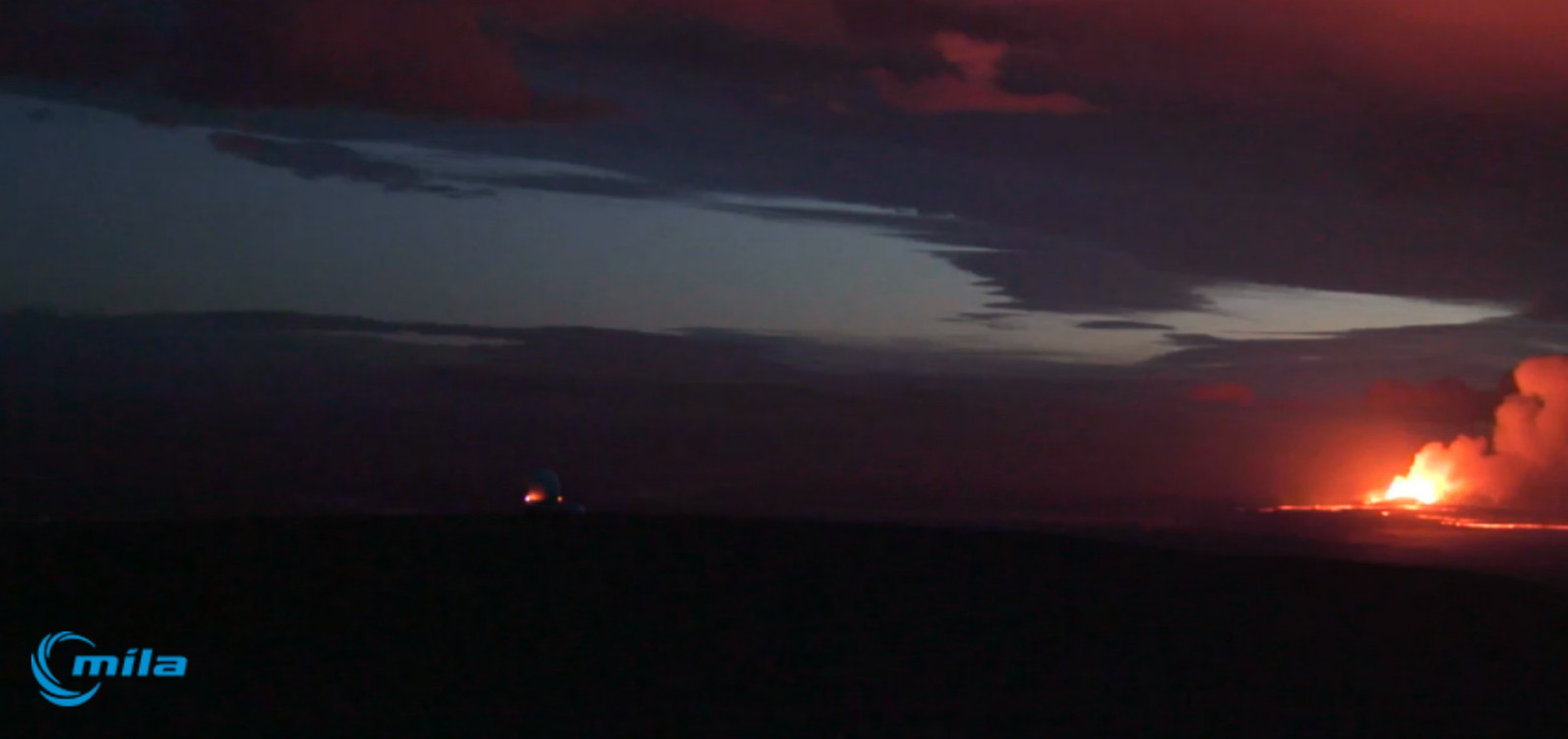
Latest Mila 1 webcam

Caught up, Good Morning 🙂
Thanks to Alze for the supersized screengrab 🙂
and Scott for the latest one just above.
Clearly shows the lava flow spreading to east and northwest into dips on the plain. As reported by the Jarðvísindastofnun Háskólans.
I believe this is because the advance into the river close to Vadalda has been slowed once the low points on the plain are filled the advance will resume. 😉
usual disclaimers, not expert etc.
Latest screengrab mila 2 still obscured
