
The March 1944 eruption of Vesuvius by Jack Reinhardt, B24 tailgunner.
Vesuvio in Southern Italy and alarmingly close to the huge conurbation of Naples has been dormant since 1944. It was not always so quiet; as well as numerous and sometimes hugely devastating eruptions documented since 79 AD, the last 285 years have seen significant eruptions in: 1631, 1660, 1682, 1694, 1698, 1707, 1737, 1760, 1767, 1779, 1794, 1822, 1834, 1839, 1850, 1855, 1861, 1868, 1872, 1906, 1926 and 1929 and 1944. There have been few periods of actual dormancy and these have been mostly short lived, the repose since 1944 is the longest since before the major eruption of 1631….
The following images are of eruptions between 1760 and 1868; chosen by me entirely based on what I like. I have included some basic information about each event, courtesy of: http://www.volcano.si.edu/volcano.cfm?vn=211020 but it’s important to remember that some of these images will be more realistic than others. Many of the paintings are of the Romantic type and some will have been painted from imagination and/ or based on earlier works. Each artist is shown only once though some of them, notably Volaire and Wright painted multiple pictures of the subject.

Eruption of Mount Vesuvius. Charles Francois Lacroix de Marseilles. 1762.
http://fr.wikipedia.org/wiki/Charles_Fran%C3%A7ois_Lacroix_de_Marseille
This depicts the November 1744 to January 1761 eruptive period, which reached VEI 3 and affected the summit, upper south eastern, eastern and southern flanks.

Eruption of Mount Vesuvius. Pierre Jacques Volaire. 1777.
http://en.wikipedia.org/wiki/Pierre-Jacques_Volaire

The Summit of Vesuvius Erupting. Micheal Wutky. 1779.
http://de.wikipedia.org/wiki/Michael_Wutky

Mount Vesuvius in Eruption. Jacob More. 1780.
http://en.wikipedia.org/wiki/Jacob_More

Vesuvius with a View Over the Islands in the Bay of Naples. Joseph Wright c.1776- 1780
http://en.wikipedia.org/wiki/Joseph_Wright_of_Derby
Joseph Wright apparently never witnessed a full on eruption of Vesuvius, although he may have seen some minor activity when he visited Naples in 1776, this did not stop him making around 40 paintings of her eruptions, it must have been a useful money spinner, aristocrats who had made the Grand Tour simply had to have a painting of Vesuvius as a souvenir. This period of eruption began in February 1770 and ended in October 1779 and was an estimated VEI 3 affecting the summit, north, north east, south east and eastern flanks.

The Eruption of Vesuvius. Abraham Pether c.1810
http://en.wikipedia.org/wiki/Abraham_Pether

Painting of Mount Vesuvius Erupting in 1812 as Seen from the Ponte del Maddalena. Unknown Artist.

Mount Vesuvius in Eruption. JMW Turner. 1817
http://en.wikipedia.org/wiki/J._M._W._Turner
This article would not have been complete without Turner’s rendition of an eruption, whilst somewhat impressionistic, he captures the awesome power and wonderful colours brilliantly, there are even hints of volcanic lightning. The eruptive period shown here began in January 1796 and ended in November 1822, it affected the summit and upper flanks and reached an estimated VEI 3.

Eruption of the Volcano Vesuvius. Johan Christian Dahl. 1826.
http://en.wikipedia.org/wiki/Johan_Christian_Dahl
This image shows the eruptive period of July 1824 to November 1834 which affected the summit, the upper eastern and southern flanks.

An Eruption of Mount Vesuvius. Clarkson Frederick Stanfield. 1839.
http://en.wikipedia.org/wiki/Clarkson_Frederick_Stanfield
This image is quite different in style and appears to be painted in watercolours, I love the way he has seemingly captured the plume so accurately. It depicts the eruptive period of January 1835 to January 1839. Affected areas were the summit, upper eastern and western flanks, VEI 3.

Mount Vesuvius at Midnight. Albert Bierstadt. 1869.
http://en.wikipedia.org/wiki/Albert_Bierstadt
This again shows a somewhat different style to many of the earlier works, appearing a little more abstract, however he has still captured a convincing image of the lava and plume. This shows the eruptive period February 1864 to November 1868 which affected the summit and the upper south eastern flank.

Vesuvius. Andy Warhol. 1985.
This illustrates a generic eruption, clearly based on earlier works by other artists, however Monte Somma is well realised and the lava fountain is impressively dynamic. It is one of an edition of several hundred, and as far as I can tell is the version I saw in the Capodimonte museum in Naples, I had never been a fan of Warhol’s art, but I absolutely fell in love with this.
I realise this post has been rather short on science, but I hope that the images have captured your imagination and helped bring to life one of the world’s most dangerous and beautiful volcanoes.
Schteve.
Libraridragon note: If this has fired an interest in Vesuvius, I can heartily recommend: “Vesuvius A Biography” by Alwyn Scarth. ISBN 9781903544259.
Volcanocafe articles: https://volcanocafe.wordpress.com/2012/06/07/monte-somma-vesuvius/
https://volcanocafe.wordpress.com/2012/04/30/the-worlds-most-ill-begotten-piece-of-real-estate/


Stats up to December 8th @ 10:00 AM
Screenscots from Mogt.is and Mila, few minutes ago.
The possible scenario text has changed. Maybe they got tired and used shorthand, then again maybe based on the latest data, the scenario’s have changed..
From IMO:
From IMO:
The volcanic eruption has now been going on for over three months, the lava flow is still great in Holuhraun and the rate of the subsidence of the Bardarbunga caldera is still significant. Three scenarios are considered most likely:
The eruption in Holuhraun continues until the subsidence of the Bardarbunga caldera stops. The eruption can still go on for many months.
The volcanic fissure may lengthen southwards under Dyngjujokull, resulting in a jokulhlaup and an ash-producing eruption. It is also possible that eruptive fissures could develop in another location under the glacier. If such an eruption would be prolonged it could eventually produce a lava flow.
Volcanic eruption in the Bardarbunga caldera. Such an eruption would melt large quantities of ice, leading to a major jokulhlaup, accompanied by ash fall.
Other scenarios cannot be excluded.
From the Icelandic Met Office: The Aviation Colour Code for Bardarbunga remains at ‘orange’.
The next meeting will be held on Monday 8 of December.
Interesting changes I’d say
For full text:
Click to access Factsheet_Bardarbunga_20141208.pdf
Source IMO
For easy comparison, the previous scenario’s (dated dec 5th 2014 by IMO):
Three scenarios are considered most likely:
The eruption on Holuhraun declines gradually and subsidence of the Bardarbunga caldera stops.
Large-scale subsidence of the caldera occurs, prolonging or strengthening the eruption on Holuhraun.
In this situation, it is likely that the eruptive fissure would lengthen southwards under Dyngjujokull, resulting in a jokulhlaup and an ash-producing eruption. It is also possible that eruptive fissures could develop in another location under the glacier.
Large-scale subsidence of the caldera occurs, causing an eruption at the edge of the caldera. Such an eruption would melt large quantities of ice, leading to a major jokulhlaup, accompanied by ash fall.
Click to access Factsheet_Bardarbunga_20141205.pdf
Source: IMO
Interesting changes indeed Mr The Tsunami, in the wording of the reports, as you posted above. I found the IES report on 3rd December (picked up by Nova and Deep Thought a few days ago; to have a fundamental change in emphasis as to what might be happening in Bardabunga caldera:
“Subsidence of the Bardarbunga caldera: In the days following the onset of the seismic unrest, the ice-covered base of the caldera began to subsidence up-to 80 cm a day, but the subsidence has since slowed and it is now around 25 cm per day. The subsidence is in the shape of a bowl and it is greatest in the centre of the caldera, about 50 m, but smaller to the edges.” (From IES on 3.12.14).
Now I took that to mean that *they* might be thinking that most of the subsidence could be due ti ice-melt.
The earthquakes could be due to deformation of the caldera (tectonically) and magma injection/stopeing in the surrounding rock. Radical I know, but it’s out there to be guessed at.
They don’t mean ice melt at all since they specifically state that it’s the caldera base that is subsiding. The “ice-covered” reference is merely a descriptor. If they thought subsidence was due to melting ice cap, they would have said so I think.
I think the wording in the reports has changed, Mopshell. In previous reports it was always ‘ the caldera is subsiding ‘ whereas now (3.12.14) the report says ‘ the ice-covered base of the caldera is subsiding ‘; which I take to mean that literally.
Also, geothermal heat in the caldera has been mentioned before in the IES reports: (27.10.14) – ‘Geothermal heat is increasing in Bardabunga. Cauldron in SE corner…deepened by about 25m in a month…linked to depression of the caldera.’
And: (31.10.14) – ‘Energy of the geothermal areas in Bardabunga is now a few hundred megawatts…estimated melting ~ 2m^3/sec. The water goes into Skjalfandafljot and Jokulsa’ a’ Fjollum… amounts of excess water not really noticeable (in these rivers)’.
This would suggest that over a month ago *they* were saying that some melting was happening. 2m^3/sec doesn’t sound a lot I know, compared to the size of the depression in the caldera. But it is something – that amount translates to over 170,000m^3/day.
Ah, not quite what I thought; Deep Thought was referring to a radio interview on the same day of the IES report…
Copying the link from the posting by Deep Thought on 3.12.14 “What is to happen under Bardabunga” – the radio interview with earth scientist Ari Trausti Guðmundsson (translated from Icelandic).
xxxhttps://volcanocafe.wordpress.com/2014/12/03/how-strangely-fogo-burns-amidst-an-ocean-full-of-flying-fishes/comment-page-1/#comment-178711
Sorry about the xxx – I didn’t want to post the whole posting again.
Presumably the radio interview was referring partly to the IES report.
Hi Echo, links that are not pure pictures do not open themselves automatically. Here is your link without xxx 🙂
https://volcanocafe.wordpress.com/2014/12/03/how-strangely-fogo-burns-amidst-an-ocean-full-of-flying-fishes/comment-page-1/#comment-178711
Ah, ok, many thanks Granyia! 🙂
The main changes between the two begin with their possibilities for Holuhraun in scenario one. While the older version speaks of the eruption declining in concert with decreasing subsidence of the caldera, the latest version adds “The eruption can still go on for many months” suggesting that, while it may decline, it won’t necessarily stop once the subsidence grinds to a halt. This certainly marks a difference in the way they had been thinking of Nornahraun’s longevity.
To the second scenario they have added that there may be a lava flow from an under-the-glacier eruption that percolates to the surface rather than remaining small, brief and hidden under the ice. That suggests that they have reason to believe in something quite big and sustained. I’m wondering if they have revised their evaluation of the amount of magma in the Bárðarbunga system.
The third scenario omits “causing an eruption at the edge of the caldera” (I always wondered which particular edge they were focussing on) and states instead “in the Bárðarbunga caldera” which is an interesting change in itself.
From the radio interview with Ari Trausti Guðmundsson in the link above, he suggests there may be two deep-seated magma sources; one under Bardabunga and one under the Dyke (maybe in the region of Dyngjujokull). Thus the Holuhraun/Nornahraun eruption could continue (independently of what happens with Bardabunga? – my words).
Also the readings from the recently-placed accelerometer placed in the depression in the Bardabunga caldera suggested that the magma was much closer to the base of the caldera than was previously thought. (This would produce a higher heat flow, so maybe there was more ice melting going on than previously thought. – My words again).
*They* appear to be changing their way of thinking about what is happening, in a subtle fashion, to my mind.
I’m just observing closely what I can see happening – maybe I’m reading too much into it.
However, it goes without saying, I’m not a expert!
Could someone please tell me what this “rythmic” behaviour on the SIL stations could mean? Are these the typical signatures of aftershocks or is it something completely different?
Source: xxxhttp://brunnur.vedur.is/myndir/vala.png
Hey Tsunami … I would if I could be 100% certain that my reply was correct 🙂 unfortunately I can’t! Off to see my beloved Saints play Manchester United now COYR ❤
Thanks Kilgharrah.
Good luck for the Saints!!
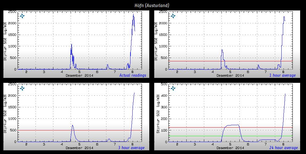
Looks like the gas is hanging around in Hofn today – posted from Twitter on Iceland Eruptions site minutes ago – levels of >2000ppb quoted earlier.
IMO can not fix GPS at least another few days. Problem – weather conditions.
https://www.facebook.com/Vedurstofan
Another Atlantic storm coming tonight
Courtesy of UKMO
And it’s quite a tough one. It is another of those big ones, sustained winds above 100km/h, and hurricane intensity is going to be reached in the north part of the storm, between the west fjords and Greenland.
Roads are already being closed in Iceland. There is heavy snow in many roads in Iceland, in some roads by the coast there will be heavy rain over the top of the snow and then freezing tomorrow, not nice. Inland, roads will surely be blocked by too much snow. Add the fierce winds later this evening, and again it’s one of those storms. I had to cancel a trip just because of it.
Badly affected will be also North Ireland and Scotland, and the Faroe Islands. But mostly likely only high winds and rain there.
Hi Irpsit
Knowing how you are a living library of Iceland’s eruptions, I was wondering what you thought of the red areas on this map (click on red/green thumb to see full size) and how it matches up to the most recent lava flows post glacier?
http://www.raunvis.hi.is/~geirf/seg/seg-ind.htm
yes,see :
http://earth.nullschool.net/#current/wind/surface/level/orthographic=-18.17,64.98,1462
Sincerely I do not hope that mcuh for monotoring the eruption other than the webcams.
It’s already hard enough to get to Valdalda during wintertime, getting to Bardarbunga top is just sort of insane thing to do in bad wintertime. It’s just blasting violent hurricane winds, together with snow/blizzard, together with severe cold, and add alsoocasional toxic gas pollution from Holuhraun and the danger of an unstable ice cap, whick cracks downwards every M5 earthquake.
It’s a dangerous spot to go!
High levels of SO2 are again recorded in east Iceland. Seems that… it’s back!
It happened also in 1st December. And now again. Seems that SO2 rich magma is coming back to the show again! This is far from over it seems…
I did actually wonder if there would be high levels in the east, even though the plume looked much thinner than at the start of the eruption, because the plume was very very steady towards the east all through the 4th, 5th and 6th.
At least it’s blowing the other way now.
Hello everyone! Just reporting for duty as junior Dragon lurker.I have been here quietly but my life has been somewhat chaotic .This is not conducive to deep rumination! Caring for elderly relative,Christmas preps,,daily chores,two dogs, on line course about the geophysical fun of eruptions and keeping husband fed and watered not to mention garden and allotment maintenancetakes up time. How did I ever find time to work? I
I hope all in Iceland and N
Northern GB ISLANDS STAY warm and safe.I am in thermal gear and recommend this to All in northern latitudes,.To he’ll with fashion and beauty. A woman never looks good if her feet are cold and painful ! our youngest dog is confused about the ice covering the decking every morning. At least this feels like proper winter and normal. Time to sort out evening meal BBL
Hello Diana,
The temperature is just about long johns/ taters/ brass monkeys here in Brighton; not proper northern cold, but fer us southerners… Bbbbrrr!!!
It’s nice to hear that yr well n’ busy
Please check the Den when you have some time x
Aaah, schteve42, you Brighton lot are such softies, it’s colder north of the South Downs 😉
Irpsit thanks so much for keeping us informed. Good luck with the storm and stay safe!
Storm is just arriving now. It’s going to be nasty blizzard in places. And heavy rain and very windy, thawing the deep snow, by the coast.
In the southwest of Iceland, worst of wind forecasted for 11pm and worst of snow/rain around 1am.
Storm conditions after 9pm.
A century history destroyed in Chã das Caldeiras in 15 days by lava on Fogo Island. The lava is unstoppable on Fogo Island, Cape Verde. The situation worsened and new locations will be evacuated in the coming hours, warned this afternoon Cape Verdean Prime Minister. In just 15 days the lava has already consumed two-thirds of Cha das Caldeiras and two of the main towns. (video) http://sicnoticias.sapo.pt/mundo/2014-12-08-Um-seculo-de-historia-de-Cha-de-Caldeira-destruido-em-15-dias-pela-lava-na-Ilha-do-Fogo
I have been watching some of the footage of the lava. So dreadful for the people, there is little land anyway, they cannot afford to lose the farmland and the buildings. Development takes a step back, and many will suffer for their losses.
Yes, and now Mosteiros, a 9.000 habitants city is in danger and on mandatory evacuation… this is sooo bad!
Hey folks, look at the webcam
http://www.livefromiceland.is/webcams/bardarbunga
Holuhraun looks, well, rather apocalyptic ! Very red and nice… amidst the upcoming storm…
Please, please send Screenshots!
Thx, Thx, Thx, Thx!!!!!!!!!!
There you go Susanna.
Thanks a lot!
Wow! Looks like there were visitors at Vadalda; headlights shining across the foreground for a couple of minutes. Unfortunately as I realised, they disappeared before I could get a screenshot.
New post is up! 🙂 Peru 2
https://volcanocafe.wordpress.com/2014/12/08/volcanoes-of-peru-2-nevado-sabancaya/
Done, Hope not too late!