
“As I have said so many times, God doesn’t play dice with the world.” — Einstein.
Since our last topic auto closed, this is provided as an interim post to keep the comments open for your use. Sorry if it seems a bit sparse. (GL)
As some of you know, I am a fan of Nicholas Taleb. He is the author of “The Black Swan: The Impact of the Highly Improbable” (2007). Mostly in jest, I have occasionally kicked around the idea of a ‘Black Swan Volcano,’ mainly from the point of view that in order to really ruin your day (on a humanity scale), it’s going to take more than a simple decline in solar activity to mess things up. All of the previous wild excursions in temperature, though they generally coincide with low solar activity, are punctuated by some sort of volcanic activity. The current decline in solar activity has been called out as very similar to the start of the Dalton minima and naturally, those that tend to do so, have been off beating on that drum. One can only guess at the level of noise that we would get if it were a Maunder Minimum scale event. Some solar physicists, such as Dr. Leif Svalgaard, think that the tally of sunspot activity is flawed and that the levels that denote “Grand Minima” or “Grand Maxima” are a bit skewed due to the criteria and methods that the official observers used when making the tallies. Even I.G. Usoskin (University of Oulu, Finland) has joined in on Dr. Svalgaard’s working groups that are trying to resolve those inaccuracies in order to get a research quality count. Usoskin is the primary author of “Grand minima and maxima of solar activity: New observational constraints” Usoskin et al (2007)
Okay, that’s a bit of background. You will likely get into a heated argument should you adopt the Grand Minima banner and start waving it about in peoples faces.
So, onward to that pet idea I’ve been kicking around. Unfortunate Coincidental Volcanoes popping up as ruiniers to an ordinarily pleasant climate. By Taleb’s definition of BlackSwans, you don’t see it coming. It’s buried in the statistical improbability and even if some wild arsed loon saw it coming, no one would believe them. The Stats would indicate otherwise.
Last Year, Kelud exploded, and did so in style. My initial interpretation of the VAAC reports were that it didn’t make it to the tropopause. It’s a safe assumption on my part since VAAC’s are mainly interested in keeping aircraft away from the plumes. They would most likely tend to over alert. It wasn’t until a couple of days later that someone posted a satellite view of the plume along with a LIDAR trace that showed that Kelud had easily made it to the stratosphere… that LIDAR trace even seemed to show that part of it reached as high as 30 km.

No matter how you look at it, that is way up there. Okay, so maybe Kelud is in the running for the mythical Black Swan status. It really depends on how much SO2 was lofted. I don’t have a really good way to estimate that, but I can show you a few other volcanoes and let you determine what could be coming done the pike.
Nasa keeps track of the stratospheric aerosol layer for their climate models. (the veracity of those models is left up to the reader). You can find ascii text data for the volcanic forcing of those models here. Taking that, and an output of VEI 4+ eruptions, you can get a view of some of the culprits.
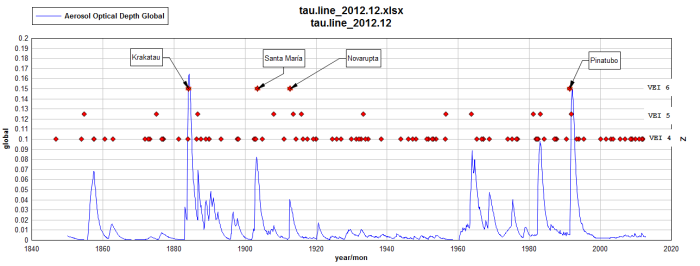
As you can see, the monster eruptions tend to have the most effect. But, notice how puny Novarupta is compared to Pinatubo and Krakatau. This is going to be due to where it erupted and what it erupted. At a higher latitude, Novarupta had easier access to the stratosphere, and all tropical systems tend to have a higher level of water vapor entrained into the column. (causes early leaching of SO2) This should work to Novarupta’s advantage. Yet it didn’t. Sulfur is the 16th most abundant element in Earth’s crust, being more prevalent than Chlorine (usually found in salt NaCl). As far as I know, how much sulfur was in Kelud’s column has yet to be published. But sulfur collecting is a pretty common way to augment income in some locales.


A friend in Hawai’i sends this link of a new lava breakout:
There is something utterly awesome and fascinating watching lava move.
So I wonder how many of us volcanoholics are also pyromaniacs? I sure am. My mother claimed the entire family were pyromaniacs. One of the highlights of her childhood was every year when her dad decided it was time to burn the pasture . . . somehow the fire always got away from them and a great deal of excitement was had before things were back under control.
Fire – Water – Earth, the three elements that have played key roles since the birth of mankind. I guess they are so deeply engrained in us that we have to stop and watch them in awe. I have yet to see the traveller who wouldn’t go out of their way to see a volcano, a waterfall, or a cave if they are reachable for them.
Thanks for the lovely video!
I do love a good bonfire and fireworks! And round here, bonfire societies thrive. Google Lewes bonfire night for details.
I used to want to be a pyrotechnician when I grew up. I’ve changed my mind.
Don’t get me wrong. I still want to be a pyrotechnician. It’s the growing-up I take issue with.
Well, former basket weaver Till Lindemann never lost his desire to be a pyrotechnician.
From the Wikki article: “An incident in September 1996 caused a section of the band’s set to burn, and as a result, Lindemann got his certification in pyrotechnics so the band could perform with pyrotechnics more safely than it had previously.”
😀 Huladancer
A slight tremoring at REN station.
Following on from Cbus05’s comment on the previous page and the uplift in +3m quakes in the last 24 hours, does anyone else think that we are possibly entering a new phase or the eruption? It does look like it to me – but I know nothing. 🙂
Not sure. But the board lit up quite well.
Notice that the line of quakes follows the track of the dike path. To me, this means one of two things. 1) A fresh pressurization of the system. or 2) the system is starting to shut down.
Given the projected end date that was promulgated by an IMO scientist recently, most likely option #2. This falls in line with the idea of the fissure slamming shut when the pressure needed to keep it open drops below a critical threshold.
The odd part is that magma pressure alone is not what started this event. Tectonic stress field changes lowering the strength of the fissure played a large role in allowing the magma to escape via this route. Another odd thing is that the mini quake swarm extends as far north as it does. I don’t know if this means that it did make it into the Askja system or not, but it seems that way.
I haven’t seen any plots recently of how the quakes are placed around the caldera. They’ve been seeming to be more distributed and going further south than they used to.
Yes, this could mean the final collapse … or something else.
There has been an uptick in quake activity in the dyke to the north, under Tungafell and also Bardarbunga, several times last weeks. I (and others) also noticed pretty high fountaining in the north side of the fissure; it was related by others to a possible extending fissure to the north. There also has been written about the declining magma ‘production’ at the south side of the erupting fissure.
Adding to Geolurkings comment, I think there are two groups of specialists, one that is relating the fissure eruption directly to the subsidense of the caldera floor in B (declining subsidense = declining eruption). The other group holds open the possibility that there are two events ongoing. The fissure eruption and the subsidense. Less connected.
The activity in B. on Tuesday until now (IMO source):
Tuesday20.01.2015 15:44:42 64.617 -17.417 1.4 km 4.1 99.0 5.9 km ESE of Bárðarbunga
Tuesday20.01.2015 14:17:17 64.601 -17.383 0.1 km 3.4 99.0 8.2 km ESE of Bárðarbunga
Tuesday20.01.2015 11:57:54 64.610 -17.385 1.2 km 4.4 99.0 7.6 km ESE of Bárðarbunga
Tuesday20.01.2015 11:22:54 64.601 -17.371 3.0 km 4.2 99.0 8.6 km ESE of Bárðarbunga
Tuesday20.01.2015 10:32:23 64.609 -17.430 3.0 km 4.7 99.0 5.8 km SE of Bárðarbunga
Tuesday20.01.2015 09:50:59 64.662 -17.428 3.1 km 3.9 99.0 5.3 km ENE of Bárðarbunga
Tuesday20.01.2015 09:45:55 64.655 -17.374 5.4 km 4.4 99.0 7.5 km ENE of Bárðarbunga
Tuesday20.01.2015 09:44:22 64.660 -17.361 4.7 km 3.6 99.0 8.2 km ENE of Bárðarbunga
Tuesday20.01.2015 08:22:10 64.666 -17.460 2.5 km 3.3 99.0 4.3 km NE of Bárðarbunga
Tuesday20.01.2015 07:32:21 64.666 -17.422 6.8 km 4.0 99.0 5.8 km ENE of Bárðarbunga
Tuesday20.01.2015 05:51:25 64.665 -17.369 2.8 km 3.3 99.0 8.1 km ENE of Bárðarbunga
Tuesday20.01.2015 05:30:40 64.676 -17.427 8.4 km 3.2 99.0 6.2 km NE of Bárðarbunga
Tuesday20.01.2015 03:57:38 64.679 -17.428 6.2 km 3.4 99.0 6.4 km NE of Bárðarbunga
Tuesday20.01.2015 03:54:26 64.666 -17.455 6.7 km 4.1 99.0 4.5 km NE of Bárðarbunga
Tuesday20.01.2015 01:30:20 64.671 -17.470 4.1 km 4.0 99.0 4.3 km NE of Bárðarbunga
Tuesday20.01.2015 01:29:13 64.673 -17.393 7.4 km 3.9 99.0 7.4 km ENE of Bárðarbunga
Tuesday20.01.2015 01:26:55 64.674 -17.447 9.2 km 3.4 99.0 5.4 km NE of Bárðarbunga
I think it’s worth noting that there have been a lot more scattered earthquakes outside the caldera itself and the primary dike in the last 1-2 days. There was a small quake swarm at Gjalp, the deep quakes in Askja Central, Tungnafellsjokull has been more active than ever recently.
On top of that, the overall earthquake energy has been on a slight incline recently, both in the caldera, as well as in the dike.
Not sure it’s closing time quite yet here.
Also quake activity in Kistufell and the other random quakes that popped up earlier (torfajokull swarm).
The dyke wouldn’t have made it into Askja. The magma effectively flowed down hill all the way. That is the reason for the route it took, including the sharp bend when it reached the rift. It erupted at the lowest point were it could. To go further in the same direction would require going against the gradient. It can affect Askja indirectly (providing heat) but if it connects to the Askja system itself, Askja magma would flow out rather than Barda magma in.
Well the cloud of vapour looks thicker than it did all day, but that is probably just because it is being bottom lit.

Although I suppose it could be fresher lava arriving.
I am sure I am not the only one who finds the lack of cameras closer to the lava flow frustrating, especially when the steam plumes are being illuminated as they are to night, hopefully the failed cams/data links will be replaced soon.
An update to the lava flow map would also be good, 10 days now, since the last one.
Image cropped this time

Source IMO and weerstationlangerak.nl
Dyn Tremor is showing periodically rising red tremor line since the end of december. I learned here on VC, that this line represents magma movement. If I’m I right?
If so, what could this imply for Bardarbunga? Magma leaving or magma rising? Or…non of the above.?
With no expertise whatsoever, I’d say that Barda still has some tricks up his sleeve in the near future. Especially because everything along the MAR in Iceland has been sort of active since the start of the new year.
Since september 2024, a couple of times a day I take screenshots from the “quakes in the whole country during the last 48 hours. I’m making an animation of it and it shows an interesting pattern. Specifically, the quakes along the MAR.
Does anyone know if we entered a new period of rifting since the end of december?
Looking forward to the new measurements of the lavafield and the rescue mission of the caldera-GPS.
An interesting report,
comparison with earlier outbreaks have is amazing
http://thewatchers.adorraeli.com/2015/01/20/holuhraun-eruption-update-iceland-s-largest-lava-field-since-the-laki-eruption-in-1783-84/
Thanks for posting, that’s a great article, incl map and photos too.
Thetsunami, the rifting in the B area is not much now. http://hraun.vedur.is/ja/Bardarb/GPS/Slider/images.html
I like to play with the dates, to see how the as dots presented quake pattern is changing. Indeed near Aksja the pattern is evolving interesting.
Could you post the animation you made please? 🙂
With pleasure Rob. I’ll post it as soon as I can. It’s still WIP.
OT
Recently , I guess, the blogsite has been upgraded to https mode. Eversince I get messages this pages contains unsave contents (yellow lock….)?? Is that me only receiving this message?
I’m not seeing that – I do have adblocker on though.
Nothing on IOS here.
somewhat off topic http://uk.reuters.com/article/2015/01/20/us-science-scrolls-idUKKBN0KT2IW20150120
Vesuvius-scorched scrolls may be readable
The Local (Italy), published: 20 Jan 2015 17:30 GMT+01:00
Precious scrolls blackened by the eruption of the Vesuvius volcano in AD 79 may become readable again, thanks to 21st century technology, scientists said on Tuesday. …
http://www.thelocal.it/20150120/vesuvius-scorched-scrolls-may-be-read-again
Wow, if this pans out it would mean a lot of work for the experts of ancient philology and history, and hopefully new insights for us as well!
This method of reading the scrolls has been talked about for over three years. I’m glad it has come up again, because they really need to get off their rear ends and get on with it! The Villa Papyrii has only been partially excavated, two thirds remains hidden and it is chock full of these scrolls. Sadly the Italian Government is in a right state and will not attend to this whole issue. Meanwhile, Vesuvius ticks away and who knows, could destroy everything again.
Needless to say, it is a pet irritation of mine! Sorry to rant…
My goodness! I have just read up on this….What a difficult project…. from this
http://www.classics.ucla.edu/index.php/pages/83-herculaneum-papyri-before-unrolling
to this……..
Click to access JankoRecentDevelopments.pdf
And we don’t get a second shot at the Library of Alexandria since the people that torched it made sure that nothing was recoverable.
Its a really major library owned by a major statesman (see wiki).
Lucius Calpurnius Piso Caesoninus (c. 100 BC – 43 BC) was a Roman statesman and the father-in-law of Julius Caesar through his daughter Calpurnia Pisonis.
He is believed to have been the owner of the Villa of the Papyri at Herculaneum.
Considering the vast amount of papyri in that one villa, and the small amount of Roman and Greek writings that have come down to us, any one of those scrolls could open up whole new windows on Roman knowledge and thinking. I hope they can read them – it would be very exciting!
Hi all, I haven’t been following at a detailed level and was wondering if someone could help me to understand … This one looks relatively deep, how often are we getting these deep ones? Thanks!
Tuesday
20.01.2015 21:03:19 64.730 -17.491 23.0 km 1.3 99.0 10.2 km N of Bárðarbunga
Good Evening all 🙂
Thank you Lurking for that link to the pooping dogs paper. Fascinating stuff that raises some deep thoughts.
Here are but a few. Pooping alignment. Now does the Earth’s magnetic field have an effect? Really?
Poppy and Max (RIP) both large. Both Clumsy with little finesse walk in a circle and deposit large ,decidedly fragrant, elephantine heaps in various alignments. I have a strong suspicion it may be something to do with the prevailing wind direction in order not to be gassed by said Doggy fragrant odour (Stench).
Oggy (RIP) like your dog sought shelter/privacy/safety beneath bushes and in corners. No special alignment. He was prone to doggy crises and hated changes in routine etc.
Meg cannot deposit unless walking. This is a nuisance as it complicates the poop scooping ritual. it also means again no special alignment.
So….
end of deep thought one.
Deep thought 2.
Wild V domesticated. Would this have an effect if the animals were affected by magnetism?
Deep thought 3
As humans are also animals we too should be affected subliminally by the earth’s magnetic field.
Which way would we face if left alone on a desert Island?
Deep thought 4.
Drinking, birthing and defecation are animal activities where some animals are most vulnerable. I think keeping an eye open for danger would play more part of alignment than magnetism.
Deep thought 5……..
and the application of the results are ?
<<<<<< Straps magnet to Doggy Bums, . Places strong magnet in shallow ,poly bag lined receptacle……..Solves .problem of poop scooping in snowy conditions (Where poop can be hidden until squidged underfoot)…Hey presto! Doggy bum aligned over easy to collect poop container. 😀 😀
…And now something completely serious and ON topic and may have a profound effect on the behaviours of many animals and throws new questions into the accepted faces of geophysics.
http://sciencenotes.ucsc.edu/9501/Mountain.html
Wouldn’t that be ‘accepted faeces of geophysics’?
Oh sorry, I think I replied to the wrong post.
🙂
Congratulations on passing your exam Diana! 😀 I was going to sign up for it but was put off by the chemistry/ maths stuff. I’ll wait till I retire before I start any online courses – much too stressful to do alongside a full time job and long commute.
Dog poo I do know about – none of my dogs (I’m on no. 4 now – see pic left of my name) has ever shown a particular preference for alignment but two always had to go in long grass or an out-of-the-way area and two don’t/didn’t care. Interestingly (or not) the two ‘shy’ ones were dogs and the exhibitionists are/were bitches. I’d agree that a sense of survival over rides any idea of lining up to magnetic lines. Does lining up to face south serve any evolutionary purpose? Can’t think of one. But hiding away in the long grass when vulnerable makes sense. Bitches tend to stay with the pack so would be protected by the others – but young wolves (ancestral dogs) go off alone to start new packs so would have no pack protection.
Thank you Talla . Yes there is a real plus side to retirement. Time to be totally selfish and indulge in learning New tricks for old dogs 🙂
Having said that I have found I seem to have less time than I did when I was working. How did I ever manage to hold down a job, raise a family and run a household?
I no longer have the kids or a job but I seem to have less time to keep the house in order. There again if I analyse my activities I am still “working”. Hours spent selling my collected “stuff” on ebay to augment my lack of pension money. Hours spent on line mostly following Volcanic activity, growing vegetables on an allotment ,again to ease the financial burden of old age and also to keep fit (ish). However, I am lucky, my life is still fun and I wouldn’t have it any other way. 🙂
I envy you! But I’m hoping to have enough saved so I can retire this autumn. Then I’ll set about selling/ giving away / otherwise disposing of my ‘stuff’. I also have to get the house and garden looking smart with a view to selling. My dream is to move to somewhere small in the Highlands but a long way to go on that! Then there’s all those languages to learn and books to read and I’ve always wanted to do more tapestry and learn about plants and the names of the stars etc. etc. etc. 😀
Well, I have to admit that I have done some rumination on the canine alignment thing. How was the observation made? Would a more fine grain analysis be better if they could attach archiving bearing sensors to the critters? How do you tell when the dog “assumes the position?” At one time I attached my accelerometer to the dog just to see what sort of data stream I could get. As expected, the g forces were all over the place in the x-y-z axis as the dog ran around the yard. Using a harness and attaching it dorsally would probably be better than on the collar.
So what if you find that all dogs in a region shift to a different alignment in unison? A localized Geomagnetic Excursion?
Now that would be ominous.
GL,,,the dorsal thing is a great idea….and… it can be fashionable as well! Oh….and it could be used for feline data too.
[IMG]http://i59.tinypic.com/10wtw86.jpg[/IMG]
[IMG]http://i58.tinypic.com/64h2tt.jpg[/IMG]
oops! forgot to remove the IMG from the code….here they are


And the oddities of late night TV Advertisements.
Saw one that featured a harness like assembly that you could fit a disposable catch bag to. The idea was that you just corner your dog later and replace the bag. The amazing part was that the dogs didn’t seem alarmed by the added appendage.
And tonight, I picked up another large bone for the large dog. It wasn’t as huge at the normal bovie femur, and the bugger literally ate the whole thing inside of 20 minutes.
Hi Diane: congratulations with passing the exam,and with a very good score! Old dogs can learn new tricks! Sorry – 18-yr old dogs can learn new tricks. I find this kind of physics difficult too. Too many parameters. Light and gravity are much easier.
Thank you Albert 🙂 A quick rumination here after reading Lurking’s post above and now yours about old dogs 😀
I had this vision of Lurking’s poor pooches. They must be very tolerant and long suffering 😀 Combine the older dogs with gravity and light experiments and you get a new take on The Dog star. New astral bodies that “assume the position” and produce an alternative to “The big bang” theory 😀
Funnily enough I was contemplating this course next as I have bits of knowledge and really I should link them together in a more logical sequence. This course looks like it will help me organise my understanding and also increase it. However I shall have to wait until the course repeats at a later date. as it’s half way through at the moment.
https://www.coursera.org/course/introastro
This could be good. It covers a vast range of topics and this may make it feel like you jumping from one thing to the next. But it does seem to cover the main areas. In your neck of the woods, UCLAN offers distance learning modules in astronomy and the OU has courses both in astronomy and in planetary sciences. I am considering taking up a request to write a book on the physics of the solar system – but it is probably too much work for too little audience!
Morning folks,

A bright sunny day at Nornahraun, with an apparently very reduced plume of gas from the eruption.
Great pic. Thanks. Is that Tunga on the far right and Barda in the middle?
Hi Tsunami,
This is looking N from Kverkfjoll, with Herdubried extreme right above Vadalda.
Askja in the middle
Thank you!
Visitors

I saw them, I need to leave but this sunset is stunning, I have fog, waiting for rain (again)
And a jet :D, beautiful
Look at the magma movement after the M4.5 at 15:44. (no expert)
Hi all, here’s a new timelapse from Bardarbunga covering the 20th to 21st.
A silent version can be found here http://youtu.be/sQhAs7RpEQA (in case the video is blocked)
The one with music has music composed by Gustav Holst: Neptune, The Mystic, performed by the Berliner Philharmoniker and conducted by Herbert von Karajan.
(Unfortunately I had not enough material to use it entirely)
Thank you so much fkavirtual. Even my husband was impressed as he stopped to watch it on his way to bed. He’s just had laser treatment on his back and is in some discomfort but this stopped him in his tracks. It shows the creation of clouds so well.
Husband suggested it would be good for roasting potatoes in their jackets 😀 😀 He also commented that there is so much heat/energy going to waste!
How to harness a volcano?
My husband isn’t often so enthusiastic about volcanoes so well done!
That is absolutely beautiful.
Perfect choice of music!
Aside from the beauty of it, I noticed a couple of things: the intensity seemed constant – not pulsing… and the nearby activity must be getting close to the river junction. Wish the MOGT cameras were working.
I had to wait until I had time to reboot to get my sound back, is that you best work yet, super nice, Thanks!
Beautiful thanks…. Holtz fan myself..
Yes, wonderful indeed.
It seems to me that we can more clearly see three areas — would-be fountains? — certainly in Cam2, but by the end we could also see it in Cam1. (Maybe earlier, I didn’t rewind to look.)
This tickled the fancy of my muse:
Three trolls live inside.
By day they must – they need — to hide.
At night they rise above the plain
And play, ’til it is day again.
I was just thinking earlier today how funny it is thinking about how Katla was predicted 5 years ago. Instead we have had Grimsvotn and Bardabunga.
Who will be next?
Wishful thinking… but if I say which one it is I will be labeled a cruel and heartless person. Even if it just had a seismic crisis people would flee in terror.
oh go ahead G.L
“Wouldn’t be prudent”
Stop being such a tease GL….I MUST know now 😦
Disclaimer: I have no credentials that lend credence to the veracity of my hypothesis. I’m a know-nothing wannabe. OK?
I usually look at this picture close-up, like on Baering. Usually I feel that the EQs around Tungna look like they are being caused by magma moving out from Bard. But looking at today’s EQs from further out, don’t they look like they are on the same line as the path the magma originally went — back on Aug 17 – 20 — when it came out from Bard before it took that left-hand turn?

Y’wanna know what I think? I think that line is created by the edge of the Hreppar plate, and that the EQs are driven by tectonics.
And that would mean that it is possible that the fat lady’s limo hasn’t even arrived yet.
Either that or God has placed a check-mark over Iceland in approval.
No more out there than any of my ruminations. Thanks for the input!
However, if it is the corner of a microplate, as you have noted… it would be the Tröllaskagi micro-plate. Its a less well accepted structure than Hreppar, and lies to the North and East of it. The western boundary is not well established, but the southern and eastern boundaries are… and follow the track of the MAR. That is, if it is real and not just an odd appendage of the North American Plate, to which it would be pretty much completely sutured to by now. Much the same way that the Jan Mayen microcontinent is a physical part of the Eurasian plate after the Aegir Rise became quiet.
LOL That definitely is a check mark. 😀
oh separation within the one language meant it took me 3 reads to understand that, yes I can see a ‘tick’
A tick: something that gnaws away at you, makes you itch, usually goes away but sometimes causes really serious health problems.
Check: like someone’s saying, OK, now get out of that you b*****d, or you’re dead.
Also can be indicative of a turn in something that is linear, like a fence. More of an informal way of pointing it out. Or, an involutary muscle movement, as in a facial tick,
A check could also be one hokey player blocking another, or an order from a line supervisor for the handlers to stop the line from moving. As in “Check Line 5.” Only after the mooring operation is done would they then frap the lines and install the rat guards.
The metal cone on the mooring line is the rat guard, not the sailor.
Some of that’s a bit too cryptic for me, I’m afraid… “rat guards”?!
Devices attached to mooring lines to keep rats from surreptitiously accessing the ship. They will have to proceed to the brow/accom ladder and present valid ID and request to come aboard just like everyone else.
I was hoping that the picture would clarify what I was talking about.
BTW: Some ports have a pretty difficult rat population. Some even appear to do weight training based on their massive size.
Ah. Yes, I saw that and made the correct inference from the picture.
I was meaning to imply (slightly cryptically) something about the state of BB by my comments about “ticks” and “checks”, and I thought you were answering in kind. So I was looking for ambiguities in “rat guards” that could be taken to apply to BB…
LOL Check mark to us is having a list of items or chores to do, then put a check or check mark after it when done. It’s shaped like on the picture above. A tick here is a parasite that sucks blood off of animals or people. A tic is an involuntary muscle movement usually of the face. I just love how we can learn from each other and how amusing it can be sometimes. 🙂
Never encountered a chigger eh?
Not quite a tick, but a parasite in it’s own right. Guaranteed to make you very unhappy. It likes the warm dark recesses of underwear.
Dunno about the acceptability of the practice, but when you find a tick on your horse, heat up it’s back end (the tick, not the horse) with a cigarette and it will release it’s bite. Removing it otherwise may make the head snap off and leave a wound much more prone to infection.
Here in Indiana chiggers tend to cause something like a large mosquito bite if you sit on the grass in the evening. Which could be anywhere your bare skin touches the grass. I learned that when I was a youngster. 🙂 I had horses but on the few occasions when they got a tick I very carefully removed them.
Mila1 just zoomed in I wonder if the operator is trying to spot activity on the edge of the glacier
More activity in the dike this morning.

The longer this goes on, the less it seems like Lurking’s “dike slamming shut” theory (which is a strong possibility still). The heightened activity in areas outside the dike points towards a bit of a rejuvenation of the system (albeit still not like it was at the start).
Two prongs of a triple junction?
I was thinking that too. oh and hi all
Its me, Jamison in Iceland
OH Hi There Jamison 🙂 I was wondering what had happened to you 🙂 Are you still doing shift work? Belated happy new year 🙂 I hope all is well with you.
That “slamming shut” idea is not my own. It was based on a paper that I read that was going through the physics of caldera collapse. It was part of the logical train of thought explaining the formation of a dike. When the chamber pressure climbs above the tensile strength of the chamber (typically at the top of the chamber since the lithostatic stress is lowest there and the ability to withstand the hoopstress is lowest. The rest of the logic train followed that the dike could and would propagate until the chamber pressure of the magmatic system (which includes the dike volume) drops below that needed to keep the system open.
In the Bardabunga instance that we have going on now, it’s not really a matter of the chamber pressure growing larger than the hoopstress toughness of the rock, the prevailing tectonic forces weakened the rock and the already pressurized chamber merely took advantage of the new weak zone and propegated a dike.
Albert’s take on it essentially being “down hill” flow keeping Holuhraun active, is probably the best mental model of the current situation. In my opinion.
The issue with the quakes up around and north of Askja are likely more an indication of the regional tectonic setting than the finger of magma having traversed the chamber. I don’t know the system well, but one would think that Askja would not take lightly to a stray dike from Bardabunga wandering through it’s inner recesses. And so far, Askja hasn’t seemed to notice this stray dike tickling the outer fringes of it’s petticoat.
Oh my! **fans self** You may have started a new genre of literature GL….”Volcanic Erotica” 😉
Hi folks, MOGT cams on Vadalda are back up


Looks like they were just testing, two refreshes and stopped again
Hekla, Earthquake a tiny distance SE of volcano .
OT but when was the last earthquake over 7.0M? Don’t remember one for a while (but that could be my faulty memory).
Hi Karen,
Magnitude Mw 7.1
Region MOLUCCA SEA
Date time 2014-11-15 02:31:43.1 UTC
Location 1.93 N ; 126.52 E
Depth 51 km
(EMSC) 🙂
Thank you, Granyia.
Evening all! OT as well, today seems a good night for Aurora Borealis, I hope it stays for a while 🙂 Abisko, northern Sweden:

from: http://www.auroraskystation.se/live/
I should have waited a moment, it’s getting ever more pretty!
We had a lot of luck on Venus
We always had a ball on Mars
Meeting all the groovey people
We’ve rocked the Milky Way so far
We danced around the Borealis
We’re space truckin’ round the the stars
Come on let’s go Space Truckin’
Ah Deep Purple. I like Smoke on the Water.
I never operate a vehicle impaired. 😀
“Speed King” is one of my favorites… as well as “Lazy”.
And a completely different colour: Klyuchevsky this morning, an artist couldn’t have done it any more artistic!

Cropped and added contrast, from http://www.emsd.ru/video/
Stunning photos, both of them!
I feel a song coming on….
Red and yellow and pink and green
Orange and purple and blue…..
I can sing a rainbow…. 😀 😀
Thank you for those beautiful photos Granyia. Magnificent colours.
Thanks… but I’ll stick with Deep Purple for now… 😀
LOL 😀 Husband does say I sing like a frog 😀 However Kermit made it big time 😀 😀
I feel a Rainbow rising… on the horizon….
oooh! aahhhh!
Mt. Rainier, this morning

Wow, the day of the great colours! That’s one for Lurking, Deep Purple!
With thanks to British Pathe web site I found a very early silent movie clip of Vesuvius 1929 eruption. A useful website for Historical info.
http://www.britishpathe.com/video/vesvius-vesuvius-in-eruption-again/query/vesuvius+eruption
I wonder if Vesuvius would do a similar event today, how would it affect Naples..
Yow! that was some film. too close IMHO, it is a wonder that the film crew wasn’t gassed! I’ve been close enough
to St Helens, but at least I was in a hot rod Cessna 320.
foot, donkey, or even Fiat would not be fast enough….
Check out this bad boy:
Friday
23.01.2015 06:20:40 42.2 km 1.8 59.0 14.0 km SE of Laugafell
Interesting one. How thick is the crust reckoned to be here? If I’ve understood things correctly, this is in the transform zone between the WVZ and the EVZ/NVZ.
Can anyone explain what all this might signify – assuming I’ve got the basics right?!
Running on minimal coffee at the moment, but if it’s where I think it is, it signifies stress moving along the usual weak points in the fault zones. Lacking a beach ball to see the focal mechanism, that’s about all I can muster. Logically, the stress field should eventually be manifest on the other sections of the interface of the two major plates.
I failed to spot that the quality was only 59.0%. They’ve changed it now:
23.01.2015 – 06:20:44 – 64.715 – -17.879 – 6.7 km – 1.1 – 99.0 – 9.3 km E of Nýidalur
Sakurajima can not sleep 🙂
… Klyuchevskoy also
ATM we are not seeing the option of full screen in mila 1 and 2 camera sites, does anyone else have this problem?
Hello Biologique,
Are you talking about the Full screen / Minimize button that normally shows in the top right of the screen?
If so it may still be there, but hidden, try moving your mouse pointer over that area it may reappear
Thanks Colin, actually I did try that. Noticed early in week that sometimes the option did not show.
Hi
new pics of nishino shima
http://www1.kaiho.mlit.go.jp/GIJUTSUKOKUSAI/kaiikiDB/kaiyo18-2.htm
From this paper
Propagation, linkage, and interaction of caldera ring-faults: comparison between analogue experiments and caldera collapse at Miyakejima, Japan, in 2000
Steffi Burchardt, Thomas R. Walter
http://link.springer.com/article/10.1007%2Fs00445-009-0321-7
There was a pattern of quakes that increased in magnitude and went from deep to shallow as the caldera collapsed according to the study.
If you look at the plots of BB caldera quakes you can see that this pattern has happened a number of times over the weeks, quakes going from deep to shallow and lower magnitude up to higher
I believe this is related to how the chamber roof is collapsing as the pressure drops and this causes an upward cascade of quakes from deep towards the surface.
The pattern is now in a deep phase but also in a waning phase in total as this eruption seems to be winding down.
Although there is an uptick in frequency of quakes in the last few days the overall energy in the caldera is slowing winding down
Her are my up-to-date plots. The number of earthquakes fluctuates but the energy in them goes down. The fit is the same exponential as the deflation. The energy has declined a bit faster than this. I agree with the pater of upward moving sequences. If you look at average depth, initially the shallower were stronger (you can see that because the blue line (weighted by energy) is less deep than the red (total number of quakes). That difference has gone away: the shallow earthquakes have gone down in strength by a lot.
Speaking of quakes local quake right on the Olympic
Wallowa lineament. 3.0+:
http://pnsn.org/event/60949862#overview
Things are a bit active in the US NW…..
It does seem like the current caldera subsedience episode in BB and its related seismic events is nearing its end. It will be interesting to see what happens with Nornahraun when the system reaches equilibrium, which according to your graph should happen in march or april. If does have its own supply from depth, it may continue nonetheless. The net flow out of it seems to correspond quite nicely with the displaced volume of the caldera + the volume of the dyke, right down to the estimated m^3/s of the caldera drop vs the lava flow of the eruption. That suggest that these are linked, and if so, Nornahraun should stop as well when the BB drop stops. Interesting months ahead 🙂
Are these local quakes real ones or are they caused by fracking?
I don’t know of anyone fracking in the Bardabunga area. Hengill, yes, they are quite upfront about doing well injection experiments. One such test used a propping agent that would form grains of sediment as the material reacted with the hot rock. I find the Hengill injections to be a bit alarming since when they do that, the whole area lights up with tiny quakes. That Hengill is over a triple junction is a separate matter.
I was thinking off tgmccoy ‘s comment, But I should have read it better – it is the USNE NW, not NE. The NW is not obvious fracking geology.
Well, it’s not “North” but The Geysers geothermal plant does injection from time to time with the accompanying flurry of mini-quakes. It’s not on a triple junction, but the Mendocino triple junction is not really that far away. (225 km) 😀 Hengill is slap dab on top of one.
Oh, and technically I was just “yanking your chain.”
No fracking in Washington, yet.
Stunning timelapse of Colima in the papers; pyroclastic flows and all!
http://www.independent.co.uk/news/world/americas/amazing-timelapse-of-mexican-volcano-erupting-9997616.html
Okay, no “r”, you’re not the guy that plays “Worf.” 😀
Great imagery of the formation of Colima’s 4000 meter plume.
I was just thinking, We know that Fissures are the way that Magma is transported to the volcanoes. Now I’m wondering at how, were, why the magma goes to a specific volcano.
“…no matter where you go, there you are.”
— Buckaroo Banzai
I believe that it’s a combination of where the melt forms, and the density/shape of the overlying rock structure. In a “plastic” environment, Rayleigh–Taylor instability probably dictates how it initially moves.
As I understand the opinions of others, Holuhraun (or what ever you call the eruption), is not a volcano. Bardarbunga is the volcano and this what volcanoes sometimes do when covered with a kilometer of ice. especially when there are plates moving in a manner that causes gaps.
Thats about the gist of it. The really , REALLY astounding bit, is that the dike from Bardabunga crossed into another volcanic system, then traveled out to a third system before broaching the surface. As far as I know, this is the first time that anything like this has been actually observed and recorded. On thing that comes from this, is why did it turn to the North? Did it experience the already pressurized system of Grimsvotn? Or was it just weaker to the North from the ongoing tectonic stress changes?
Before this, the general mantra was that one volcano will not “link” to another volcano. One such link that has long been bandied about, was the supposed link with Katla and her neighbor. Nothing turned up as evidence of that even when Eyjafjallajökull popped the cork. “Katlas gonna go! Katla’s gonna go because it always does.” or something to that effect was heard quite a bit. The dirty little secret is that whenever Eyjafjallajökull erupts, Katla has either just finished erupting, or is well on it’s way to the next one whenever Eyjaf does it’s thing. You can see this just from looking at the eruptive years. Katla is like a scheduled bus stop compared to Eyjaf. If you walk out your door and a bus pulls up, it’s not because you came outside, the bus was already going to pull up whether you were there or not.
Holuhraun throws that to the wind and demonstrates that not only is it possible for one volcano to meddle with another ones piping system, it has been shown to actually happen. However, in this case, it’s sort of cheating, since the whole shebang was made possible by tectonic stress field changes. I think that had this not have happened, Bardabunga would have just muddled along slowly inflating until it was ready to have a central crater/caldera eruption.
In actuality, Holuhraun is the second time that Bardabunga has tresspassed into the Grimsvotn fissure swarm. Gjalp was the other time, though it generally is attributed to Grimsvotn. Gjalp was preceded by that odd “Non double couple” event at Bardabunga which some researchers have equated to “no net displacement” in the magma chambers/caldera floor.
“The Puzzle of the 1996 Bárdarbunga, Iceland, Earthquake: No Volumetric
Component in the Source Mechanism” Tkalčić et al (2009)
Bulletin of the Seismological Society of America, Vol. 99, No. 5, pp. 3077 – 3085, October 2009, doi: 10.1785/0120080361
For them that forgot or didn’t happen to know.
When an earthquake occurs, seismologists can look at the “first motions” of the seismic wave and determine if the seismo is in a compressive or extensional quadrant of the earthquake. By plotting out these first motions from seismos at different locations around the quake, they can determine with pretty good accuracy what the failure mechanism was. Normal faulting, Reverse faulting, etc. In an explosion, such as a nuclear device, all quadrants would show a compression mechanism.
Just from fiddling around in the backyard, I think that an impact would show extension in all quadrants. I used an accelerometer and batteries dropped at measured distances and angles from the accelerometer. Keep in mind that I could be wrong, I was just some redneck tossing batteries around in the yard. (because they were heavy from having lead plates and I could control whether they hit flat or corner first on the surface)
The answer is probably far more technical than I can understand, but I need to ask:
How is it *known* that the magma has moved through 3 systems? Couldn’t it be traveling in dykes parallel to those of the other systems?
Conversely, in a place like Iceland, why would it be assumed that there *wasn’t* communication between the volcanoes? (Was the “no crossover” theory based on observations of volcanoes that are more easily placed into pigeonholes?)
Lastly, if it is argued that the the vent creating Nornahraun is not a volcano because it does not have its own magma source, how can the existence of a single line mantle -> chamber -> volcano be proven in all cases of things called volcanoes?
Well, now you have broached an entire “philosophy” issue. Mainly because it deals with interpretation of what is seen and mapped. Volcanoes have radial fissures. These generally point towards the central uplift region that overlies the magma chamber. Most volcanoes have this sort of feature. In Iceland, there are other fissures that are equated with a central volcano that seems to be at the heart of where these fissure “swarms” track through. Usually, you find the central volcano and it’s radial fissures sitting in the middle of the widest part of this regional fissure system. They make up the fissure swarm. Many of these swarms have been mapped out in the past and the volcanoes that they are associated with are known. The intrusion from one system from another is known by IMO’s tracking of the dike as it made it’s way to where it is. There has been at least one paper produced that identifies this action. That’s the one that the dragons went freekazoid over when the direct link to it was placed out in the open. We didn’t want to be party to anything that circumvented the ownership rights of that paper. That’s bad form no matter how you look at it. But in that paper, they discussed the tensile field that opened up one of these regional fissures and allowed the magma to take advantage of it as it moved from the radial fissures to the regional fissures. What was surprising to me, is that it crossed over into the swarm typically associated with Grimsvotn. Then when it got into the Grimsvotn regional swam proper (pretty much into the middle) it took a hard left turn and headed off towards the regional swarm for Askja.
Side note: Regional swarms tend to follow the lay of the MAR, though they seem most associated with a dominant central volcano. Daughter systems are out there also, with systems like Hamarinn (Loki-Fögrufjöll) to be a subfeature of Bardabunga, or Thordahyrna to be a subfeature of Grimsvotn.
The yellow regions are mapped out fissure swarms.
More info can be found at Dr. Tobias Weisenberger’s site. (Figure 4 on that site gives you a good representation of the crustal thickness there based on seismic data. Figure 6 is a good simplified isotherm cross section of a typical rift section and fits quite well with what I found out writing “The Dead Zone” article a while back. Remember that at about 800°C the rock is begining to become quite malleable and stretchy.)
If magma is rising from a hotspot near both Bardarbunga and Grimsvotn, rather than from directly beneath Bardarbunga, the apparent left turn becomes easier to explain.
The left turn can be explained (in fact could have been predicted) by considering the energy needed to push the dyke ahead. This is a combination of the stress in the rocks and the weight of the rocks above (which need lifting when you insert magma). Close to Bardarbunga, the excess stress from the magma reservoir made the dyke move directly away from the caldera. According to the nature paper, this was pretty close to the most favourable direction. (It could have gone a little further south). Once it reached the saddle between the two volcanoes, going on was not a good idea (against the stress of Grimsvjotn and the push from behind from Bardabunga had run out at this point). So it followed a direction where the topography (rocks plus ice) was lower. The models can even explain the two later changes of direction. Once it had left the glacier, the area was pretty flat and it just followed the MAR as far as it could. That direction took less energy than any other, as the stress was lower along the MAR.
It was a bit more favourable to turn north but it cold have gone south as well. If the first dyke had taken a more southerly route, it would probably have gone south along the MAR.
Hi all, here’s a new timelapse from Bardarbunga covering the entire 22nd of January, starting at midnight (Amsterdam time, GMT+1)
A silent version can be found here http://youtu.be/KCGDsG9Y0uI (in case the video would be blocked)
It is a stunning display of color again.
The one with music has music from This Mortal Coil – Ivy and Neet
Super! Love the roll cloud formation about 4 min into film and low sun images plus crescent moon setting. Thanks.
Real nice. 🙂
well, I think you outdone yourself this time 😀
Solved the problem of no full screen option on Mila 1 and 2 cameras. When ad-block on no full screen option. Turn off ad-block and option reappears, after refreshing of course. So now have to make a decision each time whether or not to remove annoying ads with add-block. (:-( Of course one can always close add on site.
Saturday
24.01.2015 07:25:48 64.668 -17.483 7.0 km 4.9 99.0 3.7 km NE of Bárðarbunga
Source: IMO
M 4.9
Yep, this event is definitely declining…
Well, there hasn’t been a M5+ for weeks now so yes, it is indeed declinging (though not stopping yet, obviously). I wonder if we’ll start to see more “dike collapse” seismic events in the dyke itself as the pressure in BB nears equilibrium in a month or two. Perhaps might even repressurise parts of it again (due to some parts partly collapsing) and make it extend elsewhere before it it finished.
Has there been any event in recorded volcanology, where such an amount and frequency of M5+ quakes have taken place as with Bardarbunga?
According to the old reports, Krakatoa had numerous heavy quakes in the years before it erupted, and also during the eruption which lasted a couple of months. Laki also had a lot of quakes. An emptying chamber can give much heavier quakes than an inflating one, and I find it tempting to assign both these quakes to such a source. Carl thought that the quakes came from Laki itself, but I don’t think we know that.
The quakes this morning followed a nice Ian-sequence: 9.6, 9.4 and 7km in depth, with the last one being the 4.9
Laki was supposed to have produced many eqs in the months prior to eruption. BTW Grimsvotn also erupted during Laki’s eruption.
Thanks for that info.
Do uou know if these events have been properly documented by volcanologists?
“We’re not in Kansas anymore”, is a phrase I’ve read many times here.
Maybe, because of the absurd amount of M5+ quakes at the start of the event has changed the rules e.g. the reliabilty of distinguising rising magma?
Many of the measuring equipment we could read of at the start of the event have shut down during the course of this eruption.
I’m not suggesting that there is magma on the rise. I’m just wondering if there’s enough real time data at this moment to exclude the possibility of the “magma filling the cracks” scenario.
It sounds plausible in my layman’s ears.
I doubt it. Volcanolgy was not a science then but there are contemparary reports.
In one account of the Laki run up and start, there are mentions made of quake effects at distant villages. “pots swaying, furniture hopping around, hard to walk” and such. Taking some of those descriptions, and finding the appropriate MMI that describes the effect, you can then “walk backwards” through a propagation model and come up with what size the quake would need to be “at Laki” to generate that level of shaking. That’s were I came up with the idea of them being in the Mag 5.0 range when Laki opened up. The big uncertainty, is that doing that assumes that the quake was at the Laki.fissure line. Also, the propagation model I used was the Non West Coast/California one. It is for terrain that is not broken up by a lot of fault lines and individual fault blocks. (the more you have, the greater the attenuation of energy).
Did You Feel It?” Intensity Data: A Surprisingly Good Measure of Earthquake Ground Motion Attkinson-Wald. (2007) Seismological Research Letters Volume 78, Number 3 May/June 2007
Using the non California model may seem a bit misguided, but the quake account was for a small village on the Hreppar microplate and that has manifested itself as a solid single block in later research papers.
A lot of us have been very interested in the Laki 1783 event. Almost to the point of obssession. We’ve talked about it, thought about it, and consumed just about every paper we can find about it. Laki was/is an enigma. (Lakagígar, not Laki volcano itself.) Quite a while back, an alternate line of reasoning about how it initiated came out on here. That was that a dike/finger of magma traveled down the fissure line from a central volcano and opened it up. The Holuhraun event seems to have been pretty much dead on portrayal of that idea. What we didn’t catch was the importance of the change in the tectonic stress being the trigger. We had assumed that it was just the enourmous pressure of the main volcano that did it. In reality, that would likely have generated a central vent eruption before snaking the dike down the fissure line. One other cool idea that comes from Holuhraun, is the idea that violent degassing at the tip of the magma finger could act as an aid to further open up the crack at the tip of the magma. I don’t know it this is something like a plasma jet, but it does have merit. Plasma Jets are used in shaped charge explosives to cut through armor that would ordinarily just be dented from the explosive. Unfortunately, my knowledge of fracture mechanics fails at about this point.
There was a comment that the eruption ended with a very strong quake. Is that correct?
GL, is anyone checking the vc email?
GL Edit: Got it.
I don’t recall the large quake ending it account.
The last time I messed with the email, Google beat me senseless. I’ve asked one of the other dragons to rummage around in the box of email. Anything in particular to look for? If no success, I will send you an address from my gmail account directly. Right now the servers for my non-gmail accounts are being rolled over into a new server build and I haven’t had a change to correct my settings. I found out about it while wrangling a cantankerous pair of 3010’s down in Panama city and having a war of wits with “Steve” from Dell. At least this “Steve” didn’t sound like he was in Bangalore.
James Nichols in a travel account of Iceland from 1844 refers to it: “The whole catastrophe closed in August with an earthquake of such extreme violence that men were thrown to the ground.” This is quite long after the event though.
Interesting. I don’t have a ready reference to an MMI, but that would seem to be on a par with the Sunda Trench quake in 2004. Before the tsunami became the headline news imagery, the accounts showed people giving up on standing and just sitting where they were at. That was about 9.1MW.
And a 9.1 in MMI looks like this with distance. I’ve labeled the Peak Ground Acceleration (pct G) for different points on the curve. Most of this is based off of Atkinson-Wald.
If this were a reverse mode fault, the displacement for a 9.1 MW would have been about 6.30 meters. That should be enough to close a fissure.
For strike-slip, about 74.13 meters average. (Wells-Coppersmith formulas)
For all, I doubt that the quake was this strong. According to the description in Wikipedia, anything at or above MMI XII → “Objects thrown upward into the air.”
Reference my “Steve” comment. I had a guy named “Adrian”.
Me → “Is this the correct motherboard for this computer”
Adrian → “It will fit your chassis.”
Me → “Fine, but is it the correct motherboard for this machine?”
(the issue I was running into pointed at the received motherboard possibly being the wrong part number. I had to build it outside of the box just to get it to boot into cmos.)
Interesting location for this quake
Saturday
24.01.2015 13:33:04 64.248 -18.507 3.9 km 0.7 99.0 23.9 km NNW of Laki
Are you trying to scare us? Won’t work. ..
Fires from beneath, and meteors from above,
Portentous, unexampled, unexplained,
Have kindled beacons in the skies; and the old
And crazy earth has had her shaking fits
More frequent, and foregone her usual rest.
Is it a time to wrangle, when the props
And pillars of our planet seem to fail,
And nature, with a dim and sickly eye,
To wait the close of all?
(Cowper, following the Laki eruption. http://www.northernlite.ca/19thcenturyiceland/eruption/eruption1783.htm)
Not trying to scare anybody.
🙂
I think he was “yanking your chain” 😀
However, Laki can’t really be ruled out. We haven’t seen how the dead zone will respond to the changes in the tectonic setting. There is still 18 mm/yr of extension that has to be played out here. And Grimsvotn still has accumulated magma, as does Katla. Hell this could even be what Hekla is waiting on.
New post is up: https://volcanocafe.wordpress.com/2015/01/24/once-in-a-blue-moon/
Pingback: Ruminarian IX? Musings on Hekla. | VolcanoCafé