Icelandic Coast Guard, courtesy of Allmannavarnir Twitter page
One of the more persistent reader questions is “What will/can happen now?”. I am pretty convinced that this question is what occupies most people on the inside of IMO, Allmannavarnir and NordVulk as well. The words of several eminent vulcanologists, that this episode is unprecedented, indicate that this may indeed be so. But in order to be able to answer that question, one must have a working model for how the MAR propagates in the area concerned.
I am not laying any claims to having solved it, stone tablet fashion, far from it. I only present a theory that does explain some of it, full well knowing that it could be – and will eventually be – proven wrong.

Schematic view of the Mid Atlantic Ridge as it runs through Iceland (www.chromographicsinstitute.com)
The key to how the rifting occurs is in my opinion the angle at which the North American and Eurasian plates diverge. If we divide the MAR as it runs through Iceland into zones of commonality we can identify just such areas.
Beginning where the MAR comes ashore at Reykjanes, the angle of divergence is very small. Four our purposes, let’s call it a 15-degree angle. In the Holocene (last 10,000 years or so), there have been several largish flood basalt eruptions, but the volcanoes of the area and the associated volcanic eruptions are generally speaking relatively small with one exception, the giant shield volcano of Hengill that marks the end of this area of commonality.

The MAR then runs North-eastwards and is labelled the WVZ, the West Volcanic Zone. The angle of divergence from Hengill to the volcanoes of Langjökull is 45 degrees. Just beyond Langjökull, the MAR then makes a 45-degree turn to run perpendicular to the base divergence or 90 degrees where it runs through the volcanic Hofsjökull area before rejoining the main rift at about the location of Tugnafellsjökull just west of Bardarbunga. Let me state immediately that I am not to keen on the WVZ really being the MAR. It is too long a junction, about 200 km as compared to the shortest route which is a mere 30 km.
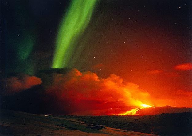
Hekla during eruption with Northern Lights.
Disregarding a few small volcanoes immediately east of Hengill is the SISZ, South Iceland Seismic Zone. At an angle of divergence of 0 degress we have the ideal conditions for the formation of a slip-slip graben, a zone of bedrock gravel, and this is precisely what we find. This zone ends about 10-15 km east of Hekla where the MAR takes off at a, call it, 30 degree angle. Hekla defies categorisation. It is a rift volcano with its own system of magmatic reservoirs that has fissure eruptions as well as plinian initial eruptions. But it is not just a rift volcano, it also is a stratovolcano and a shield volcano. The key to understanding Hekla lies in understanding its geological context and there may be no more than four people on the planet who do.
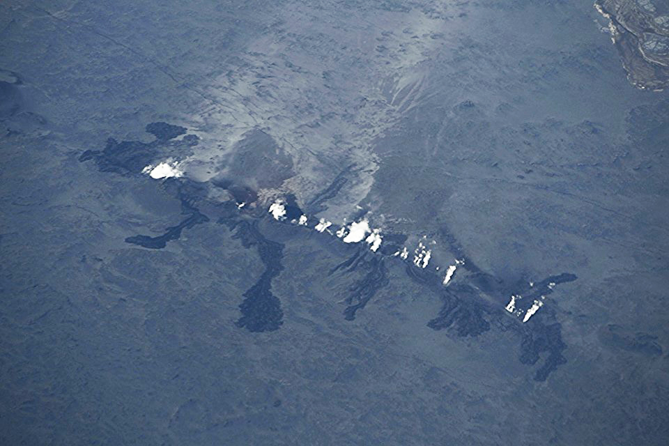
From Hekla there is a 30 km gap to Torfájökull and an additional 30 km to Katla. These two volcanoes, Torfájökull and Katla, mark the Western end of an area sometimes called The Dead Zone on account of its lack of seismic activity. In this area the rift runs at a 45 degree angle North-eastwards until it comes to Vatnajökull. Here is a combination of divergence and slip-slip which results in the gaps opening when the MAR adjusts are generally 40% greater than elsewhere. This area has hosted three major rifting event over the past 1,000 years or so – Eldgja in 940AD, Veidivötn 1477 – 80 and the Skaftár Fires of 1783-4. A quick look at satellite imagery such as Google Earth readily identifies this.
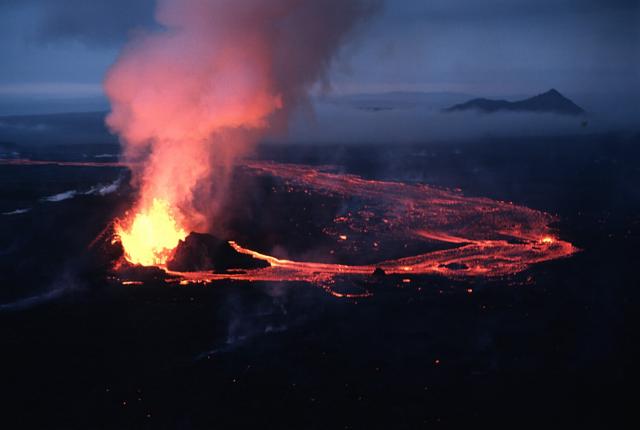
Krafla Fires 1984. Photograph by Michael Ryan, USGS.
Going back slightly, we see that the proposed route of the MAR through the WVZ is approximately 200 km long whereas the gap between Hekla and Torfájökull is only 30 km. If we instead of the first insert an area of rotation, a microplate, then we have a perfectly good and much shorter “gap” in our model. To those with a deeper knowledge, this is the why and how of the so-called Hreppar microplate and its counter-clockwise rotation.
Leaving the current area of activity for the moment, we go north to Krafla and from thence out into the Atlantic where it transfoms into the Tjörnes Fracture Zone. This area is know as the North Volcanic Zone and is characterised by having large basaltic shield volcanoes such as Krafla and Theistareykjárbunga. A look at satellite imagery reveals that the area is overflown by several largish and very smooth lava flows such as the Mývatn Fires 1724–9 and the Krafla Fires 1975-84 which the Icelandic Institute of Earth Sciences calls “a striking repetition of what happened during the “Mývatn fires” in the 1720’s.”. Here, the divergence is at 90 degrees and the result is that the typical eruption associated with a rifting event is a medium-to-largish flood basalt eruption.
We can now, finally, return to the Eastern Volcanic Zone where the MAR makes a 135-degree turn at Bardarbunga-Grimsfjáll to run almost but not quite exactly 90 degrees to the direction of continental divergence. A look at satellite imagery identifies that this area is subject to multiple small-to-medium sized rifting events and ditto basaltic eruptions, exactly what we have seen over the past week or so at Holuhraun!
If we go back to the SIL tremor charts over the past week or so, there have been – as one reader points out – several such small albeit subglacial eruptions that coincide with each spike in the red tremor line. The reason we have seen nothing is of course, like at Katla in July 2011, that the energy released by each such eruption has not been anywhere near sufficient to melt through the approximately 400 to 800 metre thick Vatnajökull glacier.

Wikimedia Commons
Now, what is going to happen? Probably not much more or at least nothing much more dramatic than we have seen even if the current episode could go on for days, weeks or even months. This could of course prove to be “Famous Last Words” if the proposed model is very wrong (which eventually it will proven to be). But should the current intrusion hit and interact with a body of eruptible magma, then most bets are off.
We still have a great uncertainty at Bardarbunga central volcano itself where freshly intruded magma could be in the process of interacting with older but still eruptible magma, the end result of which could be a spectacular eruption of anything from Grimsfjáll 2011 proportions and up to and possibly larger than the 1980 St Helens eruptions where the former is far more probable. The second uncertainty is if the intrusion front will stop or work its way up to either Herdubreid or Askja in which case we could be in for visually spectacular but hardly devastating or catastrophic eruptions.
At the present time, the risk of any eruption that could have any effect other than the nuisance of precautionary alerts outside the local Vattnajökull area are very small indeed.
/Pyrite


Nice video (by a RÚV cameraman) showing lava from the recent Holuhraun eruption:
http://www.ruv.is/frett/magnadar-hraunmyndanir-i-holuhrauni
Good morning Sissel … have a look at SMJ … is it the storm, man made or maybe just a general reaction to the ongoing quakes do you think?
I think it is caused by the storm. IMO weatherforecast is bad for today. “Southeast strong gale is expected, 18 to 25 m/s with with very strong wind gusts near mountains, strongest by the south coast and at the highland. No travelling weather for campers or cars with trailers and people are encouraged to take care of loose things. Heavy rain is also expected in the southeast part.
Prepared by the meteorologist on duty 31.08.2014 04:26”
What in hell is going on in Þórsmörk?
It’s only one station. Normally I would suspect human activity, but it’s the middle of the night… instrument fault maybe?
Weather radar shows the front beginning to dump on the South West of the island, Google Maps does not recognise “Smjorgil” any idea where it is?
not only is smj rising, so are at least 10 other sil sites that have been pretty level til now. I know some of them are south. I also follow the Hekla geophone at
http://www.jonfr.com/webicorders/tremoren.htm and it shows large activity. wind?
[IMG]http://i58.tinypic.com/fk1l5s.png[/IMG]
oops
Looks like the weather has arrived
The Wikimedia Commons image of Iceland above shows between Kerlingarfjöll and the rivers Thjórsá and Hvitá a region that looks like a former rifting fissure eruption zone akin to the EVZ. Most of it seems to go by the name of Hrunamannaafréttur, and surprisingly the images below are about the most of substance geologywise i could find on the net about it.
http://flickrhivemind.net/Tags/hrunamannaafr%C3%A9ttur
If so, it must be millions of years old, and would suggest that the Hreppar thing is pretty firmly stuck in place, as a turn by 180 degrees should have distorted the alignment substantially.
Serge
Who has never seen a Geology classroom.
What’s going on east of Askja? has the dyke somewhat bypassed it or what? http://www.vedur.is/photos/jarvatj/140831_0535.png
It does appear so, maybe it is going straight for the Stout Cake
IMO predicted that the bypass was a good probability.
They think that if it happened, it would run another 25 klicks to get to the tectonic faults further NW in the rift zone.
Better hope it doesn’t unzip now tho…..
fissure eruption right now!!
at 05:51
at 05:57
06:02 UTC:
at 06:03
check out Mila! its lava!
Thanks for the screen grab, completely webcam less at the moment 😦
Fissure eruption started.
Check cam2!
The beast has awakened again. https://www.youtube.com/watch?v=zKtGqoxV_qo
getting larger
Dammit! A Volcano watched never erupts.
First moment I have to go try to fix the engine so I can take the kids to school….
Camera is shaking – wind?
Yes, wind is picking up there. Here in Reykjavik has been heavy rain all night.
I wondered if it was a problem with the camera because cam 1 isn’t shaky and it’s nearby. Maybe cam 1, being a fixed camera, is more stable than cam 2.
Earlier I gave you an answer. Yes, it’s wind. The camera is very far away.
I wondered because camera 1 is close by and it isn’t shaking – I’m thinking that camera 1 may be more stable than camera 2 so less affected by the wind. 🙂
Traffic jam of scientists imo…
Interesting to have a bit of daylight activity so we get to have a look.
I was thinking the same thing – it’s great to have it in daylight! Just minutes before it started I was bemoaning the fact that all I could see was fog – thank goodness that has lifted! 🙂
Wind makes camera unsteady, but this apears timy eruption, same place, and it took some time get clear shot and upload to tynipic. Increadbly no rain there. In Raykjavik is Hurricane rain …. 🙂
You answered my question before I asked it – thank you for that, i s l a n d e r! I was wondering if it was in the same place. 🙂
Yup, and if this goes off and again, about a 1000 times, we get Irpsits Shield Volcano. 😎
It took Radio over 30 min catch and report, but it has. They know not much more than we see! Seems it started before 6-O´clock as Juniors schreenshots are labelled 05:51. This might get larger, if rifting continiues that is. Curious how little power behind this.
That would make Irpsit very happy 😀
lol very funny G y does any know how high the lava fountains are look quite small but it could be the height off the cam positions.
it looks like there’s a river in front of it that is steaming??
Keep the screen shots coming folks!! 😉
How long does the erupting fissure have to get or how high the lava plumes before the description “Fires” is added to the location?
Now the dust has returned and completely hides the eruption. We were lucky to see it for a little while!
Wind is picking up… sand storm, it appears, blocking the view…
And to think I was about to put up some curtains but decided to check in with the ‘puter downstairs first… spidey senses working well this afternoon! 😀
Dust hides fissure eruption:
Bardarbunga is ashamed of her small eruption.
Dragged from the dungeons by Spica
looks like the smoke is rising higher and higher, in spite of the wind and dust
The fast moving clouds are likely forefront of approaching exotropical storm already over S of island. Dust will likely be replaced by rain shafts soon.
.
Well hows the “Its dust” brigade this morning 🙂
They got 40 min of viewing, before sandstorm set in. 🙂 😎
It’s a geo convention !
It’s both this morning – everybody wins! The Sheepy Darlek Bar at VolcanoCafé is open and drinks are on the house! Grab whatever you fancy – coffee is at the end of the line. 😀
(░) (░)
_|_ _|_ |░| |░| |░| |░| |░| |░| (░)> (░)> (░)> (░)> (░)> (░)> [░]> [░]> [░]> [░]> [░]> [░]>
——–>>>> *goes direct to cofffeee ….. *
😀
Futurama – Coffee time!: http://youtu.be/hOxojQlelDM
Harmonic tremor climbing fast again
yup, havn’t seen the dyn step up like that without a drop since the start.
may get effusive this time
Getting smoky

You’re almost there – just delete the [IMG] and [/IMG] at beginning and end of the line. 🙂
Thanks

You’re very welcome – great pic, Crater! 🙂
Did anybody find the “Smjorgil” station (smj) on the map?
It’s on the north side of Eyjafjallajökull close to the glacier snout.
Its just west by the Gígjökull glacier, where flood burst north out of Eyjafjallajökull 14.04.2010,
Snjörgil (“Butter Canyon”) but I think this is storm-artifact (windnoise).
yay just caught some of he fire before the smoke / fog / dust moved in….oh well on with the packing for the first flight in 5 years (I hope).
Unlike Bob, they can’t send the coastguard out to pick up the floaters for a sample, this one they have to get in the zone for a scoop.
Dark, heavy rain cloud moving in…
RUV says the fissure has grown to being 1.5 km long now
Ooooh! 😀
Old fissure there was 1,5 km long. I have RUV radio open but did not hear that.
Dust storm still obscures vision from Vaðalda, 20 km away (?)
1,5 to 1,8 km long fissure, 10 times more hraun running now.
Really dark! 06:44 UTC:
http://www.ruv.is/frett/new-fissure-eruption-in-holuhraun
Aviation alert back up to RED.
Standard procedure. Untill furher notice.
from visir
“Martin Hensch, seismologist at the IMO, confirms as well that another small fissure eruption has started in Holuhraun, about at the same position as the eruption on Friday morning although it still has to be confimed. The eruption seems to be smaller than the recent one, almost no tremor is seen on seismometers according to Hensch.”
We already know all this. Look at hour old photos abowe. Takk.
noted, I shall keep my eyes more open at what is posted here
The webcams seem to have gone so I thought I would post what I have got so far


Rescued from the dungeons by Spica
No more than 4 links per comment.
Thanks Spica for your help getting this post up. Much appreciated and advice noted.
Now THAT is not a car Irpsit! 😉 😉
*Ssssss… do not wake him.* 😉
Rather congratulate him on new shield volcano birth.
In fact sveral cars have arrived there. Interview with Geologist on the spot, but thay all were fast asleep.. so no one probably saw this opening, Junior spotted this at 05:51 (as clear view opened up)… My phone rang 05:53. My Cumpter has been running all night, so only took minutes connect to “Bárð2”
Looks as though the leading edge shower missed damping down the dust, it just brought the wind. Probably 3 or 4 hours before the rain falling on “Islander” arrives at the fissure, so if the eruption only lasts as long as Fridays. It will be over before the dust is stopped.
Colin
But I think it will go on longer, from the look of Bjarki’s screenshot above.
Please keep the screen shots coming 😉
Colin
Not sure if this clip has been posted before. Sorry if it has, I couldn’t see it. Thanks to RUV (Radio Station/News Iceland) I’m not sure about the accompanying sound effects but really nice shots of the first fissure.
http://www.ruv.is/frett/magnadar-hraunmyndanir-i-holuhrauni
Thank you Diana, really nice shots.
Oh Diana, how can you ‘did’ Jean Michel Jarre. At least it sounds like his music.
oops ‘did’ should be ‘dis’ disrespect for ones not up with English youth speak.
I would if I could find a working screen:(
There is a VERY anomalous signal on the Smjorgil SIL station approximately 5 km North of the crater of Eyjafjallajökull. Since it doesn’t show on the other SIL stations nearby, it is probably nothing more than a rockfall.
Yes, a large Troll was returning home drunk, and fell, off his chair. He´s still trying get up before the sun shines and carves him to stone. *here have some cofffeee…*
Wind / Current Storm hitting station. Already solved abowe.
I don’t buy rockfall. Look at the secret place that must not be named; it’s been going strong for hours.
before I put my foot in it, can you give me a clue what the “place that must not be named is” ?
No. 🙂
Thanks 😦 . I’ll go an find somewhere more helpful then
(It’s an ZEFKLOP-ZEFKLOP-ZEFKLOP which doesn’t have the bandwidth to support widespread public access)
The only reason Mike was given access was as part of a vulcano-sociological study to test whether or not subjects privy to classified information could resist the urge to reveal it and why. Mike failed and will now be taken off the project, his access revoked. / Gunbjørg Sverrisdóttir, Project Manager
Storm vibrating the instruments.
Totally agree !
There is a buffer in the stream at Youtube possible to rewind several hours. Go back 1,5 hours from now and look at the new eruption
Link?
Thanks!
news from RUV with more details about latest eruption and a very nice picture.
http://www.ruv.is/frett/eldgos-hafid-ad-nyju-i-holuhrauni
They say volcanologists are less than 2 kilometers from here…
I’d bet they’re a lot less than 2km from the fissure now! 😀
Beautiful (+scary).
there’s an eruption going on right now on baroarbunga 2
I can see am small amount of lava now but it seems less active than earlier.
couple minutes ago he waved at us.
Its dust 🙂
Hi Scotsfjohns, you really ought to learn that dust, steam and smoke look different from one another. You can clearly see the difference in this picture where the dust is in the foreground and the steam and smoke of the eruption in the background.
Here is a close up video of the new eruption this morning
Can not get any video feeds across the internet connection I am stuck with at work, please keep posting the screen shots
From earlier this morning

pictures on a new line and they show up, nice one!
atleast they are supposed to do that 😮
Any word as to which way the fissure is unzipping?
If it is getting longer?
Colin
They said 1.5km long, a little longer than the last eruption, but still a very small event.
Where are people located if they can see live video of the action? I would be interested in getting a live video to stream from Finland if I can get an extremely reliable feed
there is a youtube feed https://www.youtube.com/watch?v=zKtGqoxV_qo
Maybe you can contact Mila?
Do not know if this is of any use:
“This livestream is meant to redirect some of the heavy traffic on the webcam and crucial icelandic met office websites.”
(see link above)
Webcam = Mila webcam(s) bardarbunga 1/2
content from: IMO, http://baering.github.io/
http://mila.is/english/about-us/management/
Language problems here. I think you are asking for reliable feed, or are you asking for link to watch just yourselfs. Direct link here. http://www.livefromiceland.is/webcams/bardarbunga-2/
(thrugh Mila Main Pages)
That link is useless as soon as any demand rises. Maybe its fine in iceland but in UK its a fail.
At the moment, VC is running at an hourly average of about 2,500 views or 60,000 per day. Just imagine the demand on the Mila servers with everyone desperate to get a view and pressing refresh or reloading in an attempt to get in!
Are You people up all night!! Everything for sience. Anybody knows How the dyke is doing? Closer to Arskja?
Dyke seems be at same place, but rift appears be open up from other side (Herðubreið).
*not expert*
Its dust!!! 🙂
Would be good to get an estimate of how high the lava plumes are, from the folks on the spot
I read somewhere they’re up to 60 meters.