Just to keep things in perspective.
Previously, Carl has pointed out just how lacking the VEI scale is.
VEI is based off of the total quantity of material that came out of the hole. In this respect, not a bad scale… but VEI means “Volcanic Explosivity Index.” What about the less energetic eruptions? Say, Kilauea? How about a volcano that makes a big show at first then oozes magma for a year afterwards? Eruptive sequences generally include the entire time that stuff is coming out of the ground, and in order to compare one eruption with another, one of the best comparison is by how much came out. VEI will be with us for some time, but it helps if you have some context as to what it means.
Eyjafjallajökull was out paced by Grímsvötn in about a day. Grímsvötn is a true monster, and fortunately for us, all it did was one of it’s lesser burps.
Here is a plot of volcanic plume height over a period of hours, and how much material, in “Dense Rock Equivalent” (DRE) that equates to. The formula was derived from Mastin et al, who essentially did an update on Sparks’ equation. The purpose was to get an estimate of the eruptive rate of a volcano based on sporadic or sparse information… such as only having plume height data of a remote volcano off in the middle of nowhere.

Image by GeoLurking. Click for larger image.
As you can see, for a sustained plume height at the indicated level, the mass adds up over time. As time goes on, eventually different levels of VEI are reached.
You can also see how Grímsvötn blew the doors off of Eyjafjallajökull’s “puny” eruption.
In “A multidisciplinary effort to assign realistic source parameters to models of volcanic
ash-cloud transport and dispersion during eruptions” L.G. Mastin et al there is a formula that allows a computation of the mass ejection rate based on plume height.
http://www.geo.mtu.edu/~raman/papers/MastinetalJVGR09.pdf
It’s geared mainly towards volcanoes located in remote areas (such as Cleveland) and proves to be a handy tool if you put in a little work.
VAAC reports are probably the most handy reports available for any given eruption. VAAC is most concerned about keeping aircraft from plummeting out of the sky, so they try to stay on top of the hazard. This also means that their reports, though good, are more focused on the threat than the volcano. What the volcano is actually doing is little concern for them… what it did do is the most important. This means that once a plume is lofted into the air, the max elevation of the plume sort of remains fixed until it dissipates. The threat envelope will move around with the cloud… and generally the max elevation will remain mostly fixed.
If you are lucky, the VAAC report will state somewhere in the warning what the plume height is over the volcano. That is the data that a volcanophile will keep track of. That gives you the current state of the eruption.
Taking the time stamps for each report, along with the height of the plume over the volcano, and adding in the heights and time stamps from what ever geological agency reports, you can get a pretty decent record of the activity levels, and make a rough estimation (using Mastin et al) of the total amount ejected.
You do this by interpolating the rate from one data point to the next. You could connect the dots using a straight linear trend, or you could use some sort of poly curve or cubic spline (what ever your spreadsheet or data fitting program is capable of). From this curve, you need to get the interpolated increments down to one second intervals. Once you have interpolated timestamps and the estimated column heights at those moments in time, apply the Mastin formula to determine the DRE rate.
Then you just sum those rates in order to fabricate the total amount erupted to that point in time.
It may sound complicated, but it’s pretty straight forward.
From Mastin et al
H = 2 * V^0.241
Solving for V
V = (H/2)^(1/0.241)
V = Rate in m³/s
H = Height in km.
And.. a very important caveat… the formula has an error envelope of a factor of four. That’s pretty large, but it gets you in the ballpark for eruption estimates.
A sample run:
This is about a fictional volcano. Since it’s my construction, I choose to name it Mt. Gibbons. (I’m a Billy Gibbons fan) On 1/15/2012 at 12:00, Mt. Gibbons erupted to an initial altitude of 15 km. A compilation of VAAC reports and eyewitness reports from the Soso MS Volcano Observatory, show this for Mt Gibbons activity (plume height)

Calculating the number of seconds since the start and re-plotting, we get

Now we apply the Mastin et al derived equation, this gives us the rate of the eruption.

This is where I cheat. Using the built in integrated function of Dplot, I have it calculate the integral. You can do something similar with your spreadsheet program if you calcuate the linear trend between each point, then put together a running sum of those calculated points.
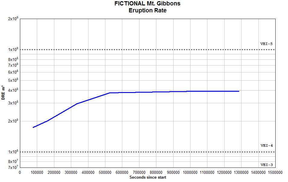
So.. as you can see, Mt Gibbons, starting to wane in activity at around the 24th of Febuary, will probably come in as a solid VEI-4. One thing that is very important, is to remember that the reference document, Mastin et al, clearly stated that there is an error factor of about four in the equation. In other words, this will get you into the ballpark, but it’s not full proof.
Enjoy!
GEOLURKING


Saw them live in Texas… Marvelous concert.
And a very good post.
For all the rest:
There is another post put on auto posting for tomorrow from Lurking.
In that one he explains why 5 Alarm Chilli with Beans are not good for a volcano. It will be posted at exactly 18.00 BT (Blog Time). Do not miss it!
Edit: I had written 3 instead of 5 in the comment. Kinky Friedmans will haunt me tonight for it…
I don´t know about the rest of you, but 3 Alarm Chilli with beans would not be very good for me either 🙂 Thanks Lurking for the post, I do get the drfit of what you are saying but the maths is a bit beyond me! (did I say a bit?)…. should have said, well beyond me!
I read it 3 times now, can´t say i understodd everything. Thanks Lurking, i ll try again tomorrow. BBGN
Avcan on their facebook page have also commented on the possible gas smells today;
,,But there’s more, like other days, today are noticeable especially well tremors, vibrations, dizziness, feeling of balancing and vibration or very short dry and strong shock.If this were a little today there is something new, we get reports of odors to gas in the center of Tigaday, still unconfirmed if they are of volcanic origin or not (can be a leak) but the truth if it is volcanic, smell rotten eggs, (H2S) or or rotten eggs and is spicy (SO2 with water pues.eso…),,
https://www.facebook.com/pages/Actualidad-Volc%C3%A1nica-de-Canarias-AVCAN/163883668446
Carl said a couple of days ago, we might/could expect something like it, kudos
Latest graph of the release of energy still climbing.
http://www.avcan.org/sismica/graficas/G1443.jpg?t=1344885715
I hope someone/organisation are now monitoring the gas levels another person has just posted this:
..A mi me preocupan mas los olores…. Alguien me puede decir como van las mediciones de los gases ?,,
,,To my I am concerned most odors…. Can someone tell me how measurements of gases are?,,
https://www.facebook.com/pages/Actualidad-Volc%C3%A1nica-de-Canarias-AVCAN/163883668446
Very good stuff, thanks GeoLurking.
An important question though. Is the eruption height measured from the point of eruption, or is it above sea level? In the case of quite a few big volcanoes that can easily be 3 or 4 km difference altitude. Does that mean that if, say, you get a plume to 20,000 ft from a 12,000-ft volcano, is the plume height 20,000 ft or is it 8,000 ft?
And to follow up here’s some OT-ish info about aircraft ‘altitudes’:
Apart from a few aircraft that use radar at very low level, aircraft altitudes are measured by an altimeter, which is essentially nothing more than a barometer that reads air pressure. It shows the decrease in air pressure as you climb, or the increase as you descend. The needle of the altimeter is calibrated to correspond to give an ‘altitude’ reading, which is typically done in three ways.
Most VAA/VAGs quote a Flight Level (FL) figure. It is a notional ‘altitude’ based on a standard atmospheric pressure setting of 1013.25 hPa (previously millibars, or 29.92 in/Hg in US money). Every aircraft flying on Flight Levels has the altimeter calibrated to the same pressure value, so the altitude differences between aircraft flying accurately to their assigned Flight Level will remain constant, no matter what the local differences in pressure/temperature. Combined with the quadrant/hemisphere rule this is a fundamental means of stopping aircraft from hitting each other.
However, while FLs do not reflect the actual altitude (unless the sea level pressure at that point just happens to be 1013.25 hPa and the temperature is 15°C and there are ‘standard’ temp/pressure gradients), they do give a relatively good approximation in hundreds of feet. FL200 for instance is roughly 20,000 ft.
The other ways of calibrating the altimeter are typically used at lower heights, which are elevation above a real-world point such as a runway (termed QFE), or elevation above mean sea level in the locality or region (QNH).
Inevitably, there are confusions. Some (former) Communist countries continue to use metric flight levels rather than feet. Russia only changed to feet less than a year ago. There are also different standard pressure settings for higher altitudes. Different countries also have different transition altitude rules. This is the level above which one changes from using a regional QNH setting to the standard Flight Level value.
Inevitably, there are confusions. Some (former) Communist countries continue to use metric flight levels rather than feet.
Huh, I thought everyone was using meters/km, at least in Europe? If you fly on almost any European air company (Lufthansa, SAS, KLM, Air France, Aer Lingus, to name a few I flew with recently), the pilot will tell you in local language whatever the altitude is in km and then will only say in English what the height is in feet (annoying, if you don’t understand the local language and are used to metrics).
Everywhere uses feet as standard apart from China and a few of the ‘Stans, Mongolia etc.
The pressure setting is the same, so the separation is maintained, it’s just the FL value that changes. FL100 over China is 10000 m (but still measured on 1013.25 hPa).
Some European airlines will give out altitudes over the PA in metres or km because that is what the populace is accustomed to. However, if you look at that ‘Airshow’ moving map thingy the chances are the height will be given as a round thousand of feet and a weird number of metres, because the aircraft is flying to a feet-based Flight Level.
The skip of the Air France A380 I was on last night talked in feet, and I have also recently heard SAS crew quoting feet over the PA. They are an interesting bunch (of course) because most of the Swedish crew are ex-Swedish air force, which was the last in Western Europe to convert to feet (and required the re-calibration of all their aircraft in the process). They don’t like it much, and it’s all NATO’s fault!
Let me clarify a few things…
UKViggen is talking about flight only when he states “Everywhere uses feet as standard”. The rest of civilization is happily leaving the dirty smelly feet system. Except in yachts, but hey, yachts are for buffoons that want to sound “classy”.
On the other hand, I fly a lot, and then I mean a hork of alot. I have never heard an airline not give both or meter only. I have never heard the pilot give feet only to the passengers. But inside the cockpit it is smelly feet for all their fot are worth.
Edit: And the answer is a 52 fot yawl. Nobody really knows what a yawl is, but it sounds even better when used together with the smelly feet. There is also a reverse curve between actually being able to sail and the amount of feet one is packing.
Carl said: I have never heard the pilot give feet only to the passengers.
Really? I have never heard any mention of metres (or even meters!) when flying in the US, or in most of the ‘old English world’. I’ll listen out specially tonight when I’m on SAA.
I don’t know why aviation chose imperial over metric – I guess it’s the power of the US influence. Aviation (mostly) uses knots and nautical miles as well, which you mention below. There’s something strangely gratifying to know that even in this world of GPS, terrain profile matching and lasers fighter pilots still plan everything at 480 or 540 or 600 etc knots (multiples of 60 – makes the timing/distance calcs so much easier!)
Actually it is due to the flyers using the knots system. They just nicked it all from the maritime environment. And when doing it that way it makes sense since there are sixty minutes to a degree = distance minute = nautical mile = 1 knot = 6068 nautical feet. Or roughly 101 feet per distance second.
So, it is not at all the US that are at fault for this madness, it is of course the Lord Admirals fault on behalf of The English Royal familly
It is the 101 thingy that really makes me giggle and reach for the bungadse. 101 fathoms to a distance minute and 101 feet to a distance second. This is the bottom line of the logic of smelly feet… 101 as a divider.
A bungadse is the tool that one uses to make the bungs that are bunged into the bunghole with the bungmallet. And as everyone knows a mallet always weighs more than 14 ounces, otherwise it is a pegger.
It’s also a lot to do with the outcome of World War II. Prior to 1945 all of Europe used metric for aviation.
What?
Nah… Can’t be, they used feet over Marne and Verdun, they might have changed somewehre down the road to becoming RAF though.
Oops. I meant all of Europe apart from the Brits. In the aftermath of WW2 there was a big rationalisation of international aviation, or at least the parts that were under US/UK influence (which included the French, although they were rather begrudging about it). The Russians wanted nothing to do with it until last November!
That’s for operations. Designing aircraft is another matter. The UK began using SI metric for design I think with the trinational Tornado. I believe (although I would have to check) that the Anglo-French Concorde was designed in Imperial units (the design owed more to the UK parent than the French one so that should not be a surprise).
Blimey, inverse snobbery or what?
I knew what a yawl is – it’s a 2 masted vessel like a ketch, but with the after mast mounted aft of the rudder post.
I used to sail quite a lot in the past, but apart from a bit of dinghy sailing always in OPYs. That is Other People’s Yachts.
Also a nautical mile is 6080 feet, apart from being a very sensible unit of distance because it relates to the size of the earth. It is one minute of arc along a line of longitude.
Not latitude because that is variable.
David B
Wouldn’t GPS be better than an air pressure altimeter in this day and age?
If I’m not wrong, I think the answer is like this. If someone states a column 20.000 feet high, that means it is 20.000 feet from sea level, even if the volcano is 12.000 feet tall. But for purposes of calculating VEI for the graph, one should discount that, and input a 8000 feet tall ash column. That’s important for volcanoes like in the Andes or Indonesia (tall ones); for Icelandic volcanoes, their size is rather small and columns are pretty tall, so it doesn’t matter
The column height is measured from the eruption vent, see eg.: http://www.cs.mcgill.ca/~rwest/wikispeedia/wpcd/wp/e/Eruption_column.htm or http://www.geo.mtu.edu/~raman/Ashfall/Syllabus/Entries/2009/6/21_Columns_files/WilsonErupCloudHeightJGR.pdf .
Well I also still work in feet and inches and pounds and ounces I cannot get my head round all this metric stuff . Give me a quarter of Waterhouses Butter Mints and a pound of Lincolnshire Sausages any day !!!
I am so glad that Carl did not set an entrance exam for VolcanoCafe I think I would have ended up on the slag heap .
OOOOPS sorry dont mean I am a slag I meant as in the slag heap re the mines when all the rubbish they mined was put to one side .
Today they have started to go through those slag heaps with a vengeance. Half of all Rare Earth Minerals are dug out of the slag heaps. I would be proud of being a slag heap.
See, but the rest of Europe has the opposite problem, we all work in metrics and have no idea about feet, inches and so on. 😀 The other day I was discussing people’s heights with my British friends and in the end we had to admin that we have absolutely no idea how tall the other one was. For example, I know exactly how tall is 180cm, but 5 feet 4 inches has no meaning for me. And one of the completely surprising and ununderstandable things for me when I was grocery shopping in London once was to have milk sold in pints instead of litres, I just could not get my head around that. 😀
Pints? Not quarts then? Imperial of course! 😛
Yep, pints! 568ml. 🙂
I have no problem with beer in pints, but I have never seen milk in pint bottles except in UK (not even in Ireland, they stick to litres and kms there – in fact, that is the only way to find out that you have crossed the border between Ireland and Northern Ireland on the highway, because the traffic signs for speed limit suddenly change from km/h to miles/h).
Dunno where you are shopping in the UK but we buy milk in London in 500ml or litre plastic bottles. Haven’t seen pints for a long time – but I am not a beer drinker. We do still use imperial measures for many things: e.g. the speed limits are still in mph.
This was a few years ago, but Tesco still has milk in pints:
http://www.tesco.com/groceries/Product/Details/?id=251314158
🙂
And to complicate things…
In pubs we either order “The Big Strong” (stor stark) that is 40 centiliters, or the larger pint. Only problem here, we get the american DRY pint that is slightly smaller at cirka 0,55 liters. The american Dry Pint is of course larger then the miniscule wet pint at 0,473 liters. Why we mindbogglingly use the Dry Pint from US I will never know when we have the domestic Skäppa that is a quarter barrel or 36.6 liters (Swedish parties was better before).
Some of the other supermarkets also have both imperial and metric measures for milk. Amazing what you learn here 😀
Concepts are fascinating. We grow up with concepts that have to be changed rather than simply re- learned. For me as a scientist I was used to using metric in the laboratory but stupidly found it hard to have a concept of 150 gms of butter in relation to making a cake. .
As the regulars in here know I am maths phobic. I am really scared of using numbers and even algebra . I think because for me it is associated with school room Maths.
Now I still make an imaginary picture whenever I need to get to grips with working out numerical problems.
1 bag sugar = 1 kilo or 2,2 lbs
4 apples = 1 lb or 1/2 kilo
1 metre = about 3 ft I visualise height in bamboo garden cane sizes.
I am very good at assessing weights but l am not so good at metric fluid volumes (I know how much 0. 75 litre is.=1i wine bottle full) .and still find distances and height hard to actually get an instant image. A 1,000 Ft Volcano I can imagine perfectly but 1,000 m height I have to stop and mentally work out how many feet before I can build my image.
Having explained all this I have to congratulate Lurking because I actually understand this post. and yes! The maths behind it is simple. I wonder if this is due to me being 100% interested and therefore subconsciously creating volcanic images or if Lurking is a natural teacher. I suspect it is both combined.
The four apples should be average sized Red delicious……NOT large Bramley cooking apples… two of those makes 1 lb…. 😀
…and so to bed before I get brain melt!!
When I was at Primary School in the late 1950’s we were taught in metric because we were told that by the time we left school everything in Britain would be metric. So I never bothered to learn the imperial stuff (rods, poles, perches and so on). A pint has always been half a litre in my head and I measure everything in metres and cms – but I know my height in feet and inches because (as you say Ursula) no one would know what I was talking about otherwise. All veggies and foodstuffs are sold in metric measures now (with imperial in brackets) so there’s no excuse for people over half my age to still work in imperial. And don’t get me started on cars being judged on their “miles per gallon” when petrol has not been sold by the gallon for over 20 years!
I grew up with metric, learned imperial in school as part of the English curriculum, imperial when we came to Australia and then metric after its change, I am still alive and can easily change from one to the other, as some older stuff is still done in inches/yards
What is imperial? And why is it called after an emperor?
The first time I took students to Europe we were on a bus tour and stopped at a service station. One of the students remarked on how cheap the gas (petrol?) was, thinking it was only 1€50 a gallon. That was when they got their first metric lesson: 1€50 a liter, a liter being approximately a quart, etc. So after multiplying by four, the 6€ gas didn’t seem so cheap after all. At the time 6€ was $8, and in the US the cost was about $3 a gallon. We had another metric “lesson” when a student ventured out all bundled up in on a “very cold” 15º day, without realizing that it was not Farenheit, but a rather mild 15º Celcius. Now I teach metric in class, as I think it’s good for them to consider a different way of doing things. 😉
A Smoot is approximately 1.7 meters.
http://en.wikipedia.org/wiki/Smoot
I was also a UK child of the ’50s and similarly raised with metric at school but imperial at home (my father lived into the 21st C still converting decimal p into shillings and pence). I was always amused that motion picture film was, until not so many years ago, measured in metric width but imperial length e.g. 400 feet of 35mm stock.
Metric fuel consumption (litres/100km) might legitimately be expressed in hectares. Linear cubed divided by linear giving a result in linear squared i.e. area. Imperial miles per gallon is the reciprocal thereof so that if asked, in the UK, what one’s car “did”, one might simply reply e.g. “x per square yard”. Who knew that dimensional analysis could be so much fun?
Regarding measurments.
I prefer fathoms, knots, nautical miles and soforth. The Telemetre and Tachymetre complications on my watch is of course set to this the most logical of measurments. Little known fact, as soon as you leave the ocean and go into the inland waterways in the US they all of a sudden change into kilometres, not miles. Why? Well, dude, try to make a hasty recalculation between a mile and the nautical mile? It is fairly impossible with fractionate division in the head. Instead as everyone know the nautical mile is 1852 meters. Easy to change between. And from the metric you can go for the smelly feet system if you wish.
A knot is the speed of a boat, if you go by one knot you will travell 1 nautical mile in one hour (1852 meters), or the highly logical amount of 101 fathoms to the nautical mile since a fathom is 1,8288 meters.
This is why there is only two types of sailors, those who are very sober at sea, or those that have permanently knocked the bung out of the bunghole.
And no you little naughty minded people. A bung is the wooden peg that sits in the hole of a wooden cask. You of course use a bungmallet to bung the bung into the bunghole.
I was saying, nope better not
Nope better not what?
And in the US Navy we used a radar mile = 2000 yards and reported distances to other ships in yards.
500 x the Pulse width (in µs) gives you the minimum range resolution of a radar in feet…
Its’ a rule of thumb thing. Retired EW here.
@GeoLurking, thank you for explaining the eruption rate again. 🙂
This is a map showing Tigaday where they are still commenting about the smells and it looks to be so close to Tanganasoga,
http://www.kyero.com/map/49776-tigaday-map
Interesting this latest map of the earthquakes shows a square formation around Tigaday,
http://www.avcan.org/mapas/AVCAN4019.jpg?d=1344805560
In this updated 3D graph you can see that the most recent earthquakes (bigger blue squares) worked their way up towards where everything started in 2011.
as was mentioned before, nature doesn’t like empty spaces, maybe some have been filled under El Hierro and it is priming Tanganasoga, time will tell
I will add more on the interpolation of the points between the reported heights later.
For now, after royally pissing off the “Level 2 – Network Support” girl since she couldn’t find a work request to move the T-1 circuit demarcation point and all I really wanted was the circuit designator so I could find the Pair Gain somewhere on the wall board… and I mistakenly assumed that I would just call the help desk to get back in touch with her once I found it… (that’s what set her off, she abruptly advised me that she didn’t work for the help desk)
Twit.
Anyway. The eruption column height as reported by the VAAC is in reference to sea level.
You would back out the height of the vent to get the actual height that you are trying to calculate off of, That’s the way the formula works. It’s also important that you eliminate any error factors (such as this) that you can, since the result can still be a factor of four off.
Back to the @$#$.
HP Compaq has an issue with one of their models of server. I have yet to move one of these servers that has not had a stirrup clip that has already detached from the motherboard… and with the Northbridge heatsink laying in the bottom of the chassis. I’ve run across so many of them that it has to be a defect when they flow soldered the board. Usually the server is still cranking along just like it should… but I’ve been told by the guys that own these things that they won’t boot without it. (haven’t seem em do that yet). Pull the board, find the clip – reattach it using 40 year old technology. Push it a bit further through and bend the tips over just a bit. Its not an electical connection, and all it has to do is hold the heat sink on. Haven’t had one fail yet after my proceedure. This also illustrated the prime difference in a Technician and an Engineer. A good tech will do what is needed to make the damn thing work without braking anything else. an Engineer will get lost in the minutia of how and why it failed and work to all hours to fix the manufacturing process. Though I am called a “field engineer” by trade, I stick to the old school mentality. “Does it work?” “No?” “Gimme a few minutes.”
And for you real Engineers out there (ones who actually deserve the designation) it’s a cold solder joint problem. Going back and redoing the design of a board that is out of production isn’t going to really help anyone.
😀
Twit? The Politically Correct term is Challenged Representative with Arrogant Personality, also known as a CRAP.
I am instead sitting half the night filling in a veeeeery long application that I can’t save, almost done I notice that I need an answer that I can’t get before the morning/mid day. I am now living in fear of A) My computer Blue-screening for some unheard of reason, B) Their server being a HP Compaq server that haven’t been Lurkinged, or that I will be timed out on my log in and I will have to restart a 40 page application. Nutters.
Oh! I know the feeling. All I want is a replacement blue polythene bag in which to place my paper and cardboard waste for collection by our local council.
I have phoned twice requesting one… each time they tell me “One is in the post for you”
This morning I find a long form to fill in (and also a long article saying why it is necessary to recycle….as if I didn’t know ). I have a choice, 2 sizes of wheelie bins , a blow awayless bag weighted and with ties or… a simple blue polythene bag.
I need a plain, blue polythene bag. I can carry that, my arthritis lets me,I don’t need to ask for help moving it, it takes up little space. I have no room for more bins. That is why I have requested a plain, blue polythene bag. I told them twice on the phone already. …….Sigh
It is not the wrinkles and creaky joints that make aging painful. It is the condescension and insistence by younger members of society that after 67 years your brain loses all benefit and memory of life experiences……..Sigh……..Gloom cloud descending so time for another coffee
And I who thought it was the total conviction that the brand new generation is fairly stupid… And, since the days of when Aristotle scribbled down his odé to the lost generation of loitering buffons it seems like humanity has just gone downhill. On the other hand, I was not that impressed with my own generation either… 🙂
condescension makes me cringe, when they talk about the dear old so and so is …..
Dear old is still better then “Gubbjävel”. That word is very much ruder version of Ol’ Fart.
Thank you VC for giving me an addition to words I can mutter in my annoyance without people actually understanding what I am saying. I can keep my apparently lady-like behaviour intact yet wickedly venting my spleen. Have you a good one for the younger Numpties that wander in front of my car oblivious to danger because they have their mobile phones apparently surgically attached to their ears or thumbs?
Wait ’til you are described as an Ancient Briton by a well-meaning friend from across the pond.
(“The Ancient Britons” is a term used to describe the indiginous population of England (& Wales?) prior to the Roman conquest of 43AD).
A 7.3 rocked Sakhalin in the Sea of Okhotsk a little while ago, it shows as a series of twin earthquake in iceland. Oddly it shows as heavy surface quakes with ghosts at 90km depth. All of these quakes are rubbish… It is Okhotsk, but the pattern is odd to say the least.
Hekla strainmeters show the quake very clearly.
http://hraun.vedur.is/ja/strain/1sec/index.html
Unusual earthquake to say the least. 7.3M at 579km Depth. This is a very rare earthquake, normaly they can not happen with this strength at that depth due to temperature making everything rather ductile. I do not think anybody will understand what happened really.
I would have been impressed if that idiot with his earthquake predictions had sauntered in 15 minutes before the quake and told us, especially since this was a pretty much unheard of qake… I bet he will be here later today stating that he knew about it.
Now, back to bed…
7.7 2012/08/14 02:59:42 49.784 145.126 625.9 SEA OF OKHOTSK
Upgraded, both in magnitude and depth.
They are not so rare. These deep focus quakes are about the only ones we have in Brazil, from the deep edge of the subducting Nazca plate under South America.
At this point, ductile mantle turns back to be brittle state due to some further crystallization from olivine to serpentine.
They are a good tell tale of the edge and subduction angle of the slab.
In Potosi, Bolivia, one deep focus reached above M 8,0 and in the state of Acre, Brazil, one of those reached 7,0.
A couple of years ago we saw a swarm of large deep focus at the Moro Gulf in the Philippines.
They are cool, and are felt much further than “normal” quakes.
Cool, there I got for not living in a large quake part of the world 🙂
Okay… the first thing is… this isn’t really that difficult
When you are traveling down the road, you are moving through a distance at a certain speed. If you know that speed, you can calculate how far you have gone if you know how long you have been traveling at that speed.
For example, say you’re doing 70 kph.
In one hour, you have traveled 70 km. In two hours, 140 km and so forth. If you travel for one hour at 70 kph and then slow to a speed of 30 kph after one hour, you travel a total distance of 100 km in that same two hour trip.
Easy enough. Now let’s change things just a bit. If you are traveling at 19.4444 m/s, and you travel for 7200 seconds (2 hours) , you will have gone 140000 meters. (140 km) If you travel for 3600 seconds at 19.4444 m/s and then slow to a speed of 8.3333 m/s after those 3600 seconds , you travel a total distance of 100000 meters (100 km) in that same 7200 second period.
All we have done is change the units… the calculations come out the same.
Using the second example, you can find the total distance traveled over any period as long as you know the speed.
32 seconds of travel in the first hour? 32 x 19.4444 = 622.2208 meters. Essentially, it is a sum of the distances traveled over each second.
Now, say that instead of speed, it’s 19.4444 m³/s of material being ejected out of a hole. In 32 seconds, it sums up to 622.2208 m³
All you have to do, is to get the time units into something that you can work with. I find it best to set the start of the eruption as close to the zero point, and the count sequence to either seconds, minutes or hours.
If the eruption is 10 km with a calculated rate of 794.8 m³/s, multiply it by 60 to determine the rate on a per minute basis. (if you are working in minutes) or 3600 if you are doing it by the hour. That yields 47,688 m³/minute or 2,861,280 m³/hour.
Suppose that our volcano went to 10 km at at 1/15/2012 at 12:00. Two hours later, the plume was down to 6km.
At time zero, the rate was 47,688 m³/minute. At time 120 (2 hours) the rate was 5727 m³/minute.
Using the slope formula: m = (by-ay)/(bx-ax) we can come up with this.
m= (5727 – 47,688)/(120-0)
m= -349.675
Substituting into the line formula: y=m*x+c
Y = -349.675 * minutes + 47,688
This yields the eruption rate at any specific time from 0 to 120 minutes. Dropping that into a spreadsheet and calculating each minute’s rate, then summing those cells, we have an idea of how much total material was erupted during that time frame.
These are the manual steps that will yield what we are after. It’s a brute force way of doing it without actually doing calculus. For each new report, you would calculate the slope for the next segment and tally up that material and add it to the what you previously got.
Not that I expect anyone to do it, but these are the essential steps. If you are handy at slinging spreadsheets of math programs, implementing this will give you the DRE of the eruption, and allow you to take a guess at how big it is. If you’re program is capable of fitting a spline to the points, you will get a smoother and likely more realistic result if you then integrate that curve.
Enjoy.
Good morning/ evening everyone.
This reminds me of correlating all my measurements after 2 week’s field work on a study I did for my finals. (The days before everyone had access to a computer and if you had one you wrote programs to fit your research!)
I remember sleepless nights as I painstakingly calculated and then transferred the points to graph paper and tracing paper overlays.
I still have the tomes I produced. Pages and pages of calculations.
They look impressive and the hand drawn graphs are very pretty, almost works of art. But now the whole lot could be done in a day, less paper, more sleep.
I can see why scientific research has progressed in leaps and bounds in the last 40 years!!!
Lurking thanks again for making the maths needed for volcano watching less daunting.
I put this one in my draft folder, to have a go at it when my head is a bid clearer, I always loved math, so will see what is left of it my grey matter
Lurk, do you happen to have read Dr. Clive Oppenheimer’s “Eruptions that Shook the World”?
In his book (sections1.3.2 and 4.1.2) he explains why he prefers to use an “eruption magnitude scale” to express the energy release (Like Richter’s for EQs) in terms of mass, not volume, because volume varies much according to the densities of ejected material.
His formula is something like: Me = log10(m) – 7. (Cannot type the correct subscript characters).
So, instead of a VEI 5 or a VEI 6, he talks about a Me5.2 or a Me 6.1.
“For instance, five cubic km of magma with a density of 2600 kg per cubic meter corresponds to a Me of 6.1. An eruption twice the size (ten cubic kilometers) of the same magma equivalent, to a Me of 6.4.”
And he adds that VEI was a prior method to measure that he no longer uses.
It kind of got me a bit confused while reading the book, because , like Diana, I am not exactly a Maths person.
Could you tell us a little more about that, if you happen to be familiar to his method?
A propos, I’ve heard that Mt. Gibbons is overdue for another big blast, is that true?
I don’t know about that scale, but it makes sense to use such a measure of mass rather than volume. But still it does not express the intensity of eruption. I think any equation should include both the height of ash column and the measure of mass erupted per unit of time, and also per area of crater (because large crater need much stronger intensity to release the same eruption column height.
About “overdue” volcanoes: there is no such concept in nature.
Volcanoes erupt when magma from the depths came and the pressure is enough. They can have big blasts in a relativety short amount of time, or go long times with sleep, and have very irregular patterns of eruption. The concept of “overdue” does not exist.
For example, Katla could well sleep for another 100 years. Is that even possible? Yes. For instance Hekla has been erupted every 10 years but it had once slept for several centuries. Some volcanoes even sleep for million of years before returning to activity (example of Snaefellsjokull)
“About “overdue” volcanoes: there is no such concept in nature.”
True, but Mt Gibbons is long overdue, this is a fact. And when it goes, you better keep an eye on the fret board.
Where is mount Gibbons. Does it go by another name? I couldn’t find a thing on it in the GVP database, and it didn’t show much in google search either.
As for overdue volcanoes, I know it’s a fallacy to say as a fact a volcano is “overdue”, but there is at least a minor bit of truth to “overdue” being a reality.
If we were to assume that volcanoes would be getting a relatively constant influx of magma / pressure into their system, and we know that they erupt once per every 100 years for example, it would be pretty safe to assume that a volcano is statistically “overdue” if it had been 150 years since the last eruption.
That being said, that’s only assuming the same energy is being pushed into the volcanic system as had been in the past, the same type of magma / gas content, and no other factors being involved as well. “Overdue” can in a very very minor way suggest a higher likelihood of an eruption, but it also is a gross oversimplification of much more complex processes which shouldn’t be used to predict or judge an eruption.
That’s because GeoLurking made Mount Gibbons up.
In the parent post, the full name of Mt Gibbons is “Fictional Mt Gibbons.” It was used as an example. Named after guitarist Billy Gibbons of ZZ-Top. Hence the reference to a fretboard.
Well, that makes sense. Forgot the fictitious name. That being said, Gibbon Hill is a lava dome in Yellowstone, so I wasn’t sure if that’s what was being referenced.
OT but two new sets of Pryamids in Egypt have been found by an American Scientist studying Google Earth.
http://www.dailymail.co.uk/sciencetech/article-2187788/Two-previously-unknown-sets-heavily-worn-pyramids-discovered-Egypt-Google-Earth.html
My thoughts are with our friends in the Canary islands. Has anyone any news of Debbie? My condolences to the grieving families and I pray for rain or a beneficial change of wind.
http://www.dailymail.co.uk/news/article-2187809/Canary-Islands-Wildfires-Foreign-Office-warn-tourists-firefighters-killed-7-000-homes-evacuated.html
Debbie wrote about it yesterday, she says fires are under control on Tenerife but unfortunately not on La Gomera: https://volcanocafe.wordpress.com/2012/08/13/answers-to-name-that-lava-xx-and-alans-evil-riddle-13/comment-page-1/#comment-57750
Please, let it rain!
That’s the same as the advisory from the Foreign Office:
http://www.fco.gov.uk/en/travel-and-living-abroad/travel-advice-by-country/europe/spain
I only know to well about the fires, sometimes you just have to let it burn and save infrastructure/houses etc. natures does what is does best to destroy to rebuild, it is awesome, beautiful nd scary all at the same time
apparently it is (or was) burning a “world heritage site” forest which was rather unfortunate
Also around the Mediterranean and perhaps on the Canary Islands as well, forest fires are often due to arson (land property speculation or such). 😡
BBGN
Shleep very well.
The first EQ today at only 10 km deep.
1161084 14/08/2012 08:00:53 27.7470 -18.0804 10 1.2 4 W FRONTERA.IHI
ign.es
TV journals in Rio are giving daily updates on the fires in La Gomera. They depict a horrendous scenario.
:((
Earthquake on La Gomera? http://www.ign.es/ign/resources/volcanologia/EGOM/imagenes_sismica/DIA_SP/EGOM_2012-08-14_sp.jpg
Fortunately not. It´s a teleseismic event from the 7.7 rocking Sakhalin, Russia.
Thanks chryphia, I lost the connection with IGN and could not look further.
ack.. am in the middle of the Massif Central visiting rellies and don’t have my handy folder of scientific folders at hand… but I have a vague recollection of Wilson or Walker doing a paper on eruption heights with a neat little calculation that also includes the radius of the vent which intuition tells me should be a pretty critical value when comparing the mass ejected to the height of the column (i.e. thin high velocity jets can reach high altitude but eject less volume than a wide low velocity jet of lower altitude..) see if I can find it before cocktails are served.. (these family obligations, honestly!)
ah, that’s right, there’s this paper, which you probably already aware of :
Click to access plinian.pdf
not the one I was thinking of, but good formulas for calcuting buoyant columns vs. collapsing ones..
Yes, and a very good one that it is.
The Idea behind the Mastin et al approach is for volcanoes that you can’t get to and look at in detail… and for us, that pretty much applies.
The Volcanologists can get up close and personal, we can’t. While we wait around for the real analysis, we can at least get into the ballpark about what size it was.
Thanks for the Link! I tend to misplace pdfs across multiple drives. I’m also trying to consolidate them.. sort of. What would be cool would be to set up HTDig on them so I could key word search the files… without using a potentially invasive Google product.
Side note…
“BEST” did a re-analysis of temperature and forcing… naturally coming up with mankind caused warming. (It was a Berkley program after all). In this re-analysis, and in an attempt to reconstruct their process… since for some strange reason, climate “scientists” invariably hide or obfuscate some aspect of their work, it seems that either their forcing is a factor of ten off, or GISS is a factor of ten off, or some combination of that.
Willis Eschenbach stumbled across this oddity while trying to reconstruct the BEST teams work.
http://wattsupwiththat.com/2012/08/13/best-volcanoes-and-climate-sensitivity/
Not related… but just freaking weird.
“National Weather Service buying hollow point bullets?”
It’s sourced from The Drudge Report and Infowars (now there is an excitable cuss if ever there was one), and one would normally count this as loons hopping around… but there is a screen cap of the actual bid request.
National Weather Service… needs ammunition. Makes ya go “eh?”
http://wattsupwiththat.com/2012/08/14/wtf-national-weather-service-buying-hollow-point-bullets/
… and to prove that google is really bad for family well-being… while searching just found this on pf’s… alright, I’ll save it up for the middle of the night, post-cocktails…
http://volcanology.geol.ucsb.edu/erupt.htm
PS does anyone have some good info on the Massif Central.. I’m here after all, I have to check it out, despite massive (err) family resistance..
A book re. Geology of Auvergne:
Peter Cattermole: Classic Geology in Europe 2. Auvergne. Harpenden (Terra ed.) 2001 🙂
It depends where you are in Massif Central … Auvergne, Lozère, Aveyron … ?
Anyway they’re volcanoes, great walk and landscape, good food (and drink) and people who try to speak english like me).
Hi
one of the good places to use as a base is Clermont Ferrand, the chaîne des puys is just near.
Also you can try to use La Bourboule or Le mont dore which are near the famous Lake Pavin which is a maar. La Bourboule and le Mont dore are thermal town so the food is good.You can also climb the puy the Sancy or move south to Cantal which is a supervolcano. Chaude aigues boast a hot spring @ 82°C and you have some basaltic organs in the nearby Saint Flour. Do try the truffade which is potatoes with some motlen cheese. The “saucisson sec” is famous. Well, enjoy !
Bruce
just tell near where you are and I’ll find something.
Lake Pavin is more easy to access from Besse / Superbesse ! But I think a part of the walk is closed (landslide).
I agree that “truffade” is not a good idea in August …
Salut François !
I do not agree, truffade after a long walk on the Aubrac plateau is just perfect !
Anyway there is also Aligot and sausage 😀 very light. With some Cantal cheese to finish….and a small bit of Fourme d’Ambert.
You’re right about Lac Pavin and Superbesse. Too bad about the landslide….the color of the lake is sort of blue to milky blue, very pleasant.
Lut Dfm,
Avec la truffade, le problème c’est que c’est chaud et lourd … En tant qu’Auvergnat (63), j’ai déjà testé un midi au mois d’Août dans un resto improbable. Bilan : sièste au lieu de rando ! Mais j’adore … Et ne pas oublier les fromages, pour moi 1 semaine sans Saint Nectaire et je suis en manque …
Pour le Pavin, çà date d’un an il y a tellement de randonnée à faire ici que je n’y vais pas tous les ans, Mais je suis sûr que par précaution, une partie du tour est déviée.
Pour Bruce, si il a des enfants, il y a la luge d’été à Besse / Superbesse + accrobranche …
Et au Mont-Dore il y a une cascade sympa.
Bref, que de randonnées, pour moi des marches de 15 à 20 km chaque WE, et toujours différentes …
Par exemple, il y a des grottes sur certains volcans de la Chaine des Puys (Sarcoui mais trop facile, voir Le Petit Suchet plus hard), ce qui motive ma fille de 10/11 ans !
A+
Dfm,
With the “trufflade”, the problem is that it is hot and heavy … As I’m Auvergnat (63), I have already tested a midi in August in a restaurant unlikely. Conclusion: siesta instead to hike! But I love … And do not forget the cheese, for me one week without Saint Nektarios and I’m missing …
For Pavin, I practise a year ago, but I do not go every year, but I’m sure a precaution, part of the walk is deflected.
Bruce, if he has children, there is the summer luge in Besse / Superbesse + tree climbing (“accrobranche”)…
There is a nice waterfall in Mont-Dore.
In short, whether hiking, for me the steps 15 to 20 km each weekend, and always different …
For example, there are caves on some volcanoes in the Chaine des Puys (“Sarcoui” but too easy, see “Le Petit Suchet” more hard and better for fun), what motivates my daughter 10/11 years!
A +
How could I forget the Saint Nectaire !
😆 I love you Frrench guys… no sooner do we talk about volcanoes than the conversation turns to cheese and food.. I knew it, I should have been born here. Ok, nous sommes pas loins de Chassignolles (southwest corner) mais el n’est pas loins de Clermont Ferrand.. et nous avons une voiture 😉 cripes, my French is pretty miserable. My cousin wants to install a septic tank but the ground is solid basalt!!
Bonjour Fanfoe! many thanks for the comment! I just researched Besse and Lac Pavin and found this:
http://www.saga-geol.asso.fr/Volcanisme_page_exposes_lac_Pavin.html
Will go there either today or tomorrow. Luge for Finn (9 ans) and Maar for me (50 ans) … happiness!
… and hope it doesn’t suddenly burp out its CO2 while I am there!! (sounds like a candidate for the next Nyos type catastrophe!!)
here is a link on Cantal volcano for those interested.
Click to access cantalbvolc.pdf
Hello Bruce,
Your french is perfect !
I hope you’ve seen volcanism near Le Puy (43) and eaten some mushroom (even if it’s more in September because of no rain this moment) !
BE CARE of STORM (orage) this afternoon …
For Pavin, no risk for CO2, but they observe a slow collapse.
For food, the best for me is Dordogne (24) and Lot (46) …
Enjoy !
Avcan have reported that the graph on the link below shows the average depth of earthquakes located by the IGN in the interior of the island of El Hierro island building from June 24 and until 12: 00 on August 14, 2012.Earthquakes grouped by 6 hours. 2,460 Earthquakes are represented.
http://www.avcan.org/
IGN have reported that EHIG has been damaged in the fire and they are waiting for permisiion for it to be repaired.
,,Instituto Geográfico Nacional Spain – CNIG unfortunately seismograph station EHIG of the IGN on La Palma, burned in the last fire and is out of service. We are waiting for permission to be able to repair it.,,
http://www.01.ign.es/IGN/resources/volcanologia/HIERRO.html
Oooh…. that means we can pull the seismicity of being consumed by fire!
Undersea eruption caught on satellite. … They then identified the likely source of the eruption as the Havre Seamount.
The eruption was strong enough to breach the ocean surface from a depth of 1100 metres.
By July 21, the eruption appeared to have waned, leaving behind the dense rafts of pumice. http://www.stuff.co.nz/science/7476032/Latest-NZ-eruption-caught-on-satellite
must have had a bid of umpf to get 1100 m up in the middle of the ocean
Volcanic activity world-wide 14 August: Tungurahua, Etna, Long Valley, Popocatépetl, Fuego, Santiaguito, Pacaya, Nevado del Ruiz, Sotará, Bagana, Batu Tara, Sakurajima
Tuesday Aug 14, 2012 17:03 PM | Age: 2 hrs http://www.volcanodiscovery.com/view_news/12780/Volcanic-activity-world-wide-14-August-Tungurahua-Etna-Long-Valley-Popocatépetl-Fuego-Santiaguito-P.html
New post is up.
Given GeoLurking’s diligence in plotting stuff, the advert I saw on this page somehow seems appropriate: