Icelandic Coast Guard, courtesy of Allmannavarnir Twitter page
One of the more persistent reader questions is “What will/can happen now?”. I am pretty convinced that this question is what occupies most people on the inside of IMO, Allmannavarnir and NordVulk as well. The words of several eminent vulcanologists, that this episode is unprecedented, indicate that this may indeed be so. But in order to be able to answer that question, one must have a working model for how the MAR propagates in the area concerned.
I am not laying any claims to having solved it, stone tablet fashion, far from it. I only present a theory that does explain some of it, full well knowing that it could be – and will eventually be – proven wrong.

Schematic view of the Mid Atlantic Ridge as it runs through Iceland (www.chromographicsinstitute.com)
The key to how the rifting occurs is in my opinion the angle at which the North American and Eurasian plates diverge. If we divide the MAR as it runs through Iceland into zones of commonality we can identify just such areas.
Beginning where the MAR comes ashore at Reykjanes, the angle of divergence is very small. Four our purposes, let’s call it a 15-degree angle. In the Holocene (last 10,000 years or so), there have been several largish flood basalt eruptions, but the volcanoes of the area and the associated volcanic eruptions are generally speaking relatively small with one exception, the giant shield volcano of Hengill that marks the end of this area of commonality.

The MAR then runs North-eastwards and is labelled the WVZ, the West Volcanic Zone. The angle of divergence from Hengill to the volcanoes of Langjökull is 45 degrees. Just beyond Langjökull, the MAR then makes a 45-degree turn to run perpendicular to the base divergence or 90 degrees where it runs through the volcanic Hofsjökull area before rejoining the main rift at about the location of Tugnafellsjökull just west of Bardarbunga. Let me state immediately that I am not to keen on the WVZ really being the MAR. It is too long a junction, about 200 km as compared to the shortest route which is a mere 30 km.
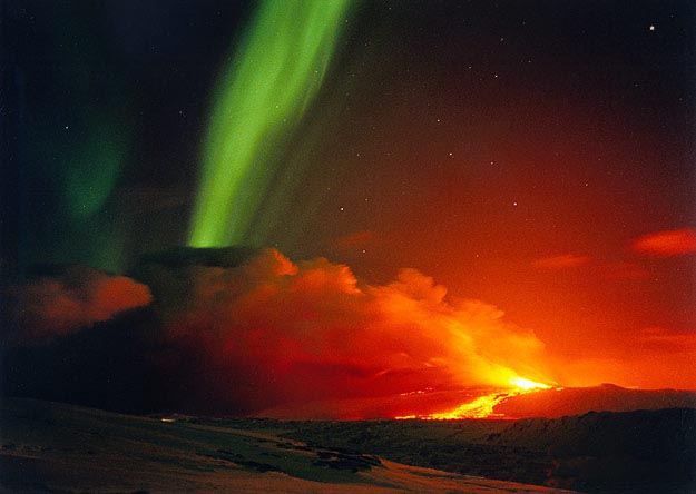
Hekla during eruption with Northern Lights.
Disregarding a few small volcanoes immediately east of Hengill is the SISZ, South Iceland Seismic Zone. At an angle of divergence of 0 degress we have the ideal conditions for the formation of a slip-slip graben, a zone of bedrock gravel, and this is precisely what we find. This zone ends about 10-15 km east of Hekla where the MAR takes off at a, call it, 30 degree angle. Hekla defies categorisation. It is a rift volcano with its own system of magmatic reservoirs that has fissure eruptions as well as plinian initial eruptions. But it is not just a rift volcano, it also is a stratovolcano and a shield volcano. The key to understanding Hekla lies in understanding its geological context and there may be no more than four people on the planet who do.
From Hekla there is a 30 km gap to Torfájökull and an additional 30 km to Katla. These two volcanoes, Torfájökull and Katla, mark the Western end of an area sometimes called The Dead Zone on account of its lack of seismic activity. In this area the rift runs at a 45 degree angle North-eastwards until it comes to Vatnajökull. Here is a combination of divergence and slip-slip which results in the gaps opening when the MAR adjusts are generally 40% greater than elsewhere. This area has hosted three major rifting event over the past 1,000 years or so – Eldgja in 940AD, Veidivötn 1477 – 80 and the Skaftár Fires of 1783-4. A quick look at satellite imagery such as Google Earth readily identifies this.
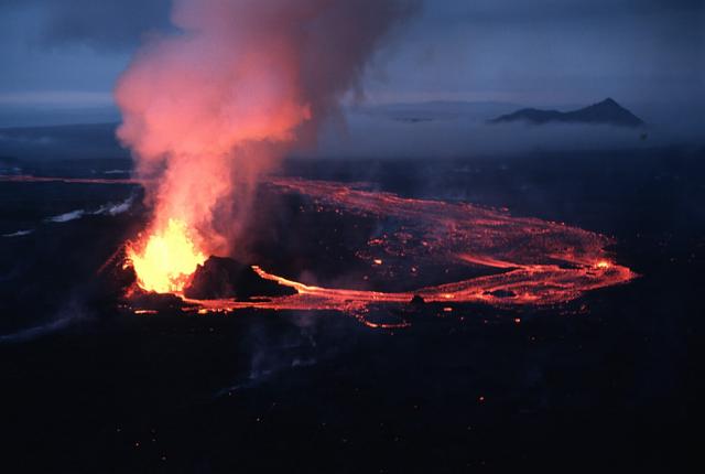
Krafla Fires 1984. Photograph by Michael Ryan, USGS.
Going back slightly, we see that the proposed route of the MAR through the WVZ is approximately 200 km long whereas the gap between Hekla and Torfájökull is only 30 km. If we instead of the first insert an area of rotation, a microplate, then we have a perfectly good and much shorter “gap” in our model. To those with a deeper knowledge, this is the why and how of the so-called Hreppar microplate and its counter-clockwise rotation.
Leaving the current area of activity for the moment, we go north to Krafla and from thence out into the Atlantic where it transfoms into the Tjörnes Fracture Zone. This area is know as the North Volcanic Zone and is characterised by having large basaltic shield volcanoes such as Krafla and Theistareykjárbunga. A look at satellite imagery reveals that the area is overflown by several largish and very smooth lava flows such as the Mývatn Fires 1724–9 and the Krafla Fires 1975-84 which the Icelandic Institute of Earth Sciences calls “a striking repetition of what happened during the “Mývatn fires” in the 1720’s.”. Here, the divergence is at 90 degrees and the result is that the typical eruption associated with a rifting event is a medium-to-largish flood basalt eruption.
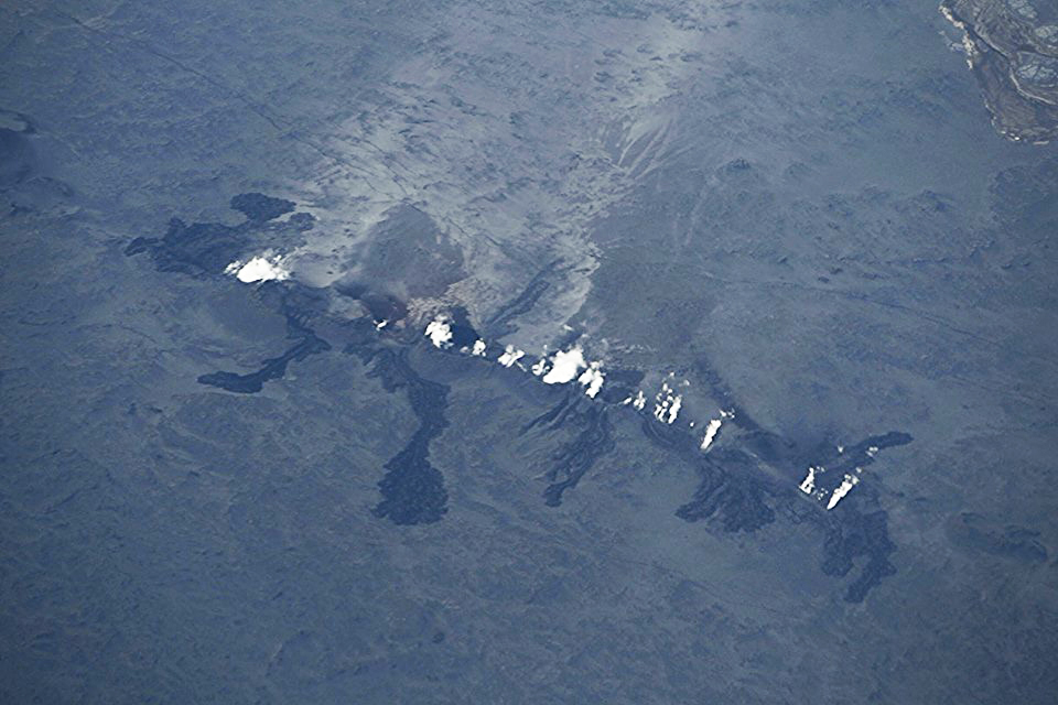
We can now, finally, return to the Eastern Volcanic Zone where the MAR makes a 135-degree turn at Bardarbunga-Grimsfjáll to run almost but not quite exactly 90 degrees to the direction of continental divergence. A look at satellite imagery identifies that this area is subject to multiple small-to-medium sized rifting events and ditto basaltic eruptions, exactly what we have seen over the past week or so at Holuhraun!
If we go back to the SIL tremor charts over the past week or so, there have been – as one reader points out – several such small albeit subglacial eruptions that coincide with each spike in the red tremor line. The reason we have seen nothing is of course, like at Katla in July 2011, that the energy released by each such eruption has not been anywhere near sufficient to melt through the approximately 400 to 800 metre thick Vatnajökull glacier.

Wikimedia Commons
Now, what is going to happen? Probably not much more or at least nothing much more dramatic than we have seen even if the current episode could go on for days, weeks or even months. This could of course prove to be “Famous Last Words” if the proposed model is very wrong (which eventually it will proven to be). But should the current intrusion hit and interact with a body of eruptible magma, then most bets are off.
We still have a great uncertainty at Bardarbunga central volcano itself where freshly intruded magma could be in the process of interacting with older but still eruptible magma, the end result of which could be a spectacular eruption of anything from Grimsfjáll 2011 proportions and up to and possibly larger than the 1980 St Helens eruptions where the former is far more probable. The second uncertainty is if the intrusion front will stop or work its way up to either Herdubreid or Askja in which case we could be in for visually spectacular but hardly devastating or catastrophic eruptions.
At the present time, the risk of any eruption that could have any effect other than the nuisance of precautionary alerts outside the local Vattnajökull area are very small indeed.
/Pyrite


Is it possible this is going to be the MAIN eruption Site??
I am starting to believe so. I think this might be the site for a future shield.
Yes Carl, I think we might see two very likely scenarios:
Besides all not-so-likely scenarios.
The likely 2 are these:
– A repeat of 1797 but with the scale of the Krafla fires. On and off small fissure eruptions for months or years over the sight between Dyngjujokull and Askja. Possibly even with minor eruptions near Herdubreid some years down the road
– A shield slowly forms in the region, but this would take a very long time. This is my second likely scenario, but of course I don’t know the odds of it. As this never happened since Icelandic settlement!
So, yes, two scenarios to watch out for: 1) a sort of Krafla fires scenario, 2) a Shield volcano being born over a long time
The not-so-likely scenarios are all the others, with Bardarbunga explosive behavior near the calera being the likeliest, others include Askja eruption, a major rifting eruption, significant ash eruption near Dyngjojokull, etc, etc…
It seems unlikely also that the dike would just stop and no further eruption would happen.
Well, I agree, either this will be Holuhaun 2 with Holu Fires. Or we get Irpsitadyngja.
One more, Irps-dynju-sjór (after it ripped open and went caldera) sttretching between Holuhraun and Herðubreið. Wait and see. A few million years at most. 😉 😉 🙂 😎 *kidding of course*
Its dust…..
Short answer, standardVC non expert caveat: Yes 😀
But to expand a little, the fact that it’s seems to be ongoing is suggestive of this being the main site.
Watching the plots by DFM and others, we have seen the earthquakes go beyond here and then reverse, the magma has found a way out. The eruption is happening in and around a line of previous cones, so we could be watching one of the events that will eventually produce a new shield volcano…
And if that connects down to the mantle we will have seen something never seen before (again) and that would be the birth of a new central volcano.
Looks like it picking up a notch
Yes, serious ding-dong.

What’s interesting to me as a newbie is that it looks like it’s starting to bank up alongside the fissure. I’m not having to squint so hard to see where it’s coming from as there is a nice distinct black mound at the foot of the smoke (and occasionally visible lava). I am really looking forwards to nightfall if this keeps up, as the lava should be much more visible.
Even my fed up husband has conceded this new event is “exciting”. He was particularly impressed with the Twitter pics posted upthread.
Hi volcanoholics. Safely landed in Iceland last night. So glad I decided to still go ahead with the trip, exciting times! Do you maybe have any good tips how to witness the eruption, for an amateur like me. Maybe a fly over? I wouldn’t want to be in the way of the professionals. Thank you again for all you do and all the info on here!!
I would talk to Islander (commenter here) about it.
This comment will most likely disappear in the flow, so chase him when he comments. He is The One Who Would Know 🙂
Thanks Carl 😀
Start making phonecalls… Call Myflug up at Mývatn, or Eagle Air in Reykjavik, Atlantsflug ín Reykjavík, or three Heli companies in Reykjavik, and one lone Robinsin flying up in the north. Volcano Heli. Steat ticket by Helo, flying across the country, might cost 1200 USD or more, if they are ALLOWED fly. I have my doupts on any fly-ban zones for visual flight. To me there seem be lack of certain legal background and likely and overestimate of possible danger. Remember more peole die in their sleep than in air-crashes. *not expert*
Uhm…
You are an expert on air-crashes… 😉
At the moment most danger comes from … weather…
*not unexpert*
It’s a bit of a worry when one’s pilot claims extensive expertise in air crashes….:?
Thanks islander!
Carl, no plans to come to Iceland?
Islander: I am also interested to know if you know something about the best viewing you think that they will allow for the common citizen.
KatW,: would like to help you with that, but it seems hard enough for someone living in Iceland and with a 4wd, for a simple tourist the hopes are from the ring road some 100km away. The eruption site is remote, full of glacial rivers to ford and only a sturdy 4wd can get there.
I am thinking how to get there tomorrow…
Yes, there are plans… 🙂
“I have a most evil and cunning plan…”
Great, not. That will be the end of the eruption !!! 😦
Seriously, come and we should do a VC meeting in Iceland. I would gladly take you to some nice volcanic sites, depending of course on time of the year 🙂
I always said, besides Grimsvotn, Bardarbunga and Dynjujokull is the most remote possible eruption to get to see in Iceland. Even before all of this, I though about that if a fissure would open near Kistufell it would be hard to get in there. That road F910 is branded the most difficult road in Iceland. Not for me. It kills 4wds easily. Just think this: Sinking sand in glacier rivers.
Also a further thought about the southern F910. Think of the seriously excessively big wheels. You’ll need them, trust me! (hiked there this summer) 🙂
I’m sure i heard somewhere, that there is a shortage of photographers in the area ;). If you need anything to further scientific knowledge, I might be able to offer my services.
Ha Ha, as I speak high quality photos are beeing smuggled out from the zone,
not serious shortage anymore, I think. *not evil, just kidding*
I had to try :P.
What a shame your knee will take weeks and weeks to heal…. 🙂
Irpsit, let me know how you get on with that 4wd. I wish you a safe expedition and amazing views!
Thorbjörg Agustsdottir on Twitter, 9 min. ago:
“30 m high lava fountains, 1,5k(m?) eruptive fissure, several lava flows, at least 800 m long and 100 wide.”
https://twitter.com/fencingtobba
Would be interesting to know, if there are still people working there in this storm or if the informations came by satellite.
26 m/sec. average wind velocity, gusts up to 33 m/sec. and still going up.
http://www.vegagerdin.is/ferdaupplysingar/faerd-og-vedur/sudurland/linurit/st199.html
(soutwest of Bárdarbunga)
and the station next to the eruptions (Kreppuhraun):
SSE 17m/sec. (average wind speed)
gusts up to 27 m/sec.
http://www.vegagerdin.is/ferdaupplysingar/faerd-og-vedur/austurland/linurit/st192.html
Cam 2 zoomed right in close now. Fantastic to see the fountaining!
Hope pasting pictures will work…
4 Screenshots of the last few minutes:
Sorry Trebis, but html embedding code doesn’t work on this site. I tried editing it for you but only got the thumbnails to work. I’ll have another go at it. /babydragonbruce
Don’t know if this was posted before. (Second try:)
Thorbjörg Agustsdottir on her Twitter account, 19 min. ago:
https://twitter.com/fencingtobba
“30 m high lava fountains, 1,5k long eruptive fissure, several lava flows, at least 800 m long and 100 m wide.”
Weather at eruption site (nearest weather station is Kreppuhraun):
SSE 17m/sec., 9°C; gusts up to 26 m/sec.
http://www.vegagerdin.is/ferdaupplysingar/faerd-og-vedur/austurland/linurit/st192.html
The same, 2 hrs ago:
“We had to retreat due to sandstorm, managed to rescue the seismomenters.”
Average wind speed now in the area: 17 m/sec.,
gusts up to 26 m/sec.
(nearest station Kreppuhraun:
http://www.vegagerdin.is/ferdaupplysingar/faerd-og-vedur/austurland/linurit/st192.html
Nice picture from this morning eruption
Anyone from Iceland has plans to drive closer there? As much as open access allows.
This is a rather tourist-friendly eruption, and I think besides the risk of the flood in Jokulsá, and the difficulty of driving in those jeep roads (only for 4WDs), there aren’t other significant risks, unless eruption starts in the glacier or reaches Askja. Even any explosive behavior due to groundwater will probably be minor.
It would be awesome to get closer to the eruption site tomorrow, I know that most roads getting near are closed for public access (which is a shame although I understand the risks). And the police is guarding those accesses I think.
Possibly driving in the open road 923, or parts of 910 or 905, you could get access to 50km away from the eruption site, or Karahnjukar, or Grimstadir, some 100km away. F910 goes much closer, to 10km away, but it’s obviously closed for public access. Or perhaps from the top of a mountain like Tungafellsjokull, one could have a view some 40km away. The weather seems to be fine for the rest of the week.
Anyone Icelandic thinking joining or doing something like this?
KatW was just asking if there was a way to get there… She is touristing there right now.
I’m not Icelandic, but I’ll be in Iceland trying to shoot this towards the end of next week. Well… this, or whatever is erupting at the time!
Almannavarnir says that accredited media ARE being allowed access to the eruption site, and I’ll be needing an experienced local driver…
Mike: not an experienced driver, but a local driver with a small 4wd. But trouble is getting clearance past the exclusion zone. But please feel free to talk to me.
Morning Irpsit, I’m heading over there in a couple of weeks and was wondering if you knew about the booking process for the highland huts, is it possible to book a bunk in advance or is it a case of first in best dressed.
Also I’ve had a look at some of the roads through the area, via youtube, example
I’ve currently got a Rav4 lined up to rent, and would have no qualms about crossing anything that discovery has crossed in the video in it, obviously at much slower speeds, he’s lucky he’s got a snorkel.
I realise the streams and rivers are all at minimal flow in the video, but are there areas of track up there where the added clearance would be needed, any rock crawling ???
If the added clearance is needed I’d prefer to book a more suitable 4WD now, either a cruiser or pathfinder, as if this events continues for a while I imagine 4X4’s will be in even hotter demand.
FWIW here’s a typical day at the riverbed in NZ 😎
Bugger it, there’s nothing worse than being stuck on the wrong side of a river, more suitable vehicle booked 🙂
RAV4 is not big enough.
If you want to take this offline it’s eruptionchaser aaat gmail dawt com 🙂
If you happen to organize something, let me know if there is space for 2 more. My friend has a press pass 😀
Kat mail me at
p-c-bes-sa at the most famous email provider of the world. Remove dashes for correct address.
Press pass only for Icelandic media I think. Which pass does he/she has? Continue talk in private in email
The birth of a new Volcano??
It’s the dreaded hurricuption
Another big quake just now
Bardur getting a tad jealous of all the attention looking the other way.
Yes, that is a really big one – main B crater again I think
smj 25809.0 178.1 6.96 14.00 184 111.40 27.39
von 26752.0 55.5 6.15 0.74 82 -3.98 9.17
it’s in the big scale of all we’ve had to date
Not THAT big on preliminary numbers…
Magnitude M 4.9
Region ICELAND
Date time 2014-08-31 12:01:49.8 UTC
Location 64.63 N ; 16.99 W
Depth 2 km
Distances 243 km E of Reykjavík, Iceland / pop: 113,906 / local time: 12:01:49.8 2014-08-31
128 km SE of Akureyri / pop: 16,563 / local time: 12:01:00.0 2014-08-31
96 km NW of Höfn, Iceland / pop: 1,695 / local time: 12:01:49.8 2014-08-31
For those without webcam access – not too much change from the last snap:
Thanks, my screen just went black.
Some more pics of the eruption from this morning (Twitter account, Univerity of Iceland):
https://twitter.com/Haskoli_Islands
Photos taken by geologist Ármann Höskuldsson.
BTW: Where is my “weather-comment”?
Hi IngeB, freed from t’dungeon.
Not sure why they were schpammed 🙂
A few minuts ago

Just woke up, I’m having trouble following where the new eruption is – at the old fissure but wider or at a new location Holuraun??
The first , it seems. At the fissure from some days ago, but its is wider.
Sorry, it is …
Same one, far larger.
Ok, but what is up with the eq’s north east of Askja, in the Herðubreiðartögl region where there was a swarm last May (or thereabouts)?
They aren’t large quakes but I find them interesting as it seems to be possible it is the further end of the dyke or am I just having wishful thought?
As discussed in previous threads there have been regular swarms on similar alignments in that area for nearly 10 years, don’t think its the far end of the dyke
USGS numbers are in:
M5.1 – 111km SSE of Akureyri, Iceland
2014-08-31 12:01:47 UTC
Earthquake location 64.723°N, 17.390°W
Magnitude 5.1 mb ± 0.04
Location 64.723°N, 17.390°W Not Specified
Depth 7.5 km ± 4.5 km
The magnitude these caldera faults are capable of generating seems remarkably consistent…
It did look more like the 5+ quakes we have seen recently in Bardarbunga. I think it likely IMO will upgrade it a bit when checked.
Ever thought the caldera are there because of they are in areas that can generate these larger quakes rather than the caldera causing the quakes?Dont take the questions too personally ,I am not known as “moron” for no reason:)
Three kinda different views.
Pingback: 2nd. fissure eruption started. | VolcanoCafé
new post is up
https://volcanocafe.wordpress.com/2014/08/31/2nd-fissure-eruption-started/
Fascinating to watch this, I got the cam picture back and it seems to be forming splatter cones very quickly so a good amount of lava coming out.
Another nice video from the eruption site: http://www.youreporter.it/video_Avanza_il_flusso_di_magma_a_nord_del_vulcano_Bardarbunga
Another harmonic start from 12:00 on IVON drumplot? Similar was from 06:30.
About the Krafla rifting episode —
Irpsit suggests a Krafla fires scenario, Carl notes that the magma has mantle composition. Does the following suggest anything about the Krafla scenario?
Abstracted from a public abstract of “Composition of Krafla Lavas 1975-84”:
“The Krafla rifting episode 1975-1984 in North Iceland was associated with extensive magmatic activity. Geodetic and seismic monitoring showed a magma chamber with a center at about three km depth…. The total volume of magma moved trough the magma chamber is estimated at 0.6 cubic km while the volume erupted is 0.25 cubic km…. The lava flows erupted above the observed magma chambers are quartz-tholeiites….The main bulk of the erupted lavas are significantly more primitive olivine-tholeiites…. It therefore appears that there were two magma systems simultaneously active during the Krafla rifting episode….”
http://adsabs.harvard.edu/abs/2006AGUFM.T33E..08G
BBC news just said Bardarbunga is back up to red alert
From what I have been reading about the red alert, they have closed the airspace around the volcano area.
weather on the sw coast : http://classic.wunderground.com/global/stations/04038.html note pressure
se coast .. http://classic.wunderground.com/global/stations/04094.html
But the reason you have vulcanized activity South of the MAR towards Surtsey is that a new MAR is that the Eurasian plate is fraction in and the MAR will in the long run go along this new crack. The volcanoes at Reykanes will die out and be completely replaced by the ones at the new MAR.